Arkansas has a way of surprising people. Most folks picture flat farmland, but the state is actually packed with rugged mountains, deep river canyons, and some of the most dramatic overlooks you will find anywhere in the South.
The Ozark and Ouachita Mountains alone contain hundreds of trails, but only a handful deliver the kind of views that make you stop, stare, and seriously consider whether you took a wrong turn into a nature documentary. Whether you are a seasoned hiker or someone who owns exactly one pair of trail shoes, Arkansas has something worth lacing up for.
This list covers 11 trails that earned their reputation the hard way, with jaw-dropping scenery, unique geology, and views that no phone camera can fully do justice. From famous rock outcrops to hidden canyon waterfalls, these trails prove that Arkansas is one of the most underrated outdoor destinations in the country.
Get ready to hit the trail.
1. Whitaker Point Trail (Hawksbill Crag), Ozark National Forest, Arkansas
, Ozark National Forest, Arkansas")
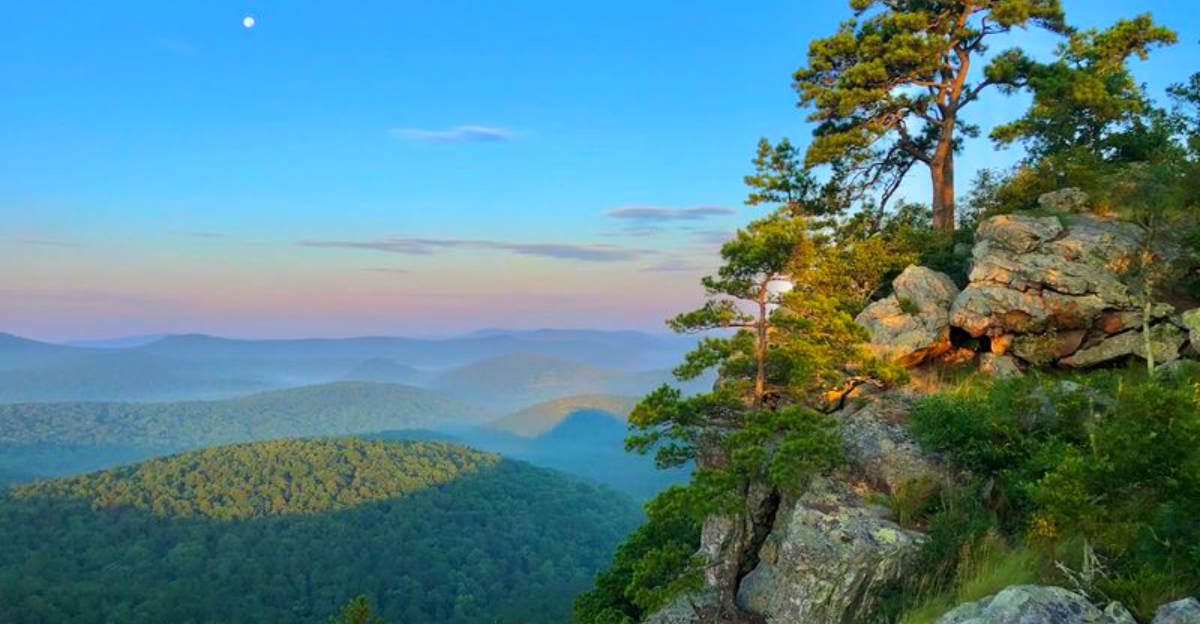
One photo of Hawksbill Crag is enough to make anyone clear their weekend schedule. This sandstone outcrop juts dramatically over a sweeping valley of Ozark hills, and it has become the most photographed natural landmark in Arkansas for very good reason.
The trail itself is about 2.9 miles round trip, starting from the Whitaker Creek Trailhead near Deer, Arkansas. Most hikers find the terrain manageable, though the uneven rocky path near the crag requires some careful footing.
The real reward waits at the end, where the land simply drops away and the view opens up in every direction. Fall is arguably the best time to visit, when the forested hills below turn into a patchwork of orange and gold.
Arrive early on weekends to beat the crowds, because this spot draws hikers from across the region who all want the same iconic photo from the tip of the crag.
2. Lost Valley Trail, Ponca, Arkansas

Not many 2.3-mile trails can pack in a creek, a canyon, a waterfall, and a cave, but Lost Valley Trail manages all four without breaking a sweat. Located in the Boxley Valley area near the Buffalo National River, this route is consistently ranked among the most beautiful short hikes in the entire state.
The trail follows Clark Creek through a narrow canyon lined with towering limestone bluffs. Most of the path is flat and easy, though the final push toward Eden Falls gets a bit steeper and rockier.
Eden Falls itself drops into a mossy grotto, and adventurous hikers can squeeze into Eden Cave just behind it for a bonus underground experience. The canyon walls rise dramatically around you, making the whole route feel much more remote than it actually is.
Families with older kids find this trail especially rewarding because each section delivers something new before the next one takes over.
3. Glory Hole Falls Trail, Ozark National Forest, Arkansas

Arkansas geology does not play by the rules, and Glory Hole Falls is the proof. Water drops through a natural hole punched directly through an overhanging sandstone ledge, creating a waterfall that looks more like a special effect than something nature built on its own.
The trail to reach it is short, roughly 2 miles round trip from the Long Pool Recreation Area, making it one of the more accessible hikes on this list. The path winds through dense forest before the terrain drops into a small hollow where the falls come into view.
Glory Hole is most impressive during spring or after significant rainfall, when water volume is highest and the falls put on their best show. During dry summer stretches, the flow can slow to a trickle.
Even so, the surrounding sandstone formations and forested hollow make the hike worth the trip regardless of season. This is the kind of trail that photographers and curious first-timers both enjoy equally.
4. Pedestal Rocks Loop Trail, Pelsor, Arkansas

Geology rarely looks this theatrical. Pedestal Rocks Loop Trail in the Ozark National Forest near Pelsor features massive sandstone columns that rise from the forest floor like natural sculptures, each one carved over millions of years into shapes that seem almost intentional.
The loop covers about 2.3 miles and is rated moderate, with some uneven terrain near the rock formations and overlooks. Multiple viewpoints along the route offer sweeping views across the rolling Ozark hills, giving hikers both geological curiosity and classic mountain scenery in a single outing.
The pedestal formations themselves are the clear stars here, and getting close to the base of these columns gives a real sense of just how tall they stand. The trail connects with the Kings Bluff Loop nearby, so ambitious hikers can combine both routes for a longer day.
Spring and fall offer the most comfortable hiking conditions, and the changing foliage in autumn frames the stone columns in a completely different way.
5. King’s Bluff Trail, St. Paul, Arkansas

King’s Bluff is the kind of trail that makes you feel like you have discovered something the rest of the world has not quite found yet. Tucked into the Ozark National Forest near St. Paul, the trail leads to a sweeping cliffside overlook with views that roll across forested ridges as far as you can see.
The route is about 2 miles round trip and is generally accessible for hikers of moderate fitness. After periods of heavy rain, a seasonal waterfall appears at the bluff edge, adding a bonus feature that makes wet-weather visits particularly rewarding.
The bluff itself sits at a satisfying height above the surrounding forest, and the open rocky ledge provides plenty of room to sit and take in the view without feeling crowded. This trail pairs well with the nearby Pedestal Rocks Loop, and many hikers tackle both in a single day.
The remote feel of King’s Bluff is one of its biggest draws, even though it is a reasonable drive from Fayetteville.
6. Eagle Rock Loop, Ouachita National Forest, Arkansas

Serious hikers talk about Eagle Rock Loop the way marathon runners talk about their first marathon, with a mix of pride, exhaustion, and an immediate desire to do it again. This 27-mile loop through the Ouachita National Forest is one of the most demanding and rewarding multi-day hikes in the South.
The route crosses the Cossatot River multiple times, climbs rocky ridgelines, and passes through stretches of wilderness that see relatively little foot traffic. Each section of the loop brings a different type of terrain, from dense pine and hardwood forest to open ridge crests with long views across the Ouachita Mountains.
Most hikers complete the loop over two to three days, camping along the route at designated sites. The river crossings can be tricky after heavy rain and require careful judgment about water levels before attempting.
Fall is the most popular season for the loop, when cooler temperatures make the long mileage much more manageable and the forest color is at its best.
7. Pinnacle Mountain West Summit Trail, Roland, Arkansas

Central Arkansas has its own mountain, and it is more impressive than most people expect from a state park sitting just west of Little Rock. Pinnacle Mountain rises sharply above the surrounding landscape, and the West Summit Trail tackles the steepest and most direct route straight to the top.
The trail is only about 1.5 miles round trip, but do not let that short distance fool you. The upper section involves scrambling over large boulders and requires using both hands in places, giving the climb a genuine adventure feel that flat trails cannot match.
At the summit, the view opens up dramatically over Lake Maumelle and the broad Arkansas River Valley, with forested hills stretching toward the horizon. On clear days, the Little Rock skyline is visible to the east.
This is one of the best bang-for-your-effort hikes in Arkansas, delivering a summit experience and panoramic views without requiring a full day on the trail.
8. Yellow Rock Trail, Devil’s Den State Park, Arkansas

Devil’s Den State Park already has plenty going for it with its crevices, caves, and CCC-built stone structures, but Yellow Rock Trail adds a summit view that earns its own separate trip. The trail covers roughly 2.7 to 3.1 miles and winds through hardwood forest before arriving at a broad sandstone overlook above Lee Creek Valley.
The overlook itself is wide and flat, giving hikers room to spread out and enjoy the view without jostling for position. The valley below stretches out in a wide arc, and the surrounding ridges frame the scene on all sides.
Autumn turns Yellow Rock into one of the most spectacular viewpoints in northwest Arkansas, when the hills fill with orange, red, and yellow foliage. The trail is rated moderate and is suitable for most hikers with reasonable fitness.
Many visitors combine Yellow Rock with other trails in the park to make a full day of exploring Devil’s Den, which rewards repeat visits in different seasons.
9. Cedar Falls Trail, Petit Jean State Park, Arkansas

Cedar Falls has been drawing visitors to Petit Jean State Park for nearly a century, and after one look at a 95-foot waterfall dropping into a rocky canyon pool, it is not hard to understand the appeal. The trail is about 2 miles round trip and descends steadily from the canyon rim to the waterfall at the bottom.
The path passes through dense forest and alongside dramatic rock formations before the canyon walls close in and the falls come into view. The last section of trail is the steepest, but the payoff at the bottom makes every step worthwhile.
Petit Jean State Park was Arkansas’s first state park, established in 1923, which means Cedar Falls has been a beloved destination for multiple generations of Arkansas families. The pool at the base of the falls allows visitors to get close and explore the surrounding rocks.
Spring delivers the most powerful flow, but the falls run year-round, making Cedar Falls a reliable destination no matter when you plan your visit.
10. Flatside Pinnacle Trail, Ouachita National Forest, Arkansas

Flatside Pinnacle delivers one of the widest and most open summit views in the Ouachita Mountains, and it does so without demanding a brutal all-day effort to get there. The trail is about 3 miles round trip from the trailhead, with a consistent climb that builds gradually before reaching the rocky summit.
At the top, the view opens in nearly every direction over rolling ridges of the Ouachita National Forest. On clear days, the panorama seems to stretch endlessly, covering ridge after ridge of forested mountain country with no visible development in sight.
Photographers particularly love Flatside Pinnacle for its unobstructed sky exposure, which makes it a strong choice for sunrise and sunset shoots. The trail is also a popular spot for watching hawk migrations in autumn, when large numbers of broad-winged hawks pass over the Ouachita ridges heading south.
The combination of accessible distance, rewarding summit, and wildlife potential makes this one of the most well-rounded day hikes in central Arkansas.
11. Ouachita National Recreation Trail, Ouachita Mountains, Arkansas

At nearly 225 miles in total length, the Ouachita National Recreation Trail is less a single hike and more an entire hiking career packed into one route. Stretching from Talimena State Park in Oklahoma to Pinnacle Mountain State Park near Little Rock, it traverses the full length of the Ouachita Mountains through some of the most scenic and remote terrain in the region.
Most hikers tackle the trail in sections rather than attempting the full thru-hike, which allows them to sample the best overlooks and ridgelines without committing to weeks in the backcountry. Ridge sections near the Ouachita Divide offer particularly impressive long-distance views across valleys and forested mountain country.
The trail passes through both Arkansas and Oklahoma, crossing streams, climbing rocky crests, and moving through forest types that shift noticeably from one section to the next. Camping along the route is available at numerous spots.
For hikers who want to experience the full wild character of the Ouachita Mountains, this trail is the most thorough way to do it.


