Los Angeles isn’t just about traffic and skyscrapers. Within an hour or two, you can escape the city buzz and find yourself winding through coastal cliffs, mountain peaks, or desert landscapes that feel worlds away. Whether you’re craving ocean breezes or pine-scented mountain air, these day-trip drives deliver scenery that’ll fill your camera roll and clear your head.
1. Palos Verdes Drive Coastal Run
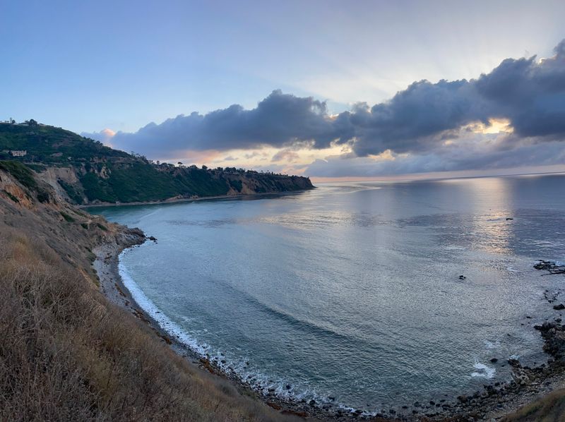
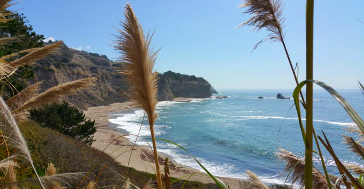
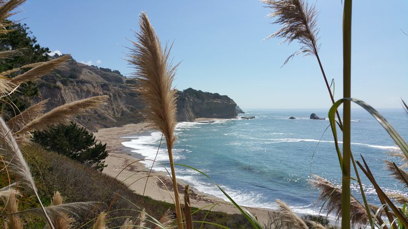
This cliff-hugging route from Palos Verdes Estates down to San Pedro is a local legend for good reason. You’ll feel like you’re driving on the edge of the world as the road snakes along dramatic bluffs with endless ocean views. On clear days, you can spot Catalina Island floating on the horizon.
The entire loop takes about an hour without stops, but you’ll definitely want to pull over at the scenic overlooks. Bring a picnic or just sit and watch the waves crash below. Early morning or late afternoon light makes the coastline glow, perfect for photography.
This drive is especially popular with cyclists and motorcyclists, so keep an eye out and share the road.
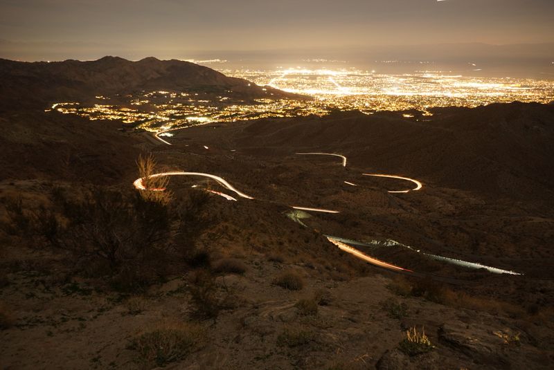
2. Mulholland Drive Overlooks in the Santa Monica Mountains
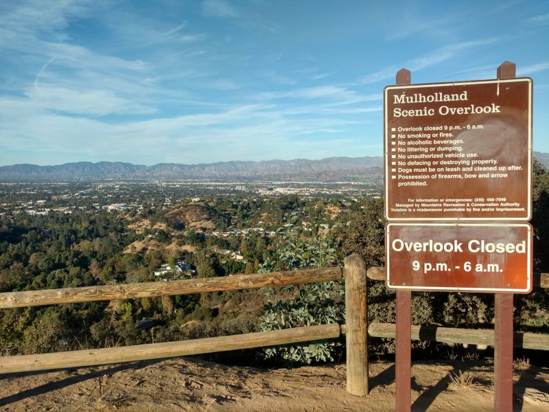
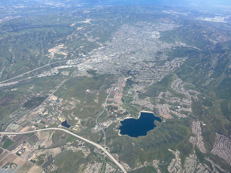
Built specifically as a scenic ridgeline road, portions of Mulholland Drive deliver some of the best city and valley panoramas you’ll find anywhere near LA. The Mulholland Scenic Parkway and Corridor stretch offers overlooks where you can see the entire basin spread out below, from downtown skyscrapers to the distant ocean.
Sunset is the prime time here. Watch the city lights start twinkling as the sky turns pink and purple. The drive itself takes about 45 minutes to an hour, depending on how many overlooks you hit.
Weekends can get crowded with tourists and photographers, so weekday afternoons offer a quieter experience. Bring water and maybe a light jacket since it can get breezy up on the ridge.
3. Topanga Canyon Boulevard: Ocean-to-Valley Canyon Crossing
Starting at PCH and climbing up through Topanga Canyon on SR-27, this drive takes you from sea level to valley floor in about 30 minutes of twisting, tree-lined road. Part of this route is officially designated a California state scenic highway, which tells you everything you need to know about the views.
The canyon itself feels like a hidden pocket of wilderness, with oak trees, sycamores, and quirky Topanga village tucked in the middle. Stop for coffee or lunch at one of the local cafes if you want to soak up the bohemian vibe. Before you go, check Caltrans for any closures related to recent fire recovery work.
This route is popular with locals commuting between the coast and valley.
4. Pacific Coast Highway to Point Mugu
Cruising northwest from Santa Monica on SR-1 through Malibu feels like the ultimate California daydream. The Pacific sparkles on one side while dramatic cliffs rise on the other, and every curve reveals another postcard-worthy view. Point Mugu State Park is where things really get special, with its mix of ocean shoreline, rocky bluffs, sand dunes, and hidden canyons.
Plan for about two to three hours of drive time, but you’ll want to budget extra for beach stops and photo ops. The park itself offers hiking trails if you’re feeling energetic. Before you head out, check Caltrans for any road work or lane closures along PCH since recovery and rehab projects pop up periodically and can slow things down unexpectedly.
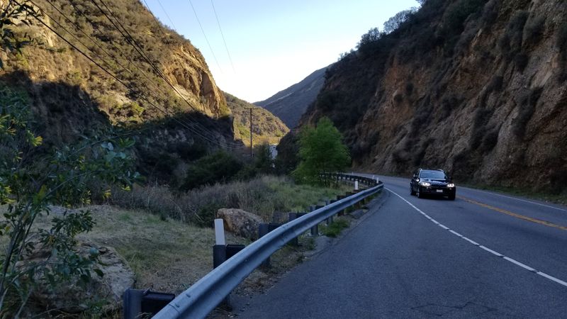
5. Mulholland Highway’s The Snake (Malibu Canyons)

Car enthusiasts and motorcycle riders dream about this stretch. Nicknamed The Snake for its tight, twisting turns, Mulholland Highway through the Santa Monica Mountains is famous for a reason. The road reopened in December 2025 after a long closure, and drivers are thrilled to have it back.
Every curve demands your full attention, but when you can safely glance away, the canyon scenery is stunning. Chaparral-covered hillsides, rock outcroppings, and glimpses of distant ridges make this feel like a real adventure. The entire section takes about 45 minutes to an hour, depending on your pace.
Important safety note: this road has a bad reputation for speeding and risky driving. Take it slow, stay in your lane, and respect other drivers.
6. Ortega Highway (SR-74): San Juan Capistrano to Lake Elsinore
Crossing the Santa Ana Mountains on SR-74, the Ortega Highway delivers tight turns, serious elevation changes, and pullout after pullout for photo stops. Starting in historic San Juan Capistrano and ending at Lake Elsinore, this route feels remote even though you’re not far from civilization.
The drive takes about an hour straight through, but plan for longer if you want to explore the lookout points. Spring wildflowers can be spectacular after a wet winter. Summer heat can be intense, so bring water and sunscreen if you plan to stop and hike.
Before you leave, check Caltrans for any active restrictions or road work. Weather and rockslides occasionally close sections temporarily, and you don’t want surprises mid-drive.
7. Rim of the World Scenic Byway (San Bernardino Mountains)

If you want a full mountain day trip, this is it. The Rim of the World Scenic Byway traverses the ridgeline of the San Bernardino Mountains across roughly 110 miles, incorporating portions of CA-138, CA-18, and CA-38. You’ll pass through pine forests, mountain communities, and scenic overlooks with views stretching for miles.
Budget a full day for this one since there’s so much to see. Stop in Big Bear Lake or Lake Arrowhead for lunch or a quick hike. Winter brings snow, which adds beauty but also driving challenges, so check road conditions carefully.
Late December 2025 saw flooding closures on parts of SR-18, so verify your specific route segment before committing. Caltrans updates are your friend here.
8. Palms to Pines Scenic Byway (Desert-to-Mountain Contrast)
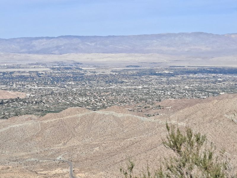
Few drives pack as much ecosystem variety into one trip as the Palms to Pines Scenic Byway. Starting in the low desert near Palm Springs and climbing into the San Jacinto and Santa Rosa mountain ranges, you’ll experience dramatic temperature drops and landscape shifts within an hour.
At the bottom, you’re surrounded by palm oases and desert heat. As you climb, cacti give way to chaparral, then oak woodlands, and finally pine forests. The contrast is stunning and makes for incredible photos.
Plan about two to three hours for the drive, plus time to explore Idyllwild or other mountain towns along the route. Bring layers since it can be 30 degrees cooler at the top than at the trailhead.
9. Joshua Tree National Park: Park Boulevard Drive
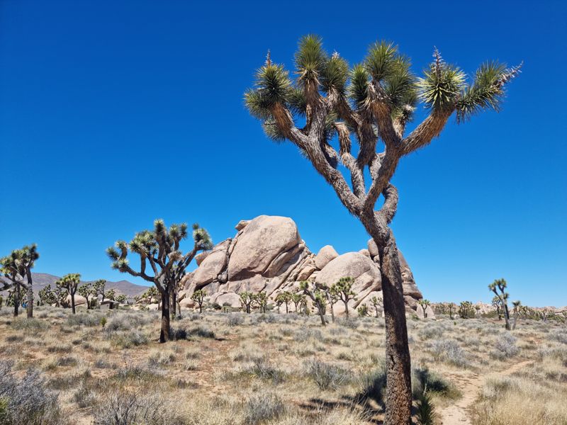
Inside Joshua Tree National Park, Park Boulevard is your ticket to seeing the park’s greatest hits without committing to a multi-day camping trip. This paved route winds through groves of iconic Joshua trees and past massive rock formations that look like they belong on another planet.
You can easily drive the main section in a couple of hours, but add time for short walks and photo stops at places like Skull Rock or Hidden Valley. Early morning and late afternoon light make the desert landscape glow. Bring plenty of water, sunscreen, and snacks since services inside the park are limited.
Entrance fees apply, so have your National Parks Pass ready or pay at the gate. Weekends and holidays get crowded, so weekday visits offer a more peaceful experience.
10. Highway 33 Toward Ojai (Ventura County)
Heading toward Ventura County and taking SR-33 in the Ojai direction gives you a relaxed, landscape-heavy day drive without the intensity of mountain switchbacks or coastal crowds. Rolling hills, oak-studded valleys, and distant mountain ridges create a peaceful, almost pastoral vibe.
Ojai itself is worth the trip, with art galleries, farm-to-table restaurants, and a reputation for wellness and relaxation. The drive from LA takes about 90 minutes, making it perfect for a leisurely day out. Spring brings green hillsides and wildflowers, while fall offers golden grasslands and crisp air.
Before you go, check Caltrans for any road work or closures on SR-33. The route is generally well-maintained, but it’s always smart to confirm current conditions and avoid surprises.
11. Angeles Crest Highway (SR-2): Mountain Views Close to the City
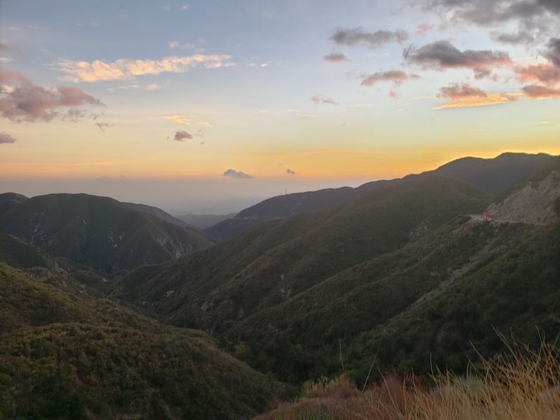
Angeles Crest Highway on SR-2 gives you that big mountain feeling without driving hours from LA. Part of SR-2 is designated a California scenic highway, and once you start climbing out of the foothills, you’ll understand why. Pine forests, rocky peaks, and sweeping vistas make this feel like a true mountain escape.
The drive to the higher elevations takes about an hour from the city, and you can extend it with stops at picnic areas or trailheads. Winter snow closes the upper sections, so this is best from late spring through fall.
Critical right now: Caltrans reported multiple SR-2 closures in late December 2025 due to weather, slides, and flooding. Treat this as a check-first-then-go route and verify current conditions before leaving home.
12. Mount Wilson Observatory Drive (via Angeles Crest Hwy)
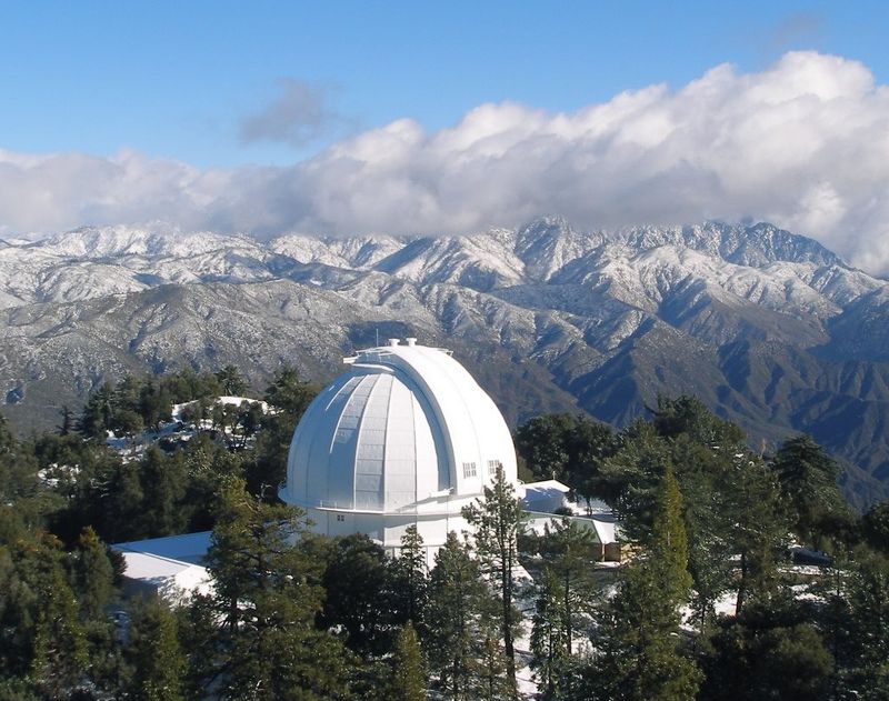
Reaching Mount Wilson Observatory is an adventure in itself. You’ll take Angeles Crest Highway (CA-2) and then turn onto Mount Wilson Road, also known as Red Box Road, for the final climb. The observatory sits at over 5,700 feet, offering stunning views of the LA basin below and the surrounding peaks.
The observatory has been a center for astronomical research for over a century, and tours are available if you time your visit right. The drive up takes about 90 minutes from LA, and the winding mountain roads require careful attention. Pack layers since temperatures drop significantly at elevation.
Because this route depends on SR-2, you must confirm current road conditions before you leave. Recent weather events have caused closures, so check Caltrans updates to avoid a wasted trip.


