Most of us think of sea level as the starting point for measuring height, but some incredible places on Earth actually sit below it. From shimmering salt lakes to bustling airports, these locations exist in a world that defies what many people expect.
Some formed naturally over millions of years, while others were carefully engineered by humans. Get ready to explore 14 remarkable places that prove Earth is full of surprises.
1. Dead Sea, Israel, West Bank and Jordan (-430 m / -1,411 ft)
")
Floating in the Dead Sea is one of those experiences people never forget. Sitting at 430 meters below sea level, it holds the title of the lowest exposed land on Earth.
The water is so dense with salt that swimmers naturally bob to the surface without even trying.
The salt concentration is nearly ten times saltier than ocean water, making it almost impossible for fish or plants to survive. That extreme salinity is actually what drew ancient civilizations to harvest its minerals for thousands of years.
Today, tourists come from around the world to float effortlessly and coat themselves in its famous black mineral mud.
The Dead Sea is shrinking at an alarming rate due to water diversion from the Jordan River. Scientists and governments are actively working on plans to save it.
Visiting soon might be the wisest choice for anyone with this destination on their bucket list.
2. Lake Assal, Djibouti (-155 m / -509 ft)
")
Lake Assal sits at the crossroads of three tectonic plates, making it one of the most geologically active spots on the planet. At 155 meters below sea level, it is Africa’s lowest point and one of the saltiest bodies of water anywhere on Earth.
The landscape surrounding it looks almost alien, with jagged black lava fields meeting blindingly white salt flats.
The lake’s salt crust is so thick in places that people can walk across it. Local Afar communities have harvested salt from its shores for generations, loading camels with blocks of it to trade across the region.
It is a tradition that has continued largely unchanged for centuries.
Temperatures around Lake Assal regularly exceed 50 degrees Celsius, making it one of the hottest places in Africa as well. Visiting requires serious preparation, but the surreal scenery rewards every traveler who makes the effort to reach it.
3. Turpan Depression, Xinjiang, China (-154 m / -505 ft)
")
Buried deep in the heart of Central Asia, the Turpan Depression is one of the most extreme environments China has to offer. At 154 meters below sea level, it cradles Ayding Lake, a shallow, highly saline lake that sits even lower than the surrounding basin floor.
Summer temperatures here regularly top 47 degrees Celsius, earning Turpan the nickname “China’s Oven.”
Despite the punishing heat, humans have lived here for over two thousand years. Ancient underground irrigation tunnels called karez channels carry snowmelt from distant mountains, allowing vineyards and farms to thrive in an otherwise scorching desert.
The grapes grown here produce some of China’s most famous raisins.
The Flaming Mountains, a range of striking red sandstone ridges, frame the depression dramatically. Their vivid color deepens at sunset, creating a scene that feels more like a painting than a real place.
Turpan is a destination that continually surprises visitors expecting nothing but sand.
4. Qattara Depression, Egypt (-133 m / -436 ft)
")
Few places on Earth feel as remote and untouched as Egypt’s Qattara Depression. Stretching roughly 300 kilometers in length and dropping to 133 meters below sea level, it ranks among the largest natural depressions in the world.
Yet almost no one lives there, and very few roads cross it.
The terrain is a challenging mix of quicksand, salt marshes, and crumbling cliffs that made it nearly impassable for military vehicles during World War II. This natural barrier actually played a strategic role in the North Africa campaign, limiting where armies could maneuver.
Military historians still study the depression’s geography when analyzing battles from that era.
Engineers have long proposed flooding the depression with Mediterranean seawater to generate hydroelectric power. The idea has never moved forward due to cost and environmental concerns, but it remains one of the most ambitious engineering proposals ever seriously considered in Africa.
The Qattara stays wild, silent, and largely unexplored.
5. Danakil Depression, Ethiopia (-125 m / -410 ft)
")
Calling the Danakil Depression colorful would be an understatement. This geothermal wonderland in northeastern Ethiopia sits 125 meters below sea level and looks like something from another planet entirely.
Brilliant yellow sulfur vents, neon-green acid pools, and glowing lava lakes create a visual spectacle unlike anywhere else on Earth.
It is also one of the hottest and most volcanically active places humans have ever explored. Active volcanoes like Erta Ale have been continuously erupting for over a century, their lava lakes bubbling day and night.
Local Afar people have lived near this extreme environment for generations, harvesting salt from the flats in one of the world’s most physically demanding jobs.
Scientists are deeply interested in the Danakil because its extreme conditions may mimic early Earth or even environments on other planets. Microbial life found thriving in its acid pools offers clues about where life might exist beyond our world.
Adventure travelers with a high tolerance for heat consider it a once-in-a-lifetime destination.
6. Badwater Basin, Death Valley National Park, California, USA (-86 m / -282 ft)
")
Standing at Badwater Basin feels like standing at the bottom of a bowl the size of a continent. At 86 meters below sea level, it is the lowest point in all of North America.
A small sign on the cliff face across the road marks the height of sea level far above your head, which makes for a genuinely mind-bending photo opportunity.
The basin floor is covered in a thick crust of salt that forms intricate hexagonal patterns, created by the repeated cycle of flooding and evaporation over thousands of years. During rare winter rains, a shallow lake briefly forms, reflecting the mountains and sky in an almost mirror-like surface.
It disappears within days as the desert heat returns.
Death Valley as a whole holds the record for the highest reliably recorded air temperature on Earth at 56.7 degrees Celsius. Visiting Badwater Basin in summer requires serious caution, plenty of water, and an early morning start to avoid the worst of the heat.
7. Salton Sea, California, USA (-71 m / -236 ft)
")
The Salton Sea has a story that reads like a cautionary tale about unintended consequences. It was accidentally created in 1905 when an irrigation canal breach caused the Colorado River to flow into the Salton Sink for nearly two years.
The resulting lake now sits 71 meters below sea level and covers about 970 square kilometers, making it California’s largest lake by surface area.
For a few decades in the mid-20th century, the Salton Sea was a glamorous resort destination with yacht clubs, hotels, and celebrity visitors. Then the water grew too salty and too polluted, fish populations collapsed, and the resorts were abandoned.
Today, those crumbling structures have become a hauntingly beautiful subject for photographers and urban explorers.
Environmental efforts are underway to restore parts of the ecosystem, particularly for migratory birds that still rely on it heavily. The Salton Sea remains a strange and compelling place, equal parts ecological tragedy and unexpected wildlife refuge.
Its future is still very much unwritten.
8. Sea of Galilee, Israel (-209 m / -686 ft)
")
The Sea of Galilee carries centuries of history in its waters. At 209 meters below sea level, it holds the distinction of being the world’s lowest freshwater lake.
Despite its name, it is actually a lake, fed primarily by the Jordan River and underground springs that pour in from the surrounding hills.
For Christians, this body of water is among the most sacred places on Earth. According to the New Testament, Jesus walked on its surface and calmed a storm here.
Pilgrims from around the world come to its shores every year, many choosing to be baptized in its waters as a deeply personal act of faith.
Beyond its spiritual significance, the Sea of Galilee supplies a significant portion of Israel’s freshwater needs. Drought and population growth have put serious pressure on its water levels in recent decades.
Conservation programs have helped stabilize it somewhat, but water management remains a critical ongoing challenge for the entire region.
9. Jordan Rift Valley, Jordan and Israel (largely below sea level)
")
Stretching from Lebanon in the north all the way to the Red Sea, the Jordan Rift Valley is one of the most dramatic geological features on the planet. Much of the valley floor sits well below sea level, carved out over millions of years as tectonic plates slowly pulled apart.
The result is a long, deep trench that continues to widen by a few millimeters every year.
The Jordan River runs through the valley’s heart, historically one of the most significant rivers in the world for both agriculture and religion. Today, only a fraction of its original flow remains after decades of water diversion for irrigation and drinking water.
Sections that once ran broad and clear now trickle through muddy, narrow channels.
The valley is also a critical migration corridor for hundreds of bird species traveling between Europe, Asia, and Africa each year. Birdwatchers consider it one of the best spots in the Middle East for spotting rare species.
The rift’s biodiversity is as impressive as its geological drama.
10. Flevoland, Netherlands (up to -5.5 m / -18 ft)
")
Flevoland is proof that human ambition can literally reshape the map. Completed in stages between 1957 and 1968, it is the largest artificial island ever created, reclaimed entirely from the former Zuiderzee, an inland sea that once dominated the center of the Netherlands.
At up to 5.5 meters below sea level, it exists only because of an extraordinary network of dikes, pumping stations, and drainage canals.
Today, more than 400,000 people call Flevoland home, living in modern cities like Lelystad and Almere that were built from scratch on land that was underwater just decades ago. The province is one of the Netherlands’ youngest, and it has a planned, orderly feel that reflects its engineered origins.
Farmers on Flevoland benefit from exceptionally fertile soil, since the reclaimed lakebed is rich in nutrients. The province produces a significant share of the Netherlands’ vegetables and tulips.
Walking through its perfectly flat fields, it is hard to believe you are standing on what was once open water.
11. Amsterdam Airport Schiphol, Netherlands (-3 m / -11 ft)
")
Amsterdam Airport Schiphol is not just one of Europe’s busiest airports, it is also one of the very few international airports in the world that sits below sea level. At 3 meters below the ocean’s surface, the runways and terminals occupy land that was once the bed of the Haarlemmermeer lake, drained by Dutch engineers in the 1850s.
The name Schiphol itself likely comes from an old Dutch phrase meaning “ship hole,” referencing the treacherous waters that once existed here.
More than 71 million passengers passed through Schiphol in the years before the pandemic disrupted global travel. It consistently ranks among the world’s top airports for passenger experience, with excellent shopping, dining, and transit connections.
Travelers often choose Amsterdam as a hub specifically because of Schiphol’s smooth and efficient layout.
The airport also has its own Rijksmuseum branch inside the terminal, where travelers can view original Dutch masterpieces between flights. It is possibly the only place in the world where you can catch a Rembrandt before boarding a plane.
That detail alone says a lot about the Dutch approach to culture.
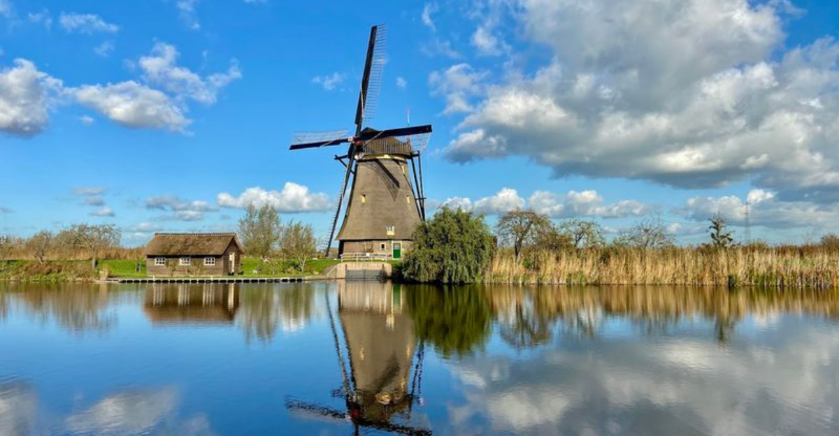
12. Kinderdijk, Netherlands (below sea level)
")
Few images say “Netherlands” more powerfully than the windmills of Kinderdijk. Nineteen beautifully preserved windmills line the canals of this UNESCO World Heritage Site, standing as living monuments to centuries of Dutch ingenuity in managing water.
The land they protect has sat below sea level for hundreds of years, and without these mills and the pumping systems that followed them, it would simply flood.
The windmills were built in the 1740s to drain excess water from the polders into higher canals, from where it could flow out to sea. They worked in coordinated shifts depending on wind direction and water levels, a system that required constant human attention and skill.
Several of the mills are still inhabited by families today, maintaining a tradition that stretches back generations.
Kinderdijk draws around one million visitors every year, and it is easy to see why. The combination of history, engineering, and scenery is genuinely hard to match anywhere in the world.
Cycling along the canal paths at sunset here is an experience that stays with you long after you leave.
13. Holme Fen, Cambridgeshire, England (-2.75 m / -9 ft)
")
Holme Fen holds the modest but genuine distinction of being the lowest land point in the United Kingdom. Sitting 2.75 meters below sea level in the flat Cambridgeshire fens, it was once part of a vast peat bog that covered much of eastern England.
When the surrounding fenland was drained for agriculture in the 19th century, the peat began to dry out and shrink, causing the land to sink gradually over the following decades.
A famous iron post was driven into the peat at Holme Fen in 1851 to measure exactly how much the land was sinking over time. Back then, the top of the post sat level with the ground.
Today, it protrudes about four meters above the surface, a striking visual record of how dramatically the land has dropped. It is one of the most compelling examples of human-caused land subsidence anywhere in Europe.
The area is now a peaceful nature reserve managed by Natural England, home to silver birch woodland, rare insects, and quiet walking trails. Most visitors come specifically to see the famous post and reflect on what it represents about land use and change.
14. Hachirogata Reclaimed Land, Akita Prefecture, Japan (below sea level)
")
In the 1950s and 1960s, Japan undertook one of its most ambitious postwar agricultural projects by draining much of Lake Hachirogata, the country’s second-largest lake at the time. The result was a large expanse of reclaimed land in Akita Prefecture that now sits below sea level, dedicated almost entirely to rice farming.
The project was designed to help feed a rapidly growing population in the years following World War II.
Drainage pumps run continuously to keep the reclaimed fields dry, since the surrounding lake still exists partially around the edges of the reclaimed zone. The flat, geometric layout of the fields from the air is strikingly orderly, a visual reflection of the careful planning that went into the project.
Rice grown here is considered some of the finest in Japan, benefiting from the region’s fertile soil and clean mountain water.
The project is now studied by engineers and urban planners worldwide as a reference point for large-scale land reclamation. It raises thoughtful questions about balancing agricultural needs with natural ecosystem preservation, questions that remain highly relevant today.


