
Our planet is full of breathtaking landscapes, but some of those places are so extreme that even the toughest adventurers would struggle to last a day. From scorching deserts to frozen wastelands, Earth hides corners where nature shows no mercy.
These places test the limits of human endurance in ways most of us can barely imagine. Buckle up, because this tour of Earth’s most hostile environments is anything but ordinary.
Antarctica
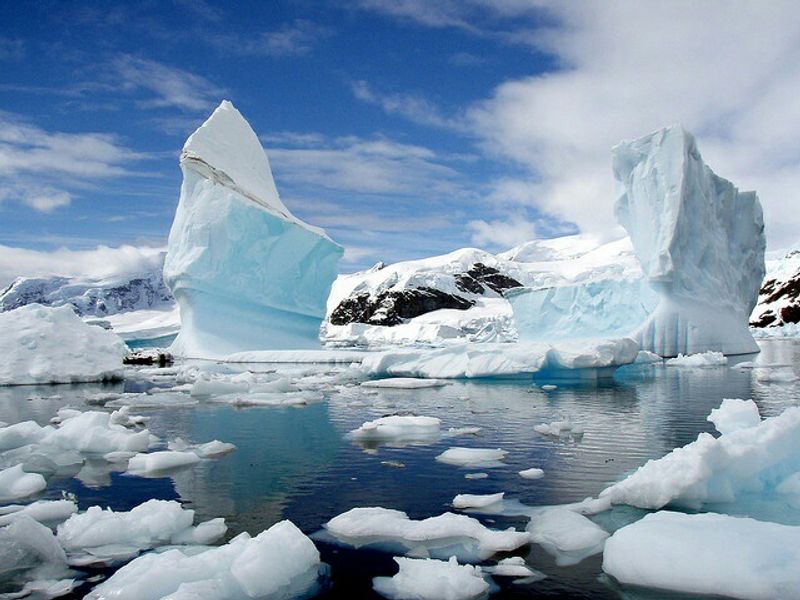
Step outside in Antarctica without the right gear, and you could freeze solid faster than you can say “bad idea.” This frozen continent sits at the bottom of the world and holds the record for the coldest temperature ever measured on Earth — a bone-chilling minus 89.2 degrees Celsius at the Soviet Vostok Station in 1983.
Antarctica is bigger than Europe and almost entirely buried under ice. The continent gets so little precipitation that it technically qualifies as a desert.
Winds can howl at over 300 kilometers per hour, blasting ice crystals with enough force to strip exposed skin raw.
During winter, the sun disappears for months, leaving scientists at research stations in complete darkness. Only a few thousand researchers live there at any given time, and they rely entirely on supplies flown in from the outside world.
Fresh food is a luxury. Every single resource must be carefully managed.
Frostbite can set in within minutes of unprotected exposure, and even experienced polar explorers treat this continent with enormous respect.
Death Valley — United States
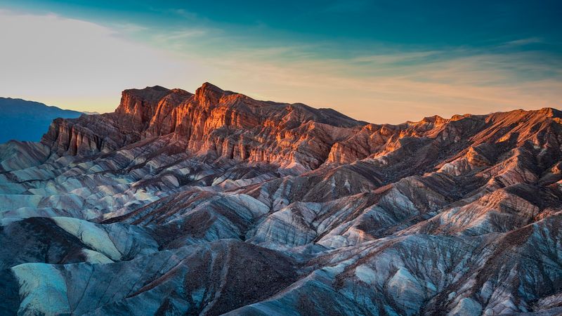
On July 10, 1913, a thermometer in Death Valley hit 56.7 degrees Celsius — the highest air temperature ever officially recorded anywhere on Earth. That reading was not a fluke.
This California desert sits well below sea level in a basin where hot air gets trapped and baked by relentless sunshine.
The valley floor reflects heat back upward, creating a double-whammy of scorching temperatures from above and below. Water evaporates so quickly here that sweat dries before you even notice it, which tricks people into thinking they are not dehydrating.
That is a dangerous illusion. Hikers have died here even with water in their backpacks, simply because they did not drink enough fast enough.
The landscape looks almost alien — cracked salt flats, towering sand dunes, and jagged rock formations stretch in every direction. Park rangers strongly advise against hiking during summer months, especially in the middle of the day.
If your car breaks down on a remote road out here, staying with the vehicle is your best chance of survival. Death Valley earns its grim name every single summer.
Atacama Desert — Chile
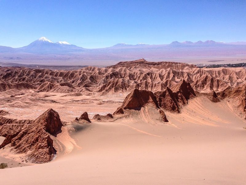
Some parts of the Atacama Desert have not seen a single drop of rain in over 400 years. Let that sink in for a moment.
Located along the Pacific coast of South America, this desert is squeezed between two mountain ranges that block moisture from both sides, creating a rain shadow so extreme it borders on surreal.
The landscape looks more like the surface of Mars than anything you would expect on Earth. NASA actually uses the Atacama to test Mars rovers because the conditions are so similar.
Temperatures swing wildly between day and night, sometimes dropping below freezing after a sweltering afternoon. That kind of thermal shock makes it brutally hard on both equipment and the human body.
Very few animals and plants manage to survive here. Those that do have evolved remarkable tricks — some beetles collect moisture from coastal fog, and certain cacti grow extraordinarily deep root systems.
For unprepared humans, the combination of intense UV radiation, altitude sickness, and extreme dryness is a triple threat. Even experienced desert travelers carry emergency supplies and GPS devices when venturing into the Atacama’s most remote stretches.
Danakil Depression — Ethiopia
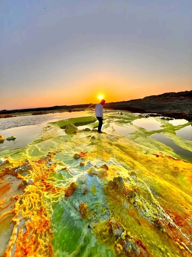
Imagine a place where the ground bubbles, the air smells like rotten eggs, and the temperature rarely dips below 34 degrees Celsius — even at night. Welcome to the Danakil Depression, one of the most geologically active and brutally hot places on the entire planet.
Sitting about 100 meters below sea level in northeastern Ethiopia, this region is essentially a giant natural laboratory of extreme geology. Lava lakes, acidic hot springs, and salt flats stretch across a landscape painted in vivid yellows, greens, and oranges from mineral deposits.
It is visually spectacular and physically punishing at the same time.
Toxic gases, including sulfur dioxide and hydrogen sulfide, drift through the air and can cause serious respiratory problems without proper protection. Local Afar communities have lived near this region for centuries, mining salt from the flats — one of the toughest and most dangerous jobs imaginable.
Scientists who visit to study the area wear gas masks and carry emergency oxygen. The average annual temperature here is around 34 degrees Celsius, making it the hottest inhabited region on Earth by yearly average.
Most people visit only with armed guides and specialized equipment.
Mount Everest — Nepal/Tibet
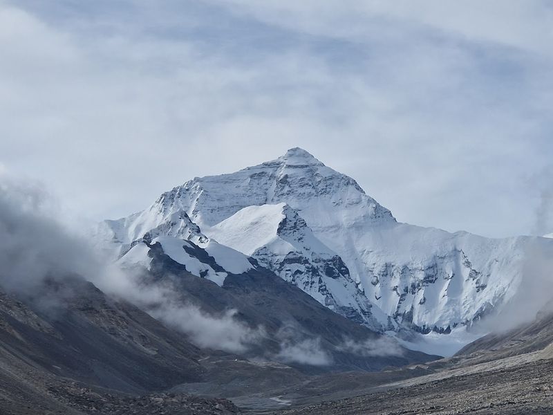
Above 8,000 meters, the air is so thin that the human body literally begins shutting down — no matter how fit you are. Climbers call this altitude range the “Death Zone,” and the name is not an exaggeration.
Mount Everest’s summit sits at 8,849 meters above sea level, placing it firmly inside that deadly threshold.
Oxygen levels at the top are roughly one-third of what they are at sea level. Most climbers use supplemental oxygen tanks, but even with help, the brain and muscles deteriorate rapidly.
Frostbite can claim fingers and toes in minutes. Winds regularly exceed 200 kilometers per hour, and temperatures can plunge to minus 60 degrees Celsius.
Avalanches can strike without warning.
Over 300 people have died on Everest, and many of their bodies remain on the mountain because recovery is nearly impossible at that altitude. The climb typically takes two months including acclimatization, costs tens of thousands of dollars, and requires months of intense physical preparation.
Even experienced mountaineers have turned back just meters from the summit because the risk became too great. Everest does not care about your fitness level, your experience, or your determination.
It plays by its own brutal rules.
Sahara Desert — North Africa
Covering roughly 9.2 million square kilometers, the Sahara is larger than the continental United States. Yet despite its enormous size, only a handful of scattered oases and isolated settlements dot this ocean of sand and rock.
Getting lost here is not just inconvenient — it is a death sentence without rescue.
Daytime temperatures routinely top 50 degrees Celsius, while nights can drop near freezing. That 40-degree daily swing is physically exhausting for the human body to manage.
The desert also generates massive sandstorms called haboobs, walls of sand that can rise kilometers high and reduce visibility to absolute zero within seconds. Getting caught in one without shelter is terrifying.
Water is the single most critical resource here. A person can die of dehydration in as little as two days in Sahara-level heat.
Traditional Tuareg and Bedouin peoples have navigated this desert for thousands of years using deep knowledge of star patterns, wind directions, and hidden water sources passed down through generations. Modern explorers rely on GPS, satellite phones, and pre-cached water supplies.
Even with all that technology, Sahara crossings still go wrong. Respect for this desert is not optional — it is the price of survival.
Oymyakon — Russia
In Oymyakon, Russia, eyelashes freeze, car engines must run all night or they will not start again, and outdoor thermometers have been known to shatter because they were not built for temperatures this extreme. This tiny Siberian village holds the record for the lowest temperature ever recorded in a permanently inhabited settlement: minus 67.7 degrees Celsius in 1933.
About 500 people call Oymyakon home year-round, which makes it simultaneously one of the most impressive and puzzling facts about human stubbornness. The ground is permanently frozen, so growing crops is essentially impossible.
Residents rely heavily on meat and fish for nutrition, as fresh vegetables are a rare luxury.
Even getting to the nearest city requires an 800-kilometer drive on a road nicknamed the “Road of Bones.”
Visiting in winter means bundling in multiple layers of fur and wool just to step outside for a few minutes. Mobile phones die instantly in the cold.
Glasses freeze to your face. Locals joke that even the cold is cold here.
Despite all of this, Oymyakon has become a bizarre tourist attraction for extreme travelers seeking bragging rights. Just pack very, very warm clothes — and maybe a backup thermometer.
Karakum Desert — Turkmenistan

Right in the middle of the Karakum Desert in Turkmenistan, there is a hole in the ground that has been on fire since the early 1970s. Known as the Darvaza Gas Crater or the “Door to Hell,” this 70-meter-wide pit was created when Soviet engineers accidentally collapsed a natural gas cavern during drilling.
They set it on fire to burn off the gas, expecting it to go out in a few days. It is still burning today.
The surrounding desert is no gentler. Summer temperatures in the Karakum regularly exceed 50 degrees Celsius.
Violent sandstorms sweep across the flat terrain with little warning, and fresh water sources are scarce across most of the desert’s 350,000 square kilometers. The landscape is overwhelmingly beige and brutally exposed to the sun.
Most of Turkmenistan’s population clusters near rivers and oases, staying well away from the harshest interior regions. Camels remain one of the most practical forms of transport in remote areas because they handle the heat and water scarcity far better than any vehicle.
The Door to Hell draws curious tourists each year, but lingering near its toxic fumes for too long is genuinely dangerous. Some adventures are better enjoyed briefly.
Amazon Rainforest — South America
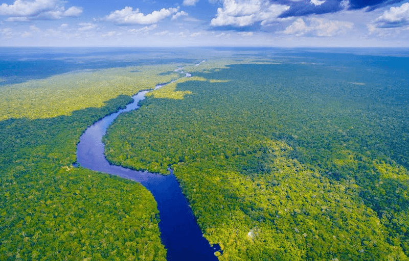
More species of plants, insects, and animals live in the Amazon than almost anywhere else on Earth — and a disturbing number of them can kill you. The Amazon Rainforest covers over 5.5 million square kilometers across nine countries, making it the largest tropical rainforest on the planet.
It is also one of the most disorienting and dangerous places a human can get lost.
The canopy overhead blocks sunlight so effectively that navigating on foot without a compass or GPS is nearly hopeless. Every direction looks identical.
The forest floor is damp, shadowy, and teeming with hazards — venomous snakes, bullet ants, electric eels, jaguars, and parasites that would make your skin crawl. Literally.
Certain parasitic organisms can burrow under skin or enter through water.
Tropical diseases like malaria, dengue fever, and leishmaniasis are genuine threats that kill thousands of people in the region every year. Humidity stays above 80 percent almost constantly, making physical exertion exhausting and accelerating dehydration faster than most people expect.
Indigenous communities who have lived in the Amazon for thousands of years possess extraordinary knowledge about safe food, water, and navigation. Without that knowledge, surviving more than a few days in deep jungle is extraordinarily difficult for outsiders.
Snake Island (Ilha da Queimada Grande) — Brazil
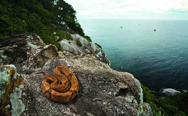
There is an island off the coast of Brazil where you cannot take a single step without risking a potentially fatal snakebite. That is not a metaphor.
Snake Island, known locally as Ilha da Queimada Grande, is home to an estimated 2,000 to 4,000 golden lancehead pit vipers — one of the most venomous snakes in the entire world.
The golden lancehead’s venom is so potent it can melt human flesh around the bite wound. Researchers estimate that snakes outnumber usable ground by roughly one snake per square meter in the densest areas.
The Brazilian Navy strictly prohibits civilians from visiting the island, and even scientists who receive special permission must be accompanied by a doctor.
How did so many deadly snakes end up on one island? When sea levels rose thousands of years ago, the snakes became isolated from the mainland.
With no ground predators to worry about, their population exploded. The snakes evolved especially fast-acting venom to catch migratory birds — their primary food source — before the birds could fly away after being struck.
It is a perfect example of evolution producing something spectacularly dangerous. The Brazilian government keeps this island off-limits for very good reason, and frankly, that seems like a completely reasonable policy.
Lake Natron — Tanzania
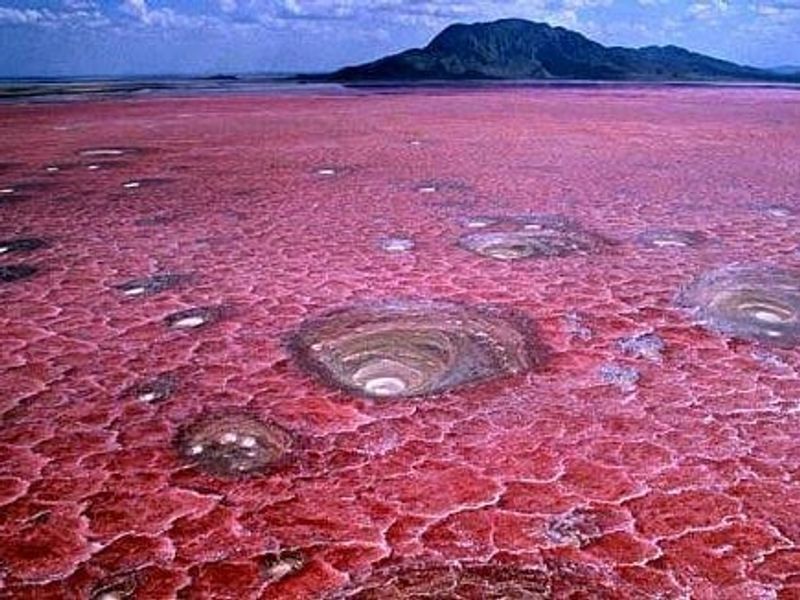
Lake Natron in Tanzania looks like something from a nightmare — or a surrealist painting. The water is a deep red and pink, the surface is crusted with salt, and the temperature can reach 60 degrees Celsius in some areas.
This is one of the most caustic bodies of water on Earth, with a pH level as high as 10.5 — nearly as alkaline as ammonia.
The lake gets its vivid color from salt-loving microorganisms called haloarchaea, which produce reddish pigments. For most animals, contact with the water is deadly.
The alkalinity can calcify the skin and eyes of animals that fall in, effectively turning them to stone. Photographer Nick Brandt famously documented calcified animal carcasses along the shoreline, creating haunting and unforgettable images.
Strangely, the lake is not entirely lifeless. Lesser flamingos breed here by the millions, nesting on salt islands that predators cannot safely cross.
Tilapia fish have also adapted to survive in the warmer, slightly less caustic inlet streams. For humans, however, Lake Natron is firmly in the “look but do not touch” category.
The surrounding terrain is equally challenging — remote, volcanic, and scorching hot. It is beautiful in a completely terrifying way.
McMurdo Dry Valleys — Antarctica
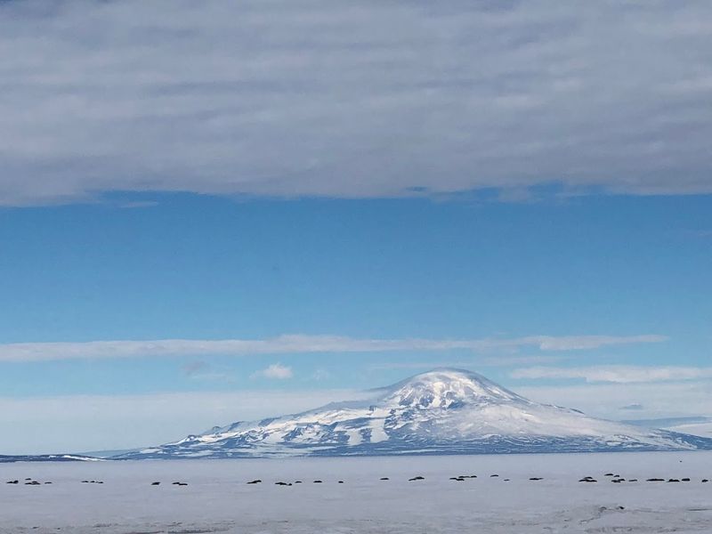
Surrounded by one of the iciest continents on Earth, the McMurdo Dry Valleys somehow manage to be almost completely free of snow and ice. These valleys in Antarctica are among the driest deserts on the planet, receiving less than 100 millimeters of precipitation per year.
Strong, warm katabatic winds blow down from the mountains and evaporate any moisture before it can accumulate.
The result is a haunting, barren landscape of exposed brown and red rock that looks more like a Mars simulation than anything on Earth. NASA has used these valleys to test instruments intended for Mars missions, and the comparison is remarkably accurate.
Temperatures still drop well below minus 30 degrees Celsius in winter, so despite the lack of snow, it is still brutally cold.
Almost nothing lives here. A few species of bacteria, algae, and microscopic nematode worms manage to survive in the soil and rocks, but visible animal life is essentially absent.
Scientists have discovered liquid water lakes hidden beneath the ice in some areas, which raises fascinating questions about life on other planets. For human survival without equipment, the McMurdo Dry Valleys offer the worst of two worlds — the cold of Antarctica and the dryness of a desert, simultaneously.
Not exactly a vacation destination.
The Darien Gap — Panama/Colombia
The Pan-American Highway stretches from Alaska all the way to the southern tip of Argentina — except for one notorious break. A roughly 100-kilometer stretch of jungle between Panama and Colombia called the Darien Gap has defeated every attempt to build a road through it.
The terrain is simply too brutal, too wet, and too dangerous.
Swamps, rivers, mountain ridges, and impenetrable jungle combine to make this one of the most physically punishing environments on the planet. Rainfall can exceed 3,000 millimeters per year, turning the ground into a perpetual muddy obstacle course.
Venomous snakes, disease-carrying insects, and jaguars are constant concerns. There are no rescue services, no phone signal, and almost no infrastructure of any kind.
Despite all of this, tens of thousands of migrants attempt to cross the Darien Gap each year in hopes of reaching North America. The journey typically takes five to ten days on foot, and many do not make it.
Exhaustion, disease, drowning, and violence have all claimed lives along this route. Humanitarian organizations describe the crossing as one of the most dangerous journeys a person can attempt anywhere in the world.
The Darien Gap does not discriminate — it is equally brutal to everyone who tries to cross it.
Surtsey Island — Iceland
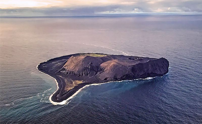
Surtsey did not exist before November 14, 1963. On that date, a volcanic eruption began beneath the North Atlantic Ocean off the southern coast of Iceland, and within weeks a brand-new island had pushed itself above the surface of the sea.
It is one of the youngest pieces of land on Earth, and watching it form must have been one of the most astonishing things any sailor has ever witnessed.
The island is entirely off-limits to the public. Scientists convinced Icelandic authorities to restrict access almost immediately, recognizing that Surtsey offered a once-in-a-millennium opportunity to observe how a completely sterile landscape gets colonized by life from scratch.
Even the scientists who visit follow strict protocols to avoid accidentally introducing outside organisms. Every boot, every piece of equipment, every item of clothing must be sterilized before landing.
The volcanic terrain itself is harsh and unstable — black lava fields, sharp rock formations, and coastal erosion constantly reshape the island. Waves have already eaten away a significant portion of Surtsey since its formation.
Wind and sea spray make the environment cold, wet, and unforgiving year-round. For the handful of researchers lucky enough to visit, it is a privilege wrapped in discomfort.
For everyone else, Surtsey remains one of Earth’s most exclusive and extraordinary no-go zones.


