Some places on Earth look so beautiful they almost seem unreal. Coastlines are among the most stunning of these places, where land meets ocean in ways that can stop you in your tracks.
From towering sea cliffs to crystal-clear bays framed by colorful villages, the world’s most dramatic shores offer scenery that no painting could fully capture. Whether you love road trips along rugged cliffs, boat rides through ancient fjords, or simply standing at the edge of the sea with the wind in your face, this list has something that will make you want to pack a bag.
These 15 coastlines span six continents and range from well-known classics to routes that many travelers still overlook. Each one has earned its place on this list for a specific reason, and by the time you reach the end, you may already be searching for flights.
Nā Pali Coast, Kauai, Hawaii, USA

Rising more than 4,000 feet straight out of the Pacific Ocean, the Nā Pali Coast on Kauai’s northwest shore is one of the most visually striking stretches of land in the United States. The name means “the cliffs” in Hawaiian, and that is exactly what you get: a series of razor-sharp ridges, deep valleys, and sea caves carved over millions of years.
Access is part of what makes this coastline so special. There is no road along it.
Visitors reach it by hiking the Kalalau Trail, by kayak during summer months when ocean conditions allow, or by boat and helicopter tour year-round. Each approach gives a completely different perspective on the terrain.
The 11-mile Kalalau Trail is considered one of the most scenic coastal hikes in the world. Permits are required for overnight camping at Kalalau Beach.
For those who prefer to stay dry, sunset boat cruises along the coast are widely available from Hanalei Bay and Port Allen.
Amalfi Coast, Campania, Italy

Few coastlines in the world have been photographed as many times as the Amalfi Coast, and yet every new image still manages to feel like a discovery. Stretching roughly 30 miles along the southern edge of the Sorrentine Peninsula in Campania, this UNESCO World Heritage Site blends dramatic cliff scenery with centuries-old towns that seem to hang off the hillside.
The towns of Positano, Ravello, and Amalfi itself each have their own personality. Positano is known for its pastel-colored buildings and beach boutiques.
Ravello sits higher up and offers panoramic garden views that have drawn artists and musicians for generations. Amalfi town features a striking medieval cathedral at the center of its main piazza.
The coastal road, known as the SS163, is narrow and winding, making the drive itself an experience worth planning carefully. Ferry services connecting the towns are a practical and scenic alternative.
Visiting in May or October means fewer crowds and more pleasant temperatures than the peak summer months bring.
Great Ocean Road and the Twelve Apostles, Victoria, Australia

Built by returned soldiers between 1919 and 1932, the Great Ocean Road in Victoria runs for about 243 kilometers along Australia’s southern edge and is officially the world’s largest war memorial. The road itself is the attraction as much as anything it leads to, hugging sea cliffs, passing through rainforest, and cutting through surf towns before arriving at the Twelve Apostles.
The Twelve Apostles are a collection of limestone sea stacks rising from the Southern Ocean near Port Campbell National Park. Despite the name, there were never actually twelve of them.
Erosion has reduced the current count to eight standing stacks, and the coastline continues to change over time as the ocean works on the soft limestone.
Sunrise and sunset visits draw photographers from around the world for the way the golden light hits the rock formations. The viewing platforms are free to access and well-maintained.
Helicopter tours departing from the site offer a perspective that the ground simply cannot match, showing the full scale of the eroded coastline from above.
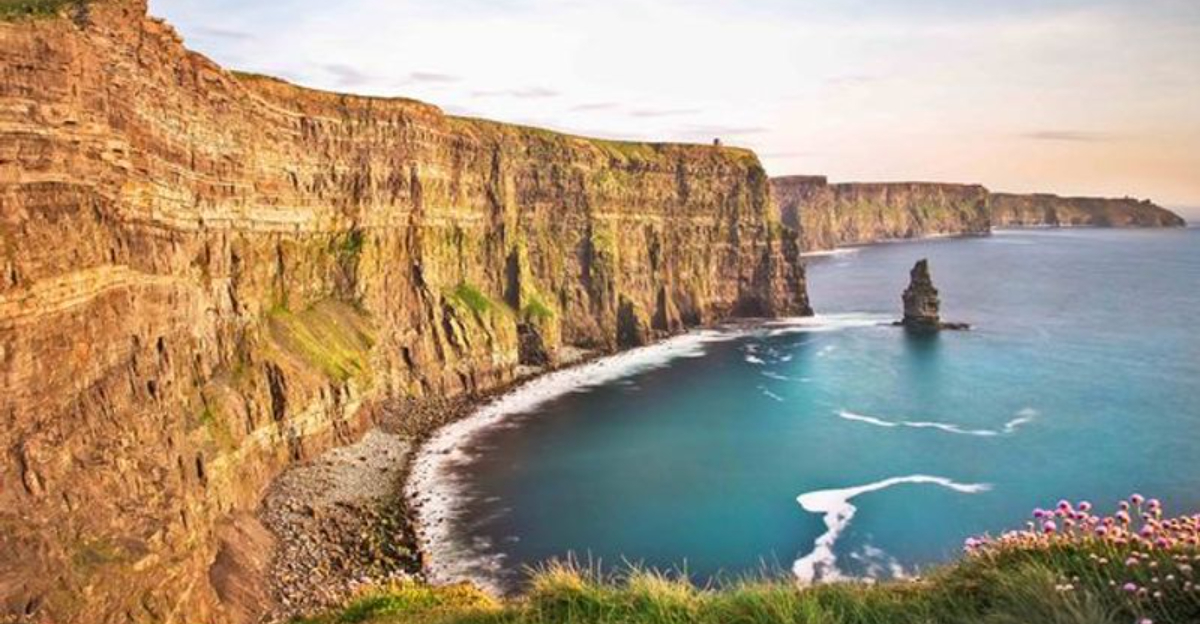
Cliffs of Moher, County Clare, Ireland

Standing at the Cliffs of Moher on a windy Atlantic afternoon is one of those travel experiences that genuinely matches the pictures. Located on the western edge of County Clare, these sea cliffs stretch for about 14 kilometers and reach heights of up to 214 meters at their tallest point near O’Brien’s Tower.
The cliffs face directly into the North Atlantic, which means the weather changes fast and the views shift dramatically throughout the day. Fog, sun, rain, and rainbows can all appear within the same hour.
Most visitors agree that the dramatic cloud conditions actually make the scenery more interesting rather than less.
O’Brien’s Tower, built in 1835 as an observation point, sits near the highest section of the cliffs and is open to visitors for a small additional fee. The main visitor center is built into the hillside to minimize visual impact on the landscape.
Puffins nest in the cliff faces from spring through early summer, adding a wildlife element that many first-time visitors do not expect to find here.
Cinque Terre, Liguria, Italy

Cinque Terre translates to “five lands,” referring to the five small fishing villages of Monterosso al Mare, Vernazza, Corniglia, Manarola, and Riomaggiore. These villages cling to the steep cliffs of the Ligurian coastline in northwestern Italy and are connected by trails, trains, and seasonal ferry services.
What makes this stretch of coastline remarkable is the combination of human settlement and raw natural terrain. The terraced hillsides, built over centuries for farming grapes and lemons, create a layered visual effect that rises dramatically from the sea.
The villages themselves are car-free, which gives the entire area a quieter, slower atmosphere compared to larger Italian coastal destinations.
The Sentiero Azzurro, or Blue Trail, is the most famous hiking route connecting the villages. Some sections require a Cinque Terre Card, which also covers train travel between the towns.
Vernazza and Manarola are widely considered the most photogenic of the five villages, particularly at the hour before sunset when the light hits the harbors from a low angle.
Big Sur, California, USA

Big Sur is not a town. It is a 90-mile stretch of California’s central coast where the Santa Lucia Mountains drop almost directly into the Pacific Ocean, leaving barely enough room for Highway 1 to thread through.
That road, officially designated a State Scenic Highway and All-American Road, is one of the most celebrated coastal drives in the world.
The Bixby Creek Bridge, completed in 1932, is the most photographed spot along the route and one of the highest single-span concrete bridges in the world at the time of its construction. McWay Falls, located in Julia Pfeiffer Burns State Park, drops 80 feet directly onto a beach that is inaccessible to visitors, making it one of the few waterfalls in California that falls into the ocean.
Big Sur has no traffic lights and limited cell service, which contributes to its reputation as one of the last genuinely remote stretches of the California coast. Pfeiffer Beach, known for its purple-tinged sand caused by manganese garnet washed down from nearby hills, is one of several beaches accessible by short unpaved roads off the highway.
Lofoten Islands, Norway

The Lofoten Islands sit above the Arctic Circle in northern Norway, and the scenery there operates on a different scale than most coastal destinations. Steep mountain peaks rise almost vertically from the sea, fishing villages are tucked into narrow inlets, and the light during summer months lasts well past midnight.
In winter, the same sky fills with the northern lights.
The islands are connected by bridges and tunnels, making them accessible by car from the Norwegian mainland via the E10 road. Svolvaer is the largest town and serves as a practical base for exploring the archipelago.
The village of Reine, set against a backdrop of jagged peaks reflected in still water, regularly appears on lists of the most beautiful villages in Norway.
Traditional red wooden fishing cabins called rorbuer, originally built for seasonal fishermen, are now rented as tourist accommodation throughout the islands. The Lofoten cod fishing season runs from January through April and remains a significant part of local culture and economy.
Hiking, kayaking, and surfing are all available depending on the season and conditions.
Faroe Islands Coastline, Faroe Islands

Located in the North Atlantic between Norway and Iceland, the Faroe Islands are an autonomous territory of Denmark made up of 18 volcanic islands. The coastline here is defined by vertical basalt cliffs, natural sea arches, and waterfalls that fall straight into the ocean from clifftops with no beach below them.
Mulafossur Waterfall near the village of Gasadalur is one of the most recognizable images from the islands, with water dropping from a high plateau directly to the sea while the village sits on the green hillside nearby. The natural arch at Drangarnir and the sea stack called Tindhólmur are accessible by boat and represent some of the most dramatic rock formations in the North Atlantic.
The Faroe Islands receive about 300 days of cloud cover per year, which shapes the landscape’s character significantly. Fog, mist, and sudden clearing skies are all part of the experience.
Sheep outnumber people on the islands, and their grazing keeps the clifftop grass cropped short, which actually improves the walking conditions along the coastal edges throughout the year.
Algarve Coast, Portugal

Portugal’s Algarve region occupies the southernmost tip of the country and offers about 155 kilometers of Atlantic coastline that ranges from wide sandy beaches backed by red and orange limestone cliffs to hidden sea caves accessible only by kayak or boat. The combination of warm weather, dramatic geology, and relatively affordable travel costs has made it one of Europe’s most visited coastal destinations.
Ponta da Piedade near Lagos is considered the most visually striking section of the Algarve coast, featuring a series of rock arches, sea stacks, and grottos carved by Atlantic waves into golden limestone. The Benagil Cave, accessible by kayak or small boat tour from Benagil Beach, is a sea cave with a domed ceiling opening that lets sunlight pour onto an interior beach.
The western Algarve near Sagres and Cape St. Vincent has a rougher, more exposed character than the sheltered eastern sections. Cape St. Vincent is the southwestern tip of continental Europe, and the lighthouse there has guided ships since the 16th century.
Surfing conditions along the western Atlantic-facing shores are strong enough to host international competitions each year.
Cape Peninsula and Chapman’s Peak Drive, Cape Town, South Africa

Chapman’s Peak Drive is one of the most technically impressive coastal roads ever built. Carved into the granite face of Chapman’s Peak along the western edge of the Cape Peninsula south of Cape Town, the road runs for about 9 kilometers with 114 curves and was blasted out of sheer cliff between 1915 and 1922.
The views over Hout Bay and the Atlantic Ocean are among the finest in southern Africa.
The Cape Peninsula itself extends south from Cape Town to Cape Point, where the Atlantic and Indian Ocean coastlines converge near the Cape of Good Hope. The Cape Point section falls within Table Mountain National Park and includes dramatic cliffs, lighthouse ruins, and large resident baboon populations that are genuinely bold around visitors.
Boulders Beach near Simon’s Town, located on the calmer False Bay side of the peninsula, hosts a colony of African penguins that can be observed from boardwalks at close range. The full peninsula circuit by car, taking in both the Atlantic and False Bay coastlines, covers roughly 150 kilometers and can be completed in a long day with stops.
Garden Route and Tsitsikamma Coast, South Africa

The Garden Route stretches along South Africa’s southern coast between Mossel Bay and Storms River, covering about 300 kilometers of coastline where temperate forest, lagoons, and rocky Indian Ocean shores meet in a landscape unlike anywhere else on the continent. The Tsitsikamma section at the eastern end is the wildest and most dramatic part of the route.
Tsitsikamma National Park protects a narrow coastal strip of indigenous forest and rocky shoreline that has been largely unchanged for centuries. The Storms River Mouth suspension bridge, one of the most visited spots in the park, crosses directly above the point where the river meets the sea through a narrow rocky gorge.
Snorkeling, kayaking, and the multi-day Otter Trail hiking route are all based here.
Knysna, roughly in the middle of the Garden Route, sits on a large lagoon protected by two sandstone cliffs known as the Knysna Heads. Plettenberg Bay offers wide sandy beaches backed by green hills.
The entire route is drivable in two to three days, but most travelers spread it over a week to allow time for the forests, beaches, and wildlife encounters along the way.
Milford Sound / Piopiotahi, Fiordland, New Zealand

Milford Sound, known in Maori as Piopiotahi, sits inside Fiordland National Park on New Zealand’s South Island and is technically a fiord rather than a sound, carved by glaciers rather than river erosion. Mitre Peak, rising 1,692 meters directly from the water, is one of the most recognized mountain profiles in New Zealand and dominates the view from the fiord entrance.
The area receives around 7,000 millimeters of rainfall annually, which feeds dozens of temporary waterfalls that appear along the cliff faces after heavy rain. Stirling Falls and Lady Bowen Falls are the two permanent waterfalls in the fiord and are visible from boat cruises that operate year-round from the Milford Sound wharf.
The Milford Road, State Highway 94, connects Te Anau to Milford Sound through 119 kilometers of mountain scenery including the Homer Tunnel, a single-lane tunnel blasted through solid rock at an altitude of 945 meters. Overnight cruises inside the fiord allow guests to kayak in the early morning when the surface is still and the reflection of the cliffs is clearest.
Dalmatian Coast, Croatia

Croatia’s Dalmatian Coast runs along the eastern shore of the Adriatic Sea for roughly 1,800 kilometers including its islands, and it combines some of the clearest seawater in the Mediterranean with a string of medieval walled towns built directly on the water’s edge. The coastline is dotted with more than 1,000 islands, islets, and reefs, giving it a fragmented, maze-like character that rewards exploration by boat.
Dubrovnik, at the southern end of the Dalmatian Coast, is the most internationally recognized destination, with its intact 14th-century city walls running along the sea cliffs above the Adriatic. Split, further north, is built directly around and inside the ruins of Roman Emperor Diocletian’s palace, which was constructed around 305 AD.
Hvar Island is known for its lavender fields and long sunny days, averaging about 2,700 hours of sunshine per year.
Island-hopping by ferry or private boat is the most popular way to explore the coast during summer. Kornati National Park, a scattered archipelago of 89 islands with almost no fresh water or permanent population, offers some of the most pristine sailing and snorkeling conditions in the entire Mediterranean region.
Turquoise Coast / Lycian Coast, Türkiye

The southwestern coast of Türkiye stretches from Bodrum to Antalya and takes its name from the remarkable color of the Aegean and Mediterranean waters that border it. Known locally as the Turquoise Coast and historically as the Lycian Coast, this stretch of shoreline combines ancient ruins, pine-covered limestone mountains, and calm bays that remain accessible mainly by boat or on foot.
The Blue Lagoon at Ölüdeniz is one of the most photographed bays in the Mediterranean, a natural lagoon protected from open-sea waves by a sandy spit. Paragliders launch from Babadag Mountain above the lagoon and land on the beach below, making the sky above as visually interesting as the water.
Butterfly Valley, accessible only by boat or a steep hike, is a narrow canyon beach that stays quiet even during peak season.
The Lycian Way is a long-distance hiking trail of about 540 kilometers that follows the coastline past ancient Lycian rock tombs carved directly into cliff faces, ruined cities, and small harbor villages. Gulet boat tours, ranging from a few days to two weeks, are a traditional way to move slowly between bays and cover sections of coast that road travel cannot reach.
Ha Long Bay, Vietnam

Ha Long Bay, located in Quang Ninh Province in northeastern Vietnam, contains roughly 1,600 limestone karst islands and islets rising from the Gulf of Tonkin. The formations were created over 500 million years of geological activity, and the result is a seascape unlike almost anything else on Earth.
The bay has been a UNESCO World Heritage Site since 1994.
Most visitors experience Ha Long Bay from the deck of a traditional wooden junk boat on overnight or multi-day cruises. These tours typically include kayaking into sea caves, visiting floating fishing villages, and exploring grottoes such as Sung Sot Cave, one of the largest in the bay, which contains dramatic stalactite and stalagmite formations lit by colored lights inside its chambers.
Lan Ha Bay, directly adjacent to Ha Long and part of the same geological system, tends to be quieter and is accessible from Cat Ba Island. Cat Ba National Park covers more than half the island and protects rare wildlife including the critically endangered Cat Ba langur.
The best weather window for visiting is generally from October through April, when rainfall is lower and visibility on the water is clearest.


