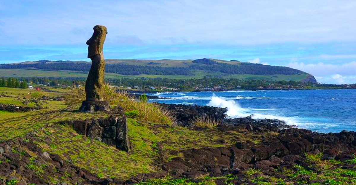
Easter Island, or Rapa Nui, sits in the southeastern Pacific Ocean more than 2,000 miles from the coast of Chile, making it one of the most remote inhabited places on the planet. Despite its tiny size, the island holds an outsized place in history, packed with stone giants, undeciphered symbols, and cultural puzzles that researchers have spent decades trying to solve.
Archaeologists, geneticists, and historians keep returning to this volcanic speck of land because every answer seems to generate two new questions. The island was first settled by Polynesian voyagers, later encountered by Dutch explorers in 1722, and has been studied intensively since the mid-20th century, yet its most compelling secrets remain stubbornly out of reach.
What follows is a close look at fifteen of the most enduring mysteries surrounding Easter Island, drawing on the latest research, oral traditions, and archaeological findings to explore what we know, what we suspect, and what continues to puzzle even the sharpest scientific minds.
1. How Were the Moai Moved?

Moving nearly 1,000 massive stone statues across a rugged volcanic island, without wheels or large domesticated animals, is the kind of engineering challenge that still stops researchers cold. The average moai weighs around 14 tons, and the largest erected statue, known as Paro, tipped the scales at roughly 82 tons.
Experiments conducted in recent decades have tested several methods. One team demonstrated that 18 people could “walk” a concrete replica of a moai upright using ropes and a controlled rocking motion, covering 100 meters in about 40 minutes.
Ancient roads on the island feature concave shapes that may have been designed specifically to support this vertical transport technique. Oral traditions also describe the statues moving through “mana,” or divine power.
No single explanation has fully closed the debate, and researchers continue to analyze road designs and statue dimensions for more clues.
2. Why Were So Many Statues Left Unfinished?

The volcanic quarry of Rano Raraku is essentially an open-air workshop frozen in time. Nearly 400 statues remain there in various stages of completion, some barely roughed out and others almost fully carved but still attached to the bedrock.
One leading theory suggests that statues intentionally left upright within the quarry were meant to stay permanently, serving as guardians of the sacred site and reinforcing the quarry’s connection to agricultural fertility. This challenges the older assumption that all unfinished moai simply represent abandoned projects.
The pattern of breakage and positioning among statues found along ancient roads also supports the idea that some fell accidentally during transport rather than being deliberately left behind. Researchers from multiple institutions continue to study the quarry’s layout, and excavations as recent as 2023 are still turning up previously uncatalogued statues embedded in the slopes.
3. What Caused the Island’s Ecological Collapse?

For decades, Easter Island served as a cautionary tale about self-inflicted environmental destruction. The standard narrative held that the Rapa Nui people chopped down every tree to move statues, triggering a collapse that ended their civilization before Europeans even arrived.
More recent research has significantly complicated that story. Ancient DNA studies published in the 2020s suggest the island’s population actually grew steadily until Peruvian slave raids in the 1860s devastated communities, rather than collapsing internally centuries earlier.
Polynesian rats, introduced accidentally by the first settlers, are now understood to have consumed up to 95 percent of the island’s tree seeds, effectively preventing forest regeneration regardless of human cutting habits. Climate-driven droughts added further pressure.
The deforestation process was gradual and multi-causal, shaped by human activity, invasive species, and shifting weather patterns working together over several centuries rather than a single dramatic event.
4. Why Were the Moai Toppled?

By the late 19th century, every single moai that had once stood on its ceremonial platform had been knocked down. When Europeans first visited in 1722, the statues were still standing.
Something changed dramatically in the intervening years.
Scholars have proposed several explanations, including inter-clan warfare, deliberate acts of political defiance against rival chieftains, and shifts in religious belief that made the old statues irrelevant or even threatening. Toppling an enemy’s ancestral statue would have carried enormous symbolic weight in Rapa Nui culture.
Historical accounts from early European visitors describe social tensions but offer no clear eyewitness explanation for when or how the toppling occurred on a large scale. The moai were typically knocked forward, breaking at the neck, which some researchers interpret as intentional desecration rather than accidental damage.
The full sequence of events behind this island-wide cultural rupture remains one of the most debated questions in Pacific archaeology.
5. What Does Rongorongo Mean?

Rongorongo is one of the rarest objects in the history of human writing. The system of carved glyphs, discovered on roughly two dozen wooden tablets in the 19th century, has resisted every serious attempt at decipherment for more than 150 years.
If confirmed as a true writing system developed independently, it would join a very short list that includes Sumerian cuneiform and Mesoamerican scripts as one of history’s few original inventions of writing. Some researchers have identified possible calendrical patterns and genealogical sequences within the glyphs, but no complete translation exists.
Oral traditions recorded by early missionaries suggest that only a small literate elite could read the tablets, and that knowledge vanished almost entirely after Peruvian slave raids in the 1860s killed or removed most of the island’s educated population. Radiocarbon dating on one tablet suggests it predates European contact, strengthening the argument for independent invention rather than borrowed influence.
6. How Did the First Settlers Reach the Island?

Reaching Easter Island required crossing one of the most open and unforgiving stretches of ocean on Earth. The nearest inhabited island sits more than 1,200 miles away, and the South American coast is over 2,300 miles to the east.
Polynesian navigators accomplished this without compasses, charts, or any modern instruments.
Linguistic analysis places the arrival of the first settlers somewhere between AD 400 and AD 800, while some archaeological evidence points toward AD 1200. Oral traditions name the founding chief as Hotu Matu’a, who arrived in large double-hulled canoes with his family and followers after being guided by a scouting expedition.
Polynesian wayfinders used star positions, ocean swells, bird flight patterns, and cloud formations to navigate. The precision required to locate such a tiny island in such a vast ocean without any landmarks is genuinely staggering, and researchers continue studying ancient canoe designs and navigation methods to understand how the journey was reliably made.
7. Why Were Some Moai Given Red Stone Hats?

Scattered around the island are large cylindrical structures made from red volcanic rock called scoria. These are the pukao, the topknots or hats that once sat atop certain moai, and they raise questions that archaeologists have been wrestling with for generations.
The pukao were quarried from a separate volcanic site called Puna Pau, miles from Rano Raraku where the statues themselves were carved. Hoisting a pukao, some weighing several tons, onto an already-erected moai would have required considerable engineering skill and coordination.
Researchers generally believe the red color and cylindrical form represent a specific hairstyle associated with high-ranking chieftains, making the pukao a marker of social status and authority. The practice of adding them appears to have begun between AD 1200 and 1300.
Some scholars also connect the red color to spiritual significance within Rapa Nui belief systems, though the precise ceremonial meaning remains a topic of ongoing discussion among specialists.
8. What Happened to the Island’s Population?

When Dutch explorer Jacob Roggeveen arrived on Easter Sunday in 1722, he encountered a functioning society with thousands of inhabitants and standing statues. The population trajectory after that point is one of the most troubling stories in Pacific history.
Peruvian slave ships raided the island in 1862 and 1863, capturing an estimated 1,500 people, including most of the island’s chiefs and religious leaders. Disease killed the majority of those taken, and the few who returned brought smallpox back with them, devastating those who had remained.
By 1877, the Rapa Nui population had dropped to approximately 111 people. Recent ancient DNA analysis challenges the older narrative of a pre-European population collapse, suggesting the community was relatively stable before outside contact.
Satellite imagery studies of rock gardens used for agriculture also indicate the island could sustainably support around 3,000 people, far fewer than some earlier estimates had claimed.
9. Why Do Some Moai Face Inland?

Visitors expecting the moai to stare dramatically out to sea are usually surprised to find the opposite. The vast majority of the island’s statues stand on coastal platforms called ahu, but they face inland toward the communities they once watched over.
This orientation is widely interpreted as intentional. The prevailing scholarly view holds that moai represented deified ancestors whose role was to protect and bless the living descendants of their clan.
Facing inland kept their gaze fixed on the people who needed their protection, rather than on the ocean.
A small group of moai at Ahu Akivi is a notable exception, facing outward toward the sea, which some researchers connect to navigation and the memory of the original voyaging ancestors. The spiritual logic behind the inland orientation is broadly agreed upon, but the full ceremonial framework that governed which direction specific statues faced and why certain exceptions exist has not been completely reconstructed from available evidence.
10. Were There Secret Caves Used During Conflicts?

Easter Island is riddled with lava tubes and natural cave formations, and the evidence inside some of them tells a story of people seeking shelter during dangerous periods. Artifacts, tools, and human remains have been found in several cave systems across the island.
Local oral traditions are specific about caves serving as refuges during warfare between rival clans, particularly during the period when the statue-building culture was breaking down and competition for resources intensified. Some accounts describe families hiding for extended periods, surviving on stored food and nearby freshwater sources.
The cave known as Ana Kai Tangata contains ancient petroglyphs connected to the Birdman cult, suggesting caves also held ceremonial significance beyond their practical uses. Systematic archaeological survey of the island’s full cave network has never been completed, meaning researchers suspect there are still cave sites with undisturbed deposits that could shed light on the nature and timeline of social conflicts during the island’s most turbulent centuries.
11. How Was the Birdman Cult Connected to the Moai?

After moai construction declined, a completely different religious system emerged on Easter Island, centered on an annual competition that determined who would hold political power for an entire year. This was the Tangata Manu, or Birdman cult, and its rise marks one of the most dramatic cultural transitions in the island’s history.
The competition required young men representing rival clan leaders to swim to the small islet of Motu Nui, retrieve the first egg of the sooty tern season, and return without breaking it. The clan whose representative succeeded earned its leader the title of Birdman, granting significant social privilege and authority.
Researchers believe the shift from statue-building to Birdman competition reflects a fundamental change in political structure, with a warrior class called Matatoa displacing the hereditary chiefs who had previously organized moai construction. Whether the transition was gradual or abrupt, and exactly what triggered it, remains a subject of active scholarly debate connecting ecology, politics, and religious change.
12. Why Are Some Moai Buried So Deeply?

Photographs of Easter Island that circulated widely throughout the 20th century often showed only the famous oversized heads of certain moai rising above the ground, which led many people to assume the statues were simply heads with no bodies. Excavations have thoroughly corrected that misunderstanding.
Full torsos, some bearing carved symbols and markings, extend several meters below the current ground surface on many statues. The burial happened gradually over centuries as soil, sediment, and organic material accumulated around the bases of statues that had been standing in place for hundreds of years.
Some researchers also point to the specific locations of deeply buried moai within the Rano Raraku quarry, where volcanic soil erodes and shifts in patterns that could accelerate burial. Ongoing excavation projects continue to document the full extent of buried moai bodies and the symbols carved on them, which may eventually reveal additional information about clan identity and ceremonial practice.
13. What Was the Purpose of the Island’s Stone Roads?

Easter Island’s ancient road network stretches across the landscape in ways that still puzzle archaeologists trying to determine their primary function. Three main road segments have been identified, converging on the Rano Raraku quarry and connecting to ceremonial sites around the island’s perimeter.
The roads feature a distinctive concave shape, with raised edges and a slightly depressed center, which some researchers argue was engineered specifically to support the rocking, upright transport of moai. The geometry would have helped keep a walking statue balanced and moving in a straight line.
Other scholars suggest the roads served broader ceremonial and social functions, acting as processional routes used during rituals rather than purely practical transport corridors. The two interpretations are not mutually exclusive.
Detailed mapping using modern ground-penetrating radar and satellite imagery is gradually revealing the full extent of the road system, including sections that were previously unknown, and the findings continue to reshape theories about how Rapa Nui society organized large-scale communal projects.
14. Did South Americans Reach Easter Island Before Europeans?

The sweet potato is a plant native to South America, yet it was a staple crop across Polynesia long before any European ship made contact with the region. That single agricultural fact has driven one of the most productive and contentious debates in Pacific archaeology for decades.
Genetic studies published in 2020 and 2021 confirmed the presence of Native American DNA in ancient Rapa Nui populations, with researchers estimating that contact between Polynesians and Indigenous South Americans occurred somewhere between AD 1250 and AD 1430. The direction of that contact, whether Polynesians reached South America or South Americans reached Polynesia, is still being worked out.
Some researchers point to similarities in stone masonry techniques between Rapa Nui construction and certain Andean architectural traditions. The evidence for trans-Pacific contact is now considered strong enough that most specialists accept it occurred, even if the full story of how, when, and how frequently remains incomplete and continues to generate new research.
15. Are There Still Undiscovered Archaeological Sites?

Despite centuries of exploration and decades of formal archaeological work, Easter Island keeps producing surprises. New discoveries have emerged regularly through the use of satellite imagery, ground-penetrating radar, LiDAR scanning, and systematic excavation programs that were not possible even twenty years ago.
Statues are still being catalogued as of 2023, and researchers believe that significant portions of the island’s interior and coastal zones have never been fully surveyed at the level of detail that modern technology now makes possible. Some ahu platforms have been found to contain structural features that were previously undetected.
The association between ahu locations and freshwater sources, identified through recent statistical analysis, suggests that the placement of ceremonial sites followed a logic tied to resource geography that researchers are only beginning to map comprehensively. Each new excavation season tends to refine or revise existing models of how Rapa Nui society was organized, making it genuinely likely that discoveries still waiting beneath the island’s soil will change the story in meaningful ways.


