Norway has a habit of making people question whether what they’re looking at is actually real. From fjords carved by ancient glaciers to waterfalls that seem to defy gravity, this country packs an almost ridiculous amount of natural beauty into one place.
I still remember scrolling through photos before my first trip and thinking someone had run everything through a heavy filter. Spoiler: they hadn’t.
These 15 natural wonders prove that Norway is basically showing off.
Geirangerfjord

Geirangerfjord has a way of making every other landscape feel a little underwhelming by comparison. The fjord stretches between walls of rock so steep and tall that waterfalls tumble off the edges like the mountains are crying with joy.
It was carved by glaciers over multiple ice ages and is now part of the UNESCO-listed West Norwegian Fjords.
The Seven Sisters waterfall is the showstopper here, a fan of seven separate streams dropping side by side down the cliff face. Tiny farms cling to ledges so narrow you wonder how anyone ever thought that was a good idea for agriculture.
Cruise ships on the water look like bath toys against the scale of the surrounding mountains.
The best views come from a boat or from the Flydalsjuvet viewpoint above the fjord. Either way, bring a camera and extra storage because you will not stop taking photos.
Nærøyfjord

Nærøyfjord wins the award for most dramatic use of narrow space in all of Scandinavia. At its tightest point, the fjord is only 250 metres wide, with cliffs shooting straight up more than 1,700 metres on either side.
It shares UNESCO World Heritage status with Geirangerfjord, and honestly, the two could not be more different in personality.
Where Geirangerfjord is wide and theatrical, Nærøyfjord feels almost secretive, like the mountains are leaning in to whisper something. The classic route is a fjord cruise between Gudvangen and Flåm, which takes you right through the heart of it.
On calm days, the water reflects the cliffs so perfectly that the whole scene looks doubled. I kept checking my photos convinced I had accidentally flipped them.
Go in the morning when the light hits the western walls and the mist is still hanging low over the water.
Lofoten Islands

Sharp mountains rising straight out of the sea is not something most coastlines can pull off, but Lofoten makes it look effortless. The islands sit above the Arctic Circle, which means summer brings nearly 24 hours of daylight and winter delivers northern lights shows over the water.
Visit Norway calls it an Arctic wilderness, and that description is not an exaggeration.
The fishing villages here are genuinely charming, with clusters of red and yellow wooden cabins perched on stilts over the water. You can eat fresh fish, rent a kayak, hike a ridge, or just stand on a beach that looks like it belongs somewhere tropical despite being in the Arctic.
Reine is often called one of the most beautiful villages in Norway, and the view from Reinebringen above it is the kind that gets printed on calendars. Plan at least three or four days here.
You will want every single one of them.
Preikestolen (Pulpit Rock)
")
Preikestolen, better known as Pulpit Rock, is a flat-topped cliff that sticks out over Lysefjord like nature decided to build its own observation deck. The drop from the edge to the water below is roughly 604 metres, which is the kind of number that makes your knees do something funny.
It is one of Norway’s most visited natural attractions, and the hike to reach it takes about two hours each way.
The trail is well-marked but involves some rocky scrambling, so decent footwear matters more than you might expect. I made the mistake of wearing slightly worn soles once and spent half the hike looking more at my feet than the scenery.
Go early in the morning, especially in summer, to beat the crowds and catch the best light over the fjord. The view from the top is genuinely one of those moments where everything goes quiet and you just stand there grinning like an idiot.
Trolltunga

Trolltunga translates to Troll’s Tongue, and once you see it, the name makes complete sense. The rock ledge juts out horizontally over Ringedalsvatnet lake, hanging about 700 metres above the water with nothing underneath it but air and a very long fall.
It is one of the most photographed spots in Norway and absolutely earns every click.
The hike is not for the faint-hearted. Depending on your starting point, it takes between 7 and 12 hours round trip, covers serious elevation, and crosses terrain that can be genuinely challenging in poor weather.
The official Trolltunga site strongly recommends checking conditions before you go and being properly equipped.
Start early, pack enough food and water, and wear layers because mountain weather changes fast. The payoff at the top is a view so surreal that most people just stand there for a while trying to process it.
Worth every blister, no question.
Kjeragbolten

Somewhere along the way, a boulder got stuck between two cliff faces above Lysefjord and became one of the most famous photo spots in Norway. That boulder is Kjeragbolten, and people queue up to stand on it for a photo with nothing but a 984-metre drop below them.
The casual confidence some people display while posing out there is either inspiring or deeply alarming, depending on your comfort with heights.
The hike to reach it is demanding, with steep sections and chains bolted into the rock to help you through the trickier parts. Visit Norway lists Kjerag alongside Trolltunga and Preikestolen as one of the country’s national scenic hikes.
Even skipping the boulder entirely, the surrounding mountain scenery is extraordinary. The Lysefjord stretches out below like a painting, and the sense of scale up there is hard to put into words.
Bring good boots, a full water bottle, and your nerve.
Jostedalsbreen National Park

Jostedalsbreen is home to mainland Europe’s largest glacier, which covers around 487 square kilometres and has been doing its thing for thousands of years. The national park surrounding it is a mix of contrasts: lush green valleys, roaring rivers, rugged mountains, and then suddenly, a wall of ancient blue ice that makes everything else look small.
The park has authorised visitor centres where you can learn about glaciers, climate change, and local wildlife before heading out. That context genuinely makes the experience richer, especially when you understand just how much these glaciers have changed over recent decades.
For anyone wanting to walk on the ice, guided glacier hikes are the only safe way to do it. Going alone onto a glacier without experience or equipment is the kind of decision that ends up in a news story nobody wants to be part of.
Stick with a certified guide and enjoy every crunchy, blue-tinted step.
Nigardsbreen Glacier

Nigardsbreen is one of the most accessible arms of the Jostedalsbreen glacier, which is a lucky thing because it is also one of the most visually striking. The blue of the ice here is almost electric, the kind of color that makes you double-check whether your camera settings are doing something weird.
They are not. It actually looks like that.
The area is protected as a nature reserve, and the visitor information explains that the landscape contains geological features including moraines, glacial scratches, and giant kettles formed by ancient meltwater. Walking through that kind of landscape feels like reading a very slow, very dramatic geology textbook.
The milky turquoise glacial lake at the base of the ice adds another layer of unreality to the whole scene. Signs and ropes mark safe zones, and guides are available for those who want to walk on the ice itself.
Follow the rules here. The glacier does not negotiate.
Vøringsfossen Waterfall

Norway has roughly 300 named waterfalls, but Vøringsfossen has a certain flair for the dramatic that puts it near the top of the list. The water drops 182 metres off the Hardangervidda plateau into the Måbødalen valley below, creating a roar you can hear well before you see it.
Norwegian Scenic Routes describes the site as having more than one kilometre of secured viewing paths.
A major upgrade to visitor facilities was completed in September 2024, adding improved parking, toilets, and charging stations. So the experience is now both spectacular and logistically smooth, which is a combination Norway does very well.
The best views come from the platforms closest to the edge, where the mist from the falls drifts up and the scale of the drop becomes fully clear. Go in spring or early summer when snowmelt pushes the volume of water to its peak.
The noise alone at that time of year is worth the trip.
Saltstraumen Maelstrom

Most natural wonders involve something you look at from a safe distance. Saltstraumen is one you can actually hear before you see it.
Located near Bodø in northern Norway, it is one of the world’s strongest tidal currents, pushing up to 400 million cubic metres of water through a narrow strait four times a day. The sea here does not flow.
It charges.
Visit Norway describes it as a unique tidal current and a must-see attraction in northern Norway. The whirlpools it creates are called maelstroms, and watching them form and dissolve in real time is genuinely hypnotic.
The current is at its most powerful during new and full moons when the tidal difference is greatest, so checking the tidal schedule before visiting is worth the effort. Fishermen love this spot because the churning water brings fish to the surface.
Everyone else loves it because it looks like the ocean is having a mild argument with itself.
Senja Island

Senja is Norway’s second-largest island, and it has clearly decided that being number two is no reason to hold back. The island splits itself almost neatly into two personalities: a gentle, agricultural interior and a wild, jagged coastline where mountains drop straight into the sea.
Visit Norway lists hiking, fishing, skiing, dog sledding, and wildlife safaris among the things you can do here.
The Senja Scenic Route runs along the western coast and passes some of the most dramatic coastal scenery in the country. The small fishing village of Husøy sits on a tiny island connected to Senja by a short bridge and looks like it was placed there specifically for postcards.
Senja gets fewer visitors than Lofoten, which means you can actually find a quiet beach or a hiking trail without company. That kind of breathing room is increasingly rare in Norway’s most scenic spots.
Come before everyone else figures this one out.
Besseggen Ridge

Two lakes, two completely different colors, and a narrow ridge between them that you have to walk along to understand why this hike is legendary. Besseggen in Jotunheimen National Park sits between the emerald-green Gjende lake and the deep blue Bessvatnet, and the contrast between them is so vivid it looks like a color-graded film still.
Visit Norway calls it one of Northern Europe’s most visited mountain ridges.
The classic route starts with a boat ride across Gjende, which is already a highlight before the hiking even begins. The ridge section itself is exposed and requires some scrambling over rocks, so this is not the place to debut brand-new hiking boots.
Henrik Ibsen once described the view from Besseggen, so you are in reasonably good literary company if you make the trip. The hike takes most people around six to eight hours.
Every single one of those hours has something worth looking at.
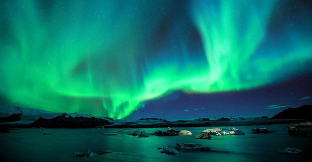
Northern Lights in Tromsø

No filter, no editing, no tricks. When the northern lights appear over Tromsø, the sky just does that on its own.
Green ribbons, purple waves, and occasional flashes of white move across the darkness in a way that makes you genuinely unsure where to look first. Visit Tromsø confirms the aurora can be seen from late August to early April, with peak viewing between 18:00 and 02:00 on clear nights.
There is no guarantee the lights will show up on any given night, which is part of what makes seeing them feel like winning something. Tromsø is one of the best-positioned cities in the world for aurora chasing, sitting right in the auroral oval where activity is most frequent.
Joining a guided tour takes you away from city light pollution and into the countryside where the skies are darker and the show is more vivid. Dress in serious layers.
Standing still in an Arctic field at midnight is cold in a way that deserves respect.
Hardangervidda Plateau

Hardangervidda is Norway’s largest mountain plateau and the largest high-altitude plateau in northern Europe, covering around 8,000 square kilometres. It is the kind of landscape that makes you feel very small in the best possible way.
Wide skies, open terrain, scattered lakes, and trails that stretch further than you can see.
The plateau is home to Europe’s largest wild reindeer herd, which makes any hike here feel like a genuine wildlife encounter rather than a scheduled attraction. The Norwegian Scenic Routes site highlights the dramatic shift between the fjord landscape below and the high plateau, particularly around the Vøringsfossen area.
Weather on Hardangervidda changes fast and without much warning, so packing layers is not optional. The plateau is popular for summer hiking and winter cross-country skiing, and both seasons offer something completely different.
If you want a landscape that feels raw, boundless, and utterly untamed, this is it. No dramatic cliffs required.
Norwegian Scenic Routes

Eighteen roads. One country.
An almost unfair amount of scenery packed into every kilometre. Norway’s Scenic Routes are a network of officially designated drives chosen specifically because the landscapes along them are extraordinary.
The official site describes them as roads running through areas with unique natural qualities, including coasts, fjords, mountains, and waterfalls.
What makes these routes special is the detail. Architects and designers have been commissioned to create rest stops, viewpoints, and toilet facilities that are genuinely worth stopping for on their own.
Some of the pit stops along these roads have won international design awards, which is not something most motorway services can claim.
Some routes close in winter due to snow, so checking conditions before planning a drive is essential. In summer, windows down and no fixed schedule is the correct approach.
These roads are not about getting somewhere quickly. They are about understanding why Norway keeps ending up on every list of the world’s most beautiful countries.


