San Francisco is surrounded by some of the most beautiful natural scenery in the country, and you do not have to travel far to experience it. Whether you are looking for towering redwoods, rugged coastlines, bay views, or quiet trails, there is a park within an hour of the city that fits the plan.
Some of these spots are well-known weekend favorites, while others fly under the radar even for longtime Bay Area residents. This list covers 15 real, currently open parks worth adding to your next day trip rotation, with details on what makes each one worth the drive.
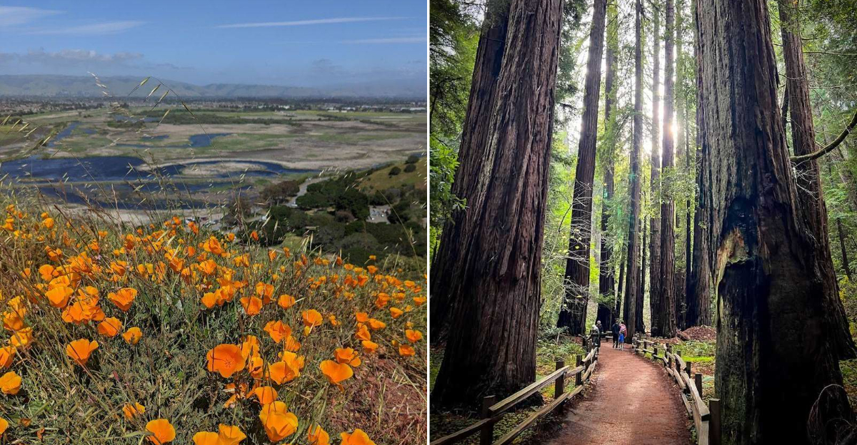
Mount Tamalpais State Park, Mill Valley, California

On a clear day, the views from Mount Tamalpais reach the Farallon Islands sitting out in the Pacific, the full spread of San Francisco Bay, the East Bay hills, and the outline of Mount Diablo. That kind of panorama from a single summit is rare, and it explains why this park draws hikers, cyclists, and photographers year-round.
The park covers a wide range of terrain, including redwood forests, oak woodlands, open grasslands, and chaparral-covered ridges. That variety means the scenery shifts noticeably as you move through different sections of the trail system.
The East Peak area is the most popular destination for summit views.
Mount Tamalpais is also the trailhead neighbor to Muir Woods below, so combining both parks into one day trip is very doable. Parking at East Peak requires a fee.
Weekends fill up fast, especially in spring and early summer when conditions are at their best.
Angel Island State Park, Tiburon, California

Getting to Angel Island requires a ferry ride, and that short trip across the water is part of what makes the experience feel like a real escape. The island sits right in the middle of San Francisco Bay, yet it carries a sense of distance that no roadside park can replicate.
California State Parks identifies it as the largest natural island in the bay.
Views from the island stretch across to the San Francisco skyline, the Marin Headlands, and Mount Tamalpais. The perimeter road and trail system let visitors circle the island on foot or by bike, with bay views opening up at nearly every turn.
Bike rentals are available on the island for those who want to cover more ground.
The history here runs deep, with layers connected to Coast Miwok stewardship, military installations, and an immigration station that processed hundreds of thousands of people in the early 20th century. Guided tours of the immigration station are available seasonally.
Marin Headlands, Sausalito, California

Just across the Golden Gate Bridge, the Marin Headlands deliver some of the most dramatic scenery in the entire Bay Area without requiring a long drive. The combination of ocean cliffs, sweeping hills, and direct views back toward San Francisco and the bridge makes this one of the most photographed areas in Northern California.
The National Park Service highlights the area’s geology, its fog-swept coastal prairie ecosystem, and the variety of history that has unfolded here across different eras. Former military batteries are scattered throughout the headlands, and many are open for exploration.
Hawk Hill is one of the most visited overlooks, sitting above the bridge with views in multiple directions. In fall, it also serves as one of the best hawk migration observation points on the West Coast.
The roads through the headlands are narrow and winding, so driving slowly and watching for cyclists and pedestrians is important. No reservations are needed for most areas.
Lands End, San Francisco, California

Lands End occupies the wild northwestern corner of San Francisco, and it genuinely feels like the edge of the city in the best possible way. Cliffside trails wind through wind-shaped cypress trees with open ocean views, and glimpses of the Golden Gate Bridge appear through the branches as you move along the path.
This section of the Golden Gate National Recreation Area carries a layered history. The Golden Gate National Parks Conservancy connects it to Ohlone history, early fishing grounds, shipwrecks visible at low tide, and the remnants of old coastal attractions that no longer exist.
Those traces of the past give the trail an interesting texture beyond just the scenery.
The Lands End Lookout visitor center is a good starting point, with parking, restrooms, and trail maps available. The main coastal trail is roughly 3.5 miles round trip and stays mostly flat.
No reservations are needed, and there is no entrance fee for this section of the recreation area.
Muir Woods National Monument, Mill Valley, California

Walking among coast redwoods that have stood for hundreds of years is a genuinely humbling experience, and Muir Woods puts that experience less than 30 minutes from San Francisco. The trees here are among the tallest living things you will encounter anywhere near a major American city, and the forest floor stays cool and shaded even on warm days.
The park is open daily, but visitors must plan ahead. Parking and shuttle reservations are required before you arrive, which means you cannot simply show up and expect a smooth entry.
Booking in advance through the National Park Service reservation system is the standard move.
The main trail along Redwood Creek is paved and relatively flat, making it accessible for most visitors. Side trails lead deeper into the forest and up the hillsides for those who want more elevation.
Entrance fees apply, so check the current rates before heading out.
Crissy Field, San Francisco, California

Few places in San Francisco give you this much open waterfront space with this little effort to reach it. Crissy Field sits along the northern edge of the Presidio, and from almost anywhere along its path, the Golden Gate Bridge fills the view ahead.
It is the kind of place where a simple walk turns into something genuinely memorable.
The Presidio describes the area as offering beaches, picnic areas, open lawns, and room for walking and biking with direct bridge views throughout. The restored tidal marsh on the western end adds a quieter, wildlife-friendly stretch to the experience.
Shorebirds are commonly spotted along that section.
Parking is available along Mason Street and in nearby Presidio lots, though weekend mornings fill up early. The area is flat and accessible, making it a comfortable option for families, casual walkers, and anyone looking for a relaxed outdoor afternoon.
No admission fee is required to access Crissy Field.
Presidio Tunnel Tops, San Francisco, California

Presidio Tunnel Tops opened in 2022 and quickly became one of the most talked-about new parks in San Francisco. Built over the Presidio Parkway tunnels, the 14-acre space transformed what was once a traffic corridor into a polished, free public park with direct Golden Gate Bridge views and serious playground infrastructure.
The Golden Gate National Parks Conservancy describes it as a starting point for national park adventures, and the design reflects that ambition. Trails connect to the broader Presidio trail network, picnic areas are well-distributed across the lawn space, and the main playground is widely considered one of the best in the city.
Families with young children tend to make this a destination on its own, while hikers and photographers use it as a launch point for longer Presidio routes. Parking is available in the Presidio, though the tunnel tops area itself is car-free.
Admission is free, and the park is open daily during daylight hours.
Mori Point, Pacifica, California

Mori Point sits just south of San Francisco along the coast of Pacifica, and it delivers ocean views that feel far more remote than the short drive suggests. The National Park Service describes it as a 110-acre promontory with panoramic views stretching from Point Reyes in the north to Pedro Point in the south.
On a clear day, that is a significant slice of the California coastline visible from one spot.
The park has an interesting backstory worth knowing. Before it was added to the Golden Gate National Recreation Area, the land had been damaged by quarrying operations and off-road vehicle use.
Restoration work has since brought native plants and wildlife back to the bluffs, and the recovery is visible in the vegetation covering the hillsides today.
Two main trails access the bluff, one lower and one upper, and both are relatively short and manageable. The upper trail offers the most open views.
Parking is available off Bradford Way in Pacifica, and there is no entrance fee.
San Bruno Mountain State And County Park, Brisbane, California

San Bruno Mountain rises just south of San Francisco and offers something that surprises a lot of first-time visitors: genuinely open, rugged terrain within sight of the city. California State Parks places the park at the northern reaches of the Santa Cruz Mountains, and the ridge trails back that up with sweeping views over San Francisco, the Bay, and the peninsula below.
San Mateo County Parks lists the park as opening daily at 8:00 a.m., with closing times that shift by season, so checking current hours before visiting is a smart move. The trail system ranges from easy loop walks to longer ridge routes with more elevation gain.
Spring is a particularly good time to visit, when the hillsides turn green and wildflowers appear across the open slopes. The park is also home to several rare and endangered butterfly species, including the San Bruno elfin butterfly, which is tied to specific native plants found only in this area.
Parking fees apply.
Dr. Aurelia Reinhardt Redwood Regional Park, Oakland, California

For anyone who wants the redwood forest experience without navigating the Muir Woods reservation system, Reinhardt Redwood Regional Park in Oakland is a genuinely strong alternative. East Bay Regional Park District describes it as a redwood forest just a few miles over the ridge from downtown Oakland, where coast redwoods now reach around 150 feet tall after the original forest was logged heavily in the mid-1800s.
The regrowth is impressive. Walking through the park, it is easy to forget that these trees are second-growth rather than old-growth, because the canopy is dense and the forest floor stays cool and quiet.
Creekside trails run through the lower sections of the park, adding a gentle water element to the walk.
The park connects to a larger regional trail network, so it can serve as a short nature break or a longer hiking day depending on your energy level. No reservations are required, and the park is free to enter on foot.
Parking fees apply at most trailheads.
Charles Lee Tilden Regional Park, Berkeley, California

Tilden Regional Park is one of those East Bay classics that has been a family favorite for generations, and it still holds up well today. The park covers over 2,000 acres in the Berkeley Hills and packs in more variety than most parks twice its size, with options ranging from swimming at Lake Anza to riding a vintage steam train through the trees.
East Bay Regional Park District lists current facilities including the Brazilian Room, a botanic garden dedicated to California native plants, the Little Farm where kids can interact with animals, and seasonal swimming at Lake Anza. The merry-go-round near the main picnic area is a longtime crowd favorite for families with younger children.
The trail system moves through wooded canyons and up to open ridge lines, so the scenery shifts noticeably depending on which direction you head. Tilden connects to neighboring parks for longer routes.
Most facilities have their own seasonal hours, so checking before you go saves time at the gate.
Coyote Hills Regional Park, Fremont, California

Coyote Hills Regional Park sits along the eastern shore of San Francisco Bay near Fremont and Newark, and its combination of open hills and bayfront marshland makes it feel distinct from most other regional parks in the area. East Bay Regional Park District notes the park was dedicated in 1967 and covers 1,266 acres, with room for hiking, jogging, cycling, bird watching, and picnicking across its varied terrain.
The marsh areas are especially productive for bird watching. The wetlands along the bay edge attract shorebirds, waterfowl, and migratory species throughout the year, and the flat trails through those sections are easy to walk at any pace.
The hills above the marsh offer elevated views across the bay toward the San Francisco Peninsula.
Coyote Hills also has an archaeological history connected to the Ohlone people, and the park includes interpretive displays about that past. A visitor center on site provides maps and natural history information.
Parking fees apply at the main entrance off Patterson Ranch Road.
China Camp State Park, San Rafael, California

China Camp State Park occupies a quiet stretch of Marin County bayfront that most people drive past without knowing it exists. The park combines wooded trails, open grassland, picnic areas, and bay access along San Pablo Bay, giving visitors a low-key alternative to the busier parks further south.
California State Parks notes that Friends of China Camp operates the park under contract, relying on volunteer service and donations to keep it functioning.
The historic shrimping village at China Camp Point is one of the more unusual features you will find in any Bay Area state park. The preserved structures date to the late 1800s and represent a significant chapter in the history of Chinese fishing communities in California.
A small museum on site provides context for what you are looking at.
Day-use areas including Buckeye Point and Weber Point offer waterfront access and views along the bay. The trail system covers around 15 miles and suits both casual walkers and mountain bikers.
Parking fees apply at the day-use areas.
Half Moon Bay State Beach, Half Moon Bay, California

Half Moon Bay State Beach stretches roughly two linear miles along the San Mateo County coast, from Kelly Avenue north to Mirada Road, according to the City of Half Moon Bay. That is a lot of open beach to walk, and the setting is straightforward in a way that is actually refreshing: wide sand, coastal views, and the kind of sea air that clears your head quickly.
California State Parks currently notes that project work at Roosevelt Beach is scheduled to begin April 1, 2026, continuing on weekdays for approximately three months. Visitors planning trips around that window should check conditions before heading out, since construction activity may affect access in that section of the beach.
The town of Half Moon Bay itself adds to the appeal of making a day of it. Coastal restaurants, a farmers market, and the historic Main Street area are all within easy reach of the state beach parking lots.
Parking fees apply, and the lots can fill on sunny weekends.
Point Pinole Regional Shoreline, Richmond, California

Point Pinole Regional Shoreline is one of the least crowded bay-access parks in the entire region, and that low profile is a genuine advantage. East Bay Regional Park District describes it as a 2,432-acre parkland bordering the communities of Pinole, Richmond, and San Pablo, with a mix of marshes, meadows, eucalyptus groves, and open shoreline paths that offer expansive bay views throughout.
The fishing pier at the tip of the point is a popular destination for anglers, and the park provides a free shuttle from the main parking area to the pier on weekends and holidays, which makes the longer walk optional rather than required. The trail network covers enough ground to support a half-day outing without any backtracking.
Wildlife sightings along the marsh edges are common, including shorebirds, raptors, and the occasional harbor seal offshore. The park is open daily, with parking fees applying at the main lot off Giant Road in Richmond.
No reservations are needed for general day-use access.


