Some American towns sit at the end of a route so completely that maps almost look unfinished. These places were shaped by ferries, highways, border crossings, fishing grounds, tourism booms, and the simple fact that you cannot keep driving past them.
That hard stop changes everything, from how groceries arrive to how visitors remember the trip. Keep reading and you will get a lively tour of fifteen towns where geography, infrastructure, and local identity all meet at the final strip of pavement.
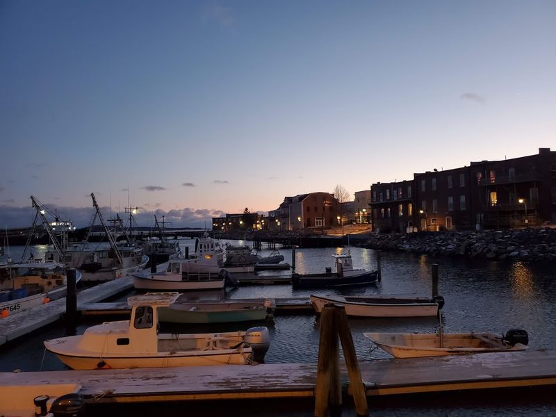
1. Key West, Florida
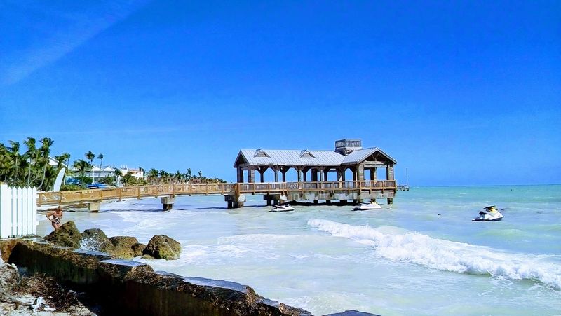
Here, the highway finishes with the confidence of a punchline. Key West marks the southern end of U.S. 1, the route that threads down the Florida Keys by way of the Overseas Highway, a 20th century engineering feat built partly atop the old Florida East Coast Railway corridor.
That final approach matters because it turned a once harder-to-reach island into a national destination after the 1930s highway era replaced earlier rail service. The town grew into a layered place shaped by Cuban connections, naval activity, cigar making, wrecking history, and an arts scene that long outlasted any novelty attached to the mile marker.
You arrive knowing there is no next exit to another island city of equal size. That fact gives Key West its particular rhythm: cruise visitors, winter residents, day trippers, and locals all meeting where American pavement officially runs out.
2. Barrow (Utqiaġvik), Alaska

This is the kind of place that makes a road map admit its limits. Utqiaġvik, long known as Barrow, sits on Alaska’s North Slope beside the Arctic Ocean, and no highway connects it to the rest of the American road network.
That isolation is not a gimmick but a practical reality shaped by climate, tundra conditions, and the cost of building permanent overland routes across vast distances. Within town, roads serve neighborhoods, schools, public buildings, and work sites, then stop at shoreline, permafrost, or open land, reinforcing that this community developed through Inupiat continuity and modern air access rather than through interstate driving culture.
Its role as the northernmost U.S. community gives it symbolic weight, but the place is more than a geographic superlative. Research activity, subsistence traditions, municipal services, and Arctic policy discussions all converge where the pavement ends and the continent becomes mostly ice, water, and weather.
3. Haines, Alaska
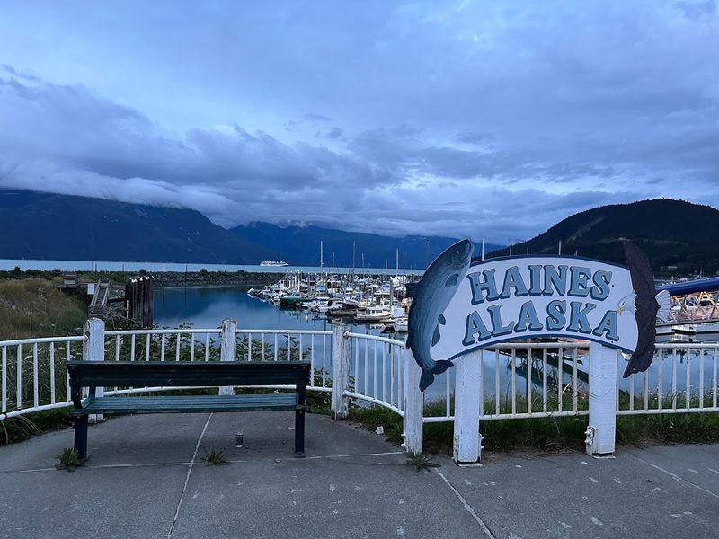
The road into Haines feels like it signed a contract with geography and then ran out of clauses. The Haines Highway links the town to Canada and the Alaska Highway system, but the route’s final stretch emphasizes just how abruptly mountains, inlets, and limited flat land define local movement.
Haines developed as a strategic and commercial point tied to Indigenous history, mission activity, military interests, and later transportation links serving the Lynn Canal region. Unlike places built around through traffic, it functions as a terminus town, where ferries, small-boat activity, and seasonal visitors matter as much as the road itself, because there is no endless grid beyond the harbor and valley.
That endpoint status shapes the town’s personality in practical ways. Freight planning, tourism pacing, and even casual day trips all revolve around schedules, weather, and terrain, which gives Haines a grounded, slightly stubborn sense of being exactly where access stops getting easy.
4. Homer, Alaska
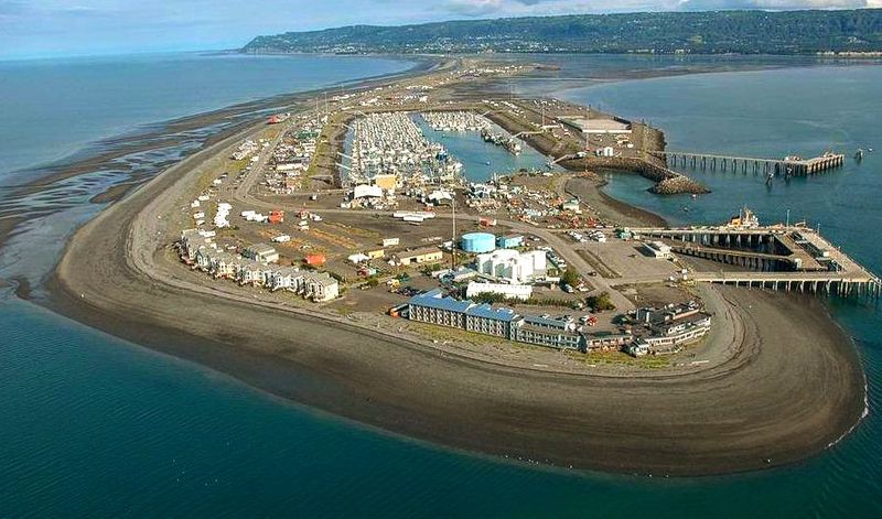
Few towns advertise their position with such cheerful bluntness. Homer is widely called the end of the road because the Sterling Highway terminates here, then hands the narrative over to the Homer Spit, that famously narrow strip projecting into Kachemak Bay.
The modern road connection helped transform Homer from a coal shipping and fishing settlement into a regional service center with tourism, art, mariculture, and charter businesses. Yet the terminus still matters because traffic does not simply pass through on its way elsewhere; it accumulates, pauses, launches into the bay, or turns around after reaching one of Alaska’s most recognizable dead ends.
You can see how that pattern shaped development. Harbor facilities, tackle shops, galleries, lodging, and local institutions all grew around the fact that Homer is both a final stop for motorists and a jumping-off point for water taxis, fishing grounds, and communities across the bay where roads do not continue.
5. Lubec, Maine
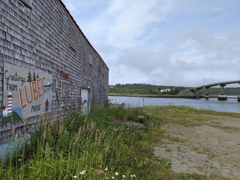
Morning arrives early here, and the map gets very definite. Lubec sits at the eastern edge of Maine, reached by Route 189, a road that narrows the state’s broad geography into one final destination near Passamaquoddy Bay.
The town’s location fostered trade, fishing, sardine packing, and cross-border ties with nearby Campobello Island, while its remoteness limited the sort of casual through traffic that reshapes many coastal communities. Once the road ends, water and international boundaries take over, which means Lubec has long balanced local industry, seasonal tourism, and the routines of a borderland rather than those of a standard highway town.
That distinction gives the place unusual clarity. You are not there by accident, and historically neither were merchants, cannery workers, lighthouse keepers, or visitors drawn by the easternmost claim, the rugged coast, and the practical fact that the pavement really has reached its eastern conclusion.
6. Terlingua, Texas

The pavement starts sounding less confident before you even arrive. Terlingua lies near the western edge of Texas close to Big Bend, where maintained roads give way to a harsher network shaped by mining history, ranch land, and protected desert terrain.
Its story centers on quicksilver mining, especially in the late 19th and early 20th centuries, when cinnabar deposits made the area economically significant despite difficult transport conditions. After mining declined, Terlingua shifted from company-town practicality toward a mix of sparse residency, tourism, historic preservation, and gateway traffic for Big Bend National Park, all while keeping the unmistakable feeling that the road has stopped making promises.
That endpoint quality is less about a famous highway marker and more about how infrastructure thins out into distance. Visitors arrive for desert scenery and ghost town lore, but they also encounter a useful lesson in western settlement: roads only continue when commerce, terrain, and maintenance budgets agree.
7. Stehekin, Washington
This town skips the whole highway concept and still makes the list easily. Stehekin sits at the head of Lake Chelan inside a remote North Cascades valley, accessible by boat, plane, or trail, with local roads that serve only short stretches before forest and public land take over.
Its history includes Native presence, mining attempts, homesteading, tourism, and later incorporation into the recreational geography of Lake Chelan and the national park complex nearby. Because there is no through road, local infrastructure evolved around docks, lodges, limited vehicle use, and seasonal service patterns rather than around gas-station convenience culture, which gives Stehekin a practical kind of isolation rather than a theatrical one.
The place feels final because every arrival already includes a decision against convenience. Once there, roads perform modest jobs like linking the landing, bakery, ranch areas, and trailheads, then stop without apology, leaving visitors to accept that in some American communities, transportation remains refreshingly non-automotive.
8. Supai, Arizona
The road gives up long before the town appears, which is the whole point. Supai, the main village of the Havasupai Tribe inside the Grand Canyon, is famously not connected by road to the outside world, so the endpoint is really the trailhead far above the settlement.
That absence of road access has preserved a transportation pattern based on hiking, pack animals, and helicopter service for certain needs rather than ordinary car traffic. It also means every supply decision, visitor plan, and infrastructure upgrade has to respect canyon geography, tribal governance, and the reality that modern convenience arrives differently here than in roadside communities.
Calling Supai an end-of-road town is accurate, but incomplete. It is better understood as a place where the American assumption of universal road access simply does not apply, and where settlement continuity, tourism management, and daily life all operate according to terrain first, with the nearest pavement serving as a boundary rather than a welcome mat.
9. Port Orford, Oregon
Some coastal towns feel like pauses, but this one feels like a period. Port Orford sits on Oregon’s southern coast where Highway 101 still continues in theory, yet the town’s scale, topography, and working harbor create a convincing sense that the journey has reached a practical edge.
Founded in the 1850s and shaped by port ambitions, fishing, timber, and maritime trade, Port Orford developed under conditions that never encouraged oversized growth. Its famously distinctive harbor operations, including the long-running use of cranes to lift boats, reflect local geography and weather realities, and they reinforce the idea that standard infrastructure has always needed adaptation here.
Even without a formal highway terminus sign, the town belongs on this list because it embodies road’s-end psychology. Southbound travelers encounter fewer urban interruptions, more headlands, and a community where commerce feels attached to the ocean and the land’s constraints, not to endless inland expansion or suburban overflow.
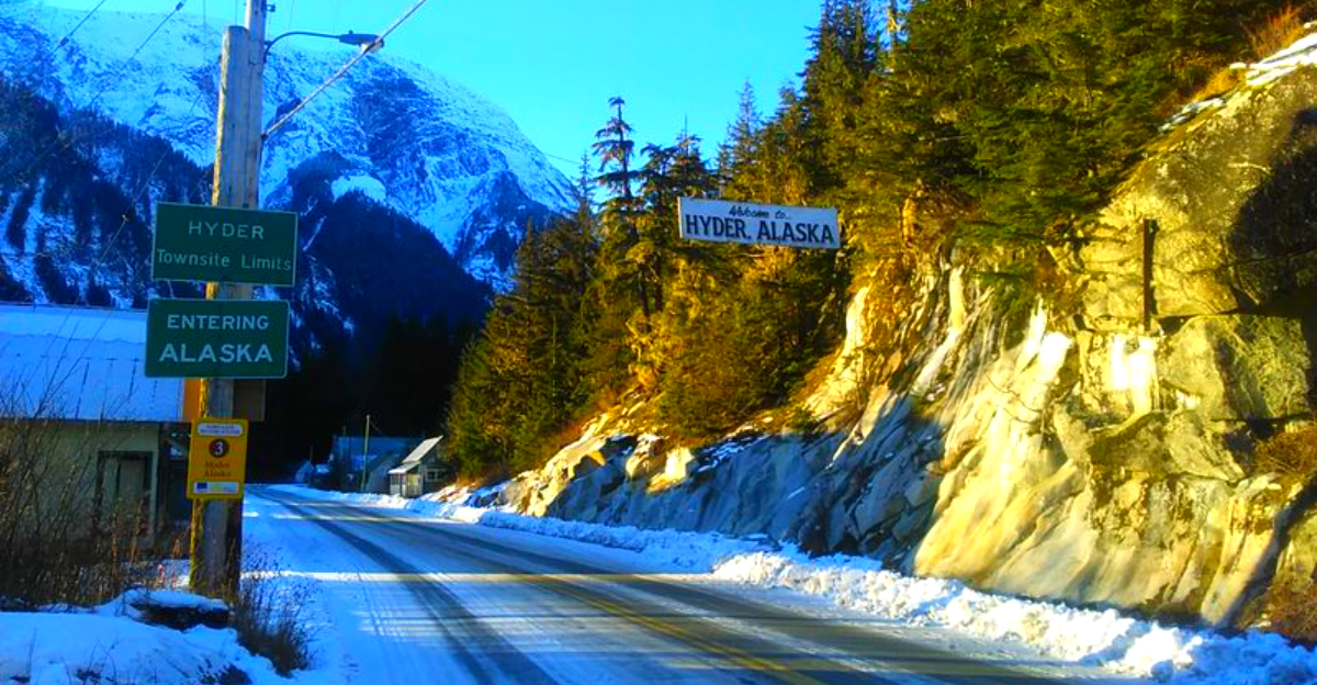
10. Hyder, Alaska
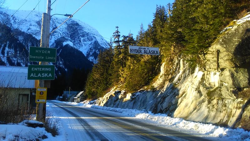
If a town could shrug at the concept of passing traffic, Hyder would do it. This tiny Alaska community is reached by road only through British Columbia, and beyond it the landscape quickly turns into protected land, mountains, and very limited human infrastructure.
Hyder emerged in the early 20th century during regional mining activity and served as an access point for nearby claims, freight movement, and borderland commerce. Its unusual position means that even routine travel involves an international crossing, a detail that instantly separates it from most American towns and gives its dead-end character a bureaucratic twist on top of the geographic one.
That combination has kept Hyder small, memorable, and slightly legendary among road trippers who enjoy terminus culture. You arrive because you intend to, not because a GPS found a shortcut, and once there the town’s scale, isolation, and one-way geography make the notion of continuation seem almost administratively unnecessary.
11. Cape May Point, New Jersey
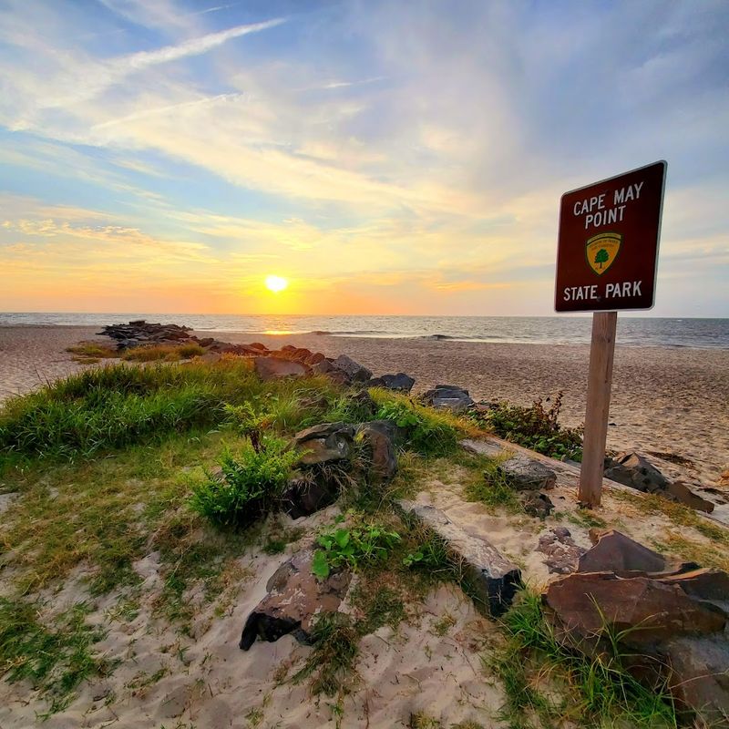
The state runs out of confidence and then hands things over to the sea. Cape May Point occupies the southern tip of New Jersey, where local roads narrow toward beaches, the Cape May Lighthouse, dunes, and protected natural areas instead of continuing into another chain of towns.
Its development followed a different rhythm from boardwalk-heavy resort communities farther north. Bird migration, lighthouse history, coastal defense remnants, summer cottages, and conservation policies have all shaped the borough, producing a place where the end of the road feels less commercial than geographic, even though tourism still plays a visible role.
That distinction is what makes Cape May Point so interesting in this lineup. The endpoint is not remote in the Alaskan sense, but it is decisive, because drivers eventually meet beach access, refuge land, and open water rather than another suburban corridor, and the town’s identity has been built around that literal and psychological southern conclusion.
12. Grand Portage, Minnesota
The map pinches tightly up here, as if Minnesota is making a final point. Grand Portage sits near the far northeastern corner of the state along Lake Superior, where Highway 61 reaches one of its last American communities before the Canadian border and the road network thins dramatically.
Long before pavement, this was a crucial Indigenous and fur-trade corridor, with the grand portage itself serving as a major carry route around challenging river access. Today the area’s identity includes Ojibwe community life, the Grand Portage National Monument, borderland logistics, and a scale of settlement that never pretended to support broad suburban spread.
That gives the town an endpoint character rooted in centuries of movement, not just modern motoring. Travelers arrive at a place where transportation history shifts from canoe routes and trading posts to scenic highway travel and cross-border proximity, then essentially stops, leaving Lake Superior, forest, and protected landscapes to take over the conversation.
13. Seldovia, Alaska
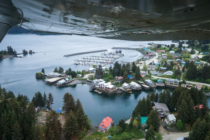
Cars are useful here right up until the town reminds them who is in charge. Seldovia sits across Kachemak Bay from Homer and has no road connection to the larger Alaska highway system, so boats and planes remain essential even though local streets handle everyday movement within town.
Russian influence, Alaska Native history, commercial fishing, and shifting waterfront design all shaped Seldovia’s compact form. Because the community occupies a constrained coastal site, roads and boardwalks often terminate at docks, shoreline structures, or steep terrain, giving the town a very literal sense of streets ending where marine access begins.
That pattern says a lot about how settlement adapts when regional connectivity depends more on tides, schedules, and vessel capacity than on long-distance driving. Seldovia does not merely sit off the main road; it operates in a transportation system where the road is a local tool, not the master framework for reaching the outside world.
14. Eastport, Maine
By the time you reach Eastport, Maine has become very serious about edges. The town occupies Moose Island near the Canadian border, and the roads that bring you there feel less like connectors to somewhere bigger and more like a deliberate funnel toward one of the country’s eastern extremes.
Eastport built its importance through shipping, fishing, sardine canning, and border trade, with the Bay of Fundy tides constantly influencing harbor life and waterfront infrastructure. Those enormous tidal ranges are not just scenic trivia; they affect docks, work routines, and how the town understands itself as a place where land transportation remains secondary to maritime realities.
That is why Eastport belongs among true road’s-end communities. The route finishes in a working island town whose economy and history were never fully organized around highways, and the result is a place where visitors confront a useful fact: pavement may deliver you, but water still sets the terms.
15. Hana, Hawaii
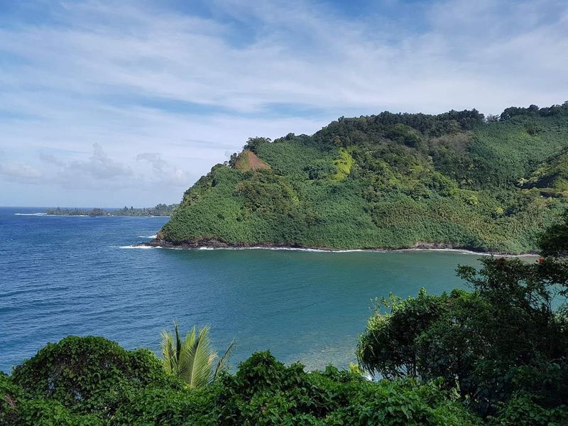
The journey is so famous that arrival can feel almost secondary, until you notice the road really does stop. Hana, on Maui’s eastern side, is reached by the Hana Highway, a route known for its narrow passages, bridges, and curves that limit speed and shape every visitor’s expectations.
Historically, Hana was more connected by coastal travel and local agriculture than by easy overland driving from Maui’s larger population centers. Even after modern road improvements, the route remained a controlling factor, preserving a degree of separation that influenced tourism patterns, daily logistics, and the town’s smaller-scale development compared with resort-heavy parts of the island.
That makes Hana an excellent example of a road’s-end destination that is famous without becoming generic. You do not drift into it casually, and once there the Pacific, the surrounding landscape, and the limits of infrastructure make clear that the celebrated drive was not just a scenic prelude but the defining fact of access itself.


