Most travelers have a go-to list: Yellowstone, the Grand Canyon, maybe a beach in Florida. But the U.S. is packed with jaw-dropping spots that never make it onto those lists.
I stumbled onto one of these hidden gems by accident years ago, and it completely changed how I travel. These 16 places deserve a spot on your radar, and trust me, you’ll wonder why you waited so long.
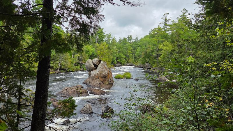
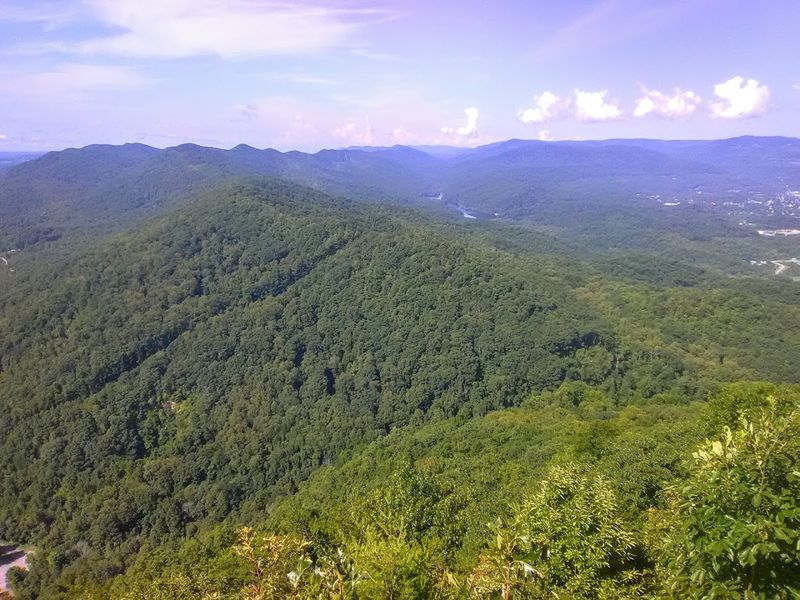
Black Canyon of the Gunnison National Park, Colorado
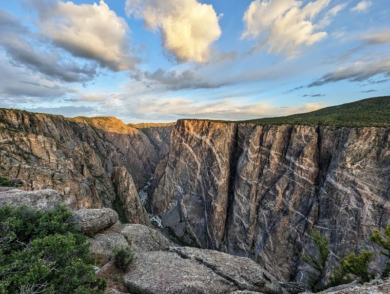
Some canyons are wide and welcoming. Black Canyon of the Gunnison is neither, and that’s exactly the point.
The walls here drop over 2,700 feet and are so narrow that some sections receive only 33 minutes of sunlight per day.
The dark Precambrian rock gives the canyon its moody, almost gothic atmosphere. Standing at the South Rim feels genuinely dramatic.
You’re peering into one of the deepest, steepest canyons in North America, and it hits differently than the Grand Canyon’s wide-open vistas.
Most visitors are surprised to learn the park is just 15 minutes from the town of Montrose, Colorado. It’s not remote, but it still draws a fraction of the crowds that bigger parks see.
Fishing in the Gunnison River below is legendary among fly fishing fans. Bring your camera, solid shoes, and maybe a healthy respect for heights.
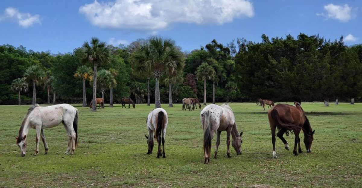
Cumberland Island National Seashore, Georgia
Wild horses wandering past crumbling mansion ruins on a deserted beach sounds like a scene from a novel. At Cumberland Island, it’s just a Tuesday.
Georgia’s largest barrier island is only reachable by ferry, which keeps it blissfully crowd-free.
The island has no cars, no hotels, and no fast food. Just 17 miles of undeveloped Atlantic coastline, ancient live oaks draped in Spanish moss, and around 200 feral horses that have roamed here for centuries.
The ruins of the Carnegie family’s Dungeness mansion add a haunting, storybook quality to the whole place.
Camping is the main accommodation option, and reservations fill up fast. The ferry runs from St. Marys, Georgia, and tickets sell out weeks in advance during peak season.
Pack everything you need because there are zero shops on the island. It’s the kind of place that makes you question why you ever bothered with crowded resorts.
Chiricahua National Monument, Arizona
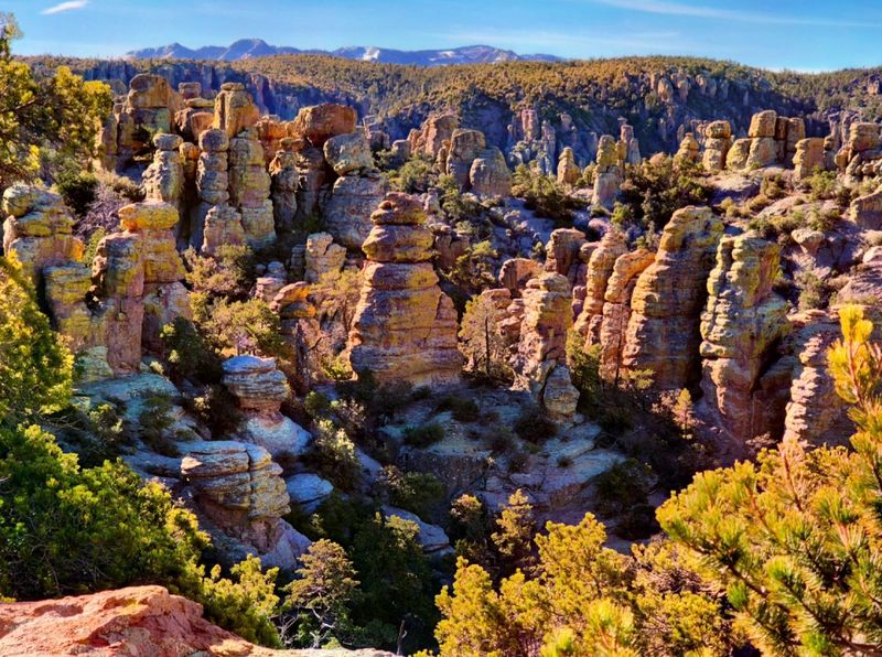
Nicknamed the “Land of Standing Up Rocks” by the Apache people, Chiricahua National Monument looks like someone stacked boulders the size of houses and then walked away. The geology here is genuinely bizarre in the best possible way.
Volcanic eruptions 27 million years ago created the rhyolite rock, and erosion slowly carved it into the surreal spires and balanced rocks you see today. The 8-mile Bonita Canyon Drive winds through the monument and offers pullouts at some seriously photogenic spots.
Hiking trails range from easy walks to full-day adventures through the rock columns.
This corner of southeastern Arizona sits in what was once Cochise’s stronghold, and the history here is just as compelling as the scenery. Wildlife sightings include coatimundis, white-tailed deer, and over 170 bird species.
The monument is about 120 miles southeast of Tucson. It’s far enough off the highway to feel truly remote.
Mojave National Preserve, California
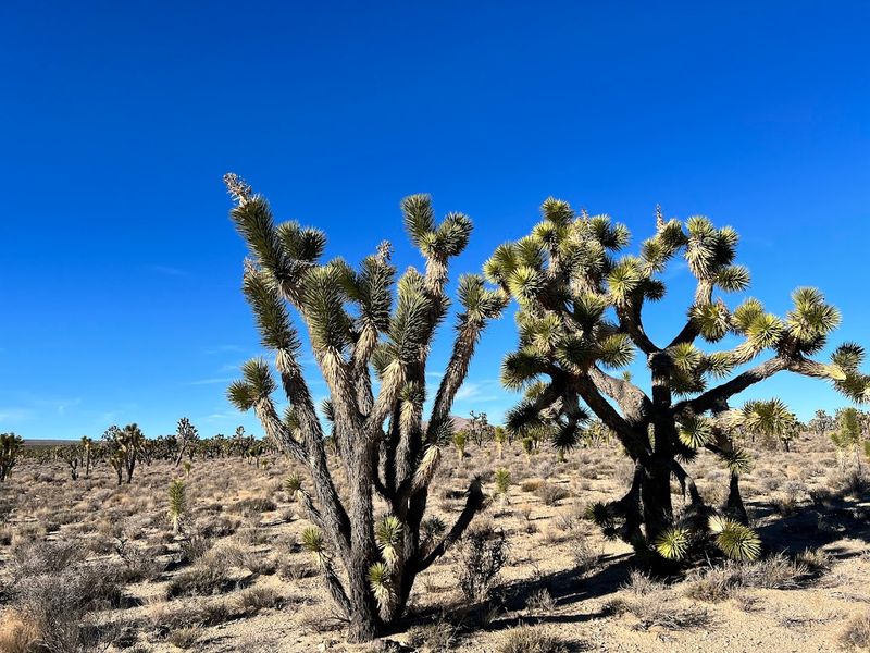
Sandwiched between Death Valley and Joshua Tree, Mojave National Preserve gets overlooked by visitors rushing between its famous neighbors. That oversight is their loss and your gain.
The preserve covers 1.6 million acres of desert that almost nobody talks about.
Kelso Dunes rise 650 feet and are known for a rare phenomenon called singing sand, where the grains produce a low rumbling sound when disturbed. The Cima Dome area holds one of the densest Joshua tree forests on Earth.
Volcanic cinder cones, lava tubes, and abandoned railroad towns round out the weirdly wonderful landscape.
I once had the entire Kelso Dunes trailhead parking lot to myself on a Saturday in October. That kind of solitude in California is practically a miracle.
The preserve has no entrance fee, which is another reason to love it. Bring plenty of water, a paper map, and a willingness to get pleasantly lost.
Devils Postpile National Monument, California
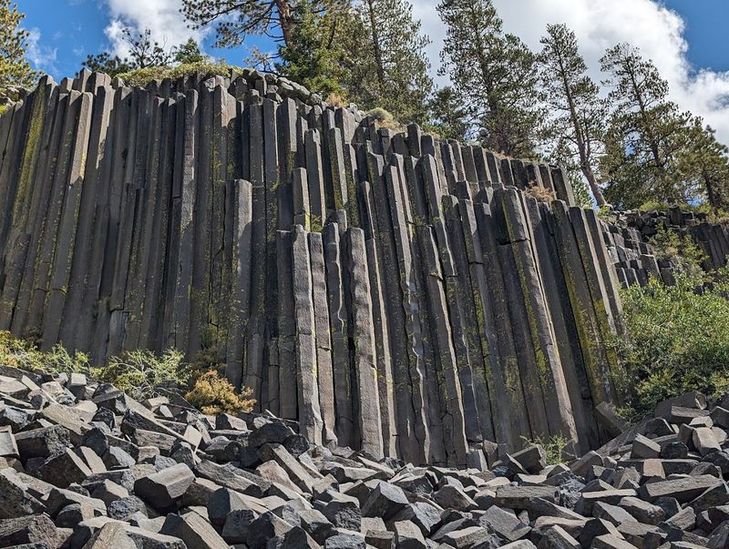
Geometry class never prepared me for Devils Postpile. These near-perfect hexagonal basalt columns, formed by cooling lava roughly 100,000 years ago, look less like nature and more like an architect’s fever dream.
They stand up to 60 feet tall.
Located in the Sierra Nevada near Mammoth Lakes, the monument is only accessible by shuttle during summer, which actually keeps visitor numbers manageable. The short hike to the postpile itself is easy, making it accessible for most fitness levels.
From the top, you can see the geometric honeycomb pattern of the column tops, which is genuinely mind-bending.
Rainbow Falls, a 101-foot waterfall just a mile downstream, makes an excellent add-on to the trip. The whole area sits at about 7,600 feet elevation, so altitude can sneak up on you.
Plan to arrive early in the morning before shuttle lines form. This one is small but absolutely worth the detour from Mammoth Mountain.
Cedar Breaks National Monument, Utah
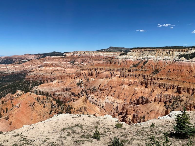
Utah has Bryce Canyon. Utah also has Cedar Breaks, which looks almost identical but sits at 10,000 feet elevation and draws a tiny fraction of the crowds.
The natural amphitheater here stretches three miles wide and drops 2,000 feet into a kaleidoscope of orange, red, and purple hoodoos.
The colors at Cedar Breaks are arguably more vivid than those at Bryce. Iron and manganese in the limestone create a painterly effect that photographers absolutely love.
The short season, typically June through October due to snow, keeps annual visitor numbers low. That’s your window.
The monument sits along Highway 148 in southern Utah, about 60 miles from Zion National Park. Wildflower season in July is spectacular, with alpine meadows bursting with color above the canyon rim.
Stargazing here is excellent thanks to the high elevation and minimal light pollution. Cedar Breaks is proof that the best views sometimes come without the parking nightmare.
John Day Fossil Beds National Monument, Oregon

Oregon’s high desert hides one of the world’s most important fossil records, and almost nobody outside the paleontology community seems to know it exists. John Day Fossil Beds spans three separate units across a wide swath of central Oregon, each with a completely different look.
The Painted Hills unit is the showstopper. Striped mounds of red, gold, black, and tan roll across the landscape like something from another planet.
The colors come from ancient soil layers laid down over millions of years. Fossils found here include prehistoric horses, camels, and rhinos that once roamed this part of North America.
The town of John Day serves as a decent base camp, with a few motels and diners. The Thomas Condon Paleontology Center at the Sheep Rock unit offers free exhibits and real fossils on display.
No crowds, no entrance fee, and scenery that makes your jaw drop. Pack a picnic and spend a full day exploring all three units.
Bandelier National Monument, New Mexico
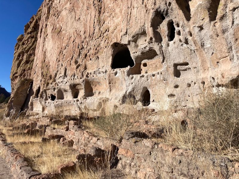
Climbing wooden ladders into 800-year-old cliff dwellings carved directly into volcanic rock is not something most people expect to do on a Tuesday afternoon. Bandelier National Monument makes it completely possible.
The ancestral Pueblo people built their homes here in Frijoles Canyon around 1150 CE.
The main loop trail is only about 1.5 miles long but packs in cave rooms, petroglyphs, and a reconstructed circular village. You can actually climb into some of the alcove dwellings using the ladders, which is a hands-on history experience that kids and adults both love.
The canyon walls are covered in soft volcanic tuff that the Puebloans carved with stone tools.
Bandelier sits about 45 minutes from Santa Fe, making it an easy day trip. Summers require a shuttle from the nearby town of White Rock due to parking limits at the monument.
Visitation is surprisingly manageable compared to Mesa Verde. The combination of stunning geology and human history makes this one of New Mexico’s most underrated destinations.
Katahdin Woods and Waters National Monument, Maine
Maine’s newest national monument was designated in 2016 and has been quietly sitting there ever since, waiting for people to notice. Katahdin Woods and Waters covers 87,563 acres of remote forest, rivers, and mountains in the north woods of Maine.
The crowds have not caught on yet, and long may that last.
Mount Katahdin, the northern terminus of the Appalachian Trail, looms over the western edge of the monument. The area offers world-class paddling on the East Branch of the Penobscot River.
Moose sightings are practically guaranteed if you spend any time near the water at dawn or dusk.
Getting here requires a real commitment. The nearest services are in Millinocket, a small town about 20 miles away.
Roads inside the monument are mostly gravel and can be rough. That remoteness is the entire appeal.
This is Maine as it looked before highways and cell towers, and it is absolutely breathtaking.
Apostle Islands National Lakeshore, Wisconsin
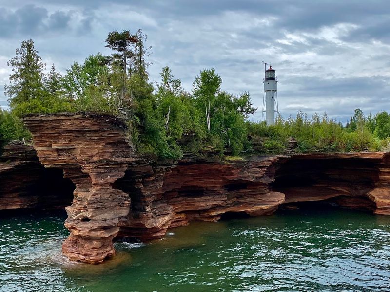
Lake Superior is not the ocean, but the Apostle Islands will make you question that. This collection of 21 islands off the tip of Wisconsin’s Bayfield Peninsula features sea caves, shipwrecks, historic lighthouses, and water so clear it barely looks real.
The sea caves along the mainland shoreline are the big draw. In winter, when the lake freezes, people walk across the ice to explore the caves draped in frozen waterfalls and ice formations.
In summer, kayakers paddle through the arched openings with the sandstone walls glowing orange above them. Both experiences are genuinely unforgettable.
The town of Bayfield is one of the most charming small towns in the Midwest, with excellent apple orchards, seafood, and a ferry service to Madeline Island. Summer weekends can get busy near the caves, but the outer islands stay quiet.
Camping on the islands requires a permit but rewards you with total solitude on Lake Superior’s shores.
El Morro National Monument, New Mexico
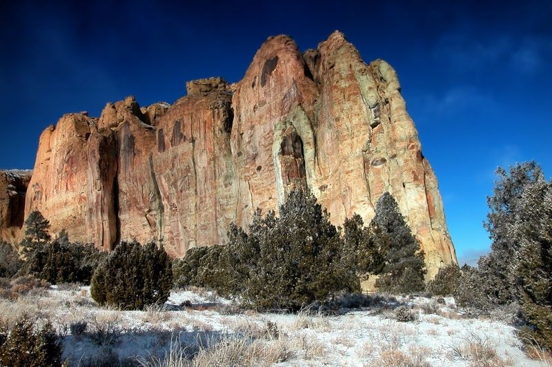
El Morro is essentially a 200-foot sandstone bluff that served as the world’s oldest travel journal. Spanish conquistadors, Native peoples, and American pioneers all stopped here over centuries and carved their names, dates, and messages into the soft rock.
The earliest known inscription dates to 1605.
The natural pool at the base of the bluff is the reason everyone stopped here in the first place. In a dry stretch of New Mexico, this reliable water source was a lifesaver for travelers.
Reading the inscriptions is like scrolling through history in real time. Juan de Onate signed the rock.
U.S. Army surveyors signed it too.
The 2-mile loop trail climbs to the top of the bluff, where Ancestral Puebloan ruins sit overlooking the valley. Visitation here is wonderfully low.
The monument sits along Highway 53 between Grants and Zuni, New Mexico. Plan at least two hours to appreciate the full scope of what you’re reading on those walls.
Florissant Fossil Beds National Monument, Colorado
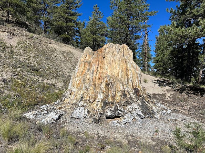
Thirty-four million years ago, a volcanic eruption buried a thriving lake ecosystem in Colorado, preserving everything in extraordinary detail. Today, Florissant Fossil Beds National Monument protects what scientists call one of the richest fossil deposits on the planet.
And almost nobody visits.
The star attractions are the massive petrified redwood stumps, some over 14 feet in diameter, that stand scattered across open meadows. Over 1,700 species of insects, plants, and fish have been identified from fossils found here.
The detail preserved in the shale is astonishing, down to individual butterfly wing patterns from millions of years ago.
The monument sits just west of the town of Florissant, about an hour from Colorado Springs. The visitor center has impressive fossil displays and friendly rangers who clearly love talking about the site.
Trails are easy and well-maintained. Entrance fees are modest.
This is one of those places where you leave knowing significantly more than when you arrived, which is the best kind of trip.
Cumberland Gap National Historical Park, Kentucky, Tennessee, and Virginia
Before the interstate highway system, before railroads, before most of America even existed as a country, there was Cumberland Gap. This natural break in the Appalachian Mountains was the doorway through which hundreds of thousands of settlers poured west.
Daniel Boone helped blaze the trail here in 1775.
The park spans three states simultaneously, which is a fun geographic quirk worth experiencing. The Pinnacle Overlook at 2,440 feet offers a sweeping view of the gap that makes history feel very immediate.
On a clear day, you can see across Kentucky, Tennessee, and Virginia all at once.
The Wilderness Road, which Boone’s party carved, still exists as a hiking trail through the park. The Gap Cave tour is a popular add-on, featuring a limestone cavern with impressive formations.
The town of Middlesboro, Kentucky, sits just outside the park and was actually built inside a meteor impact crater. That detail alone is worth the detour.
Antietam National Battlefield, Maryland
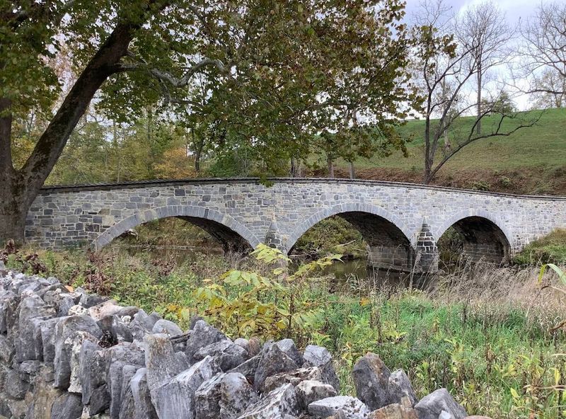
September 17, 1862, was the bloodiest single day in American military history. Nearly 23,000 soldiers were killed, wounded, or missing at Antietam in a battle that lasted just 12 hours.
Standing on those fields today, the quiet is almost overwhelming.
The battlefield is remarkably well-preserved. Cornfields, sunken roads, and creek crossings where the fighting happened still look much as they did in 1862.
The famous Burnside Bridge, a graceful stone arch over Antietam Creek, is one of the most photographed Civil War sites in the country. The visitor center film is excellent and genuinely moving.
Antietam sits near Sharpsburg, Maryland, about 70 miles from Washington D.C. It draws far fewer visitors than Gettysburg despite being equally significant.
Fall is the best time to visit, when the surrounding farmland turns golden and the battlefield takes on a haunting beauty. A self-guided driving tour covers all the major sites in about two hours.
Organ Pipe Cactus National Monument, Arizona
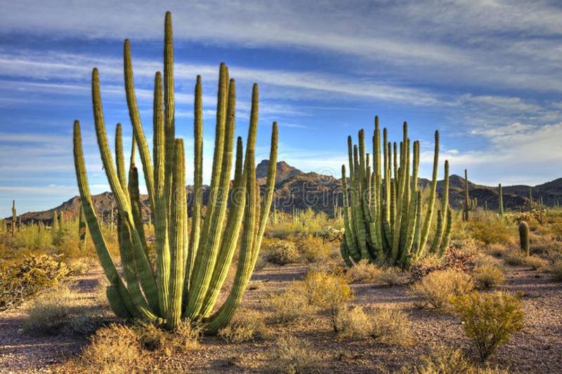
The organ pipe cactus grows in only one place in the United States, and that place is a remote stretch of southern Arizona along the Mexican border. The cactus gets its name from its clusters of tall arms that do, with some squinting, resemble the pipes of a church organ.
The monument covers 330,000 acres of Sonoran Desert and is one of the most biologically diverse desert areas in North America. Over 30 species of cacti grow here alongside roadrunners, Gila woodpeckers, and the occasional Gila monster.
Spring wildflower blooms can be spectacular when winter rains cooperate.
The Ajo Mountain Drive, a 21-mile unpaved loop, is the best way to explore the monument by car. Camping at the Twin Peaks campground puts you right in the heart of the cactus forest.
The nearest town, Ajo, has basic supplies and a surprisingly charming town plaza. Remote, wild, and genuinely unlike anywhere else in the country.


