You have probably seen the satellite photos, the strange lights, and the impossibly engineered ruins. Yet even with supercomputers, deep sea subs, and space-age sensors, some places on Earth still shrug at our best explanations.
These sites challenge what you think you know about geology, climate, ancient engineering, and life itself. Lean in, because the weird gets fascinating fast – and a few might change how you read the planet.
1. Stonehenge, England
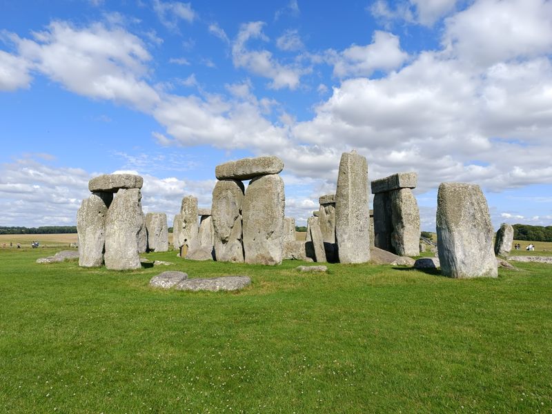
Stand at dawn and the stones feel alive. Transporting multi-ton bluestones over long distances without wheels still sparks debate.
Was it sledges on greased trackways, river rafting, or something we have not tested yet?
Its purpose is equally layered: an astronomical calendar, ritual space, or social glue binding far-flung communities. Isotope studies show people and animals traveled here seasonally.
That implies complex networks and planning.
Despite decades of excavation, we keep finding surrounding pits and avenues that expand the story. Each discovery solves one puzzle piece and scrambles three more, keeping Stonehenge tantalizingly unresolved.
2. The Great Blue Hole, Belize
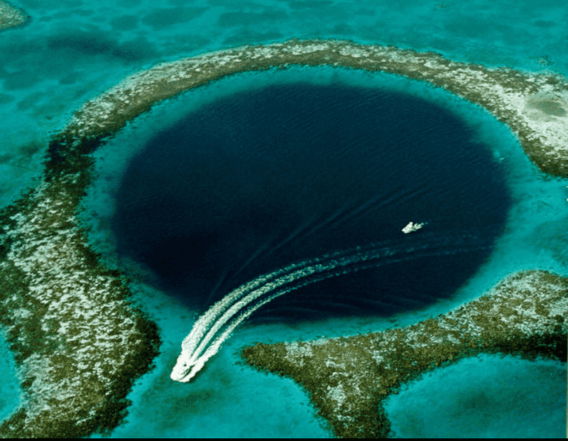
From above, it looks like an eye staring back. Inside, the Great Blue Hole holds stacked layers where oxygen plunges and chemistry changes fast.
Stalactites suggest it formed in dry times, then drowned as seas rose.
Divers find zebra-like microbial mats and minimal life in deeper zones. How did the stratified layers evolve so precisely?
Sediment cores tell climate stories, but timing and flow pathways remain uncertain.
Hydrodynamics here are quirky, swinging with storms and tides. The site doubles as a climate archive and a mystery box, begging for more sampling and long-term sensors.
3. Göbekli Tepe, Turkey
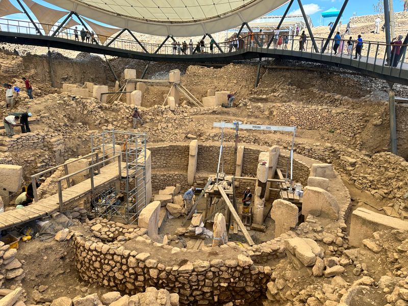
Imagine a temple older than farming. At Göbekli Tepe, hunter-gatherers carved towering T-pillars with foxes, snakes, and birds, assembling labor and symbolism at shocking scale.
It challenges the tidy idea that agriculture came first.
How did mobile groups coordinate feasts, tools, and quarrying? The site’s intentional burial complicates timelines and purpose.
Ritual, social bonding, and power displays all fit, yet none fully explain the effort.
As new enclosures emerge, we see regional connections, not a one-off marvel. Still, the leap in organization here remains a gap in our models of cultural evolution.
4. The Bermuda Triangle, Atlantic Ocean

You have heard the myths, but the reality is messier. Heavy traffic, sudden squalls, and human error explain much, yet navigational oddities persist.
Some magnetometer readings and microburst events leave questions open.
Insurers do not price it differently, which calms hype. Still, pilots report compass swings and optical illusions over sharp temperature gradients.
Methane blowouts have been suggested, though evidence is thin.
Think of it as a laboratory for risk: crowded lanes, tricky weather, and perception under stress. Untangling signal from noise keeps the Bermuda Triangle scientifically relevant, not just legendary.
5. Lake Hillier, Australia
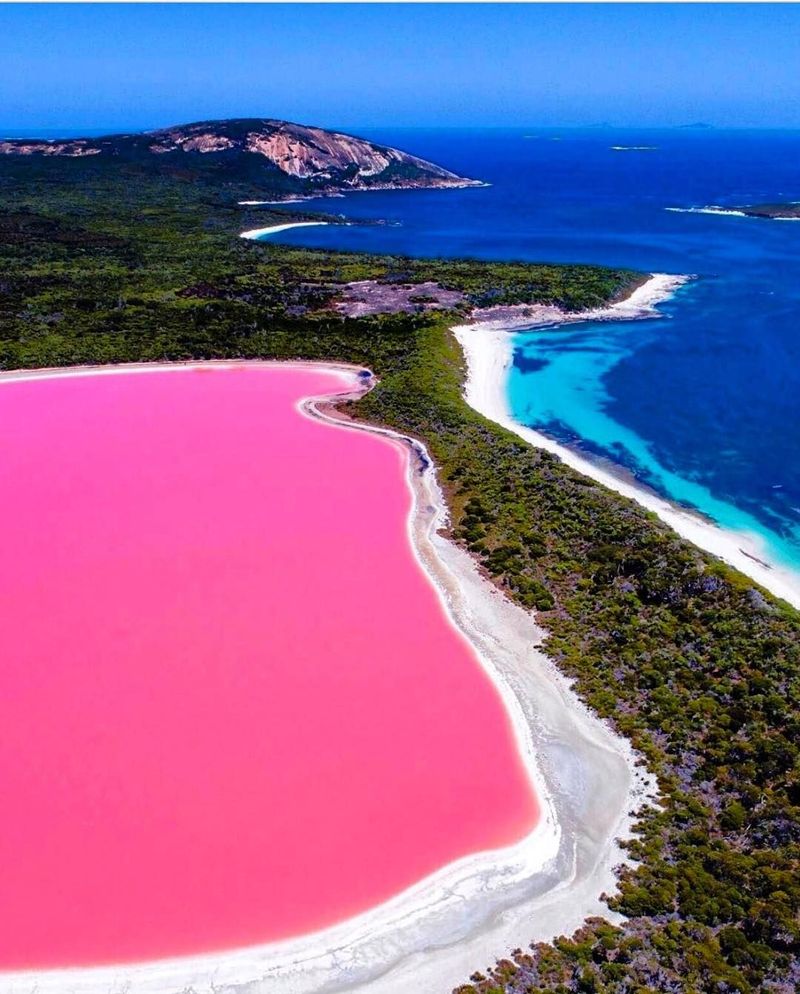
Lake Hillier looks Photoshopped until you are standing above it. That persistent pink hue resists seasons and dilution.
Microbes like Dunaliella and haloarchaea, plus salt chemistry, orchestrate the color, but the exact stability recipe is still elusive.
Unlike some pink lakes, Hillier stays pink even in jars, hinting at robust pigments and brines. Salinity, sunlight, and community shifts likely tune intensity.
Why does this ecosystem maintain balance so stubbornly?
Sampling improves our guesses, yet the microbes’ interactions and viral dynamics need deeper study. The result is a candy-colored window into extremophile resilience and chemistry.
6. The Nazca Lines, Peru
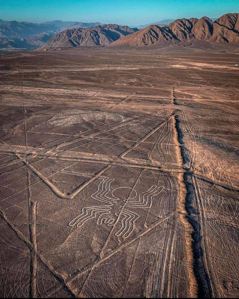
From the ground, you see lines. From the air, giant hummingbirds and trapezoids snap into focus.
How ancient designers achieved such precision without aerial views still inspires experiments with sightlines and simple tools.
Purposes range from ritual pathways to water markers. Ceramic fragments and posts suggest staged performances across the desert floor.
Was visibility to sky gods the point?
Wind and rare rains threaten erosion, yet the plateau’s dryness preserves art that doubles as a cosmic billboard. We can reproduce techniques, but the cultural logic behind those vast canvases remains intriguingly unresolved.
7. The Taos Hum, New Mexico, USA
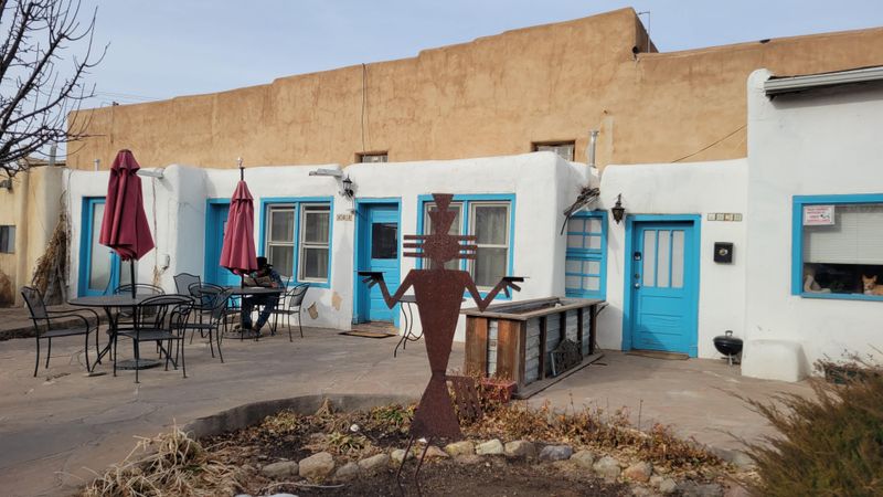
In Taos, some residents hear a low, persistent hum that measuring gear often fails to catch. Not everyone perceives it, which complicates testing and makes you question perception itself.
Is it external sound or internal processing?
Studies point to a mix of environmental noise, industrial sources, and auditory sensitivity. Yet no single source fits all reports.
The variability across neighborhoods only deepens the mystery.
Whether physics, physiology, or both, the hum highlights how human hearing filters the world. Until a repeatable source is pinned down, Taos remains an acoustic riddle with human stakes.
8. Devil’s Kettle Waterfall, Minnesota, USA
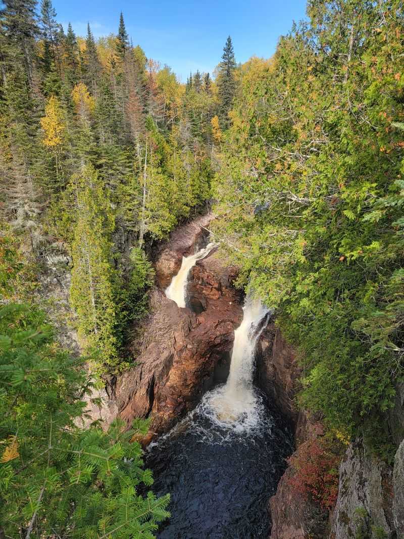
Here the Brule River splits: one half tumbles visibly, the other vanishes into a rock cauldron called the Devil’s Kettle. For decades, tossed objects failed to reappear.
That fueled spooky theories.
Recent dye and temperature tests suggest the disappearing water rejoins downstream, bypassing surface visibility through fractures. Yet the unusual plumbing and pothole formation still provoke questions about erosive energies.
It is a reminder that rivers hide shortcuts within bedrock. Even when a partial answer emerges, the geological choreography behind it keeps geomorphologists returning with new instruments and hypotheses.
9. Sailing Stones of Racetrack Playa, California, USA
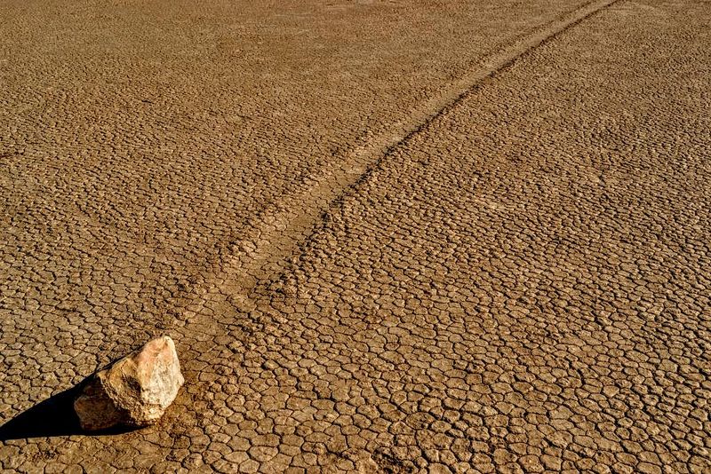
Imagine heavy rocks gliding across a dry lake, leaving long tracks like signatures. The mechanism now points to thin ice panels, water films, and wind working briefly in sync.
Getting those conditions to align is rare, which explains the long waits between movements.
GPS-tagged stones finally captured motion, but micro-details remain. How do crystal sizes, mud texture, and gust timing collaborate?
Each winter resets variables.
Racetrack Playa is a natural physics lab. It teaches that simple forces can perform elegant tricks when timing is perfect, and it still surprises researchers who camp for years to catch minutes.
10. The Eye of the Sahara (Richat Structure), Mauritania
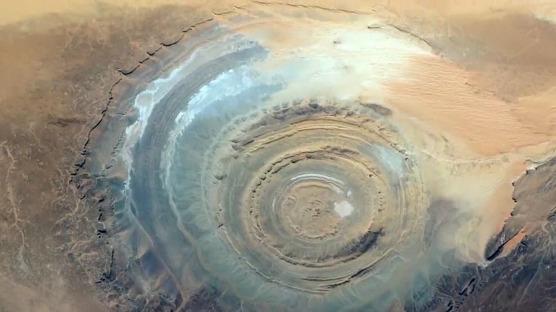
From space, the Eye of the Sahara looks like a bullseye stamped into North Africa. Once suspected as an impact crater, it is now framed as a domed uplift eroded into rings.
But the sequence of uplift, volcanism, and erosion is still debated.
Minerals and ring asymmetry hint at complex plumbing below. Did fluids alter rocks unevenly?
Dating layers precisely is hard in such a harsh environment.
The Richat Structure shows how geology can mimic intent. It is a reminder that Earth sculpts patterns that feel designed, yet their blueprints remain partially hidden in deep time.
11. Mount Roraima, Venezuela Brazil Guyana
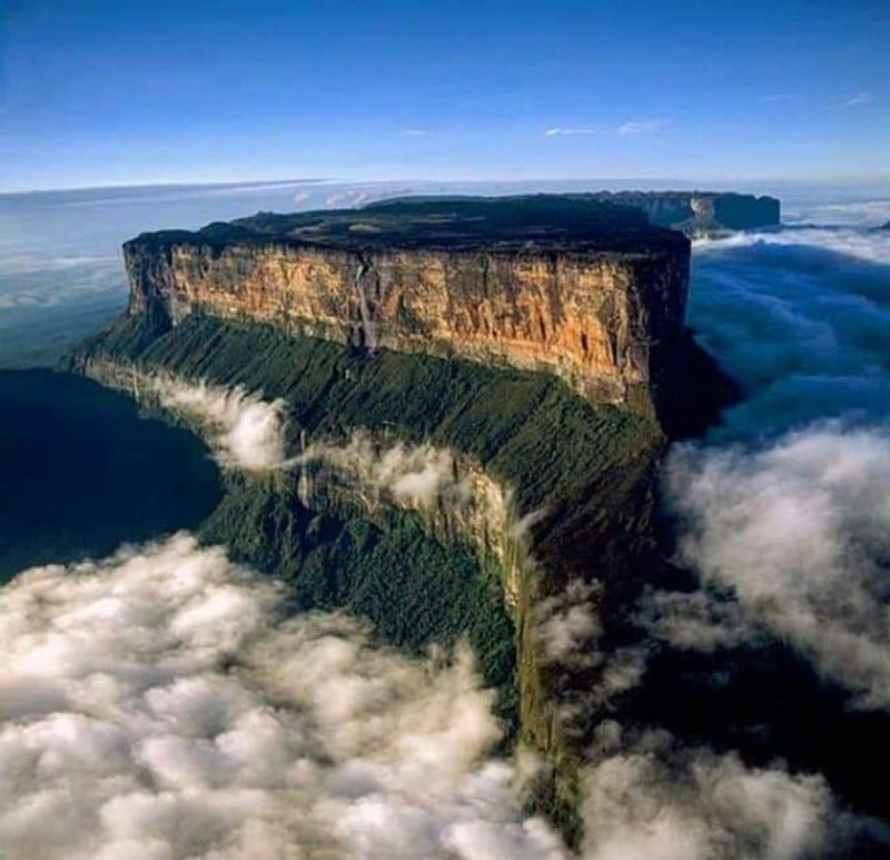
Roraima is a tabletop in the clouds, its edges dropping like walls. The plateau isolates species on stone islands, incubating odd plants and insects.
You are basically looking at a living lab of evolutionary divergence.
How long each summit has been isolated and how often genes cross via birds or wind remains unclear. The sandstone filters water into surreal pools that tweak chemistry and microhabitats.
Conservation meets mystery here. As surveys map new species, biogeographers wrestle with timing and pathways, trying to reconstruct traffic across the sky bridges that may never have existed.
12. Blood Falls, Antarctica
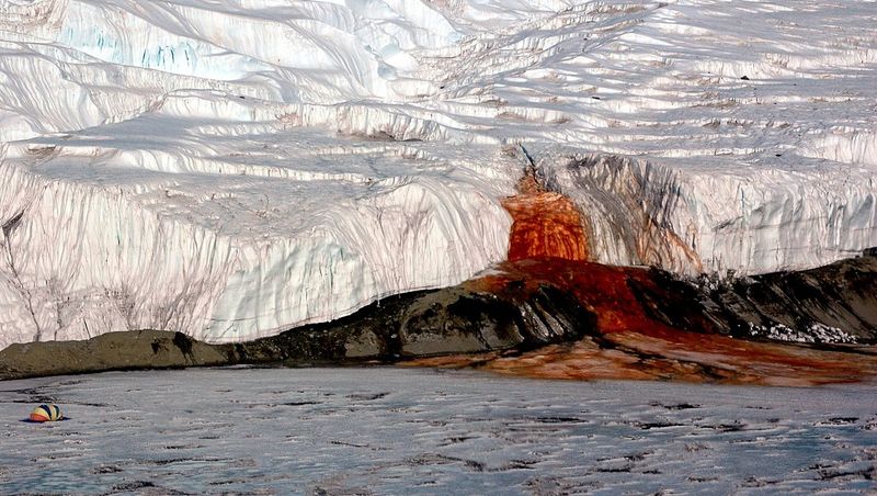
At Blood Falls, iron brine bleeds from a glacier’s wound. The red comes from oxidation, but the real story is microbial life thriving without sunlight, in salty, oxygen-poor water.
It is an earthly analog for icy moons.
How that sealed ecosystem persists, trades energy, and avoids freezing solid remains partly unknown. Geophysical scans suggest complex subglacial plumbing and brine pockets.
As Antarctica warms unevenly, access windows widen. Each sterile drill bit must avoid contamination while chasing life’s limits.
What we learn here informs future missions to Europa and Enceladus.
13. The Yonaguni Monument, Japan
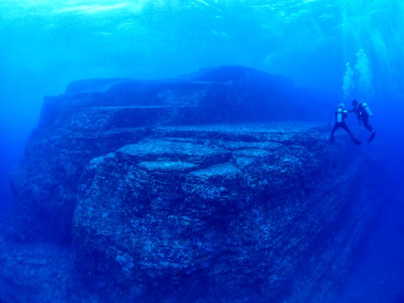
Beneath Yonaguni’s waves, stone steps and terraces look eerily architectural. Are they man made, or are currents and fractures carving deceiving geometry?
Divers disagree at the very edges of interpretation.
Tool marks are contested, and stratigraphy complicates claims. Earthquakes and wave action can prune rock into uncanny forms.
Yet some right angles tempt the imagination toward lost cities.
Until dating and contextual artifacts line up, the monument sits in limbo. It is a case study in geological pareidolia and the human urge to find intention in nature’s drafts.
14. The Hessdalen Lights, Norway
In Norway’s Hessdalen Valley, lights hover, dart, and fade, recorded by cameras and radar. That makes this more than campfire lore.
Theories include plasma from piezoelectric rocks, ionized dust, and atmospheric chemistry.
None explains every color, motion, or duration. The phenomena spike seasonally, suggesting weather or ground stress coupling.
But a single switch has not been found.
Citizen science rigs watch the valley, and each dataset adds constraint. You get a reminder that the sky can host slow puzzles, not just fast meteors, and that patience is part of physics.
15. Amazon’s Dark Earth (Terra Preta)
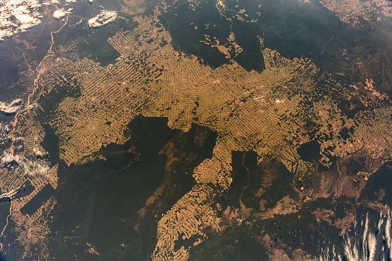
Across the Amazon, patches of black, fertile earth outgrow adjacent soils by a mile. Terra preta holds nutrients and carbon for centuries.
It looks engineered by ancient communities using charcoal, bone, and waste.
Exactly which microbes and char structures lock this fertility remains unsettled. Recreating it reliably at scale could reshape sustainable agriculture and carbon storage.
Today, soils cover roughly two percent of the region yet influence settlement patterns. If we decode the recipe, farmers worldwide could boost yields while storing carbon long term, a rare win for food and climate.
16. Lake Vostok, Antarctica
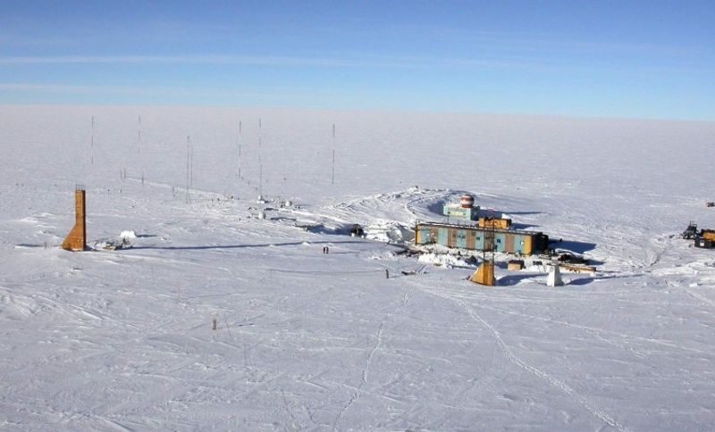
Buried beneath nearly four kilometers of ice lies Lake Vostok, sealed off for perhaps millions of years. It is a time capsule for unknown microbes and novel chemistry.
Sampling without contamination is a moon-landing level challenge.
Pressure, darkness, and isolation turn the lake into a natural lab for extremophiles. Radar and seismic data sketch shapes, but currents and nutrient cycles are guesses.
Drilling advances slowly under strict protocols. What we learn here will guide life-detection on icy worlds and refine ice-sheet models that affect sea level projections for coasts you know.
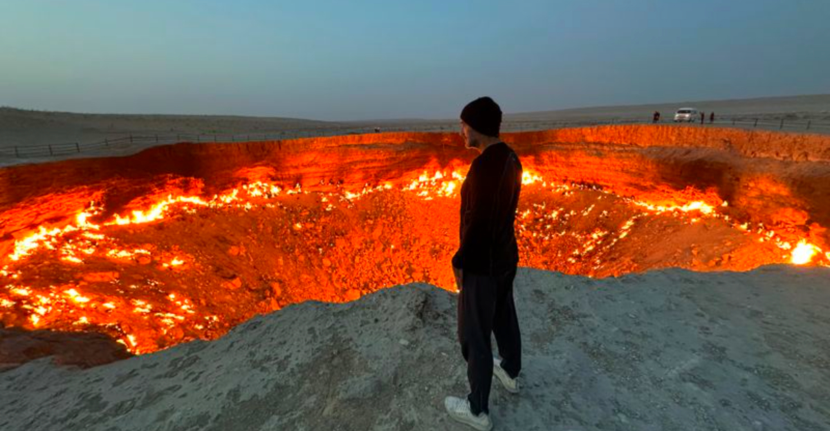
17. The Door to Hell, Turkmenistan
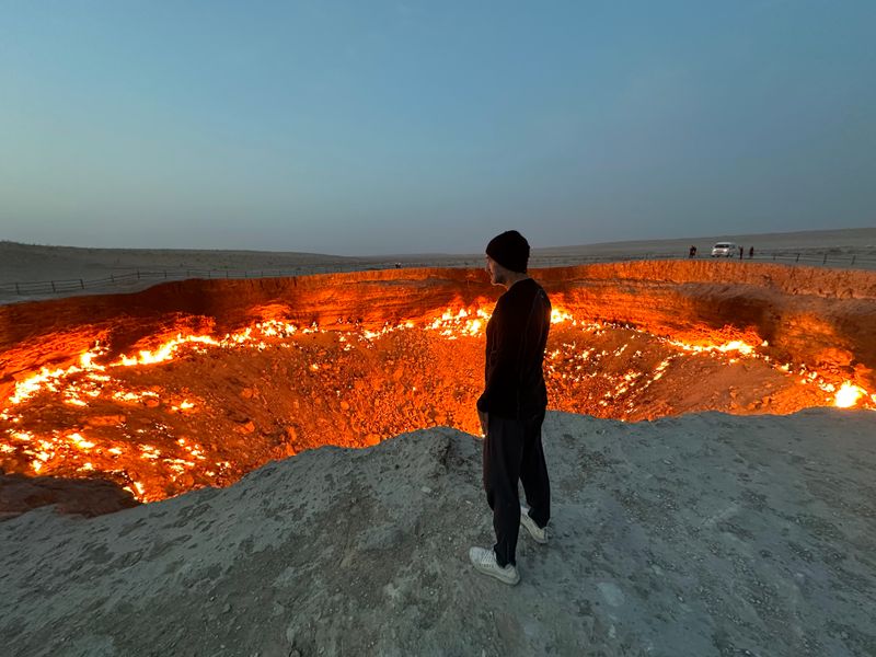
In Turkmenistan’s Karakum Desert, a roaring crater burns day and night. Geologists reportedly ignited leaking gas decades ago to prevent a bigger hazard.
It was expected to burn out quickly, yet it persists.
The subsurface plumbing that feeds it is poorly mapped. How much gas remains and how it migrates challenge straightforward estimates.
Visitors describe a furnace breathing in the sand sea.
Officials have debated capping it, but uncertainty stalls action. The crater is an accidental laboratory for combustion, seep dynamics, and our uneasy relationship with fossil fuels beneath our feet.
18. The Boiling River of Shanay Timpishka, Peru
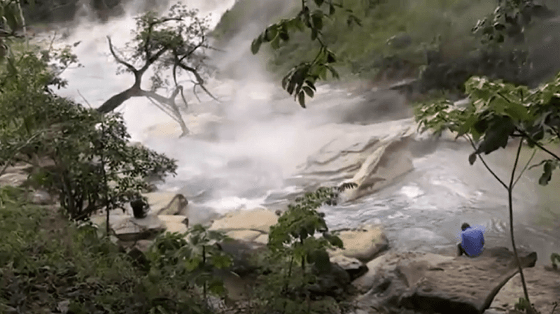
Deep in Peru, a river runs hot enough to scald instantly, far from major volcanism. Groundwater likely taps deep geothermal pathways, but the plumbing is not mapped.
You feel the heat on your skin well before the bank.
Thermal gradients change with rains, hinting at complex recharge. Wildlife adaptations and microbial communities are just beginning to be cataloged.
The river blends traditional knowledge with geoscience detective work. Until we trace every fracture and aquifer connection, it remains a steamy reminder that heat can travel quietly under thick rainforest.


