A volcano that slept for thousands of years just jolted the world awake. Hayli Gubbi in Ethiopia erupted with a plume so tall it touched airline routes and sent planners scrambling. If you thought remote volcanoes stay local, this one proves otherwise. Keep reading to see what happened, how it spread, and what it means for you and global travel.
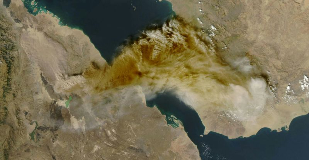
On 23 November 2025, Hayli Gubbi roared to life after an estimated 12,000 years of quiet, startling residents across Ethiopia’s Afar Region. The remote shield volcano, sitting near 493 m in elevation in the Erta Ale range, unleashed a powerful eruption that sent ash soaring to roughly 13 to 14 km. You could almost feel the shock through eyewitness accounts describing a sudden bomb like thud, a shock wave, and a sky that filled with smoke and grit.
What occurred geologically ties back to the East African Rift, where the African Plate is pulling apart and magma can rise along fractures. In the months before the blast, satellites had flagged thermal anomalies and hints of fissure opening between Erta Ale and Hayli Gubbi, subtle signs of magma on the move. Those clues foreshadowed an explosive episode that surprised many because this volcano had no recorded Holocene eruptions in the Global Volcanism Program database.
The eruption’s intensity stood out, not only due to its height but its reach across regional air corridors. Ash rose into upper tropospheric levels and began drifting downwind, prompting rapid attention from the Toulouse VAAC and other centers. If you track aviation maps, you saw advisories pop up as the plume spread beyond the Afar lowlands and into wider skies.
On the ground, Afdera and nearby villages felt the brunt of immediate ash fall. Roofs, roads, and grazing areas turned gray, and fine ash settled into water containers and animal troughs. You could taste the dryness in the air, and simple tasks like tending herds or fetching water became gritty and difficult.
Scientists are parsing the eruption style to understand why a shield volcano delivered such a punch after so long. Rapid degassing, interaction with groundwater, or opening along rift fissures may have amplified explosivity. The lack of dense monitoring networks here means much of the early story comes from satellites, pilot reports, and the people who heard and felt that first jolt.
Air travel disruptions followed fast as the ash crossed the Red Sea and pushed toward the Arabian Peninsula and beyond. Indian carriers preemptively canceled flights when models showed ash encroaching on Indian airspace, a reminder that risk does not respect borders. If you were traveling that week, the ripple effects likely touched your itinerary, even if you were nowhere near Afar.
For volcanology, Hayli Gubbi’s awakening is a wake up call about so called sleeping giants in rift settings. Long quiet does not equal low risk, and sparse records can hide complex magmatic histories. You do not need a famous name for a volcano to command global attention when the winds and the jet stream line up.
In the near term, the immediate impacts revolve around ash cleanup, water safety, and herd health. Longer term, researchers will test plume samples, refine ash dispersion models, and look for deformation signals that might hint at what comes next. If this episode transitions to effusive activity or additional vents, the hazard map could change quickly for people on the ground and planes overhead.

From the start, the ash plume rose high enough to intersect busy flight levels and turn routine routes into risk calculations. You could see airlines pivot in real time, with carriers like Air India and Akasa Air canceling or rerouting as advisories flagged potential ash ingestion hazards. As the cloud drifted toward Yemen and Oman and then farther to India and northern Pakistan, regulators issued guidance to keep jets clear.
For travelers, that meant delays, cancellations, and longer flight paths that skirted contaminated air. Dispatchers and meteorologists leaned on VAAC bulletins, satellite retrievals of ash and sulfur dioxide, and trajectory models to redraw plans. If you checked your app and wondered why a clear sky day still grounded flights, ash and engine safety were the reason.
Closer to the volcano, communities faced an entirely different fallout. Afdera’s grazing lands and rooftops collected a thick dusting that clogged gutters and coated forage. You might think ash is fluffy, but it is glassy and abrasive, and livestock can suffer if it contaminates water or pastures for long.
Local guides and tourists in the Danakil Depression felt the disruption as visibility dropped and services paused. Roads became slippery under fine ash, and respiratory irritation turned simple hikes into risky ventures. Even without fatalities, the economic hit showed up quickly in lost tour days and emergency supply runs.
Environmental signals emerged alongside the human story. Satellite sensors tracked sulfur dioxide columns and aerosol layers that can dim sunlight and degrade air quality downwind. You could smell the sharpness in the air if you were near the plume edge, and sensitive groups needed masks or indoor shelter until concentrations eased.
The remote setting complicated rapid field measurements, but space based data filled gaps with plume heights, mass loading, and drift paths. Regional forecasters blended those feeds into advisories that rippled across aviation, health, and agriculture channels. If you manage risk, this was a stress test of cross border coordination under fast moving uncertainty.
Beyond immediate logistics, the eruption reframed assumptions about rift volcanoes that rarely make headlines. Long quiescence lulled planners into thinking these systems were low priority for monitoring, yet one event sent ash across continents. You can see why funding discussions for ground sensors and community alerts gained urgency overnight.
In sum, Hayli Gubbi became a case study in how a remote blast touches planes, pastures, and people. The lesson is simple but sharp: track the quiet corners of the map because they can roar when conditions align. If you fly these corridors or live downwind, preparedness now pays off when the next plume rises.
Now that the plume has thinned, attention turns to what the data can tell us and how to prepare for any follow up. Scientists will parse thermal anomalies, deformation from InSAR, and plume composition to refine models of rift volcanism. You do not need a sprawling network to learn a lot, but adding seismometers, GPS, and gas sensors would sharpen forecasts the next time pressure builds.
The big questions hang in the air. How long did magma accumulate, and what tipped it into an explosive phase after millennia of calm. If the system shifts toward effusive lava or opens new fissures along the rift, hazard footprints will change for herders, travelers, and any teams working nearby.
Preparedness starts with basics you can act on. Clear ash from roofs and gutters safely, protect water sources, and use masks when concentrations spike. Local authorities and NGOs can map alternative grazing zones, set up health screenings, and coordinate transport routes that avoid low visibility stretches.
For aviation, the lesson is to treat remote volcanoes as non trivial actors in global routing. Expanding satellite driven alerts, rehearsing reroute playbooks, and running joint exercises with VAACs and airlines can cut response times. You might not see a plume, but engines do not forgive volcanic glass at cruising altitude.
On the science side, drones and rapid sampling can bridge the monitoring gaps. Ash grain size, chemistry, and sulfur dioxide flux will reveal how deep the pulse came from and whether gas rich pockets remain. You can expect teams to compare this event with Erta Ale activity to understand shared plumbing along the rift.
Community resilience deserves equal focus. Micro grants for livestock feed, mobile clinics for respiratory care, and school cleanups can help life return to normal faster. When people trust alerts and see quick support, they are more likely to heed future warnings without hesitation.
Internationally, agencies should revisit risk frameworks to include quiet rift zones that intersect busy air corridors. Routing models can layer volcanic probability with seasonal winds to flag days when a small blast would have outsized impact. If you plan logistics, this is a chance to build redundancy before the next surprise.
What comes next at Hayli Gubbi remains uncertain, but vigilance is your best tool. The explosive phase reportedly subsided the same day, yet magma systems can reawaken in pulses. If monitoring lights up again, clear communication and swift action will turn a startling event into a manageable one.


