Big quakes along the Alaska-Canada border are not random surprises. They are the result of deep forces pushing, grinding, and flexing the crust beneath some of the wildest terrain on the continent. If you have wondered whether this frontier is truly heating up seismically, the latest data and a striking 2025 event paint a vivid picture. Let’s break down what happened and why you should care, even if you are far from the epicenter.
On December 6, 2025, a magnitude 7.0 earthquake struck along the Alaska-Canada border, grabbing immediate attention. You probably saw the headlines, but the magnitude alone does not tell the full story. A 7.0 delivers strong shaking that can be widely felt and can generate numerous aftershocks.
Magnitude describes released energy, not damage, so context matters. In a remote region with resilient ground conditions and sparse infrastructure, impacts can be limited. Still, a 7.0 is powerful enough to test emergency systems, reveal weak structures, and remind travelers and residents to keep go-bags ready.
Think of it as a wake-up call. A single number condenses complex rupture physics and radiated waves. It signals potential cascading hazards and ongoing aftershock sequences.
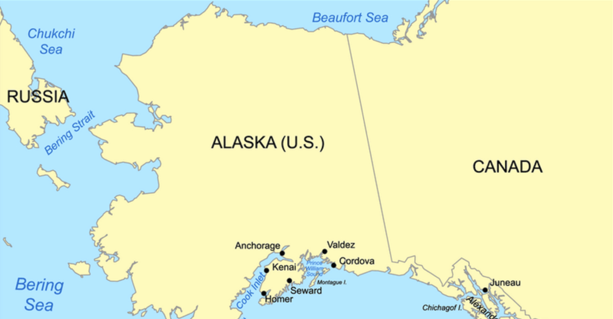
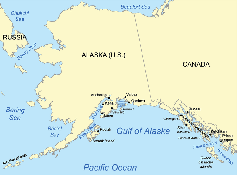
The epicenter struck a remote sector about 230 miles northwest of Juneau, Alaska, and roughly 155 miles west of Whitehorse, Yukon. That places it in rugged terrain where glaciers, fjords, and steep valleys funnel seismic waves in complex ways. You would not find dense cities here, but the ground still carries energy far.
Remote does not mean irrelevant. Long-period waves can travel efficiently through cold crust, delivering gentle but persistent motion to distant communities. Mountain roads, pipelines, and small airstrips may feel it.
For travelers and logistics planners, knowing these distances helps frame potential delays. It also explains why reports trickled in across a wide area. In seismic terms, location is destiny.
The earthquake’s hypocenter was shallow, estimated between 6 and 10 kilometers. Shallow ruptures often produce stronger shaking near the surface since waves have less rock to travel through before reaching you. That is why nearby regions reported crisp, jolting motion rather than a slow roll.
Depth shapes damage potential. Even in remote zones, shallow quakes can jostle infrastructure like bridges, embankments, and utility corridors. They also produce higher-frequency waves that rattle shelves and windows.
Because wave attenuation is limited, small communities felt the snap quickly. Emergency managers watch shallow events closely for landslide triggers. The depth range here aligns with active crustal faults and the upper plate above the subduction interface.
More than 30 aftershocks rattled the region after the mainshock, several reaching moderate intensity. If you felt repeated tugs or quick thumps, that was the crust adjusting along the new stress landscape. Aftershocks commonly decay in frequency but can persist for weeks or months.
Expect the largest aftershocks to occur early, though surprises happen. Aftershock zones map the rupture extent and nearby stressed faults. Tracking them helps scientists refine hazard estimates and advise communities about ongoing risk.
For you, that means staying alert even after the headlines fade. Shelve heavy items securely, check emergency kits, and follow local guidance. Aftershocks are not afterthoughts. They are part of the main event’s evolving story.
Nearest populated areas, including Yakutat, Alaska with roughly 662 residents, reported minor shaking and no major structural damage. Small Yukon communities felt it too, mostly as brief rattles and nervous moments. You might have seen swaying lamps, shifting cabinet contents, or a few cracked plaster lines.
Why was damage limited? Distance from the epicenter, building types, and local ground conditions all matter. Many structures are low-rise and flexible, and population density is low.
Still, even minor shaking can disrupt. People call relatives, check supplies, and inspect chimneys, fuel tanks, or water lines. It is a reminder to keep essentials handy and maintain communication plans, especially where winter weather complicates travel.
This border sits near one of Earth’s great engine rooms. The Pacific Plate dives beneath the North American Plate, generating immense stresses that periodically release as earthquakes. If you picture conveyor belts colliding and grinding, you have the basic idea.
Subduction builds mountains, feeds volcanoes, and loads faults with strain. Not every quake occurs on the plate interface. Many rupture within the overriding plate where stress transfers and bends the crust.
For you, this means a persistent background drumbeat of seismicity. It is not random. It is physics playing out in slow motion, then suddenly fast. The 7.0 fits the regional pattern of accumulated stress seeking the quickest release path.
The border zone lives in the shadow of giants. The 1964 Alaska earthquake reached magnitude 9.2, among the largest ever recorded worldwide. While its epicenter was farther south, it demonstrates the region’s capacity for extraordinary seismic release.
Historical catalogs also show numerous large crustal events scattered inland. These quakes reveal how stress propagates beyond the trench and along complex fault networks. When you read about today’s events, remember the long memory of the crust.
Past shaking informs modern codes and drills. Communities refine response plans because history teaches hard lessons. If you live or travel near the border, the record is clear. Big quakes are rare but not unexpected.
The region hosts a tangled mix of fault styles. Strike-slip systems like the Queen Charlotte-Fairweather Fault slice laterally, while subduction-related faults compress and uplift. This diversity means shaking can arrive as sharp side-shears or vertical jolts.
Multiple fault types increase hazard complexity. When you stand on this landscape, you are atop braids of weakness that respond differently to stress. A rupture on one system can nudge stress elsewhere, priming another fault for movement.
For planners, that diversity demands flexible design assumptions. Bridges, pipelines, and fiber routes need to withstand varied motions. And for residents, it underscores why preparedness cannot hinge on a single quake scenario.
Deformation does not stop at the coast. It pushes far inland, where crustal faults crisscross valleys and plateaus. Even remote areas feel the tug-of-war between plate motions and rigid blocks.
If you travel across the interior, you might pass over hidden structures that have not ruptured in recent memory. That quiet is deceptive. Stress can build silently for decades, then release in seconds.
For you and small communities, this means risk without daily reminders. Road cuts, embankments, and fuel depots should be inspected after notable shaking. Interior faults spread the footprint of potential damage, widening the zone that must prepare.
Faults do not pause at customs. The Denali Fault and other transboundary structures run from Alaska into Yukon, creating a shared corridor of seismic vulnerability. If one segment moves, neighboring stretches may see stress changes that matter.
Cross-border coordination is essential. Data sharing, drills, and communication protocols make responses faster when seconds count. You want alerts to cross boundaries as quickly as waves do.
For travelers and transport companies, routes weave back and forth across the line. Consistent standards for inspections and closures reduce confusion. Earthquakes ignore political maps, so our preparedness should too.
Reports arrived from hundreds of kilometers away across southern Alaska and Yukon. Long-period waves traveled efficiently through the cold, stiff crust, rocking high-rise sensors and rattling dishes in distant kitchens. If you felt a gentle sway far from the epicenter, you were not imagining it.
Wide felt areas complicate response. Dispatchers field calls from many communities simultaneously. Utilities may perform network-wide checks even when no damage is obvious.
For you, this breadth means alerts can pop up even if you are hours away by road. It is a cue to verify supplies, check gas shutoff tools, and review family plans. Broad reach magnifies the need for consistent messaging.
No tsunami was generated, but other hazards mattered. Steep slopes can shed rock and snow after strong shaking, and glaciers may destabilize where crevasses and melt channels weaken support. If you hike or drive mountain passes, consider recent shaking before committing.
Landslides can dam creeks, muddy rivers, or block roads. Small airstrips and pipeline corridors near valley walls deserve inspections after shocks. Winter conditions may hide cracks until thaw.
Your safest move is to check official advisories and local guides for trail and road updates. Carry basics like headlamps, first aid, and extra layers. Secondary hazards often outlast the quake itself, turning routine routes risky.
Sparse population means sparse instrumentation. Seismic stations and strong-motion sensors are spread thin across this border, leaving blind spots that complicate rapid assessments. If you want instant clarity after a quake, those gaps are a hurdle.
Engineers rely on satellite links, field teams, and community reports to fill in the picture. Winter weather slows access and shortens daylight windows for repairs. Data delays translate into uncertainty about local damage and fault geometry.
For you, that means patience while analysts refine models and maps. Crowdsourced reports help, so consider submitting observations through official channels. Better coverage is coming, but for now, remoteness is a real constraint.
Plate motion does not take holidays. Stress continues to accumulate along interfaces and crustal faults, even when the ground feels quiet. The 2025 quake relieved some strain locally, but it also redistributed loads that could prime other segments.
Long-term risk is about probabilities stacked across decades. Building codes, retrofits, and lifeline redundancy turn statistics into safety. If you invest now, you buy down future losses.
For households, that means anchoring water heaters, securing bookshelves, and planning reunification routes. For agencies, it means instrument densification and cross-border exercises. The clock ticks steadily, whether we notice or not.
The 2025 event reminds us that remote wilderness can be intensely active. Beauty and risk share the same ridgelines here. If you spend time along the border, carry both awe and caution in equal measure.
Preparedness is practical, not paranoid. Quick checks on emergency kits, communication plans, and vehicle readiness pay off when roads close or power flickers. Communities that practice fare better when the ground shifts.
Use this moment to update plans and talk with neighbors. Share maps, contacts, and meet-up spots. The border’s seismic heartbeat is steady, and awareness turns uncertainty into resilience.


