Bitter air is spilling south, and the chill you feel is just the beginning. If you live anywhere from the Plains to the Northeast, expect a swift drop in temperatures and a surge of winter hazards. Roads, power, and routines could be tested as snow and wind team up with dangerous cold. Read on to know what is coming, when it hits, and how to stay ahead of it.
Arctic Blast Arrives: Brutal Cold Spreads Across Midwest, Plains, Northeast
A fresh surge of Arctic air is racing south, snapping thermometers across the Midwest, Plains, and Great Lakes. Highs in many towns will stall in the single digits or teens, especially behind a quick clipper system that funnels frigid air deep into the heartland. If you step outside, you will feel it immediately on your cheeks and fingertips, the kind of bite that demands layers, hats, and gloves.
Meteorologists with The Weather Channel say this is just phase one of a multi-day cold spell, and it will spread east and southeast with each passing day. From the Upper Midwest to the Ohio Valley and along the I-95 corridor, temperatures will plunge well below average, with wind chills adding an extra sting. You will want to minimize time outdoors and keep your home heat steady to protect plumbing.
Record low highs and subzero nights are on the table, and winter alerts are already in place for vulnerable states. Plan for slower commutes, protect pets, and check on neighbors who may need help. The key is staying proactive: layer up, keep vehicle fuel tanks half full, and stash a small emergency kit so the first blast does not catch you off guard.
Scope of the Cold: Who’s Most at Risk and How Low It Could Get
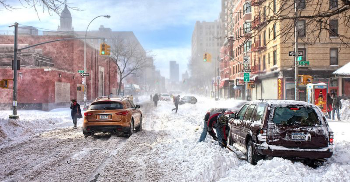
The harshest cold targets the Northern Plains, Upper Midwest, and Great Lakes first, then spills into the Ohio Valley and Northeast. Cities like Minneapolis, Des Moines, Milwaukee, and Sioux Falls are bracing for subzero lows, with daytime highs stuck in the single digits or teens. You can expect extra-brittle air that stings exposed skin, stresses engines, and tests heating systems.
As the chill reaches the I-95 corridor, places like New York, Philadelphia, Washington, and Boston will experience a sharper-than-normal plunge. Highs may cling just above freezing while nights fall into the teens or low 20s, a jarring shift for early season routines. You will notice longer warm-up times for cars and slick, refreezing sidewalks during the evening rush.
This cold is not merely inconvenient. It elevates risks for frostbite, frozen pipes, and blown fuses while potentially disrupting transit and flights. Rural areas and homes with inadequate insulation face greater challenges, so add insulation wraps to exposed pipes, allow faucets to drip, and close drafts. If you commute early, consider hand warmers and spare layers, because even brief exposure can take a toll when wind picks up.
Meteorological Drivers: Why the Cold Wave Is So Intense in Early December
This early punch of cold is rooted in the atmosphere’s steering currents. A fast-moving Alberta clipper is acting like a conveyor, dragging fresh Arctic air across the border and sweeping it through the Plains and Midwest. You feel the result at ground level, but the engine sits aloft where the jet stream dips and accelerates those compact systems.
Forecasters at The Weather Channel and other outlets note this is fitting a broader winter setup rather than a one-off cold snap. Guidance suggests the 2025-2026 season may see repeated intrusions and renewed snowfall for the Midwest, Great Lakes, and Northeast. You should think of this as a pattern signal, not a single storm headline to forget tomorrow.
Several drivers may be at work, including a wobblier jet stream and lingering La Niña influences that weaken Arctic containment. That configuration opens the door for reinforcing shots of cold, each one priming the ground and roads for faster freeze-overs. If you plan ahead now, with home checks and vehicle kits, you will be better positioned for the next surge and the one after that.
Snow and Ice – What to Expect Beyond the Cold
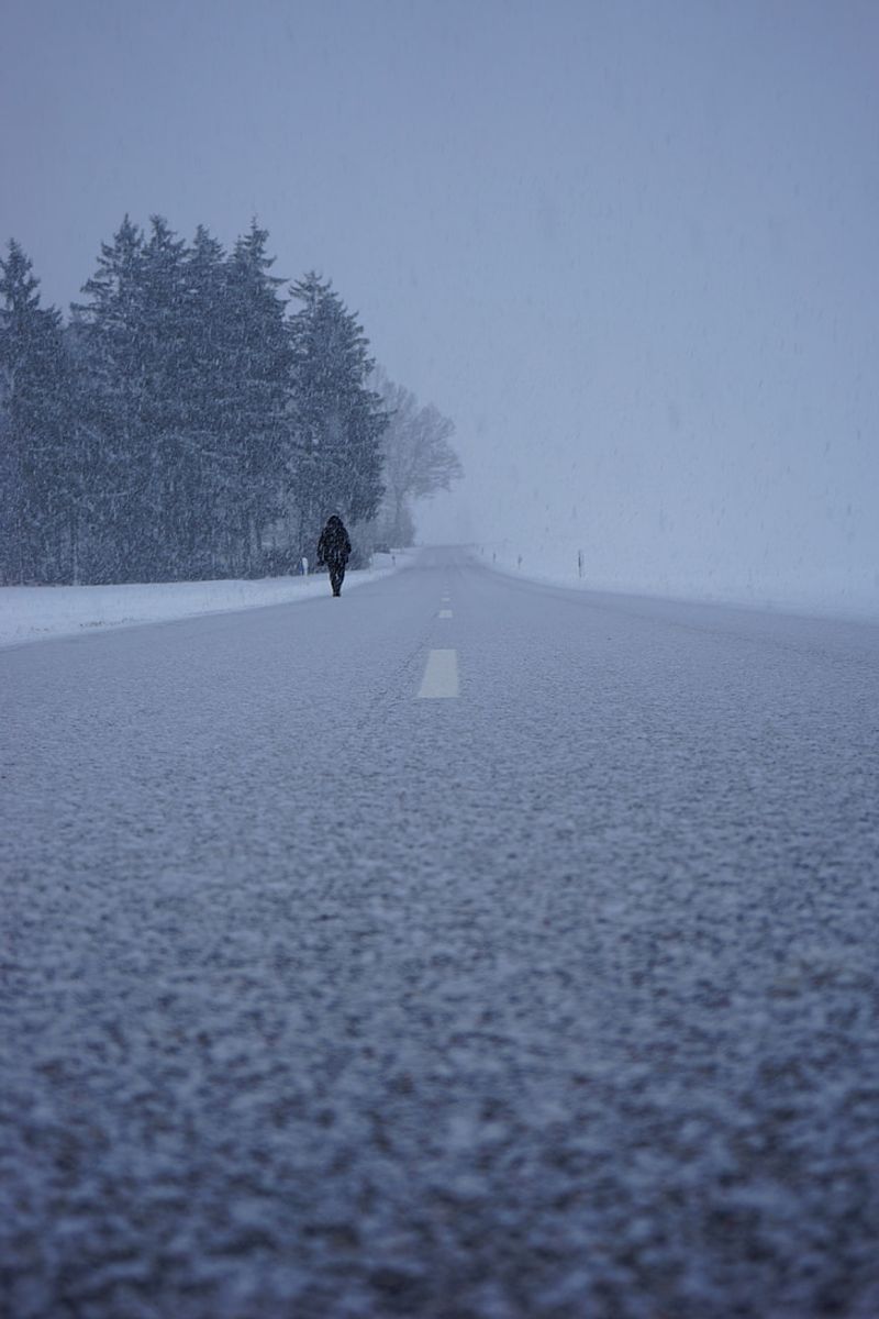
Cold gets the headline, but snow and ice decide your day. Fast-moving clippers will thread bands of light to moderate snow across the Northern Tier and Great Lakes, occasionally flaring into squalls with whiteout bursts. You could see quick coatings that turn ramps and intersections slick in minutes, especially during the morning commute.
Lake-effect streamers will blossom when Arctic air passes over warmer lakes, stacking inches in favored belts while nearby areas stay drier. Repeated events can quietly build significant totals, piling on branches and stressing power lines. If your route cuts across a snowbelt, budget extra time and carry traction aids like kitty litter or sand.
Even without fresh snow, the deep chill breeds hazards. Melt by day refreezes at night, forming black ice on bridges and side streets, while indoor pipes near exterior walls can freeze. Stay ahead with frequent forecast checks, top off windshield washer fluid, and keep a winter kit with blankets, snacks, and a phone charger. When squall warnings pop, consider delaying travel because visibility can drop to near zero in seconds.
What This Means for Winter 2025-2026: A Harsh Start to the Season
This cold wave might be the opening act for a tougher winter than many expected. Outlooks from major forecasters point to multiple cold shots and frequent snow chances in the Midwest, Great Lakes, and Northeast. You will want heating systems tuned, filters replaced, and drafty gaps sealed before the next round arrives.
Households should protect pipes, refresh emergency supplies, and map backup power plans if outages strike. Public works, transit, and utilities need to brace for higher loads and more frequent deicing cycles that strain staff and budgets. Travelers and businesses, especially in agriculture, logistics, and retail, should build in schedule buffers and review cold chain and fleet maintenance steps.
In the bigger climate picture, severe cold can still surge south despite long-term warming, thanks to large-scale dynamics that unlock Arctic reservoirs. That means volatile weeks ahead where thaws are brief and refreezes are relentless. If you prepare now with layered clothing, vehicle kits, and flexible plans, you will ride out the swings with fewer surprises and stay resilient through this season’s evolving pattern.


