California is staring down a volatile Christmas week as multiple atmospheric river storms line up across the Pacific. Forecast models are flashing signals for soaking rains, high mountain snow, and periods of strong winds just as holiday travel peaks. If you have plans on the road or in the air, timing will matter and flexibility could be your best friend. Read on to understand what is coming, where risks are highest, and how to prepare with confidence.
Major Weather Pattern Shift Expected in California Ahead of Christmas
A major pattern change is building as a corridor of Pacific moisture targets California right before Christmas. Forecast guidance shows a series of atmospheric river plumes funneling water vapor into the West Coast, priming the atmosphere for repeated waves of rain, mountain snow, and gusty winds. You will likely notice the shift through thickening clouds, milder nights, and increasingly frequent rain bands sweeping inland.
Meteorologists are watching ensemble blends from global models, including the ECMWF, for signals that central and northern California take the first, stronger hits. These rivers in the sky can wring out impressive totals in just days, recharging reservoirs and snowpack while also pushing storm drains and creeks to their limits. The Climate Prediction Center is also flagging above normal precipitation odds during Dec. 20 to 28, a window that overlaps busy travel plans.
Uncertainty remains on exact timing and intensity of each wave, but impacts often stack when storms arrive back to back. Expect higher snow levels initially, then a possible step down as colder air filters in late in the period, changing rain to heavy snow at pass level. Plan for travel disruptions, chain controls, localized flooding, and scattered power issues where winds align with saturated soils.
To stay ahead, check local NWS updates twice daily, especially if your route crosses I-80 or mountain passes. Have options ready, keep fuel topped off, and adjust plans rather than racing the weather. Small tweaks now can save big headaches later.
Atmospheric River Impacts: Rain, Snow and Flooding Risks
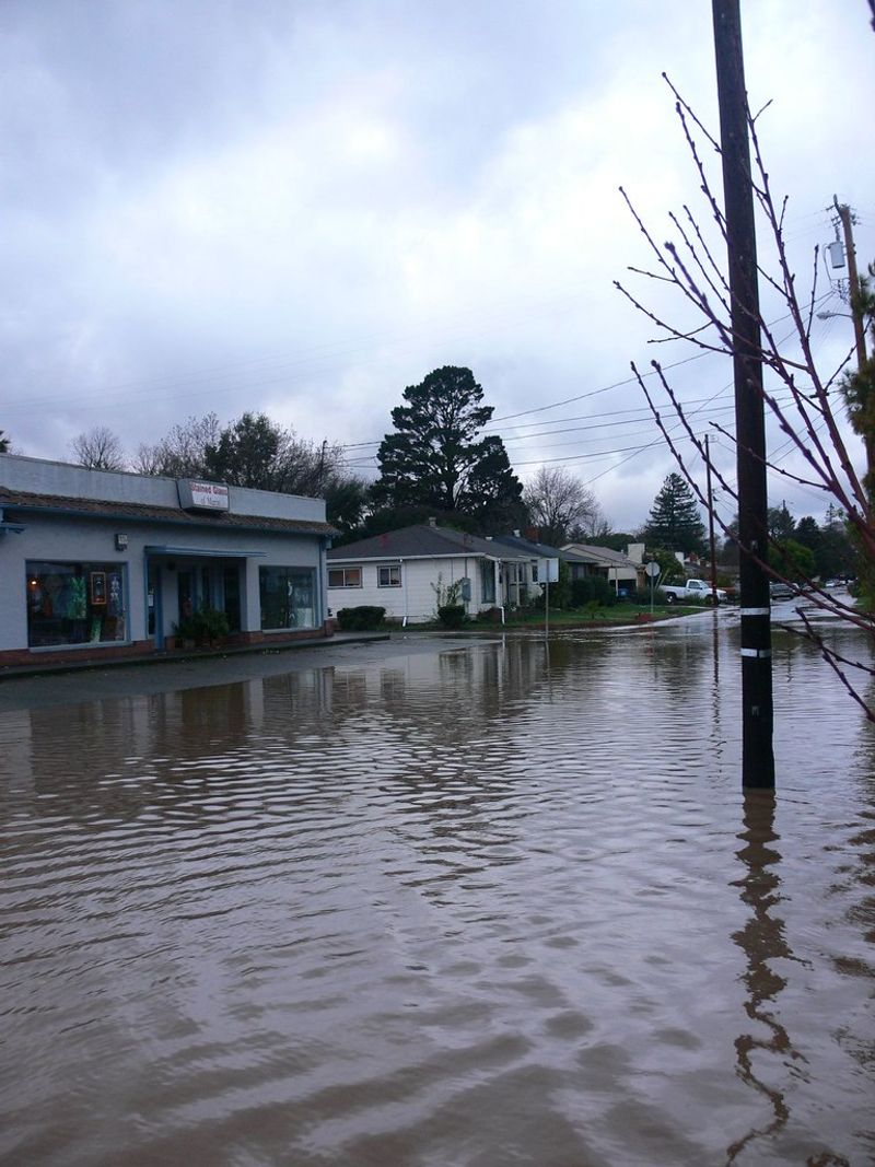
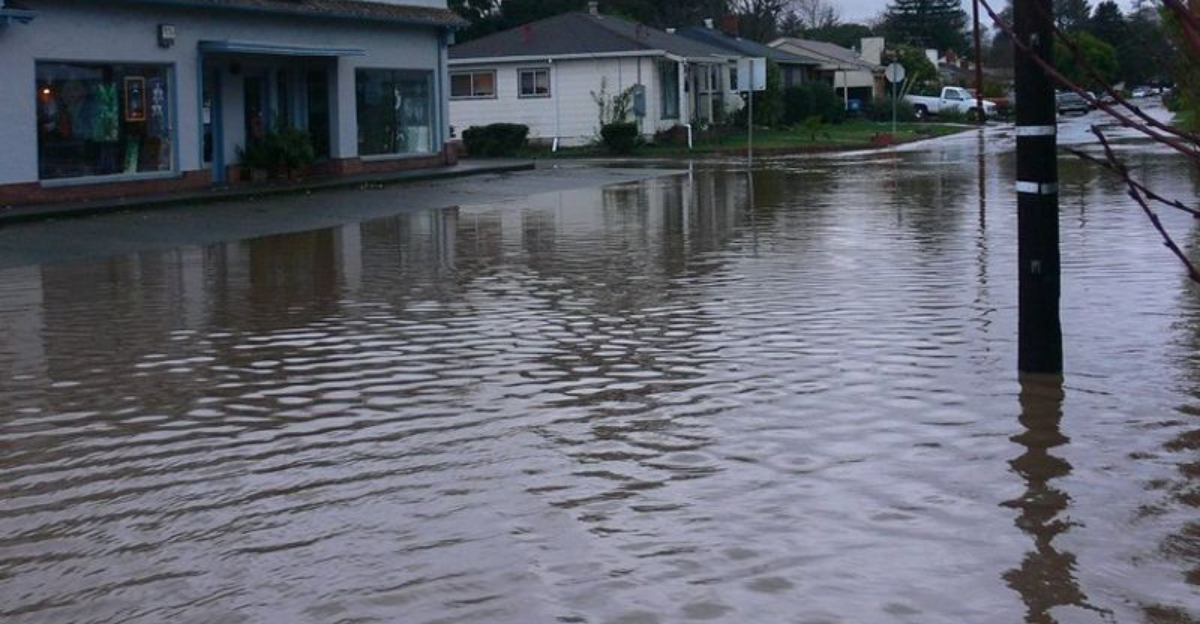
Atmospheric rivers can be both a blessing and a hazard, often within the same county. When multiple plumes arrive in quick succession, soils saturate, streams rise, and any additional burst of rain translates into faster runoff. You may see creek banks swallowed overnight while nearby ski peaks stack feet of fresh snow.
History offers perspective. The 2022 to 2023 sequence brought widespread flooding, power outages, tragic fatalities, and multibillion dollar losses across California. Pineapple Express events, drawing moisture from near Hawaii, are especially potent, with warm air boosting snow levels and sending torrential rain into valleys and foothills, while the highest Sierra still banks deep snow.
For Christmas week, expect rain at lower elevations and heavy mountain snow, particularly across the northern ranges and the Sierra Nevada. Early storms may run warm, lifting snow lines and amplifying rain impacts below about mid mountain. That combination can stress urban drainage, trigger roadway ponding, and accelerate rises on mainstem rivers and smaller tributaries.
Flood risk climbs where recent rains primed the landscape, on steep terrain, and downstream of burn scars. Local NWS offices will likely issue Flood Watches, Flash Flood Warnings, and High Wind Advisories as windows of strongest moisture transport come ashore. If you live near a creek, in a low spot, or under a slope, prep now with sandbags, clear drains, and have a go kit handy.
Travel, Safety and Preparedness for Holiday Conditions
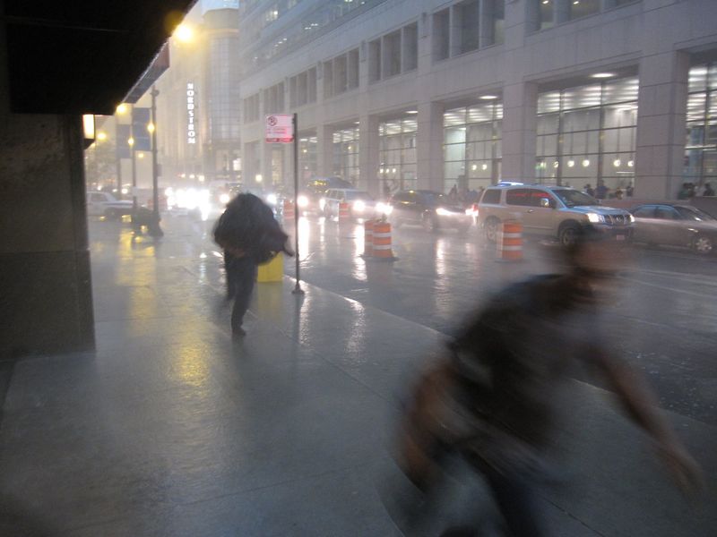
Holiday travel colliding with a storm sequence is a recipe for delays and unexpected detours. Interstates 5 and 80 traverse mountains where conditions flip quickly from wet to wintry, and chain controls can trap traffic for hours. If you are heading over the passes, assume variable visibility, slick surfaces, and sudden bursts of heavy snow.
Build a simple winter kit: tire chains, warm layers, waterproof boots, gloves, flashlight, phone charger, snacks, water, scraper, tow strap, and a small shovel. Keep fuel above half and download offline maps in case service drops. Before you leave, check Caltrans QuickMap and NWS forecasts, then add buffer time instead of pushing a risky arrival window.
In towns and cities, heavy rain can overwhelm storm drains, flooding intersections and underpasses. Never drive through water covering the road, since tire depth and current strength are easy to misjudge. If winds ramp up, expect downed branches, sporadic outages, and traffic signals on flash, so treat dark intersections as all way stops.
Recent burn scars and steep canyons are vulnerable to debris flows when rainfall intensifies. If you live downslope, park vehicles out of flow paths and stage valuables higher. For power resilience, secure batteries, keep devices charged, and know your local shelter options. Stay weather aware by enabling Wireless Emergency Alerts and saving your local NWS office page so you can pivot quickly.
Climate Context: Why Atmospheric Rivers Matter to California
Atmospheric rivers are a normal winter feature along the West Coast, yet their year to year character can swing from gentle to extreme. These moisture corridors supply a big share of California’s annual precipitation, refilling reservoirs and building snowpack that sustains water supplies through summer. When timing and intensity align, one week can reshape water outlooks for months.
Research shows a warmer atmosphere can hold more vapor, priming stronger plumes and heavier precipitation at landfall. That future points toward longer, more prolific events with expanded footprints, increasing flood risk while still delivering vital water. The same storm can rescue drought metrics and strain levees, roads, and neighborhoods within a single cycle.
California’s history is dotted with impactful AR episodes, like the 1997 New Years floods that overwhelmed levees after days of tropical moisture. Those lessons echo today as forecasters flag a Christmas week pattern shift that looks anything but routine. Benefits and hazards travel together, and your best advantage is early, practical preparation.
For communities and agencies, flexible water management, weather aware operations, and clear communication are mission critical. For you, it is about small steps: know your flood zone, insure correctly, elevate valuables, and map alternate routes before storms arrive. With sound planning, the state can harness these dynamic systems while reducing harm, keeping holiday plans safer even when the sky has other ideas.


