Christmas Eve turned chaotic across California as pounding rain overwhelmed streets, rivers, and storm drains. You could feel the urgency in every siren and evacuation alert while officials scrambled to rescue stranded drivers and families. With an atmospheric river parked overhead, the storm delivered relentless downpours, dangerous winds, and rapid flooding that upended holiday plans. Here is what you need to know right now and what to do next.
Heavy Christmas Eve Rain Triggers Flooding and Rescues Across Los Angeles Area

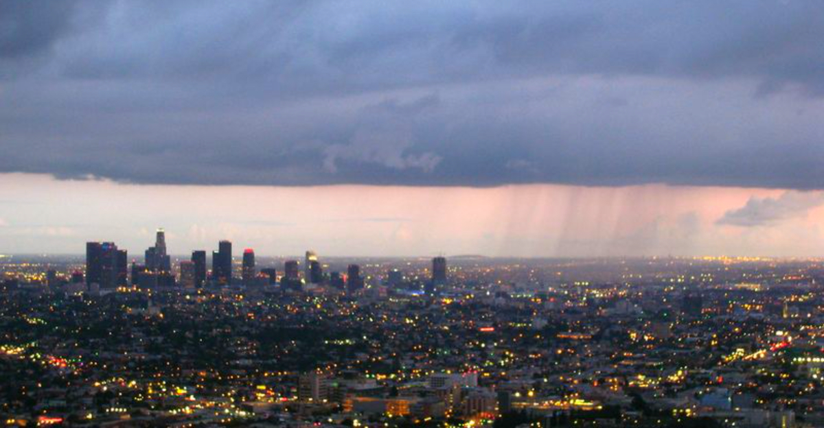
Heavy rain barrelled into the Los Angeles area on Christmas Eve, and you could see trouble build minute by minute. Water spilled off rooftops, gutters overflowed, and low-lying streets became fast-moving channels that trapped cars. Videos showed highways submerged and parking garages taking on water, a gut punch for anyone trying to get home for the holiday.
San Bernardino County mobilized more than 120 fire personnel overnight for door-to-door checks and rescues. Crews waded into waist-deep water, guided families out of flooded apartments, and pulled drivers off hood tops as currents rose. You felt the tension in every radio call, because the rain did not ease and the terrain stayed unstable.
Governor Gavin Newsom declared a state of emergency so resources could move faster and agencies could coordinate across jurisdictions. Shelters opened to give evacuees a safe, dry place to regroup while pets and medications were accounted for. Officials acknowledged the heartbreak of spending Christmas away from home and urged everyone to avoid flooded roads, follow evacuation orders, and keep phones charged.
If you are in a flood-prone zone, pack essentials, park on higher ground, and never try to drive through water. Conditions can shift fast as drains clog and hillsides loosen.
State of Emergency Declared as Atmospheric Rivers Threaten Multiple Counties

With a powerful storm fueled by atmospheric rivers marching across the state, Governor Gavin Newsom declared a state of emergency for six counties. Los Angeles, Orange, Riverside, San Bernardino, San Diego, and Shasta were prioritized so assets could surge where flooding and wind hazards stacked up. That move cleared red tape for staging swift-water teams, road crews, and utility repairs.
The National Weather Service warned of a moderate risk for excessive rainfall, and you could see it play out in flash flood advisories from San Luis Obispo to Los Angeles County. Even as bands weaken, runoff lingers and debris flows can erupt without warning. Winds of 20 to 35 mph with gusts to 55 mph added treefall risks on saturated ground, making travel treacherous.
Roughly 150,000 customers woke to outages, a reminder to keep batteries, lights, and backup charging ready. If you rely on medical devices, check your contingency plan now. Officials asked everyone to heed evacuation notices, avoid unnecessary trips, and treat every flooded crossing as closed.
Expect alerts to shift by neighborhood as creeks respond unevenly. Keep a browser tab open to local dashboards, and subscribe to text warnings so you are not caught off guard when another burst hits.
Roads Closed and Travel Disrupted as Flooding Spreads
Travel turned unpredictable as floodwaters and debris swept across key corridors in Southern and Northern California. In Los Angeles County, northbound I-5 near Lankershim saw debris wash onto lanes, forcing a temporary closure and long detours through surface streets. You could watch maps light up red as Sun Valley backups stretched for miles.
Ventura County reported multiple lane closures, while State Route 99 shut between Garden Brook Drive and Keefer Road in the north. Even shallow water hid potholes and downed limbs that could wreck tires or undercarriages. Emergency managers kept repeating the same message for a reason: turn around, do not drown.
Transportation crews worked through the night to push mud, rocks, and fallen branches off the pavement. Still, rockslides and new washouts can appear after the rain stops as slopes slump and culverts clog. If travel is essential, check Caltrans QuickMap, local CHP updates, and Waze reports before leaving.
Pack a trunk kit with water, blankets, flares, and a power bank. Keep fuel above half in case you need to reroute or idle while a closure clears. Patience helps everyone get home safer when the network is under stress.
More Rain Ahead as Officials Warn of Continued Flood and Mudslide Risks
Forecasters say the danger is not over, with additional heavy rain expected Friday into Saturday morning. A slight risk for excessive rainfall keeps flash flooding on the table, especially in cities, near creeks, and in recent burn areas. Even when the radar looks quiet, saturated soils can fail and send mud downhill fast.
Burn scars behave differently because heat-baked soils repel water, turning a modest shower into a swift, debris-laden flow. You might not see the slide starting until it is too late, which is why officials emphasize early evacuation in flagged zones. Rockfalls can also pepper canyon roads long after the heaviest band passes.
Plan for lingering disruptions to cleanups and utility work as crews navigate unstable terrain. Keep gutters clear, move valuables above floor level, and stage go-bags by the door with meds and documents. If you live below a slope, watch for cracks, leaning fences, or muddy water where it does not belong.
Meanwhile, the broader system spreads winter hazards east. The Northeast could see plowable snow, while an icy mix from Michigan through the Mid-Atlantic threatens slick commutes. Stay alert, check official feeds, and do not let a lull trick you into dropping your guard.


