
Christmas in the Bay Area is arriving with sirens, not sleigh bells. Flash flood alerts, screaming winds, and a rare tornado risk have turned a festive morning into a high-stakes weather sprint. You will want to know when to stay put, when to move, and how to prepare as waves of storms push in. Here is what matters most, broken down clearly so you can act fast and stay safe.
Flash flood warnings before dawn are not just alarming buzzes on your phone. They are life safety messages telling you to avoid traveling unless evacuating, because streets, underpasses, and creeks can fill quickly. With rain rates near one inch an hour, storm drains back up and low-lying spots flood faster than you expect.
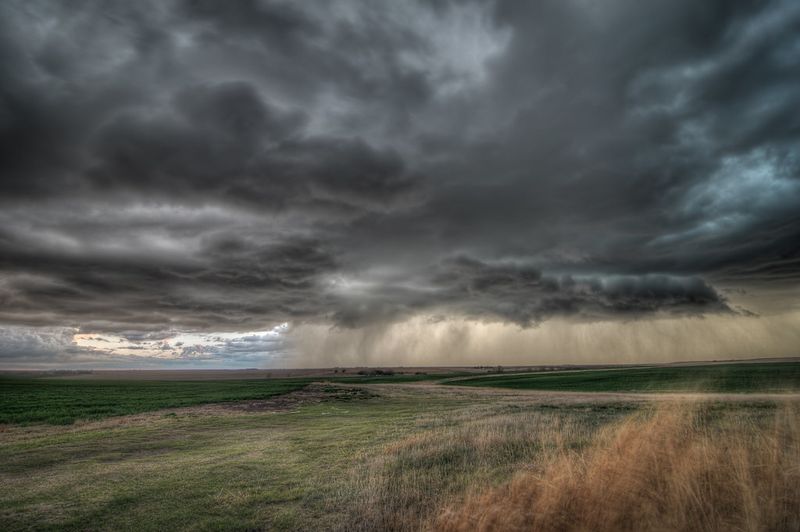
What makes this event more dangerous is the storm structure. Instead of one sloppy band, organized cells train through in waves, each one capable of dumping intense rain over a short window. That spacing helps storms keep their punch, so hazards regenerate even as breaks in the rain lull you into thinking the worst is over.
Arrival around 1 a.m. means the highest impacts overlap with darkness, when rising water and blocked roads are hardest to see. Keep devices charged and loud alerts on, especially if you live near creeks or in basement units. If water starts covering the roadway, turn around immediately. You cannot judge depth in the dark, and stalled cars become rescue scenes.
These storms are not the usual winter sheets of rain. Forecast models show spaced cells that breathe on their own, recycling wind energy and spinning up rotation. That setup can support brief tornadoes or damaging straight-line gusts, especially near the coast where southerly winds roar.
Nadocast flags a tornado-favorable environment in the North Bay, and that caught forecasters’ attention. It does not guarantee a tornado at your house, but it raises the ceiling for severe weather. The National Weather Service has a high wind warning for the coastline with gusts up to 65 mph, while Oakland and San Jose sit under advisories for gusts near 55 mph.
Tree damage, flying debris, and outages are the main worries. Park away from large limbs, secure trash bins, and bring in holiday decorations. If a tornado warning pops up, move to an interior room on the lowest floor, away from windows, and cover your head. Even short-lived spin-ups can scatter shingles and snap branches in seconds.
The worst arrives while most people sleep, then lingers into Christmas Day with on-and-off bursts. It feels like last week’s blow, but it is a different engine driving similar hazards. Wind is the headline, with a window of greatest concern from late evening through pre-dawn.
Along the immediate coast from Point Arena to Monterey, brief tornadoes are most plausible between roughly 11 p.m. and 5 a.m. Keep phones charged and within reach so warnings break through Do Not Disturb. If you rely on medical devices or elevators, plan for outages and have backups ready.
Heavy rain on saturated hillsides means quick runoff and a heightened slide risk. Even if one round passes and skies lighten, the next cell may already be forming upstream. Do not move barricades, and do not assume a cleared roadway stays safe. Reassess conditions often, check creek cameras or gauges if available, and leave early if evacuation guidance arrives.
Clear skies after sunrise can be a trap. Officials warn the calm is temporary, with another punch expected overnight into Christmas morning. Coastal gusts topped 60 mph last night, and similar power may return, so assume trees and saturated soils are primed for more failures.
Tornadoes are rare here, but the pattern is unusually supportive, which is why this round stands out. Still, non-tornadic winds are the most likely culprits for damage. Secure patio furniture, wreaths, and bins, park away from big trees, and charge battery packs. Avoid driving during peak hours when hydroplaning and downed lines are likely.
Overnight storms are uniquely risky because you cannot see pooling water or dangling wires. Set weather alerts, share plans with family, and keep a go bag with meds, lights, and copies of key documents. After the first wave, stay prepared for more. Crews need clear roads, and you need flexibility if conditions degrade quickly.


