California is bracing for a messy stretch of weather as storms line up over the Pacific and push ashore in rapid succession. You will likely see rain arrive in rounds, with little time for drainage systems to catch up or for soils to dry out. That one-two punch means higher flood risk, tougher travel, and more power disruptions than a single storm might cause. Read on to learn what to watch for and how to stay safe as conditions evolve.
Successive Pacific storms are funneling deep moisture into California, delivering repeated rounds of heavy rain, gusty winds, and mountain snow. Because each wave arrives before rivers and soils can recover, runoff accelerates and low spots fill faster than usual. You will notice storm drains backing up and small creeks responding quickly as the week progresses.
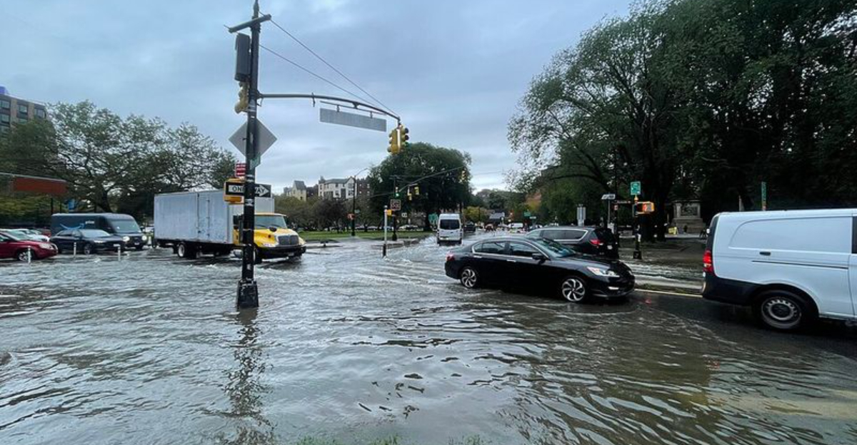
Meteorologists point to a persistent west-to-southwest flow as the conveyor belt driving these impacts. Central and Southern California face the greatest concern, where intense downpours can overwhelm urban infrastructure and trigger localized flash flooding. Even neighborhoods that rarely flood may see water ponding at intersections and in underpasses.
The compounding effect matters most. Every additional inch of rain piles onto saturated ground, raising the odds of road washouts, small landslides, and slope failures. Plan on slower commutes, scattered power outages, and changing advisories.
If you live near a creek, a hillside, or a poorly drained area, move valuables off floors and keep devices charged. Check gutters, clear grates, and avoid parking beneath unstable slopes. Stay flexible with travel until the storm train finally breaks.
Flash flooding becomes more likely when intense rain falls on pavement, compacted soils, or burn scars. In cities, water can rise within minutes, filling underpasses and low-lying neighborhoods before you have time to turn around. Storm drains may appear clear, then suddenly surge and push water back onto roads.
Burn scars are especially dangerous because fire-baked soils repel water, sending runoff racing downhill. Debris flows can start with a burst of rain and carry rocks, branches, and mud that move faster than you can run. If you are near a past wildfire area, be ready to evacuate at the first warning.
Overnight is risky because hazards are harder to spot. Keep alerts enabled, avoid sleeping in lower levels if flooding is possible, and pre-pack essentials. Do not drive across flooded crossings or around barricades.
Know your routes and identify higher ground before storms hit. If water rises, move quickly and call for help only when safe. Your best protection is leaving early, not challenging fast-moving water.
Expect slower commutes, pop-up closures, and long detours as rain, debris, and standing water complicate roads. Hydroplaning risk spikes during the first minutes of a downpour when oil lifts from pavement. Give extra space, reduce speed, and use headlights to stay visible.
Mountain passes will see periods of heavy snow and reduced visibility. Chain controls or full closures can be issued with little notice, so check pass conditions before you go. Winds strong enough to down trees and power lines may also block lanes and intersections.
Air travel can stagger as rain bands and gusts roll through major hubs. Delays may extend after skies clear due to aircraft repositioning and runway cleanup. Build in flexible connections and track your flight in airline apps.
If the forecast highlights your route, consider shifting departure times or postponing nonessential trips. Store a winter kit in the car with water, snacks, warm layers, and a phone charger. Emergency crews might be stretched thin, so self-sufficiency helps until help arrives.
Even after the first storms pass, the pattern may stay unsettled, keeping soils saturated and creeks high. That means lingering flood risk and renewed problems if another system arrives. Breaks in the rain can feel reassuring, but runoff often lags and slopes can remain unstable.
Stay plugged into local alerts, NOAA weather radio, and city updates for evacuation notices and roadway changes. Prepare a go-bag with medications, chargers, water, and copies of key documents. Secure outdoor furniture and trash bins so winds and water do not turn them into hazards.
Complacency is the quiet threat between rounds. If you live near a floodplain or hillside, review your plan and know multiple exit routes. Keep vehicles fueled and park where rising water cannot reach.
California needs winter precipitation, but extreme bursts can turn dangerous fast. Your caution now protects your home and helps first responders focus where they are needed most. Stay ready until forecasters confirm the storm train has finally shifted away.


