A fast developing storm system is putting parts of the United States on alert as the tornado risk ramps up. You will likely notice the sky turning turbulent quickly, with storms capable of intensifying in minutes.
Forecast guidance points to a volatile mix of warm moisture and strong winds aloft that can spin up dangerous thunderstorms. Stay with this guide to understand what is coming, what to watch for, and how to get ready now.
Meteorologists are tracking a powerful upper level disturbance colliding with warm, moisture rich air, a setup that often breeds severe thunderstorms. You could see storms fire rapidly with limited warning time, especially during late afternoon into nighttime hours.
The risk zone stretches across parts of the Plains, the lower Mississippi Valley, and the Southeast, where instability is increasing and wind fields are strengthening.
Not every community will see tornadoes, but isolated events can be devastating, particularly if storms move fast or hit after dark. Quick moving cells can outpace sirens and social media feeds, so multiple alert methods matter.
If you live in manufactured homes or rural areas with scarce shelter options, plan now for where you will go when a warning is issued.
Have footwear, helmets, and chargers ready so you can move quickly. Bring pets and medications into your safe space before storms arrive.
Remember that even brief tornadoes can peel roofs, snap trees, and scatter debris like shrapnel. The most dangerous moment is hesitation, so decide your safe room today.
Keep phones charged, enable wireless alerts, and know your county names.
Supercells thrive when the atmosphere stacks warm, humid air near the ground beneath strong, veering winds aloft. That wind shear tilts and stretches updrafts until storms begin to rotate, a process you might spot as a persistent wall cloud.
When that rotation tightens near the surface, tornadoes can spin up quickly, sometimes with little visual warning beyond swirling dust or sudden power flashes.
Instability is the fuel, shear is the engine, and a lifting boundary focuses the ignition. Along a front or dryline, parcels rise, cool, and condense, building towering cumulonimbus with vigorous updrafts.
Hail cores grow large as stones cycle through the storm, and lightning intensifies as charge separates within the turbulent cloud.
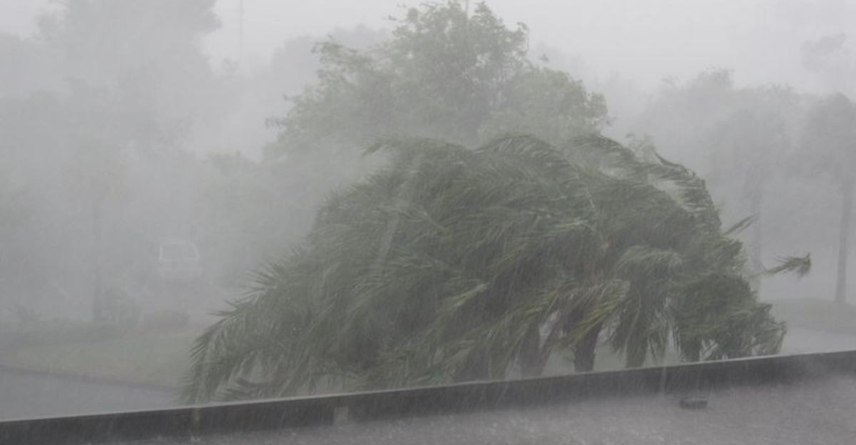
Damaging straight line winds can rival tornado impacts, toppling trees, ripping shingles, and knocking out power. You may only get a few minutes between a severe thunderstorm warning and a tornado warning if the storm evolves.
Treat any rotating storm with urgency. If skies darken and wind shifts abruptly, move to your safe place.
Keep a radar app and NOAA Weather Radio handy so you can react to rapid changes without delay.
Severe storms that can produce tornadoes often disrupt far more than the immediate path of damage. Strong winds may drop trees across roads, while heavy rain reduces visibility to near zero.
You might encounter flooded intersections, dark traffic signals, and scattered debris that makes travel hazardous within minutes of a warning.
Drivers should avoid the road when warnings are active, especially at night when hazards hide in the rain. High profile vehicles are vulnerable to crosswinds and sudden gusts near convective cores.
Air travel can also snarl as storms skirt major hubs, leading to delays, diversions, or ground stops that ripple through schedules for hours.
Before storms arrive, charge phones and battery packs, secure patio furniture, and park vehicles away from trees. Utilities often pre position crews, but restoration takes time if lines are down across large areas.
Keep a basic kit with water, snacks, flashlights, and medications for at least 24 to 48 hours. If power fails, avoid downed wires and use generators outside.
A little preparation now saves stress when the sky turns ugly.
Tornado risk is no longer just a spring storyline, and that shift changes how you prepare. Transitional seasons, and even winter warmups, can bring sharp collisions of air masses that trigger severe storms.
Staying weather aware year round matters, especially when a quick hitting system approaches on a day that does not feel like classic tornado weather.
Have multiple alert methods, including smartphone notifications and a NOAA Weather Radio with fresh batteries. Nighttime storms are extra dangerous because you might be asleep when warnings arrive.
Identify your home’s safest spot, ideally a basement or interior room on the lowest floor away from windows, and practice getting there quickly.
If you live in a mobile home, arrange a plan to relocate to sturdier shelter when watches are issued. Stock helmets, sturdy shoes, flashlights, and copies of critical documents in your safe space.
Do not wait for sirens or visible rotation to act, because severe storms can intensify rapidly. Treat watches as your cue to review plans and warnings as the signal to move.
Early, decisive action saves lives.


