America is packed with jaw-dropping landscapes that seem almost too beautiful to be real. From towering canyon walls to crystal-clear coastlines, these stunning spots offer views that belong on the front of a postcard.
Whether you’re planning your next road trip or just daydreaming about adventure, these fifteen destinations will make you want to grab your camera and hit the road right away.
1. Going-to-the-Sun Road, Glacier National Park (Montana)
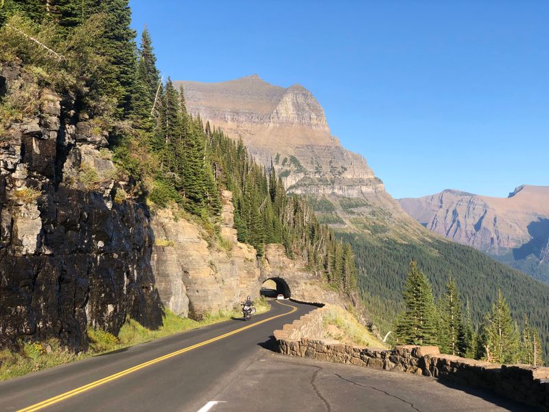
Carved into the mountains with engineering genius, this legendary road delivers one breathtaking view after another. Glacier-carved peaks tower overhead while turquoise lakes shimmer below, making every curve feel like a scene from an adventure movie.
The road itself becomes the destination, not just a path to somewhere else.
Logan Pass sits at the top, offering high-alpine scenery that feels otherworldly when accessible. Wildflowers blanket the meadows in summer, and mountain goats often wander near the parking areas.
Pack layers because temperatures can drop quickly at higher elevations.
Plan ahead since the road typically opens in late June or early July and closes by mid-October. Snow lingers long into summer at the highest points, creating a short but spectacular season.
Arrive early in the morning to snag parking and avoid midday traffic jams.
2. Tunnel View and Glacier Point, Yosemite National Park (California)
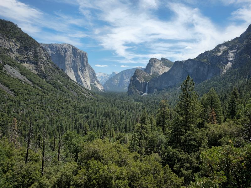
Pull into Tunnel View and prepare to have your breath stolen. This famous overlook frames Yosemite Valley perfectly, with El Capitan standing guard on the left and Bridalveil Fall cascading on the right.
Half Dome rises majestically in the distance, completing a scene photographers dream about.
Glacier Point takes the experience even higher, literally. From this commanding viewpoint, you can see Yosemite Falls, Half Dome, and the high country stretching endlessly.
Seasonal road access means planning is essential, but the reward is worth every bit of effort.
Sunrise and sunset transform both locations into pure magic, painting the granite cliffs in shades of gold and pink. Arrive early to claim parking spots, especially during summer months.
Bring a wide-angle lens if you’re into photography because the views are massive.
3. Mather Point (South Rim), Grand Canyon National Park (Arizona)
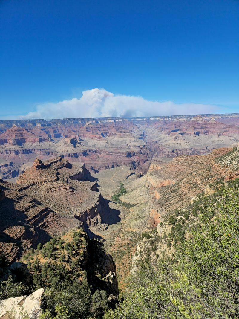
Most visitors experience their first Grand Canyon moment right here. Just a short walk from the visitor center, Mather Point delivers an expansive view that makes you feel incredibly small yet strangely connected to something ancient.
Layers of red, orange, and purple rock stretch for miles in every direction.
The South Rim stays open year-round, making it the most accessible section for travelers visiting during any season. Winter brings snow-dusted canyon edges, while summer offers long daylight hours for exploration.
Each season paints the canyon in different colors and moods.
Sunrise offers softer light and thinner crowds, perfect for soaking in the silence and grandeur. Watching the sun creep across the canyon walls creates shadows that reveal hidden depths and textures.
Bundle up for early morning visits because desert temperatures can surprise you.
4. The Narrows, Zion National Park (Utah)
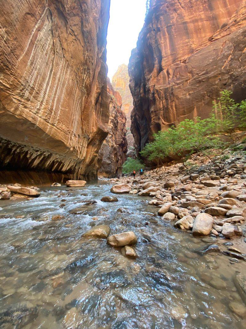
Walking through water between towering canyon walls feels like stepping into another dimension. The Virgin River flows through the narrowest section of Zion Canyon, creating a hiking experience unlike any other in America.
Sunlight filters down from high above, illuminating the red rock in stunning ways.
Conditions change quickly here, so checking water levels and flash-flood alerts before heading out is absolutely essential. Some days the river runs gentle and shallow, while other times it becomes too dangerous for entry.
Water shoes and a walking stick make navigating the rocky riverbed much easier.
The deeper you venture into the canyon, the narrower and more dramatic it becomes. Walls rise hundreds of feet overhead, sometimes blocking out the sky entirely.
Plan for wet feet and bring a waterproof bag for cameras and phones.
5. Sunrise Point, Bryce Canyon National Park (Utah)
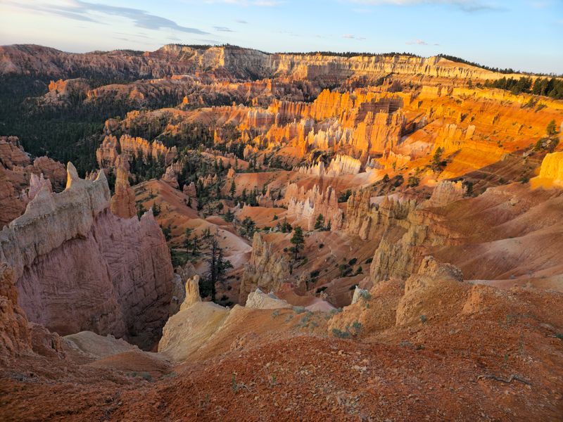
Don’t let the name fool you because this overlook shines beautifully at both sunrise and sunset. Perched at about 8,100 feet, Sunrise Point gazes down into the famous Bryce Amphitheater, where thousands of hoodoos stand like a frozen army.
The formations glow orange and red when light hits them just right.
Daybreak brings softer colors and cooler temperatures, perfect for photographers chasing that golden-hour magic. Evening light creates longer shadows that emphasize the hoodoos’ strange shapes and textures.
Either time offers a completely different mood and color palette.
After dark, the wide-open views make this spot excellent for stargazing. With minimal light pollution and high elevation, the Milky Way often stretches brilliantly overhead.
Dress warmly because temperatures drop significantly after sunset, even in summer months.
6. Trail Ridge Road, Rocky Mountain National Park (Colorado)
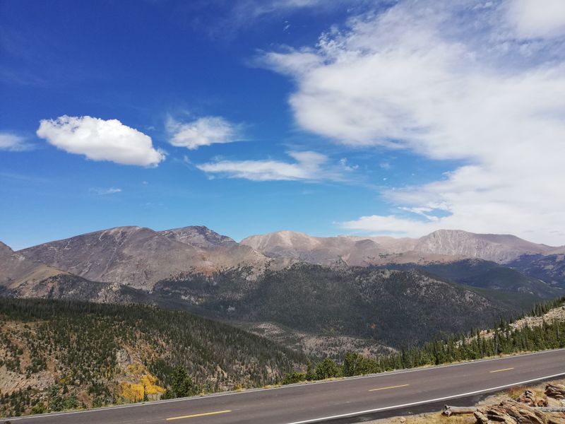
Nicknamed a highway to the sky, this road climbs above the treeline into a landscape of pure mountain majesty. Huge, open-sky views stretch across the Rockies in every direction, making you feel surrounded by peaks and clouds.
Alpine tundra spreads across the high country, dotted with tiny wildflowers during brief summer weeks.
The road reaches over 12,000 feet at its highest point, offering a rare chance to drive into true alpine terrain. Bighorn sheep and elk often graze near the roadside, especially during early morning hours.
Pull into overlooks frequently because each one reveals a slightly different perspective.
This scenic route operates seasonally, typically opening in late May and closing by mid-October depending on snowfall. Check the park’s website for current opening and closing dates before planning your trip.
Afternoon thunderstorms are common in summer, so start early.
7. Cadillac Mountain Summit Road, Acadia National Park (Maine)
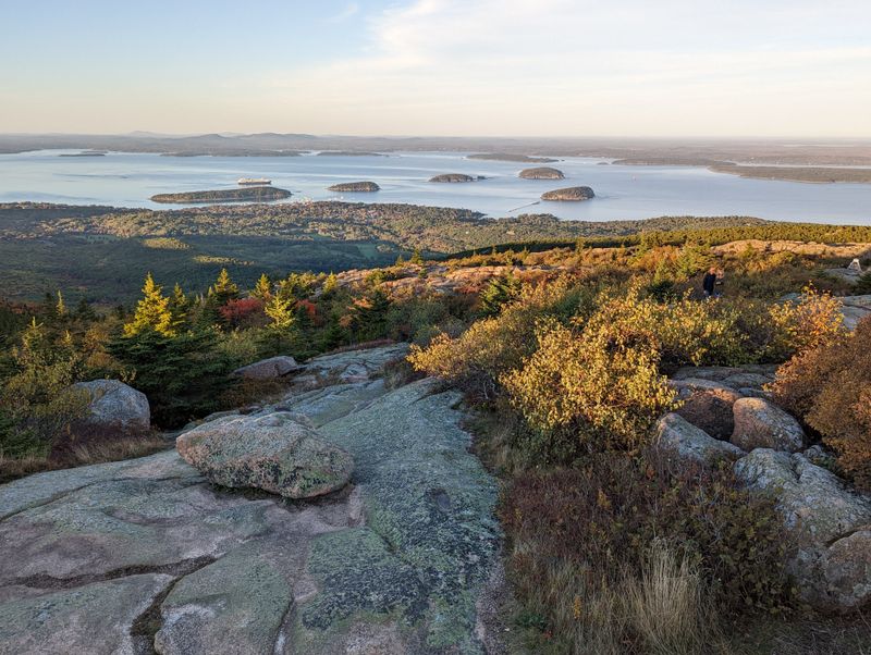
Standing atop Cadillac Mountain feels like reaching the top of the East Coast. This iconic viewpoint offers sweeping vistas over forests, islands, and the Atlantic Ocean stretching endlessly toward the horizon.
During busy season, you’ll need a vehicle reservation to drive the summit road, separate from your park entrance pass.
Sunrise here is legendary, often considered one of the first places in the United States to see daylight. The sky transforms through shades of pink, orange, and purple as the sun climbs above the ocean.
Reservations for sunrise slots fill up fast, so book well in advance if that’s your goal.
Even outside of sunrise hours, the summit delivers incredible panoramic views worth the drive. Bring binoculars to spot boats sailing between islands or eagles soaring on ocean breezes.
Layers are essential because coastal winds can be chilly year-round.
8. Linn Cove Viaduct, Blue Ridge Parkway (North Carolina)
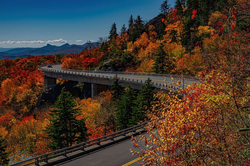
Engineering meets natural beauty at this stunning stretch of the Blue Ridge Parkway. The Linn Cove Viaduct hugs the side of Grandfather Mountain, curving gracefully around the rocky terrain in a way that looks almost impossible.
It’s one of the parkway’s most photographed structures for good reason.
Driving across the viaduct feels like floating through the mountains, with forest dropping away on both sides. A visitor center and trail near the viaduct let you view the structure from below, revealing its elegant design.
Autumn transforms the surrounding forests into a blaze of red, orange, and gold.
Weather, construction, or emergencies can cause temporary parkway closures, so check the NPS road status before heading out. Spring brings blooming rhododendrons and dogwoods, while summer offers lush green canopies.
Each season paints the viaduct in a completely different palette.
9. Grandview Main Overlook, New River Gorge National Park & Preserve (West Virginia)
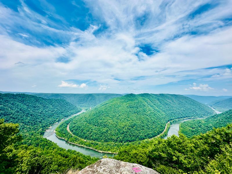
Prepare for that unexpected moment when you realize West Virginia hides serious canyon drama. Grandview delivers exactly what its name promises, with a sweeping overlook above the New River that feels massive and wild.
The gorge drops away dramatically, revealing layers of forest and rock carved by ancient water.
Late afternoon light makes the canyon walls pop with color and texture, creating shadows that emphasize the depth. Watching hawks and vultures soar below the overlook rim adds to the sense of height and scale.
Bring a telephoto lens if you want to capture details of the river far below.
The overlook sits within a short walk from the parking area, making it accessible for most visitors. Interpretive signs explain the geology and history of this impressive gorge.
Spring and fall offer comfortable temperatures and stunning seasonal colors throughout the surrounding forest.
10. Fort Jefferson (Garden Key), Dry Tortugas National Park (Florida)
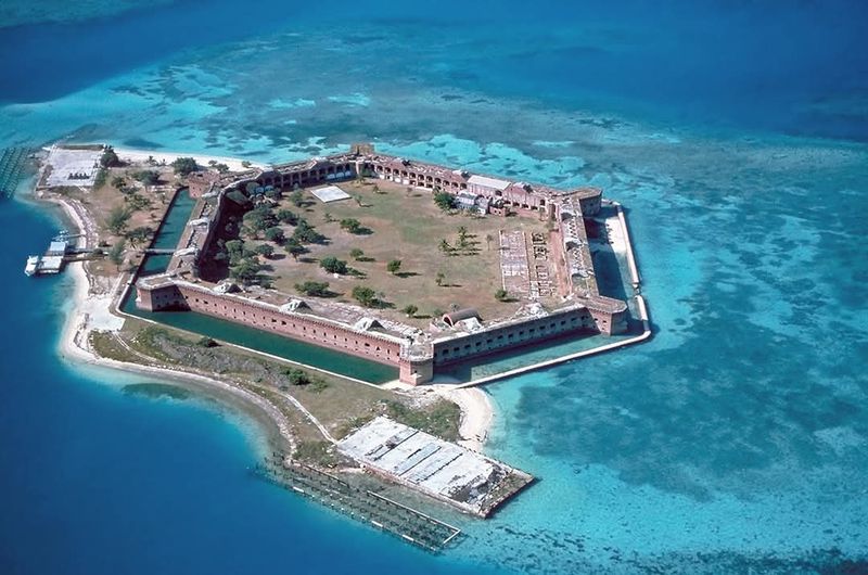
Remote, surreal, and surrounded by water so blue it barely looks real. Fort Jefferson rises from Garden Key like something from a tropical dream, its massive brick walls contrasting brilliantly against turquoise Caribbean waters.
Getting here requires a boat ride or seaplane, but the journey becomes part of the adventure.
The Yankee Freedom ferry and Key West seaplane charters offer common access options to reach this isolated paradise. Once you arrive, snorkeling reveals vibrant coral reefs teeming with tropical fish just offshore.
Sea turtles often glide past swimmers, completely unbothered by human visitors.
The fort itself holds fascinating Civil War history, and exploring its corridors and ramparts takes hours. Photographers find endless angles where historic brick meets brilliant ocean blue.
Pack reef-safe sunscreen, plenty of water, and underwater camera gear for an unforgettable day trip.
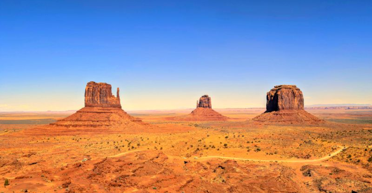
11. Monument Valley Navajo Tribal Park (Arizona/Utah)
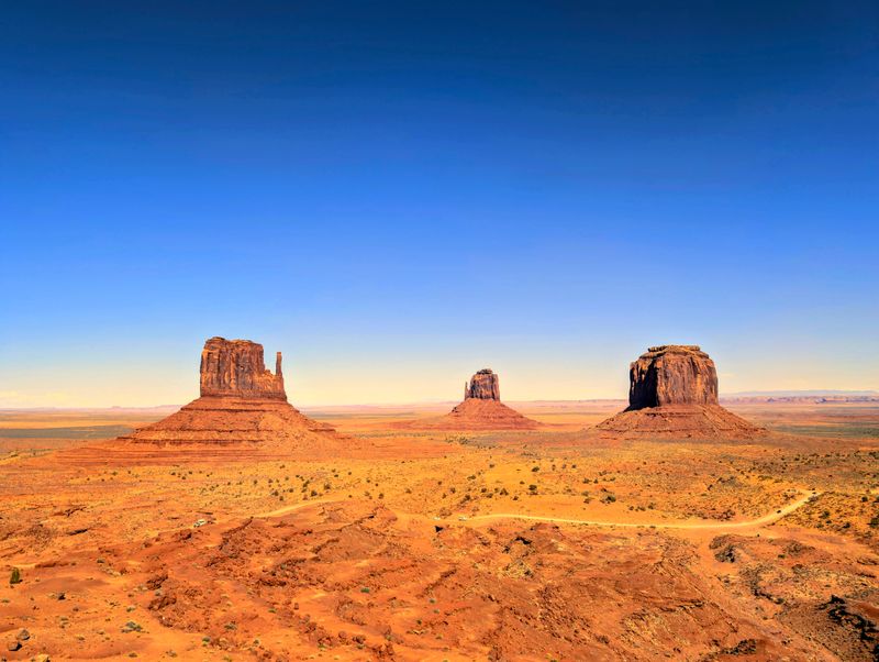
These towering red formations define the classic American West in ways nothing else can. Monument Valley’s massive buttes and mesas rise dramatically from the desert floor, creating silhouettes that have starred in countless movies and photographs.
The Navajo Nation manages this sacred landscape, and the seventeen-mile loop drive offers the primary way to experience the scenery.
Sunrise and sunset paint the formations in constantly shifting shades of red, orange, and purple. Shadows stretch long across the valley floor, emphasizing the height and grandeur of each tower.
Dust kicked up by wind adds atmospheric haze that makes photos look almost painterly.
This is Navajo Nation land, so respecting park rules and following any posted advisories is essential. Guided tours led by Navajo guides offer deeper access and cultural insights beyond the main loop.
Bring plenty of water because the desert heat is intense year-round.
12. Kalalau Lookout, Kōkeʻe State Park (Kauaʻi, Hawaiʻi)
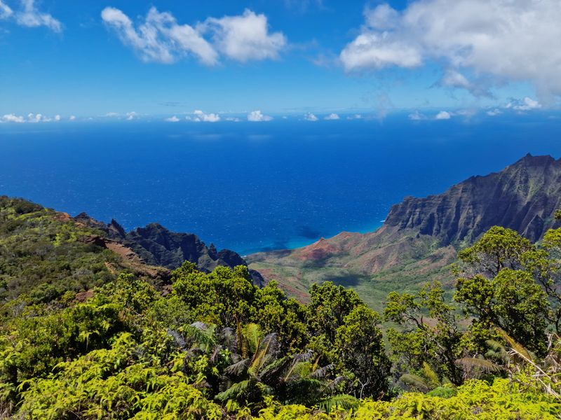
Many travelers call this the postcard view of Kauaʻi, and one glance explains why. Kalalau Lookout offers big, sweeping vistas toward Kalalau Valley and the legendary Nā Pali Coast, where emerald cliffs plunge dramatically into the Pacific.
Clouds often drift through the valley below, creating an ever-changing landscape.
The drive up to Kōkeʻe State Park climbs through multiple climate zones, from coastal warmth to cool mountain air. Roadwork occasionally affects Kōkeʻe Road, including the stretch near Kalalau Lookout, so checking for access updates before visiting is smart.
Morning light often provides clearer views before afternoon clouds roll in.
Bring a jacket because temperatures at this elevation feel much cooler than the beaches below. Multiple lookouts line the road, each offering slightly different perspectives of the valley and coast.
Binoculars help spot waterfalls cascading down distant cliffs.
13. Haystack Rock, Cannon Beach (Oregon)
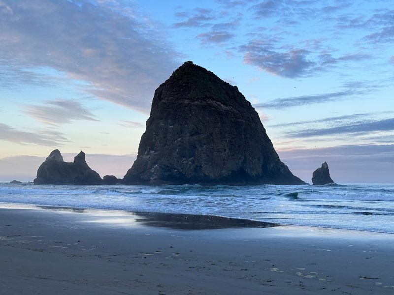
Rising about 235 feet above the shoreline, Haystack Rock commands attention from every angle. This towering sea stack ranks among the Oregon Coast’s most instantly recognizable landmarks, appearing in countless photos and paintings.
Waves crash dramatically around its base during high tide, while low tide reveals fascinating tidepools teeming with life.
Visit during low tide for the best experience, when colorful sea stars, anemones, and crabs populate the exposed rocky pools. Interpretive programs run seasonally, offering guided tidepool explorations led by knowledgeable volunteers.
Puffins nest on the rock during summer months, delighting birdwatchers with binoculars.
The beach stretches wide and sandy, perfect for long walks with the rock as your constant backdrop. Sunset paints the sky in brilliant colors, silhouetting Haystack Rock against orange and pink horizons.
Bring waterproof shoes if you plan to explore tidepools closely.
14. Badlands Loop Road and Big Badlands Overlook, Badlands National Park (South Dakota)
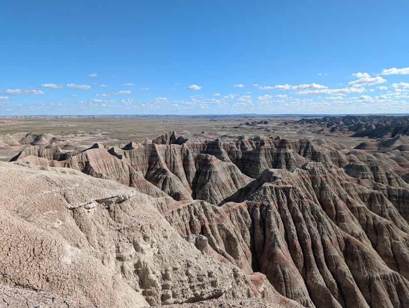
Badlands Loop Road strings together one jaw-dropping overlook after another, creating a scenic drive that never gets boring. Each pullout reveals a different perspective on the dramatically eroded landscape, where layered rock formations display millions of years of geological history.
The colors shift from tan to red to purple depending on light and time of day.
Big Badlands Overlook stands out as one of the classic stops, offering a wide view over the Badlands wall and surrounding formations. The landscape looks almost alien, like something from another planet rather than South Dakota.
Bison often graze in the grasslands below, adding movement to the ancient scenery.
Early morning and late afternoon provide the best light for photography, when shadows emphasize the dramatic textures. Summer heat can be intense, so carry water and wear sun protection.
Wildlife viewing opportunities abound throughout the park, including bighorn sheep and prairie dogs.
15. Santa Elena Canyon Trail, Big Bend National Park (Texas)
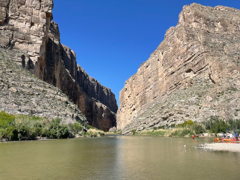
Santa Elena Canyon ranks among Big Bend’s most dramatic destinations, where the trail winds toward the Rio Grande and towering canyon walls close in overhead. The NPS notes this as one of the narrowest sections of the seven-mile-long canyon, creating an almost cathedral-like atmosphere.
Limestone cliffs rise 1,500 feet above the river, dwarfing everything below.
The trail involves wading through Terlingua Creek before reaching the canyon entrance, adding a splash of adventure to the hike. Once inside, the temperature drops noticeably as shade from the massive walls provides relief from desert heat.
The river flows quietly here, reflecting the towering cliffs in its calm surface.
Big Bend occasionally has temporary closures for management operations, but Santa Elena Canyon typically remains accessible. Always check current alerts before making the drive since the canyon sits far from park headquarters.
Bring water shoes and expect your feet to get wet during the creek crossing.


