The Aral Sea, once the fourth-largest lake on Earth, stretched across hundreds of miles and supported thriving ecosystems and communities through fishing and agriculture.
In just a few decades, however, the lake nearly vanished, losing 90% of its water and leaving behind a barren desert scattered with rusting ships. This dramatic environmental catastrophe remains one of the clearest examples of how human activity can reshape the planet.
Once the Fourth-Largest Lake in the World
Before the 1960s, the Aral Sea was a giant among lakes, measuring an incredible 420 kilometers long and 280 kilometers wide. Its sheer size earned it the poetic nickname “Sea of Islands” because of the many small islands scattered across its surface.
Sailors and fishermen navigated its waters, which covered an area larger than some entire countries.
The lake sat in the heart of Central Asia, bordered by Kazakhstan to the north and Uzbekistan to the south. Two major rivers, the Amu Darya and Syr Darya, fed fresh water into the sea, maintaining its delicate balance.
The surrounding communities depended on this water source for drinking, irrigation, and fishing.
At its peak, the Aral Sea held enough water to fill millions of Olympic swimming pools. The climate around the lake was moderated by its massive size, creating a unique environment where life flourished.
Local cultures developed around the sea, with generations of families making their living from its bounty.
Nobody imagined that within a single human lifetime, this ancient body of water would nearly vanish. The transformation from thriving lake to desert wasteland would become one of history’s greatest environmental disasters.
Stranded Ships in the Desert
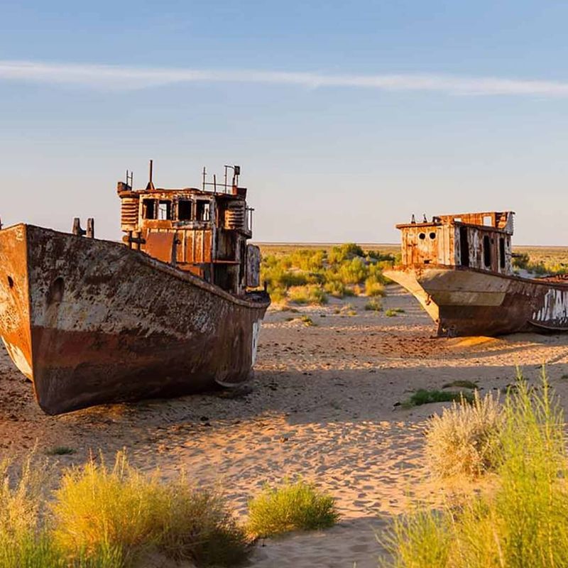
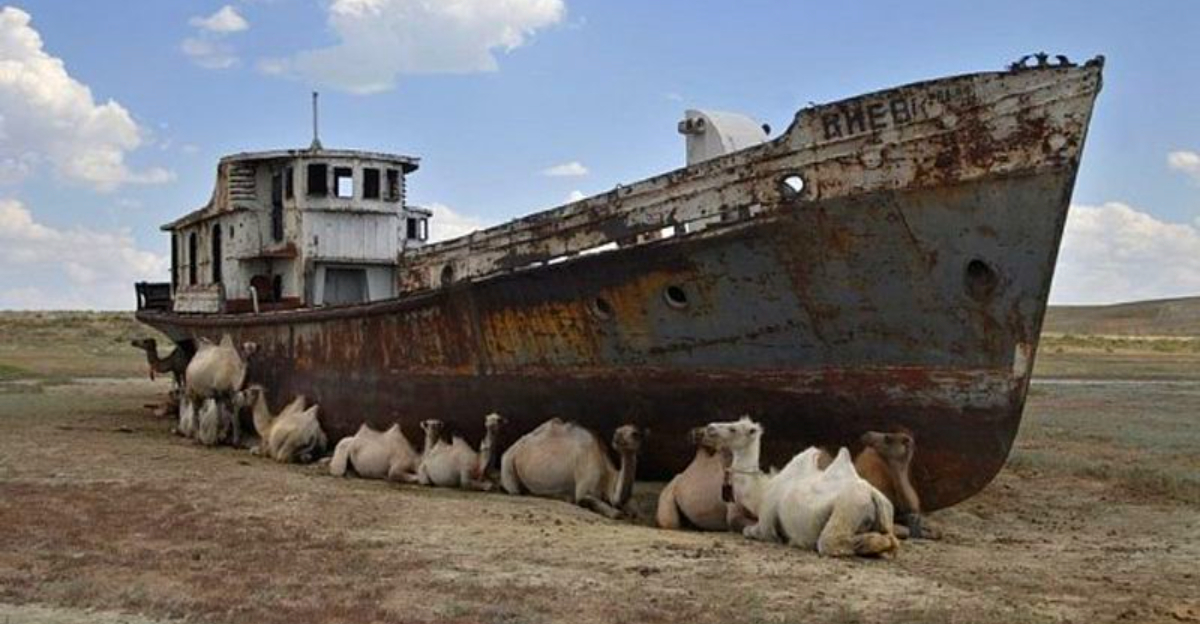
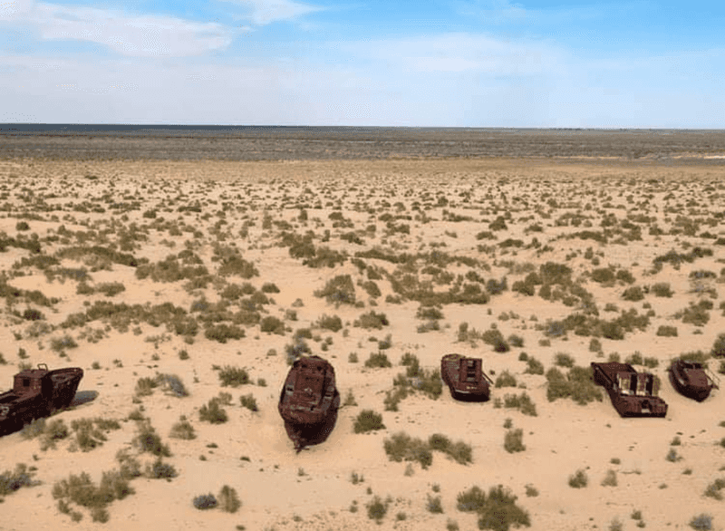
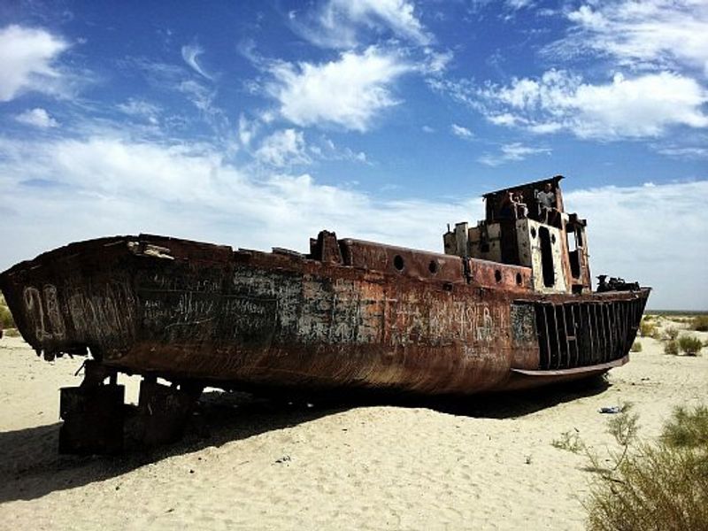
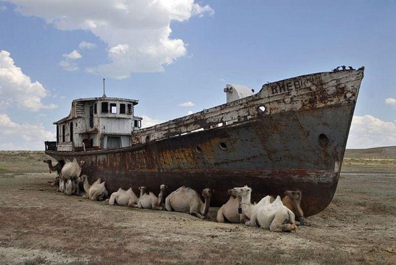
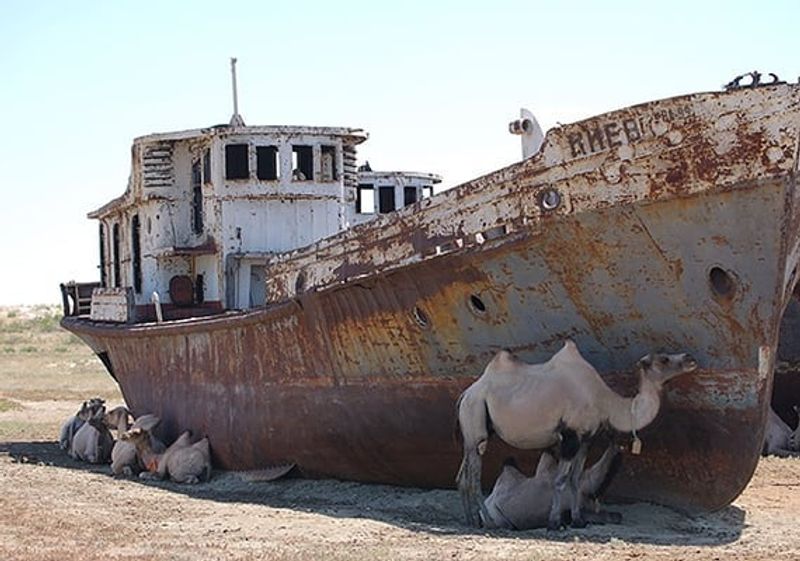
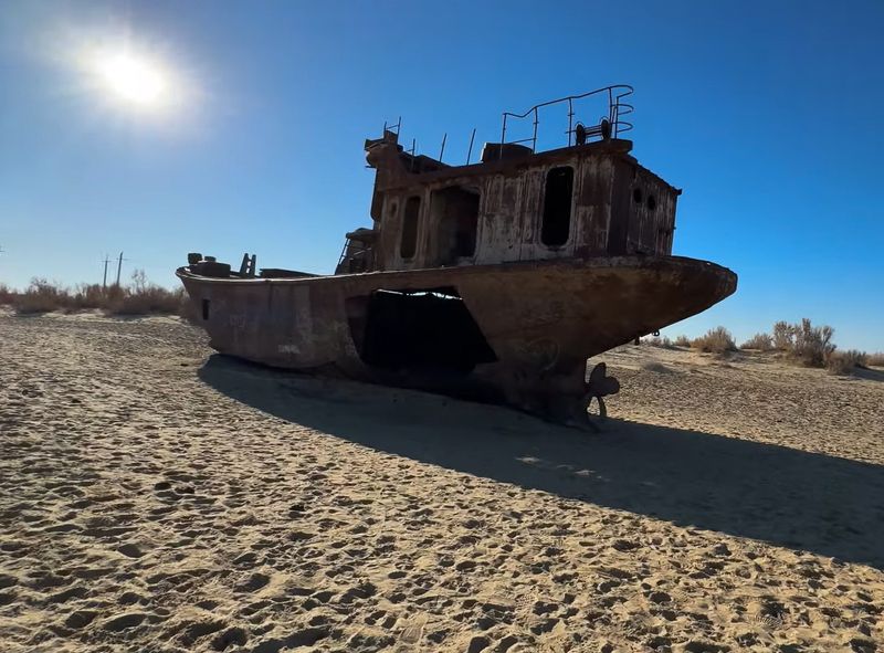
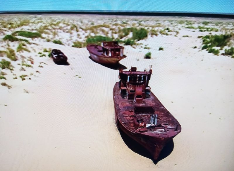
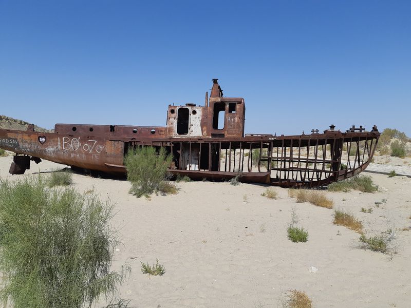
Picture massive fishing vessels sitting motionless on dry sand, miles from any water. This surreal scene has become the haunting signature image of the Aral Sea disaster.
Ships that once carried tons of fish now rest as rusting monuments in what locals call the “ship graveyard.”
These abandoned boats tell a story of communities caught off guard by rapid environmental change. Fishermen who tied up their vessels one season returned the next to find the water receding further and further away.
Eventually, the shoreline disappeared completely, leaving entire fleets marooned on cracked earth.
The town of Moynaq, once a bustling fishing port, now sits more than 150 kilometers from the nearest water. Tourists from around the world visit to photograph the eerie landscape where ocean-going vessels decay under the desert sun.
The corroded hulls have become powerful symbols recognized globally.
These ships serve as a warning about the consequences of environmental mismanagement. Children who play around the wrecks have never seen the lake their grandparents fished.
The rusted metal stands as a permanent reminder of what was lost when human ambition ignored natural limits.
Human Intervention Caused the Collapse
During the 1950s and 1960s, Soviet planners hatched an ambitious scheme to transform the deserts of Central Asia into cotton fields. They built massive irrigation canals to divert water from the Amu Darya and Syr Darya rivers, which had fed the Aral Sea for thousands of years.
The goal was to make the Soviet Union the world’s leading cotton producer.
Engineers constructed thousands of kilometers of canals, some so poorly built that half the water leaked into the sand before reaching the fields. The diverted water irrigated millions of hectares of cotton and rice, crops that require enormous amounts of water.
Soviet leaders knew the Aral Sea would shrink but considered it an acceptable sacrifice for economic development.
One official infamously called the Aral Sea “a mistake of nature” that needed correction. This attitude reflected a belief that humans could and should reshape nature to suit their needs.
The irrigation projects succeeded in producing cotton, earning the region the nickname “White Gold Country.”
However, the environmental cost far exceeded any economic benefit. The lake began shrinking almost immediately after the diversions began, setting in motion an ecological catastrophe that continues today.
Lake Reduced to 25% of Its Original Size
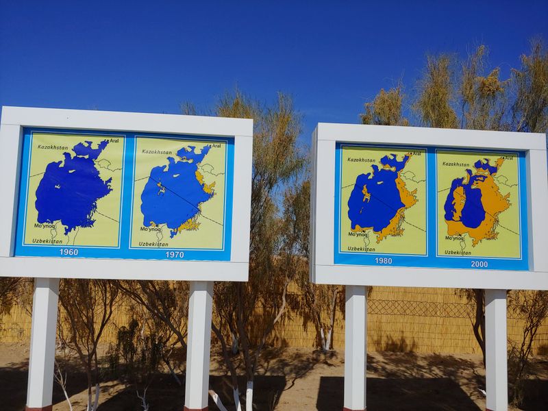
Between the 1960s and 2000s, satellite images documented one of the fastest disappearing lakes in recorded history. What began as subtle shoreline changes accelerated into a dramatic collapse.
Each year, the water level dropped noticeably, exposing more and more of the lake bed.
By the year 2000, the Aral Sea had shrunk to just one-quarter of its 1960 size. Beaches where families once swam became dusty plains stretching for miles.
Islands that had been small dots on maps grew into massive landmasses as the water retreated around them.
Scientists tracking the changes were shocked by the speed of the transformation. In some years, the shoreline receded by several kilometers annually.
Fishing villages that had been coastal communities suddenly found themselves landlocked, with the water vanishing beyond the horizon.
Aerial photographs from different decades show the progression like frames in a time-lapse video. The blue expanse steadily gives way to brown desert.
This visual evidence has made the Aral Sea a textbook example of environmental degradation, studied in schools worldwide as a cautionary tale about unsustainable resource management.
Water Volume Dropped to Just 10%
While the surface area of the Aral Sea shrank to 25% of its original size, the volume of water it contained plummeted even more dramatically. By the early 2000s, the lake held only 10% of the water it once contained.
This means that 90% of the water had simply vanished into irrigation canals or evaporated into the air.
Water volume drops faster than surface area because as a lake shrinks, it also becomes shallower. Parts of the Aral Sea that had been 50 meters deep became puddles just a few meters deep.
The loss of depth meant that even the remaining water was vulnerable to rapid evaporation under the harsh Central Asian sun.
To put this in perspective, imagine a bathtub filled to the brim, then draining it until only a thin layer covers the bottom. That’s essentially what happened to one of Earth’s largest lakes.
The remaining water became concentrated with salt and pollutants, making it increasingly hostile to life.
This catastrophic volume loss altered the regional water cycle permanently. The lake no longer provided moisture to the atmosphere, changing weather patterns across thousands of square kilometers and affecting millions of people.
Salinity Increased Fivefold
As the Aral Sea shrank, the salt that had always been present became increasingly concentrated. Originally, the lake had a salinity level similar to many healthy lakes, supporting diverse fish populations and aquatic ecosystems.
But as freshwater inflow stopped and evaporation continued, the salt had nowhere to go.
By the 1990s, salinity levels had increased fivefold, making the water saltier than most oceans. Fish species that had thrived for centuries began dying off rapidly.
The lake that had once supported 20 different commercial fish species became too toxic for almost all aquatic life.
Only the hardiest organisms, like certain types of brine shrimp, could survive in the hypersaline conditions. The food chain collapsed from the bottom up.
Birds that had migrated to the area for thousands of years found no fish to eat and stopped coming.
The rising salinity also affected the exposed lake bed. As water evaporated, it left behind thick crusts of salt that covered thousands of square kilometers.
Wind picked up this salt and scattered it across nearby farmland, poisoning soil that had once been fertile and productive.
Fragmented into Smaller Lakes
As the water level dropped, the Aral Sea didn’t just shrink uniformly. Instead, it broke apart into several separate bodies of water.
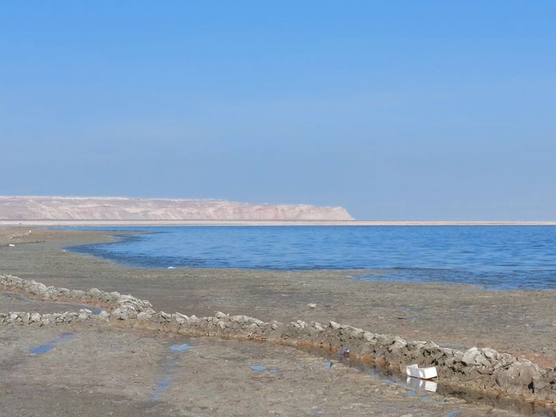
By the early 2000s, what had been a single massive lake had fragmented into the North Aral Sea, the South Aral Sea, and several smaller remnant pools.
The fragmentation happened because the lake bed wasn’t perfectly flat. As water receded, higher points in the lake bed became exposed, creating barriers between the remaining pools.
Each fragment developed its own characteristics, with some becoming saltier than others depending on whether any freshwater still reached them.
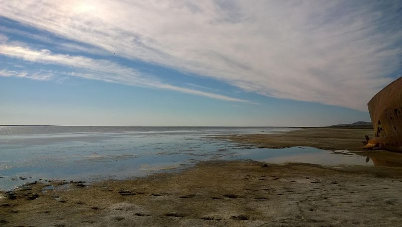
The North Aral Sea, fed by the Syr Darya River, fared slightly better than the southern portions. Kazakhstan built a dam in 2005 to preserve this section, and it has shown some recovery.
Meanwhile, the South Aral Sea, located mostly in Uzbekistan, continued shrinking and became extremely saline.
Some of the smaller fragments dried up completely within just a few years. Satellite images show these isolated pools appearing and disappearing like puddles after rain.
The fragmentation made recovery efforts more complicated, as each section now requires different management strategies to address its unique challenges.
Collapse of the Fishing Industry
For generations, fishing had been the backbone of communities surrounding the Aral Sea. Towns like Aralsk and Moynaq were home to thousands of fishermen who caught and processed tons of fish daily.
Canneries operated around the clock during peak seasons, and fish from the Aral Sea was shipped across the Soviet Union.
In the 1950s, the fishing industry employed roughly 60,000 people and produced about 40,000 tons of fish annually. Families passed down fishing knowledge and techniques through generations.
The sea provided not just employment but a cultural identity for entire communities.
As the water retreated and salinity increased, the fish populations crashed. By the 1980s, all 20 native fish species had disappeared.
The canneries closed one by one, leaving thousands unemployed. Fishermen watched helplessly as their profession became impossible.
Some families tried to adapt by transporting ocean fish to the remaining water and attempting to farm them, but the conditions were too harsh. Others abandoned their homes entirely, moving to cities in search of work.
The fishing villages that remain are now impoverished shadows of their former selves, with crumbling infrastructure and few economic opportunities for residents.
Economic Decline and Poverty
When the fishing industry collapsed, entire regional economies went down with it. Towns that had prospered for decades suddenly had no primary source of income.
Unemployment rates skyrocketed as tens of thousands of people lost their livelihoods virtually overnight.
The economic devastation extended beyond just fishermen. Workers in canneries, boat repair shops, net makers, and transportation all found themselves without jobs.
Local businesses that had served the fishing community closed their doors. Tax revenues dried up, leaving local governments unable to maintain basic services.
Health indicators in the region tell a grim story. Life expectancy in areas near the former Aral Sea dropped significantly, with some studies showing decreases of up to 15 years compared to national averages.
Poverty rates climbed as families struggled to find new sources of income in an area with few economic alternatives.
Young people who grew up in these communities often leave as soon as they’re able, seeking opportunities elsewhere. The remaining population skews older and poorer.
Many families survive on subsistence farming or small government pensions, living standards far below what their grandparents enjoyed when the fishing industry thrived.
Water Level Dropped by 16 Meters
The Aral Sea’s water level didn’t just drop gradually over time. In total, the surface of the lake fell by approximately 16 meters, equivalent to the height of a five-story building.
This dramatic vertical drop reshaped the entire geography of the region.
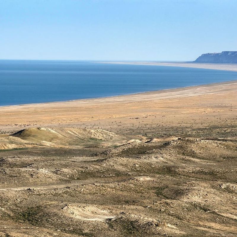
Harbors that had been built at water level ended up high and dry, their docks and piers standing uselessly in the air. Beaches gave way to cliffs as erosion carved into the newly exposed shoreline.
The lake bed, which had been underwater for millennia, suddenly became part of the terrestrial landscape.
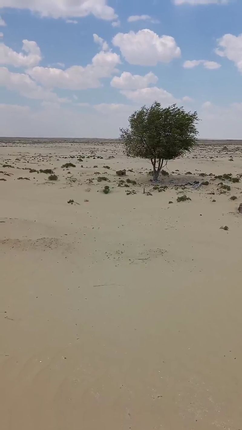
This drop exposed approximately 54,000 square kilometers of former lake bed, an area larger than the entire country of Costa Rica. The newly exposed land was flat, salty, and completely barren, supporting almost no vegetation or wildlife.
It became known as the Aralkum Desert, a completely human-made desert that didn’t exist before 1960.
The exposed sea floor created new geographic features that appear on modern maps. Former islands became hills on the desert floor.
Channels that once connected parts of the lake became dry valleys cutting through the landscape. The 16-meter drop fundamentally redrew the map of Central Asia.
Chemical Pollution from Agriculture
The irrigation water that drained the Aral Sea carried more than just H2O. Farmers growing cotton and rice used massive quantities of pesticides, herbicides, and chemical fertilizers to maximize their yields.
These toxic substances washed off the fields and flowed back into the shrinking lake.
Cotton farming, in particular, requires heavy pesticide use to protect against insects and diseases. Soviet agricultural planners pushed for maximum production without regard for environmental consequences.
Chemicals banned in many countries were used liberally across millions of hectares.
As the lake shrank, these pollutants became concentrated in the remaining water and accumulated in the exposed lake bed sediments. Studies have found dangerous levels of DDT, PCBs, and other toxic compounds.
The poisoned sediments now cover thousands of square kilometers of the former sea floor.
Wildlife that did manage to survive in the harsh conditions often showed signs of chemical poisoning. Birds that fed on the few remaining organisms accumulated toxins in their bodies.
The chemical legacy of intensive agriculture will persist in the environment for decades, making ecosystem recovery even more challenging than it would otherwise be.
Wind Spreads Salt and Chemicals
Every day, powerful winds sweep across the exposed Aral Sea bed, picking up an estimated 200,000 tons of contaminated dust, salt, and sand. These toxic clouds can travel up to 300 kilometers, affecting areas far from the former lake.
The dust storms have become a regular and dangerous feature of life in the region.
The airborne particles contain not just salt but also the agricultural chemicals that accumulated in the lake bed. When this toxic dust settles on farmland, it degrades soil quality and reduces crop yields.
Farmers hundreds of kilometers away from the Aral Sea have reported decreased productivity linked to salt contamination.
Residents describe the dust storms as choking events that force people indoors and reduce visibility to near zero. The fine particles penetrate homes, contaminate food, and coat everything with a gritty, salty residue.
Schools sometimes close during the worst storms to protect children from exposure.
The health impacts are severe. Respiratory diseases, including asthma and bronchitis, have increased dramatically in affected areas.
The salt and chemicals irritate lungs and can cause long-term damage. Some researchers believe the toxic dust contributes to high rates of cancer and other serious illnesses in communities downwind from the former sea.
Microclimate Disruption
Large bodies of water act like natural climate regulators, moderating temperature extremes and providing moisture to the atmosphere. The Aral Sea had performed this function for the surrounding region for thousands of years.
When it disappeared, the local climate changed dramatically and rapidly.
Summers in the area became significantly hotter without the cooling effect of the lake’s evaporation. Temperature records show increases of several degrees Celsius during peak summer months.
Winters grew colder as well, without the warming influence of the water’s stored heat.
Precipitation patterns shifted noticeably. The lake had contributed moisture to the atmosphere, which would fall as rain and snow in surrounding areas.
With the water gone, annual precipitation decreased by up to 30% in some locations. The growing season became shorter, making agriculture more difficult.
Humidity levels dropped, creating a drier, more desert-like environment. Plants and animals adapted to the previous climate struggled to survive.
Farmers noticed changes in when to plant and harvest crops. The microclimate disruption extended hundreds of kilometers beyond the immediate shoreline, affecting millions of people who had never directly depended on the lake but benefited from its climate-moderating effects.
Glaciers Melting 12 Times Faster
Scientists studying mountain glaciers in the Tian Shan and Pamir ranges near the Aral Sea basin have discovered an alarming acceleration in ice melt. These glaciers are now melting approximately 12 times faster than they did before the Aral Sea disaster began.
The connection between the two phenomena reveals how environmental damage can cascade through entire regions.
The Aral Sea once contributed significant moisture to the atmosphere through evaporation. This moisture would travel to nearby mountains and fall as snow, replenishing the glaciers each winter.
With the lake gone, snowfall in the mountains has decreased substantially, meaning glaciers receive less new ice to replace what melts each summer.
The microclimate changes also mean warmer temperatures reaching higher elevations. Glaciers that had remained stable for centuries now retreat visibly year by year.
The accelerated melt threatens water supplies for millions of people downstream who depend on glacier-fed rivers for drinking water and irrigation.
Ironically, the same irrigation demands that drained the Aral Sea now face a new crisis as their water sources literally melt away. The glacier melt provides a temporary increase in river flow, but once the ice is gone, those rivers will run dry during summer months, creating a future water crisis potentially worse than the current one.
A Secret Soviet Biological Weapons Lab
Vozrozhdeniya Island in the Aral Sea harbored one of the Soviet Union’s darkest secrets during the Cold War. From the 1930s through 1992, this remote location served as a testing ground for biological weapons.
Scientists experimented with some of the deadliest pathogens known to humanity, including anthrax, smallpox, plague, and tularemia.
The island’s isolation in the middle of a vast lake made it ideal for dangerous experiments. Soviet authorities believed any accidental releases would be contained by the surrounding water.
Workers at the facility conducted open-air tests of weaponized bacteria and viruses, measuring how they spread and their lethality.
When the Soviet Union collapsed, researchers hastily buried containers of anthrax spores and other materials in pits on the island. As the Aral Sea shrank, Vozrozhdeniya stopped being an island and became connected to the mainland, raising fears that people or animals might access the contaminated sites.
In 2002, American and Uzbek teams decontaminated the anthrax burial sites, but concerns remain about other pathogens.
The biological weapons legacy adds another layer of danger to the Aral Sea disaster. Beyond the environmental and economic devastation, the region now faces potential health threats from deadly diseases that were deliberately brought there and may still lurk in the soil.


