Maps promise certainty, yet the past century proved how slippery geography can be. Towns slipped underwater, coasts unraveled, and even prank places briefly became real before fading again.
As you read, you will meet communities erased by fire, war, industry, and cartographic errors that fooled generations. Keep your curiosity sharp, because each vanished dot hides a story you will want to tell.
1. Alamo Crossing, Arizona, USA
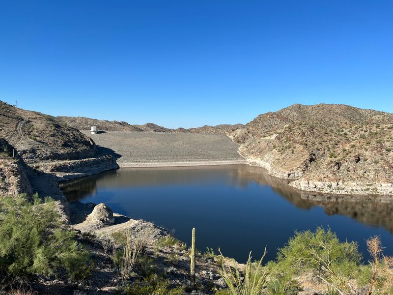
Imagine packing up a life because a river’s future will swallow your street. Alamo Crossing began as a mining camp in 1899, then slowly emptied as ore dwindled.
When the dam rose, the new Alamo Lake crept over buildings, fences, and memories.
Locals watched rooftops dip under the mirrored surface, and maps replaced roads with shoreline curves. You can fish above where porches once creaked in summer.
The town did not die loudly, it simply exhaled and sank, leaving boat wakes and sun glitter to erase its final lines.
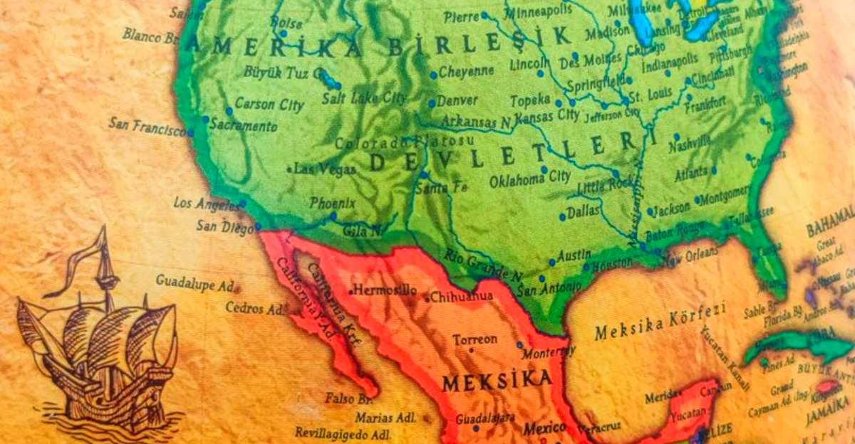
2. St. Thomas, Nevada, USA

St. Thomas thrived until Lake Mead came calling. When Hoover Dam bottled the Colorado, the reservoir crept across fields and doorsteps, forcing families to lift keepsakes and leave.
The town drowned in 1938, another casualty of progress drawn in contour lines.
Years later, drought peeled back the water and foundations reappeared like bones in sun. You can walk streets where boats once floated, hearing wind rattle through windowless frames.
Maps toggled between lake and land, but memory kept both alive. It is a place that resurfaces to remind you progress always trades something.
3. Centralia, Pennsylvania, USA
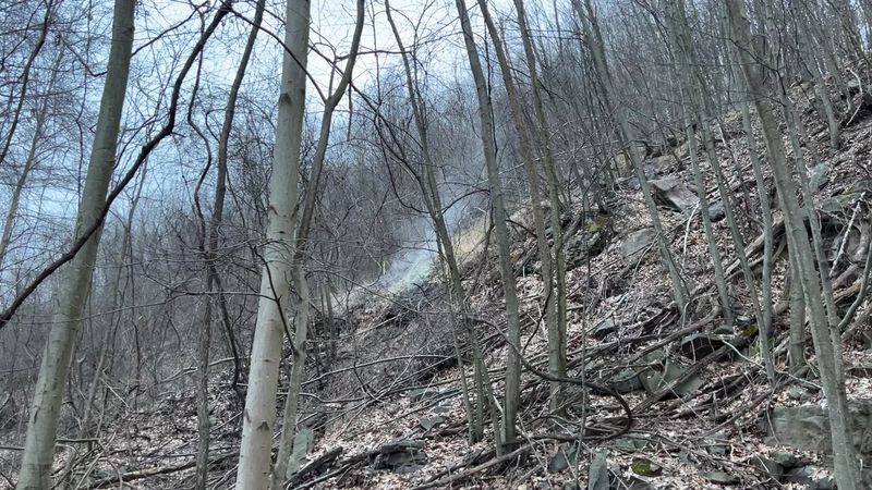
Step onto a road that breathes heat beneath your feet, and you will understand why Centralia slipped from maps. An underground coal fire ignited in 1962 turned basements into chimneys and yards into hazards.
Toxic gases, sinkholes, and relentless heat chased nearly everyone out.
Buildings vanished, lots were cleared, and addresses were revoked as officials condemned the ground. You can still see steam drifting from cracks, a reminder of danger that never sleeps.
Today the town is more cautionary tale than place, a scar teaching that resource extraction carries debts.
4. Bayocean, Oregon, USA

Bayocean began as a dream of grand resorts and seaside promenades. Investors built cottages and a natatorium, promising elegance anchored on a fragile sandspit.
Then the ocean took its tithe, storm by storm, carving breaches that unstitched streets.
By the 1960s, nearly everything had gone, houses slipping and splintering into winter swells. Locals remember dances and bright signs, now replaced by dunes and gulls.
Maps stripped labels as the town dissolved into shoreline curves. Stand there today and you will feel plans scatter like sand through fingers.
5. Keokuk, Kansas, USA
Keokuk flickered on frontier maps in the 1850s, then dimmed just as fast. As nearby towns took rail connections and trade, this settlement lost its pulse.
Families drifted away, and the prairie folded back over the place.
By the 1870s, cartographers stopped bothering with its name. You might drive past without sensing a thing, yet history once breathed here.
A handful of records, a few graves, and whispers in county archives remain. If you love the quiet, you can almost hear wagon wheels fading into the tallgrass wind.
6. Bruce, Minnesota, USA
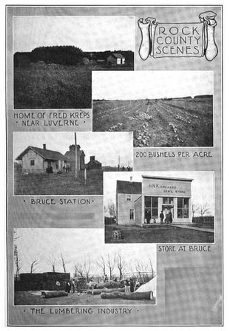
Bruce lived by the timetable of a railroad that eventually shifted away. With the line rerouted, commerce thinned, and houses followed the last departing trains.
Businesses shuttered, laughter faded, and prairie reclaimed the grid.
By the 1970s, the last buildings were removed, leaving farmland where porches once watched locomotives. You could pass the site and never know a depot stood here.
On old maps, a dot marks hope; on new ones, only fields. The story feels familiar across the Midwest, where rails once stitched communities that later unraveled.
7. Port Perry, Pennsylvania, USA
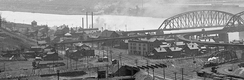
Port Perry began as a riverside town, then industry arrived with bigger plans. Tracks multiplied, bridges sprouted, and the land where homes stood turned into steel arteries.
By 1945, the town had been absorbed, a neighborhood traded for throughput.
Maps replaced streets with switchyards and sidings, prioritizing cargo over porches. You can trace its outline only by reading the rails, each line a sentence in a longer Pittsburgh story.
Progress made the place essential and invisible at once. It vanished without moving, swallowed by the machines it helped feed.
8. Tracy, Illinois, USA

Tracy boomed on coal, then waned when the seam ran dry. Houses emptied, stores closed, and the night shift clock fell silent.
A place that once glowed with miner lamps dimmed to prairie twilight by 1900.
You can still feel the rhythm of shift change if you listen to the wind through weeds. The mapmakers felt nothing and erased the name.
Resource towns live brisk, risky lives, and Tracy’s was brief. It is a lesson about betting futures on seams that end, leaving only stories and subsidence behind.
9. Tyneham, Dorset, England
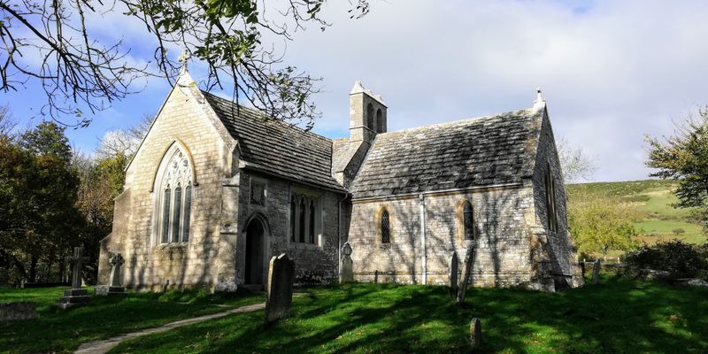
In 1943, residents of Tyneham left door keys with notes promising to return. The military needed the valley for training, and war urgency trumped village continuity.
After victory, repopulation never came, and the civil parish faded into administrative history.
Walking there, you read letters in the church and feel the ache of interrupted lives. The village stands as a careful ruin, open on certain days, but no longer truly a place to live.
Maps now nod politely, then look away. You will leave whispering thanks and questions.
10. Agloe, New York, USA (map phantom)
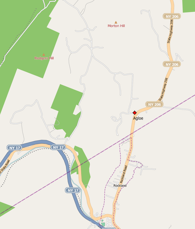
Agloe began as a cartographer’s trap, a made up town to catch copyists. Then a general store adopted the name, turning fiction into a brief reality with receipts and directions.
Drivers asked for Agloe and found it, which made maps blush.
When the store closed and usage dimmed, the place slipped back toward legend. Modern maps shrugged and deleted it, though fans still hunt the junction.
You can stand there and feel how belief sketches geography. Sometimes, if enough people agree, a name becomes a town until silence wins.
11. Goblu and Beatosu, Michigan, USA (phantom places)
Cartographers have jokes, and Michigan once carried two of them. Goblu and Beatosu appeared in a 1978 map, winks toward college football chants.
Travelers never found them, of course, but the names delighted readers who noticed.
As accuracy tightened and digital checks took over, the phantom towns vanished. You will not see them in modern GPS, just a cleaner slate.
Still, the prank lingers in lore, proving maps reflect culture as much as terrain. If you ever get lost, at least you can blame a punchline.
12. Sandy Island, Coral Sea (phantom island)

For generations, charts marked a neat rectangle labeled Sandy Island northwest of New Caledonia. Sailors plotted around it, satellites inherited it, and databases nodded along.
In 2012, researchers sailed straight through the supposed spot and met nothing but blue water.
Mapmakers quietly deleted the island, and headlines chuckled at a cartographic ghost. You can still find old atlases that swear it exists.
The moment reminds you that even modern knowledge carries hand me downs. Sometimes, the ocean is the only editor that matters.
13. Hy-Brasil (phantom island)
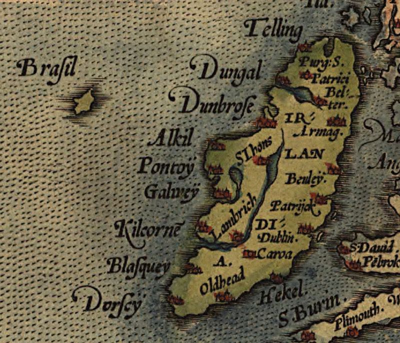
Hy-Brasil haunted charts for centuries, a round island promised to appear every seventh year. Sailors told stories, scholars echoed them, and mapmakers inked hope into the Atlantic.
Expeditions returned with waves and fog instead of land.
Eventually, the name slipped into legend while the coordinates stayed lonely. You will feel its pull if you love mysteries more than certainties.
Modern maps prefer evidence, so Hy-Brasil bowed out. Still, when mist hugs the horizon off Ireland, a part of you might believe again.
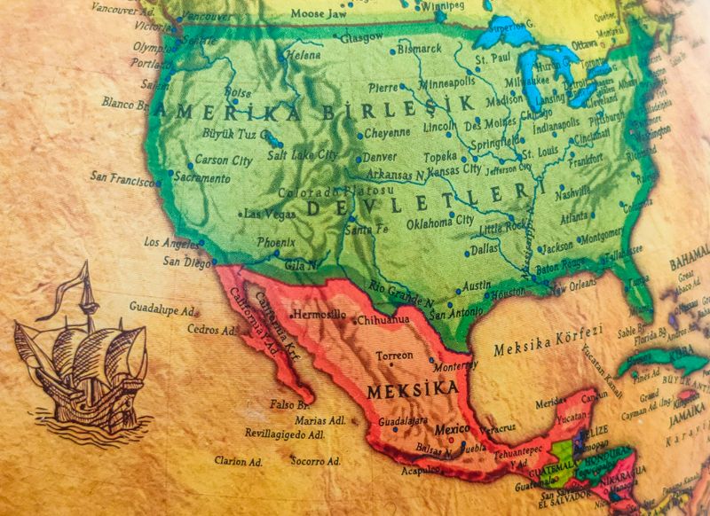
14. Bermeja Island (phantom island)
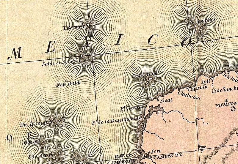
Bermeja hovered on maps off the Yucatán for centuries, influencing legal boundaries and oil dreams. Surveys kept coming up empty, yet the cartographic inertia held.
When modern scans found only deep water, negotiations had to adjust to absence.
You can sense how a pencil mark can reshape real world stakes. Erasing Bermeja did not just tidy a chart, it shifted maritime math.
Today, it survives mostly as a question: mistake, erosion, or myth. Either way, the Gulf kept its secret, and the maps finally surrendered.
15. Lost river towns around the world
Dams promised lights and irrigation, but many valleys paid the price. From Spain to China to the Americas, rivers backed up and villages slipped under rising surfaces.
Bells that once called markets now toll only when drought lowers the water.
You can boat over tiled floors and peer into schoolrooms through green shadows. Maps replaced names with blue, tidy shapes hinting at submerged grids.
Progress made lakes you picnic beside, while histories sleep below you. The tradeoff is visible on every shoreline where steps lead nowhere.
16. Ghost villages across Europe

Across Europe, empty villages tell stories of war, migration, and slow decline. Some were shelled and evacuated, others starved of opportunity until the last door closed.
Grass grows through thresholds where gossip once bloomed.
Walk gently and you will hear echoes between cracked plaster and birdsong. Regional maps trimmed these names, consolidating parishes and erasing scattered dots.
Yet the stones remember handprints and hearth smoke. If you love ruins, you will find beauty and grief sharing the same key.


