Europe might be famous for its historic cities and ancient monuments, but its wild side tells an entirely different story. From thundering waterfalls to ancient forests that have stood for thousands of years, the continent holds some of the most breathtaking natural landscapes on Earth.
Whether you’re drawn to dramatic coastlines, towering mountain peaks, or mysterious volcanic beaches, these natural wonders showcase nature at its most powerful and beautiful.
Plitvice Lakes National Park — Croatia
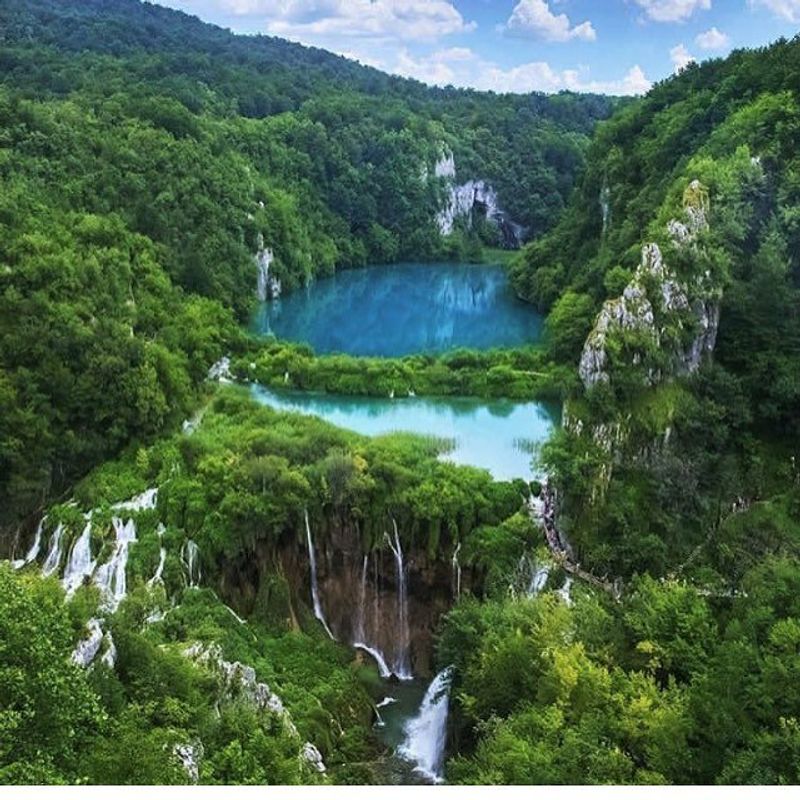
Water flows like liquid turquoise through this Croatian wonderland, creating one of nature’s most mesmerizing displays. Sixteen terraced lakes connect through countless waterfalls, each one spilling into crystal-clear pools below.
Wooden walkways wind through the park, letting visitors walk just inches above the water’s surface. The minerals in the water create those stunning blue-green colors that look almost unreal in photographs.
Fish dart beneath your feet as you cross the bridges, completely visible in the transparent depths.
Every season transforms the park into something new. Spring brings rushing water from melting snow, summer offers perfect swimming temperatures, autumn paints the forests in gold and red, and winter occasionally freezes the waterfalls into giant icicles.
The park covers nearly 300 square kilometers of protected wilderness, home to bears, wolves, and rare bird species that thrive in this untouched environment.
The Dolomites — Italy
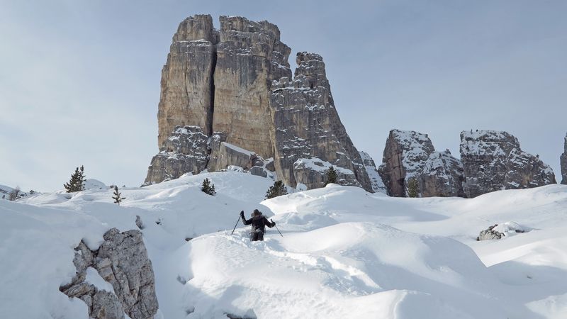
Jagged limestone towers shoot straight up from green valleys, creating a mountain range unlike any other in Europe. The Dolomites earned their UNESCO World Heritage status for good reason—these peaks look like something from another planet.
Climbers from around the world come here to tackle the vertical rock faces. The stone itself is special, formed from ancient coral reefs that existed when this area was covered by a tropical sea millions of years ago.
At sunrise and sunset, the mountains glow pink and orange in a phenomenon locals call “enrosadira.”
Summer meadows burst with wildflowers while mountain goats navigate impossible ledges. Winter blankets everything in snow, turning the region into a skiing paradise.
Historic mountain refuges dot the landscape, offering warm meals and beds to hikers tackling the famous Alta Via trails that wind through these spectacular peaks.
Cliffs of Moher — Ireland
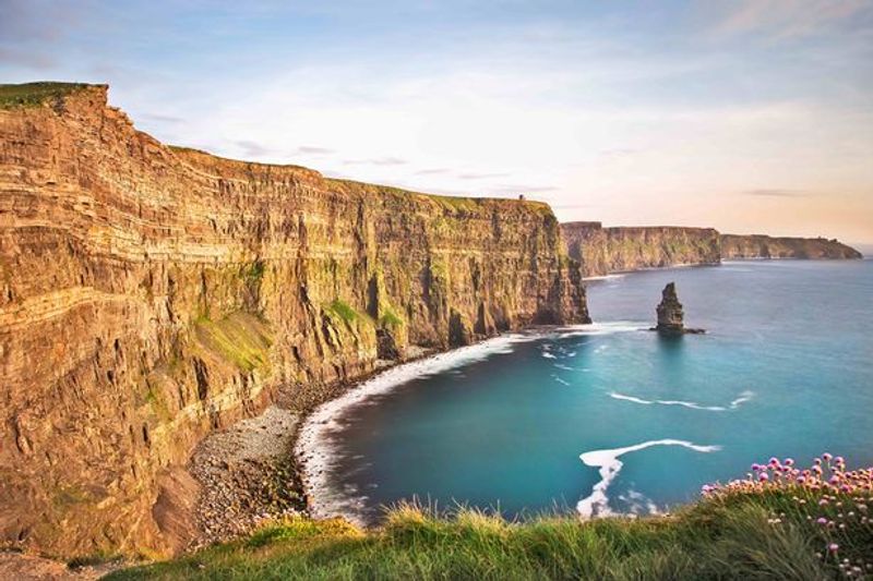
Standing at the edge feels like reaching the end of the world, with nothing between you and America except endless ocean. These massive cliffs rise over 700 feet straight up from the pounding Atlantic waves below.
Wind whips constantly across the clifftops, carrying the cries of thousands of seabirds. Puffins nest in the rock crevices during breeding season, their colorful beaks making them easy to spot.
The cliffs stretch for five miles along the coast, each viewpoint offering a different perspective of this raw, powerful landscape.
O’Brien’s Tower stands at the highest point, built in 1835 as an observation spot for Victorian tourists. On clear days, you can see the Aran Islands floating in the distance and the Twelve Bens mountain range to the north.
The visitor center is actually built into the hillside to protect the natural scenery, with grass growing on its roof.
Jasmund National Park (Chalk Cliffs) — Germany
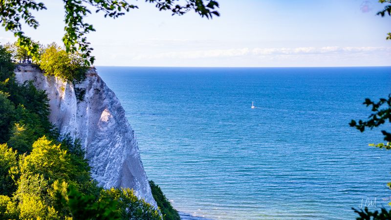
Brilliant white cliffs plunge into the turquoise Baltic Sea, creating Germany’s most striking coastal landscape. The chalk formations tower up to 390 feet high, their pale faces contrasting sharply with the dark green beech forests crowning their tops.
Artist Caspar David Friedrich made these cliffs famous with his romantic paintings in the early 1800s. The Königsstuhl, or King’s Chair, marks the highest and most photographed point along the cliff edge.
Ancient beech forests behind the cliffs earned their own UNESCO designation, protecting trees that have grown here for centuries.
Fossils hide within the chalk layers, remnants of tiny sea creatures from 70 million years ago. Erosion constantly reshapes the cliffs, occasionally causing dramatic collapses that send huge chunks tumbling into the sea below.
Amber hunters search the beaches after storms, hoping to find precious pieces of fossilized tree resin washed up by the waves.
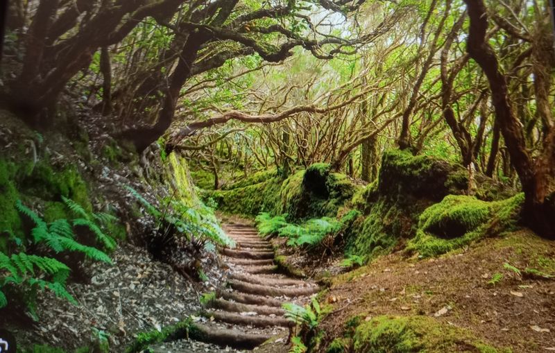
Białowieża Forest — Poland/Belarus
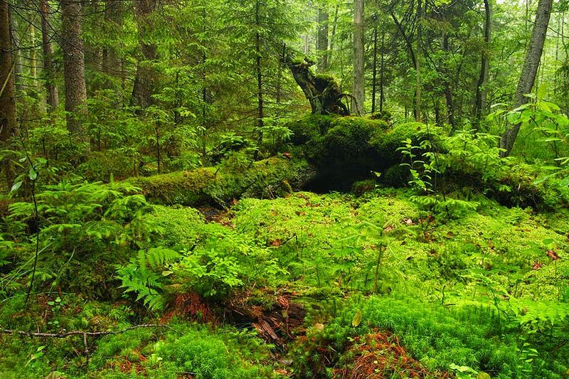
Trees older than most European cities still stand in this primeval forest, the last fragment of wilderness that once covered the entire continent. Some oaks here were already ancient when Columbus sailed to America.
European bison, the continent’s largest land animal, roam freely through the undergrowth. These massive creatures nearly went extinct but now thrive under protection in this forest sanctuary.
Wolves, lynx, and wild boar also call this place home, living much as their ancestors did thousands of years ago.
Walking through Białowieża feels like stepping back in time. Dead trees lie where they fall, slowly decomposing and feeding new growth in the natural cycle that humans haven’t interrupted here.
The forest straddles the Poland-Belarus border, with the Polish side more accessible to visitors. Guided tours take you deep into the strictly protected core zone, where even the paths disappear into true wilderness.
Skaftafell & Vatnajökull Region — Iceland
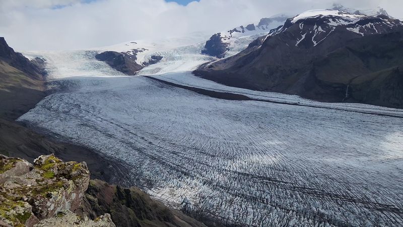
Europe’s largest ice cap dominates this corner of Iceland, covering an area bigger than all the other glaciers in Europe combined. Vatnajökull sprawls across eight percent of Iceland’s total landmass, its ice reaching depths of 3,000 feet in places.
Glacier tongues flow down from the main ice cap like frozen rivers. Skaftafell serves as the gateway to this icy wilderness, offering trails that lead to stunning viewpoints and glacier edges.
The contrast between black volcanic sand and brilliant white ice creates surreal landscapes that photographers dream about.
Volcanoes hide beneath the ice, occasionally erupting and causing massive floods when they melt through the glacier. Ice caves form in winter, their walls glowing electric blue from compressed ancient ice.
Climate change is shrinking these glaciers rapidly, making them even more precious to witness. Guided glacier walks let visitors strap on crampons and explore this frozen world safely.
Reynisfjara Black Sand Beach — Iceland
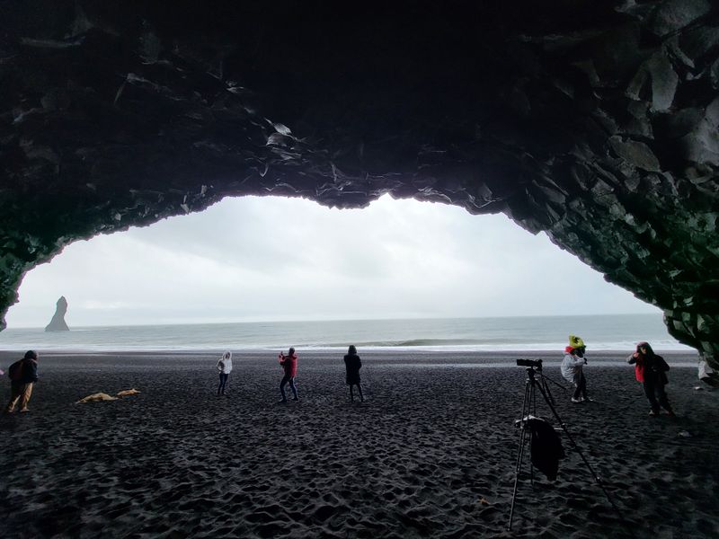
Volcanic black sand stretches along this wild Atlantic beach, where hexagonal basalt columns rise like a natural cathedral. The sand itself comes from lava that cooled so quickly in ocean water that it shattered into fine black particles.
Reynisdrangar sea stacks stand offshore, their pointed shapes rising dramatically from the churning waves. Local legends claim these are trolls who were caught by sunrise and turned to stone.
The basalt columns forming the cave walls look almost too geometric to be natural, their perfect hexagons fitting together like a giant’s honeycomb.
This beach is beautiful but dangerous—sneaker waves can sweep across the sand without warning, pulling unwary visitors into the freezing Atlantic. Warning signs remind everyone to never turn their back on the ocean here.
Puffins nest on nearby cliffs during summer months. The combination of black sand, white foam, and dramatic rock formations makes this one of Iceland’s most photographed locations.
Isle of Skye & Old Man of Storr — Scotland
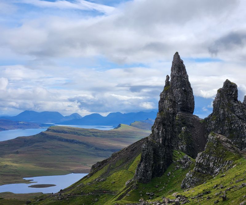
A massive rock pinnacle juts from the hillside like a giant’s finger pointing at the sky. The Old Man of Storr stands 165 feet tall, part of a landslide that created one of Scotland’s most iconic landmarks centuries ago.
Mist often wraps around the rocky spires, adding to the mysterious atmosphere that makes Skye feel almost magical. The hike up to the Old Man takes about an hour, winding through rocky terrain that gets steeper as you climb.
Sheep graze on impossibly steep slopes, seemingly unconcerned by the dramatic drops.
Skye’s landscape formed from ancient volcanic activity, creating the rugged peaks and strange rock formations that define the island. Fairy pools, hidden waterfalls, and dramatic sea cliffs await around every corner.
Weather changes constantly here—sunshine, rain, wind, and fog can all happen in a single afternoon. The island’s remote location keeps light pollution low, making it perfect for stargazing on clear nights.
Tara River Canyon — Montenegro
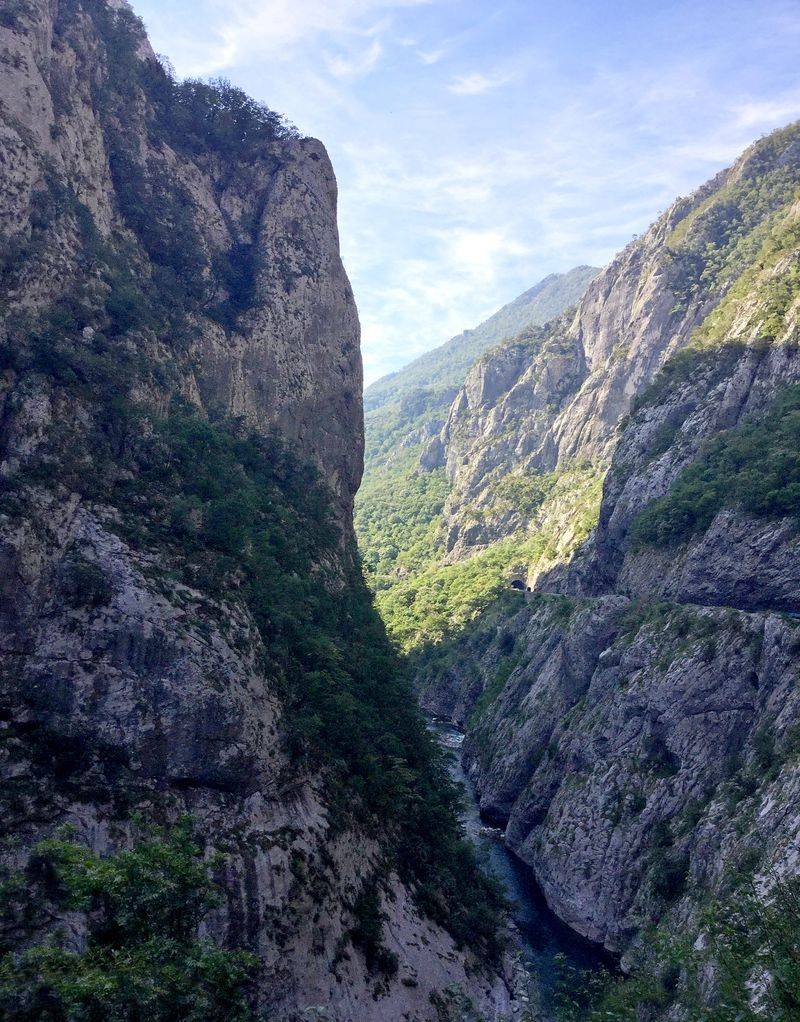
Europe’s deepest canyon slices through Montenegro’s mountains, reaching depths of 4,300 feet in places. Only the Grand Canyon in America goes deeper, making Tara a truly exceptional natural wonder.
The Tara River runs emerald green at the canyon bottom, fed by mountain springs and snowmelt. Rafting this river ranks among Europe’s best whitewater adventures, with rapids ranging from gentle floats to heart-pounding class IV sections.
Dense forests blanket the canyon walls, protecting some of Europe’s last old-growth forests.
A dramatic concrete bridge spans the canyon at its narrowest point, offering dizzying views straight down to the river. During World War II, a local engineer destroyed part of this bridge to slow advancing troops, then rebuilt it after the war.
The canyon forms part of Durmitor National Park, a UNESCO site protecting pristine wilderness. Black pines growing here can live over 400 years, their twisted trunks shaped by harsh mountain winds.
Lake Bohinj & Triglav National Park — Slovenia
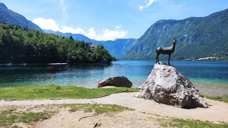
Crystal-clear water mirrors the surrounding Julian Alps in this glacial lake that remains remarkably peaceful despite its stunning beauty. Lake Bohinj sits within Slovenia’s only national park, protected from the overdevelopment that has changed other alpine destinations.
Mount Triglav rises in the distance, Slovenia’s highest peak and a national symbol that even appears on the country’s flag. The lake formed when glaciers carved out this valley during the last ice age, leaving behind a natural basin that filled with meltwater.
Swimming here feels refreshing even in summer—the water stays cool from underground springs.
Traditional alpine villages dot the lakeshore, their wooden architecture blending naturally with the landscape. Cable cars whisk visitors up to mountain viewpoints, while hiking trails lead to waterfalls and alpine meadows.
Winter transforms the area into a quieter wonderland, with far fewer tourists and opportunities for cross-country skiing. The Savica Waterfall nearby plunges 78 meters in a dramatic double cascade.
Ring of Kerry Coastline — Ireland
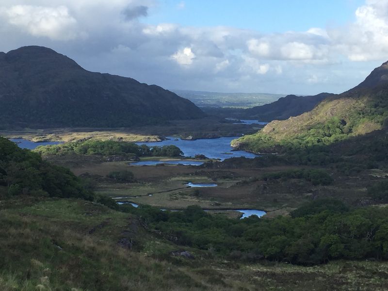
Winding roads hug the coastline for 111 miles around the Iveragh Peninsula, revealing new spectacular views around every curve. Mountains rise on one side while the wild Atlantic pounds the rocky shore on the other.
Ancient stone walls divide impossibly green fields where sheep graze on hillsides so steep it seems they might tumble into the sea. The Skellig Islands rise dramatically offshore, their rocky peaks home to an ancient monastery that monks somehow built 1,400 years ago.
Purple heather blankets the mountains in late summer, adding splashes of color to the already vibrant landscape.
Small villages along the route offer traditional Irish pubs where locals still speak Gaelic. The drive takes most of a day if you stop to explore properly—rushing through would mean missing hidden beaches, waterfall hikes, and viewpoints that take your breath away.
Tour buses travel clockwise, so driving counterclockwise gives you better passing opportunities on the narrow roads.
Anaga Rural Park — Tenerife, Spain
Prehistoric laurel forests blanket volcanic ridges in this corner of Tenerife, creating landscapes that look nothing like typical Spanish scenery. These ancient forests survived here while disappearing from mainland Europe millions of years ago.
Mist rolls through the mountains almost daily, keeping the forests lush and green year-round. The twisted laurel trees grow dense with moss and lichen, their branches creating a green canopy that filters sunlight into an emerald glow.
Hiking trails wind through this primeval landscape, sometimes emerging onto ridgelines with dramatic views down to the Atlantic.
Tiny villages cling to mountainsides, connected by roads so narrow and winding that rental car companies sometimes restrict access. The volcanic soil produces excellent sweet potatoes and other crops that locals still farm using traditional methods.
Anaga’s isolation helped preserve both its natural environment and traditional culture. The park protects over 140 endemic plant species found nowhere else on Earth, making it a living museum of evolution.
Retezat National Park — Romania
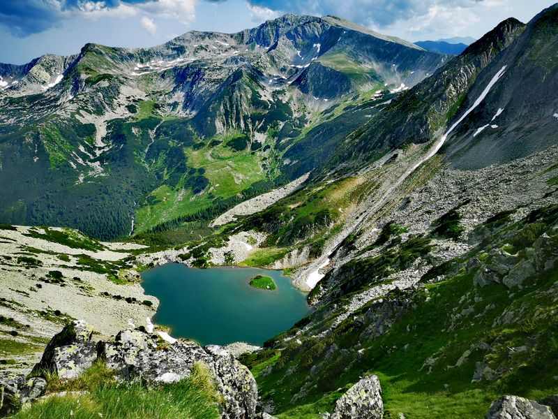
Over 80 glacial lakes sparkle among Romania’s wildest mountains, each one a different shade of blue or green depending on depth and mineral content. Retezat became Romania’s first national park in 1935, protecting these pristine Carpathian landscapes.
Chamois leap across rocky slopes with impossible grace while brown bears roam the forests below. The park shelters over a third of all plant species found in Romania, with alpine meadows exploding in wildflowers each summer.
Some valleys remain so remote that wolves and lynx hunt undisturbed by human presence.
The highest peaks top 8,000 feet, high enough for true alpine conditions above the treeline. Glaciers carved these mountains during ice ages, leaving behind the distinctive U-shaped valleys and hanging valleys visible today.
Multi-day hiking routes connect mountain refuges, allowing backpackers to explore deep into the wilderness. Lake Bucura, the largest glacial lake, sits at 6,800 feet elevation, its cold waters home to trout that thrive in the pristine conditions.
Saxon Switzerland National Park — Germany
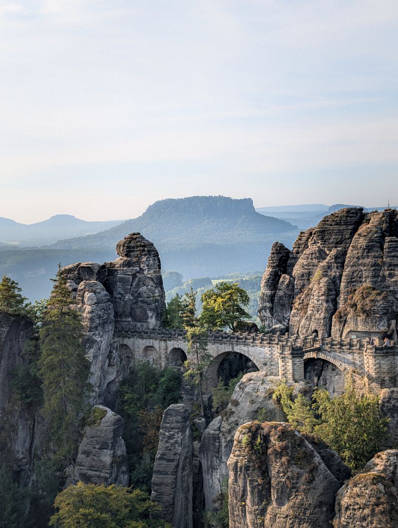
Sandstone towers rise like natural skyscrapers from forested valleys, creating rock formations so dramatic that 18th-century Swiss artists named the region after their homeland. The Elbe River carved these shapes over millions of years, cutting through soft sandstone layers.
The Bastei Bridge connects rock pinnacles 630 feet above the river, offering views that seem impossible from such a small country. Rock climbers tackle the sandstone towers using special rules that protect the soft stone—no metal equipment allowed, just knotted slings wedged into cracks.
Over 1,100 peaks offer climbing routes ranging from beginner-friendly to expert-only.
Forests of beech and pine soften the dramatic rock landscape, their roots somehow finding purchase in the minimal soil. The park straddles the German-Czech border, with even more spectacular formations continuing into Bohemian Switzerland on the Czech side.
Early morning mist often fills the valleys, leaving the rock towers floating above a sea of clouds like islands in the sky.
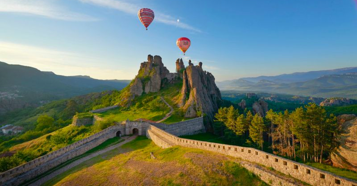
Belogradchik Rocks — Bulgaria
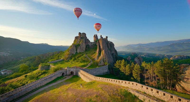
Massive red sandstone pillars rise up to 650 feet high, their bizarre shapes inspiring names like The Horseman, The Bear, and The Mushrooms. Wind and water sculpted these formations over 230 million years, creating Bulgaria’s most surreal landscape.
A fortress built directly into the rocks has stood here for over 2,000 years, its walls blending seamlessly with the natural stone towers. Romans started the fortifications, with later civilizations adding to the defenses.
Climbing to the fortress offers panoramic views across the rock formations and surrounding countryside.
The rocks glow brilliant orange-red during sunrise and sunset, their iron-rich sandstone catching the light. Locals have assigned legends to nearly every formation—one rock supposedly turns anyone who looks at it to stone, while another grants wishes if you walk around it three times.
The area remains relatively undiscovered by mass tourism, meaning you might have these incredible formations almost to yourself, especially outside summer months.


