Ireland is the kind of country that makes you stop mid-sentence and just stare. From ancient stone towers rising out of morning mist to cliffs that plunge hundreds of feet into a roaring Atlantic, this island has a way of making the real world feel like a fairy tale.
Whether you’re a history buff, a nature lover, or just someone who enjoys a good jaw-dropping view, Ireland has something that will leave you speechless. Get ready to explore 15 places so breathtaking, you’ll have to remind yourself they actually exist.
Connemara — Wild Western Beauty
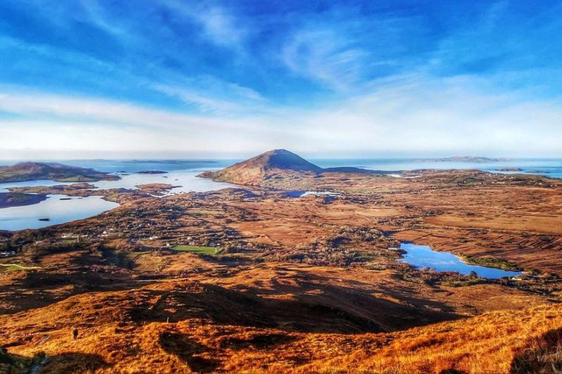
There’s a particular kind of silence in Connemara that feels ancient, like the land is holding its breath. Stretching across County Galway’s wild western edge, this region is a patchwork of shimmering bogs, glassy lakes, and jagged mountain peaks that seem to shift color with every passing cloud.
It’s the kind of scenery that inspired countless Irish poems and paintings.
Diamond Hill offers some of the best hiking in the country, rewarding climbers with sweeping views over the Atlantic coastline. Not far away, Kylemore Abbey sits tucked against a hillside beside a lake, looking like it was designed by someone who wanted to make photographers cry happy tears.
The contrast between the wild bogland and the abbey’s gothic elegance is genuinely unforgettable.
Connemara is also one of the strongest Irish-speaking regions in Ireland, known as part of the Gaeltacht. Locals here have preserved the language and traditions for generations, giving the region a cultural depth that goes far beyond its stunning looks.
Come for the scenery, stay for the soul of old Ireland.
Skellig Michael — Island Monastery Perched on the Sea
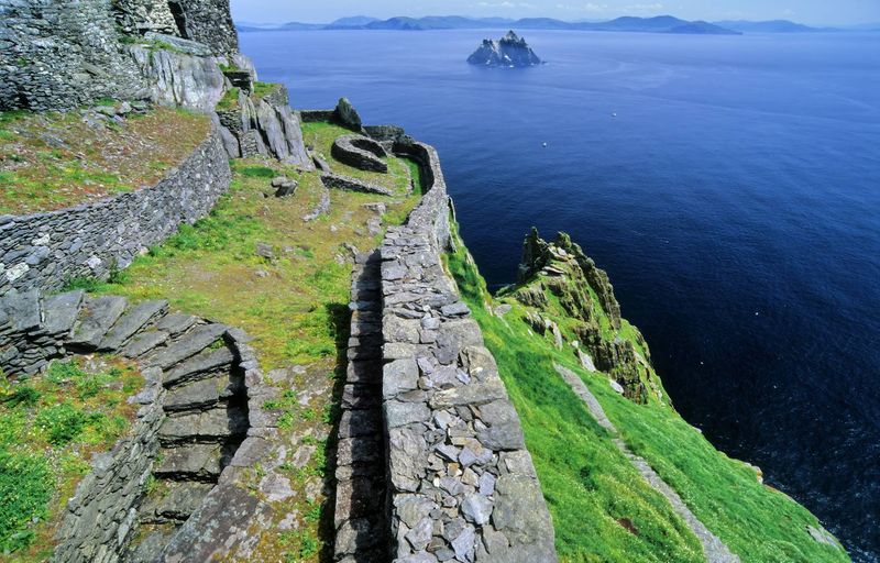
Jutting out of the Atlantic like a jagged tooth, Skellig Michael looks less like a real place and more like a location a fantasy novelist invented on a very good day. This UNESCO World Heritage Site sits about eight miles off the coast of County Kerry, rising nearly 700 feet out of the sea.
Getting there involves a boat ride that will test your sea legs.
Monks built a monastery on its near-vertical cliffs back in the 6th century, constructing stone beehive huts that have survived more than 1,400 years of Atlantic storms. The nearly 600 steps carved into the rock face lead visitors up to this remarkable settlement, offering views that feel genuinely cosmic.
Star Wars fans will recognize it as Luke Skywalker’s island hideout from The Last Jedi.
Access is limited to protect the fragile ecosystem and ruins, so booking well in advance is essential. Only licensed boats are permitted to land, and trips are weather-dependent.
The island is also home to thousands of puffins during summer, adding a surprisingly adorable element to one of Ireland’s most dramatic destinations.
Ring of Kerry — Epic Coastal Loop

Pull over every five minutes — that’s basically the unofficial rule for driving the Ring of Kerry. This 111-mile circular route through County Kerry delivers a non-stop parade of dramatic coastline, heather-covered mountains, and glacial lakes that shimmer in the Irish light.
Every single bend in the road feels like a postcard waiting to be taken.
The route passes through charming towns like Kenmare and Killarney, where you can grab a warm bowl of chowder before heading back out into the wild landscape. Sheep have an unofficial right of way on many roads here, so patience is part of the experience.
The village of Sneem, painted in bright colors along the river, is a highlight that often gets overlooked by drivers rushing the loop.
Cycling the Ring of Kerry is a popular challenge, with an annual charity event drawing thousands of participants each summer. Drivers are actually advised to travel counterclockwise to avoid tour buses on the narrow mountain roads — a practical tip that can save a lot of stress.
The Ring of Kerry rewards slow travelers most generously, so take your time and soak in every mile.
Dingle Peninsula & Slea Head Drive — Edge of Europe Views
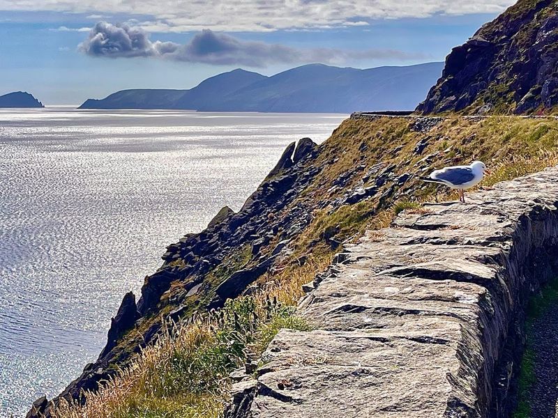
Slea Head Drive has earned a reputation as one of the most scenic coastal roads in all of Europe, and one look explains exactly why. Hugging the edge of the Dingle Peninsula in County Kerry, this route unspools past sheer cliffs, wild sandy beaches, and ancient stone structures that have stood for over a thousand years.
The Blasket Islands float in the Atlantic just offshore, adding a hauntingly beautiful backdrop to every view.
Fungie the dolphin became a beloved local celebrity in Dingle town for decades, greeting boats in the harbor until his mysterious disappearance in 2020. The town itself is a lively mix of colorful pubs, excellent seafood restaurants, and a genuine Irish-speaking community that keeps the Gaeltacht tradition alive.
Walking any stretch of the peninsula puts you in landscapes that feel older than memory.
The Gallarus Oratory, a perfectly preserved dry-stone church built around the 8th century, sits just off the main drive and is worth every detour minute. It has no mortar holding it together — just perfectly fitted stone.
That kind of craftsmanship still baffles engineers today, making this stretch of coastline as intellectually fascinating as it is visually stunning.
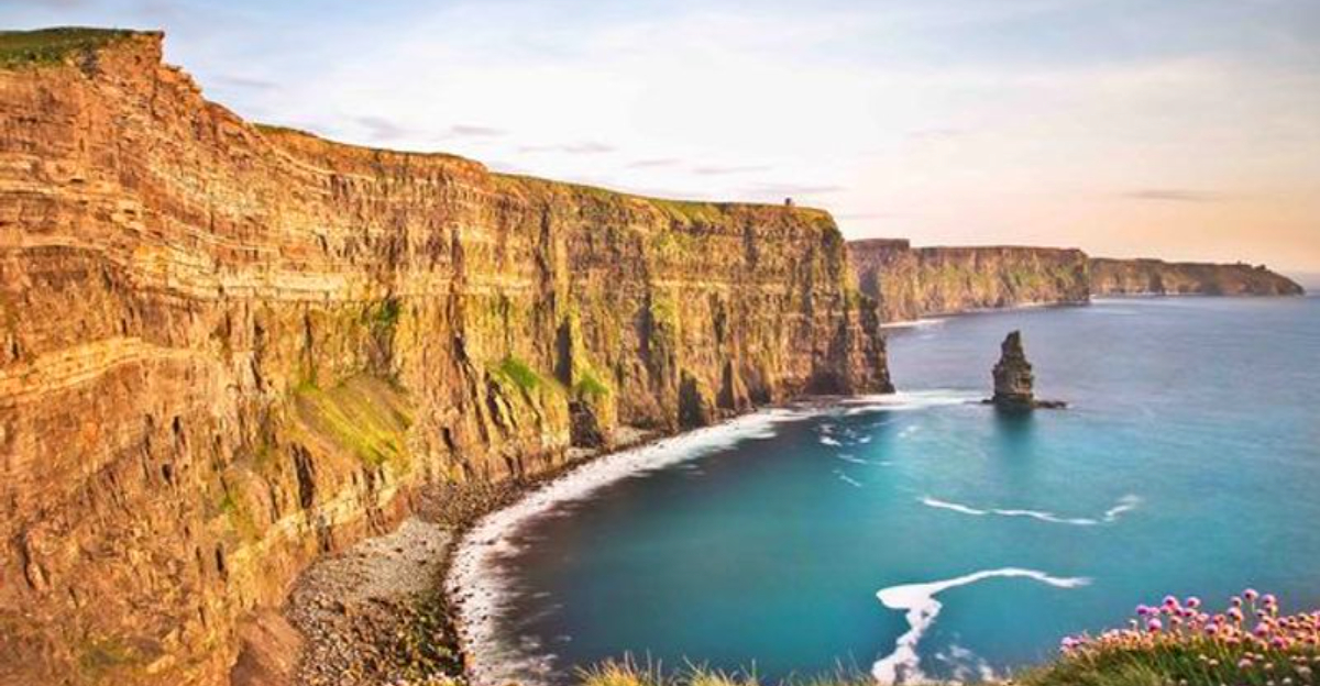
Cliffs of Moher — County Clare
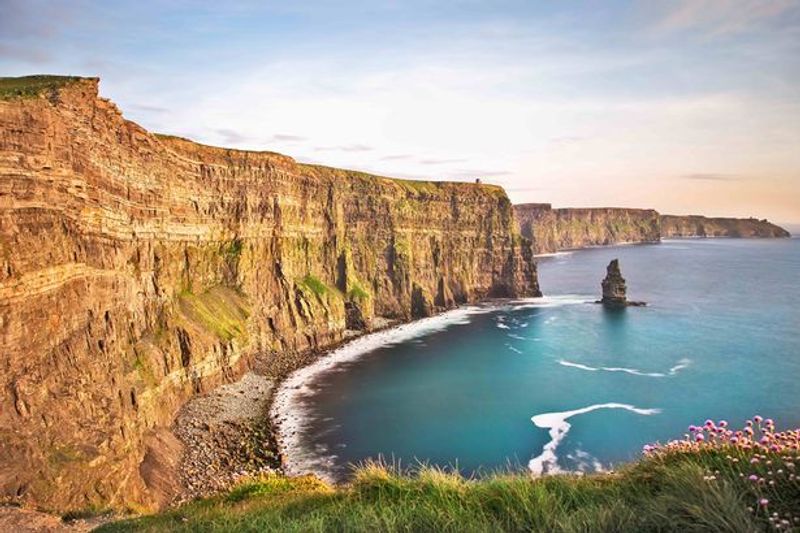
Stand at the edge of the Cliffs of Moher and your brain genuinely struggles to process what it’s seeing. These cliffs rise more than 700 feet above the Atlantic Ocean, stretching nearly five miles along the coast of County Clare.
The scale alone is enough to make your knees wobble a little.
Sea birds like puffins and razorbills nest in the rocky faces, swooping and calling above the thundering waves below. On clear days, you can spot the Aran Islands floating in the distance like something out of a storybook.
When fog rolls in, the whole scene turns moody and dramatic in the best possible way.
Over one million visitors show up here every year, and honestly, every single one of them earns the trip. The visitor center is built into the hillside to keep the landscape unspoiled.
Wear sturdy shoes, hold onto your hat, and prepare to have your breath stolen — not just by the wind, but by one of the most spectacular natural views on the planet.
Glendalough — 1,000-Year-Old Valley of Lakes and Monastic Ruins
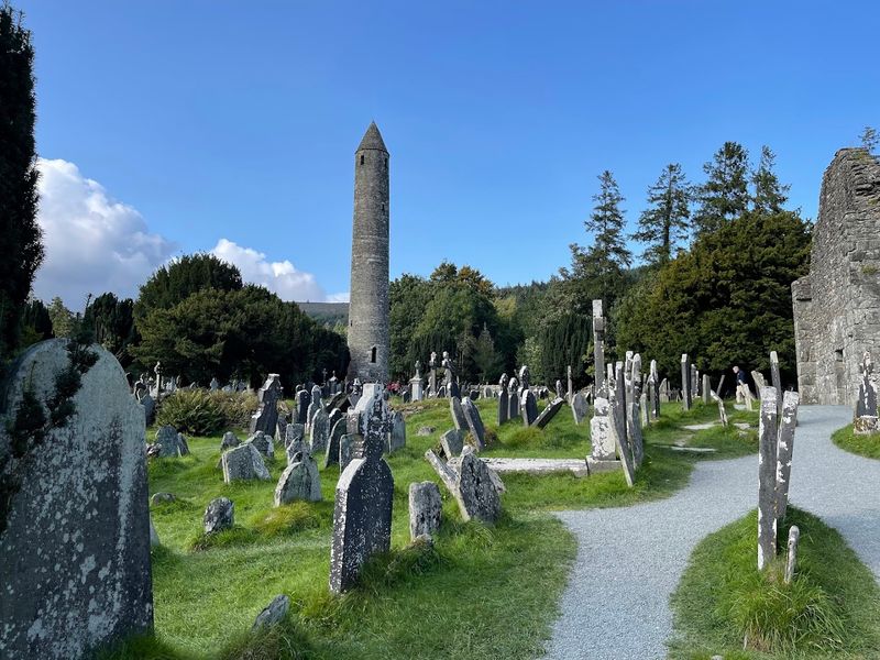
Mist clings to the treetops at Glendalough like it belongs there, and honestly, it probably does. Tucked into the Wicklow Mountains just an hour south of Dublin, this glacial valley hides one of Ireland’s most hauntingly beautiful monastic settlements, founded by St. Kevin in the 6th century.
The name itself means “Valley of the Two Lakes,” and the views across those dark, still waters are exactly as magical as that sounds.
The round tower standing at the center of the ruins is nearly 100 feet tall and over 1,000 years old, yet it looks like it was built to last forever. Surrounding it are crumbling stone churches, Celtic high crosses, and ancient graveyards that stretch back into the medieval period.
Walking through the site feels like stepping through a portal into a quieter, older world.
Glendalough is also a superb hiking destination, with trails ranging from easy lakeside strolls to more challenging routes up the surrounding peaks. The Upper Lake trail offers some of the most rewarding views in County Wicklow.
Go early in the morning to beat the crowds and catch the mist at its most atmospheric — you won’t regret the early alarm.
Newgrange — Ancient Passage Tombs Older Than the Pyramids
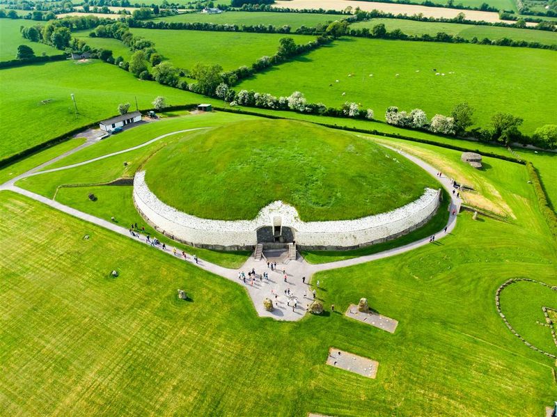
Newgrange was already ancient when the Egyptians started building the pyramids — let that sink in for a moment. This massive passage tomb in County Meath was constructed around 3,200 BC, making it over 5,000 years old and one of the oldest surviving buildings on Earth.
The people who built it had no metal tools, no wheels, and no GPS, yet they pulled it off with breathtaking precision.
Every year on the winter solstice, a narrow beam of sunlight enters the tomb through a specially aligned roof box and slowly illuminates the inner chamber for about 17 minutes. The alignment is so exact that it only works on the solstice and a few days around it.
A lottery system determines who gets to witness this event in person, and the waiting list stretches years long.
The exterior is decorated with stunning spiral carvings that nobody has fully decoded, adding a layer of mystery that keeps archaeologists busy. The surrounding landscape is part of the Bru na Boinne World Heritage Site, which includes two other passage tombs, Knowth and Dowth.
A visit here is less like a tourist trip and more like a conversation with the deep, unwritten past.
Aran Islands — Windows to Old Ireland
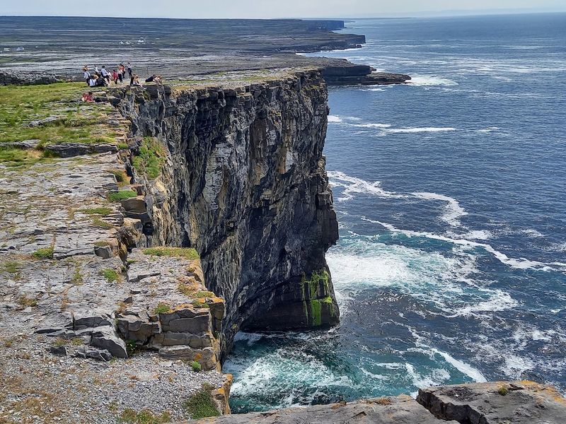
Stepping off the ferry onto Inishmore feels like arriving somewhere time forgot to update. The largest of the three Aran Islands sits in Galway Bay, carved up by thousands of miles of dry stone walls that divide the landscape into a patchwork of tiny fields.
These walls were built by hand over centuries, using stones cleared from the thin soil to make farming possible.
Dun Aengus is the crown jewel of the islands — a prehistoric stone fort perched right on the edge of a 300-foot cliff with absolutely no safety railing. Visitors crawl to the edge on their hands and knees to peer down at the crashing Atlantic below, which is terrifying and completely worth it.
Archaeologists still debate its exact purpose, which only makes it more compelling.
Irish is the primary language spoken here, and the islands have long been a center of traditional music, storytelling, and craft. Renting a bicycle is the best way to explore, rolling past ancient churches, thatched cottages, and wildflower-dotted limestone paths.
The Aran Islands don’t just show you old Ireland — they let you breathe it in, one salt-stung gust at a time.
Achill Island — Moody Cliffs and Hidden Bays

Keem Bay looks like someone photoshopped a Caribbean beach into the middle of the Irish Atlantic — except it’s completely real and absolutely freezing. Tucked at the far western tip of Achill Island in County Mayo, this horseshoe-shaped bay is framed by soaring cliffs and accessed by a narrow mountain road that offers heart-stopping views the whole way down.
It regularly appears on lists of Ireland’s most beautiful beaches, and the competition is stiff.
Achill is Ireland’s largest island, connected to the mainland by a short bridge, making it easy to visit without a ferry. The island’s dramatic landscape includes the towering Minaun Cliffs and Croaghaun, one of Europe’s highest sea cliffs, which remains relatively unknown compared to the Cliffs of Moher.
That’s a gift for anyone who prefers wild places without the crowds.
The island has a quietly dark history too — the village of Slievemore was abandoned during the Great Famine of the 1840s and still stands as a haunting ghost village on the hillside. Walking its empty stone streets is a sobering reminder of Ireland’s painful past.
Achill balances breathtaking beauty with deep historical weight in a way few places anywhere manage.
The Burren — Limestone Moonscape & Castle Ruins
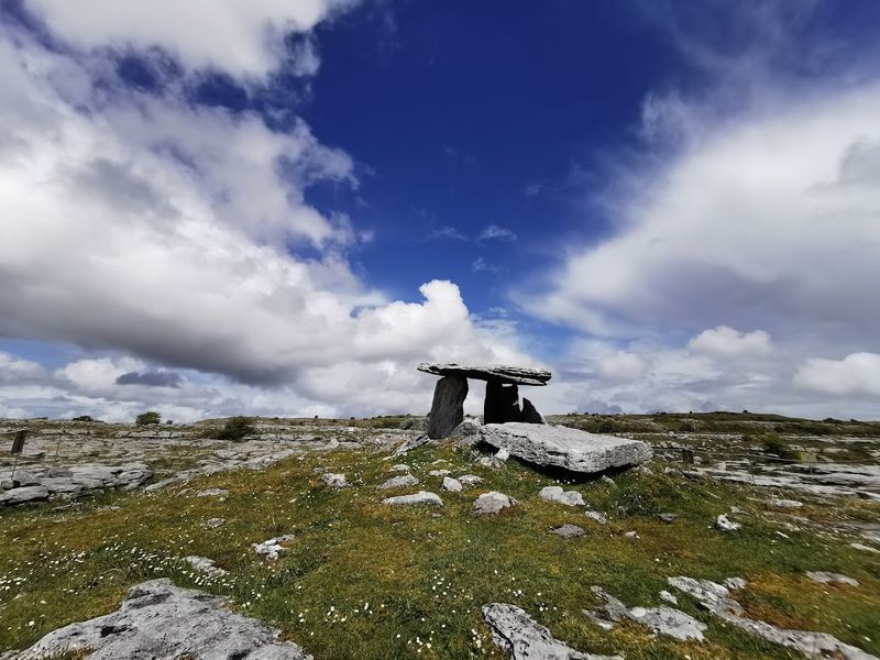
The Burren looks like the moon decided to grow wildflowers and nobody questioned it. Covering roughly 250 square kilometers of County Clare, this extraordinary landscape of bare limestone pavement seems like it belongs on another planet — until you notice the tiny orchids, gentians, and spring gentians blooming in the cracks between rocks.
It is the only place in the world where Arctic, Mediterranean, and Alpine plants grow side by side.
Scattered across the limestone are ancient dolmens, ring forts, and castle ruins that have stood for thousands of years. Poulnabrone Dolmen, a portal tomb dating back to around 4,000 BC, is one of Ireland’s most photographed prehistoric monuments and sits right in the middle of this surreal landscape.
Seeing it at sunrise, with mist curling over the pale rock, is genuinely otherworldly.
The Burren is also home to Ailwee Cave, a system of underground caverns and waterfalls that were carved out during the last Ice Age. Above ground, the landscape shifts dramatically with the seasons — wildflower-carpeted in spring, golden and windswept in autumn.
Few places in Ireland reward slow, careful exploration quite as richly as this ancient, strange, and quietly spectacular stretch of rock.
Hill of Tara — Seat of Ireland’s Ancient Kings
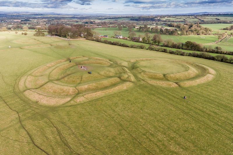
For thousands of years, this unassuming grassy hill in County Meath was the beating heart of Irish civilization. The Hill of Tara served as the ceremonial and political capital of the High Kings of Ireland, a place where rulers were inaugurated, laws were declared, and the fate of the island was decided.
Standing on its summit today, looking out over the wide green plains of Meath, you can feel the weight of all that history pressing up through the ground.
The hill is home to several ancient monuments, including the Mound of the Hostages, a passage tomb dating back around 5,000 years. The Lia Fail, or Stone of Destiny, stands at the center of the hill — legend says it would cry out when touched by Ireland’s rightful king.
Whether or not you believe the legend, the stone has a presence that demands respect.
Tara is free to visit and open year-round, which makes it one of Ireland’s most accessible ancient sites. The visitor center inside the nearby church provides essential context for understanding what you’re looking at across the hillside.
Come on a clear day if possible — the 360-degree views stretch across multiple counties and are spectacular in their own quiet, sweeping way.
Carrauntoohil — Ireland’s Rooftop
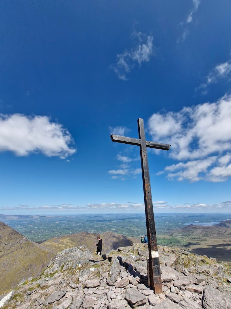
At 1,038 meters above sea level, Carrauntoohil is the highest point in Ireland, and reaching its summit feels like earning something real. The mountain anchors the MacGillycuddy’s Reeks range in County Kerry, a jagged spine of peaks that looks properly alpine in a way that surprises most first-time visitors.
Ireland’s mountains often get underestimated — Carrauntoohil makes sure that stops immediately.
The most popular route to the top is via the Devil’s Ladder, a steep gully that requires sure footing and a good set of lungs. More experienced hikers tackle the dramatic Caher ridge route, which offers knife-edge walking and panoramic views that stretch from the Dingle Peninsula to the Ring of Kerry far below.
A large metal cross marks the summit, visible from miles away on clear days.
Weather changes fast on Carrauntoohil, so proper gear is non-negotiable regardless of how sunny the morning looks at the trailhead. A map, waterproof jacket, and sturdy boots are the bare minimum.
The mountain claims lives every year from unprepared hikers, so respect is essential. Get it right, though, and the summit rewards you with the kind of view that resets your entire perspective on the world.
Lough Tay — The “Guinness Lake” in Wicklow

Seen from the right angle on the hillside above, Lough Tay looks exactly like a freshly poured pint of Guinness — dark water, white sandy shore, rocky cliffs for a glass. The nickname has stuck, and it is absolutely earned.
Nestled in a steep glacial valley in the Wicklow Mountains, this small but intensely dramatic lake is one of Ireland’s most photogenic spots, beloved by photographers who make the early morning hike worth every step.
The lake sits within the Luggala Estate, a private estate that has hosted everyone from rock stars to filmmakers over the years. The surrounding landscape has appeared in TV productions including Vikings and The Tudors, which tells you everything about how cinematic this valley actually looks.
A public viewing point on the road above offers the classic pint-shaped vista that fills social media feeds year-round.
Getting there involves a short but steep walk from the roadside parking area, and the views are best in morning light when mist lingers over the water’s surface. The surrounding Wicklow Mountains National Park offers excellent hiking routes that incorporate Lough Tay into longer day walks.
It is the kind of place that feels like a secret even after millions of people have already been there.
Hazelwood & Lough Gill — Yeats’s Inspiration
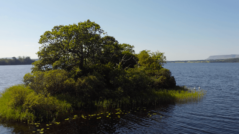
W.B. Yeats walked the shores of Lough Gill as a young man and came away with one of the most beloved poems in the English language.
The Isle of Innisfree, sitting quietly in the middle of the lake, inspired his famous lines about going there to live alone in a bee-loud glade. Standing at the water’s edge in the early morning, with mist curling off the surface and birdsong filling the air, it is impossible not to understand exactly what he meant.
Hazelwood Forest, on the northern shore of Lough Gill, offers a gentle woodland walk lined with whimsical wooden sculptures carved from local trees. The trail winds through ancient oak and hazel woodland before opening up to stunning lake views that shift with every step.
It is peaceful in a way that feels genuinely restorative rather than just pretty.
Boat trips on Lough Gill depart from Sligo town during summer, passing the Isle of Innisfree and several other small wooded islands that dot the lake. The surrounding Sligo landscape is deeply connected to Yeats — his grave is nearby at Drumcliff, beneath the shadow of Benbulben mountain.
This whole corner of Ireland feels like a living literary landscape, written in water, wood, and stone.
Hook Lighthouse — Ancient Beacon on the Wild Coast
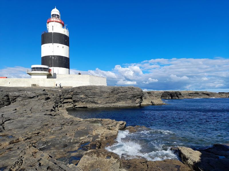
Hook Lighthouse has been warning ships away from the rocks at Hook Head for over 800 years, making it one of the oldest working lighthouses in the entire world. Built in the early 13th century by William Marshal, one of the most powerful knights in medieval Europe, the tower is constructed from stone so thick and solid that it has barely needed structural repairs in eight centuries.
That is not a typo — eight centuries.
The lighthouse stands at the tip of the Hook Peninsula in County Wexford, a narrow finger of land jutting into the Celtic Sea where the tides run fast and the wind has serious opinions. Guided tours take visitors up through the tower’s medieval interior, revealing original stonework, narrow spiral staircases, and the working light mechanism at the top.
The views from the lantern room stretch across the water toward Wales on clear days.
The surrounding coastline is excellent for rock pooling, fossil hunting, and watching grey seals haul themselves onto the rocks below. The phrase “by Hook or by Crook” is said to have originated here, referring to two routes into Waterford Harbour.
Whether or not that story is true, Hook Lighthouse earns its legendary status with every crashing wave and weathered stone.


