Most travelers flock to the same famous mountain destinations, fighting for elbow room at overlooks and paying premium prices for everything. But scattered across six continents are small mountain towns that offer equally stunning views without the tourist swarms.
These hidden gems give you the peaks, trails, and fresh alpine air you crave, minus the crowds that can ruin the experience.
Soglio, Switzerland
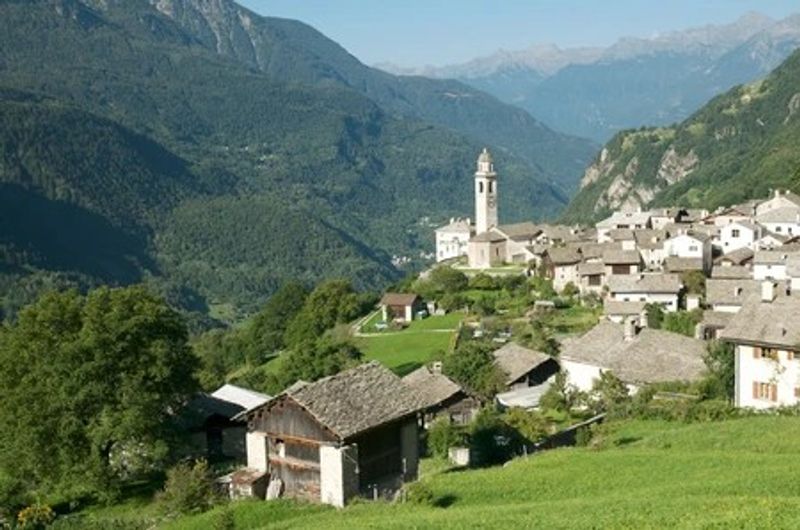
Giacometti called this place the gateway to paradise, and honestly, he wasn’t exaggerating. Soglio sits on a sunny terrace in the Bregaglia Valley, where stone houses huddle together like they’re sharing secrets.
The views stretch across to the Bondasca glacier and Piz Badile’s north face.
Walking these cobbled lanes feels like stepping into a different century. The village has barely 300 residents, so you won’t be dodging selfie sticks at every corner.
Local chestnut groves still produce nuts that end up in traditional recipes at the handful of family-run restaurants.
The Palazzo Salis, a 17th-century mansion turned hotel, anchors the village center. Its garden terrace offers mountain views that make you forget your phone exists.
September brings the best weather when summer crowds have left but the hiking trails remain open.
Getting here requires commitment since no train runs directly to town. That inconvenience keeps visitor numbers manageable.
The bus from Promontogno takes about ten minutes, winding through valleys that look like they’ve been painted rather than formed by geology. Pack layers because mountain weather changes faster than your mood on a Monday morning.
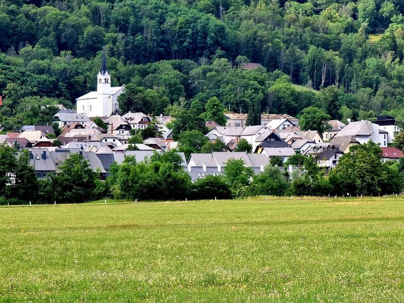
Chiavenna, Italy
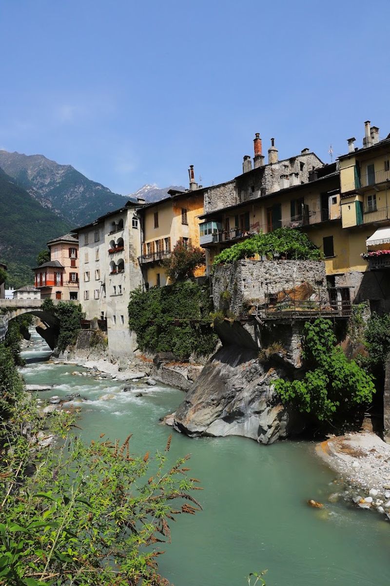
Most people speed past Chiavenna on their way to Lake Como, which works perfectly for those of us who prefer our mountain towns without the Instagram hordes. This Lombardy gem sits where three valleys converge, creating a natural crossroads that’s been important since Roman times.
The Alps loom overhead, but the town itself feels Mediterranean with its stone buildings and sunny piazzas.
The real treasure here is the crotti, natural caves formed by giant boulders where cold air flows year-round. Locals turned these into wine cellars and restaurants centuries ago.
You can eat bresaola and local cheeses in these stone chambers while staying naturally chilled, no air conditioning needed.
Chiavenna’s botanical garden showcases alpine plants in a setting that feels like a secret hideaway. The Marmitte dei Giganti, massive glacial potholes carved during the Ice Age, sit right in town.
They’re weird geological formations that look like something giants actually could have used for cooking.
Spring and fall offer the best visiting conditions. Summer brings some tourists, but nothing compared to Como’s crowds.
The local markets sell mountain honey and cheeses that taste like the Alps smell. Budget-friendly hotels line the historic center, and nobody’s charging Venice prices here.
Aiguilles, France
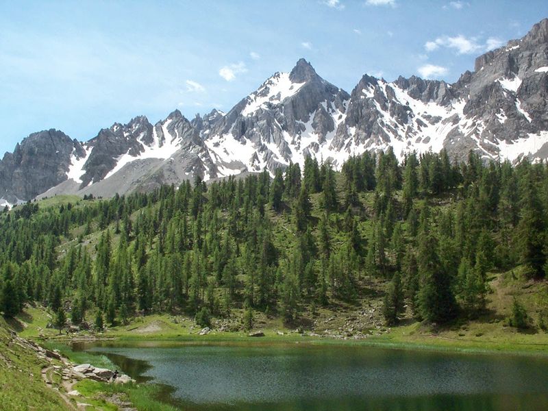
Aiguilles doesn’t show up on many tourist radars, which is exactly why it works. This Queyras village sits at 1,450 meters, surrounded by peaks that make you crane your neck.
The Guil River runs through town, and in summer, you can hear it from almost anywhere.
The architecture here is distinctly alpine, with wooden balconies and stone foundations built to handle serious snow. Unlike fancy ski resorts, Aiguilles maintains its working-village vibe.
You’ll see locals buying bread at the bakery, not posing for travel influencers.
Hiking trails fan out in every direction from the village center. The paths range from easy valley walks to serious mountain routes that require proper gear.
Mont Viso, one of the region’s iconic peaks, dominates the southern skyline. On clear days, its pyramid shape looks almost too perfect to be real.
Winter brings cross-country skiing opportunities without the lift-ticket prices of major resorts. The Queyras Regional Natural Park protects this area, limiting development and keeping things low-key.
Small guesthouses and a handful of restaurants serve hearty mountain food that focuses on substance over presentation.
July and August see the most visitors, but even then, the trails don’t feel crowded. The village celebrates traditional festivals that actually involve locals, not tourist shows.
Bovec, Slovenia
The Soča River runs through Bovec in a shade of turquoise that looks Photoshopped but isn’t. This small Slovenian town sits in a valley where the Julian Alps create a dramatic backdrop for every activity.
Adventure companies operate here, but the town hasn’t sold its soul to tourism like some mountain destinations.
Outdoor options include rafting, kayaking, canyoning, and hiking that ranges from gentle to genuinely challenging. The Boka Waterfall, one of Slovenia’s tallest, cascades down 106 meters just outside town.
The spray creates rainbows on sunny afternoons, and you can get close enough to feel the mist.
World War I history runs deep here since the Isonzo Front cut through these mountains. Museums and outdoor exhibits tell stories of brutal mountain warfare.
Hiking to old trenches and fortifications adds historical context to the stunning scenery.
Bovec maintains a lived-in feel despite the adventure tourism. Locals still outnumber visitors most of the year.
The town square has cafes where people actually read newspapers rather than just scrolling phones. Prices remain reasonable compared to Austrian or Swiss mountain towns.
September offers ideal conditions with warm days, cool nights, and fewer tourists than summer. The local cuisine blends Italian and Slovenian influences, heavy on dumplings and stews that fuel mountain activities.
Piódão, Portugal
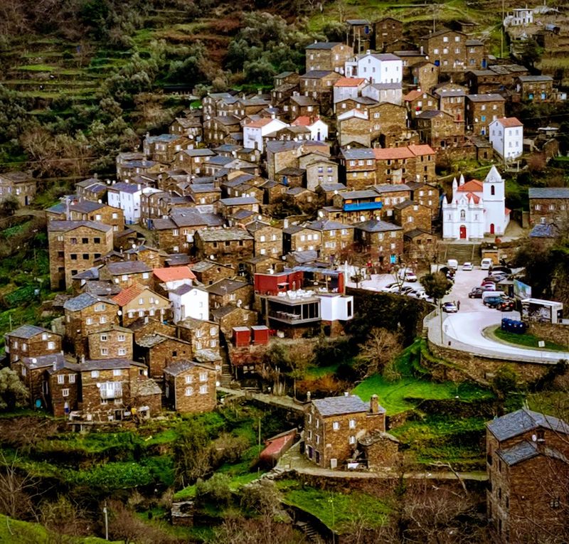
Schist villages dot central Portugal, but Piódão stands out for its dramatic mountain setting and stubborn isolation. The entire village is built from dark schist stone, creating a uniform appearance that feels almost medieval.
Houses stack up the hillside in tight rows, their slate roofs gleaming after rain.
Getting here involves winding mountain roads that make passengers nervous and drivers focused. That difficulty kept Piódão isolated for centuries.
Even now, most Portuguese tourists haven’t visited, and international travelers rarely find it.
The village church, Igreja Matriz, breaks the color scheme with its white facade standing out against all that dark stone. It’s the visual anchor of the village and the gathering spot for local festivals.
The surrounding Serra do Açor mountains offer hiking trails through forests of oak and chestnut.
Piódão has maybe 200 permanent residents, most of them older folks who remember when the village was even more remote. A handful of small restaurants serve mountain food like cabrito, roasted kid goat that’s a regional specialty.
The local cheese, queijo da serra, is worth the trip alone.
Spring brings wildflowers to the mountains, while autumn colors the forests in shades of orange and gold. Winter can bring snow, transforming the village into something from a fairy tale.
Small guesthouses offer basic accommodation without resort-style amenities or prices.
Capileira, Spain
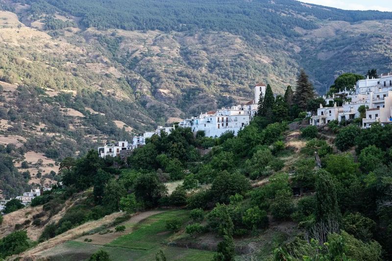
White villages cascade down the Poqueira Gorge, and Capileira sits at the top of this arrangement at 1,436 meters. The Sierra Nevada peaks rise behind town, including Mulhacén, mainland Spain’s highest mountain.
Flat roofs and whitewashed walls create the classic Alpujarras look that photographers love.
Narrow streets twist between houses in ways that make Google Maps give up. These weren’t designed for cars, so parking happens at the village edge.
Walking these lanes, you’ll spot traditional tinaos, covered passageways between buildings that create tunnels of shade.
Hiking trails lead up into the Sierra Nevada National Park, where mountain landscapes shift from Mediterranean vegetation to alpine environments. The GR-7 long-distance trail passes through, and day hikes range from easy valley walks to serious peak ascents.
Snow lingers on the highest summits well into summer.
Capileira maintains its mountain village character despite some tourism. Shops sell local crafts like the distinctive Alpujarran rugs woven in geometric patterns.
Small restaurants serve plato alpujarreño, a hearty plate of eggs, sausage, ham, and potatoes that fuels hiking.
Spring and fall offer the best hiking weather. Summer can get hot in the valleys but stays pleasant at Capileira’s elevation.
Winter brings snow to the high peaks, creating dramatic views from the village. Budget-friendly guesthouses and small hotels provide accommodation without resort prices.
Mestia, Georgia
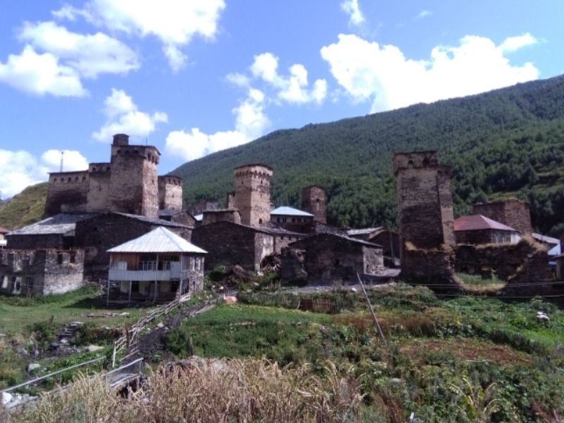
Defensive towers spike up from Mestia like stone fingers pointing at the Caucasus peaks. These Svan towers date back centuries to when highland clans needed fortified homes.
About 200 towers still stand in the region, giving Mestia a medieval skyline that’s genuinely unique.
The town sits at roughly 1,500 meters in Svaneti, a region that maintained independence and distinct culture for centuries due to its mountain isolation. Locals still speak Svan, a language unrelated to Georgian.
Traditional polyphonic singing sounds haunting when you hear it echoing off mountain walls.
Mount Ushba dominates the view with its twin peaks that look impossibly steep. Serious mountaineers tackle it, while regular hikers have plenty of valley trails and lower peaks to explore.
Glaciers hang on the highest summits, feeding rivers that cut through the valleys below.
Mestia has grown as a tourism base, but it’s still rough around the edges in the best way. New hotels mix with old stone houses, and locals still herd livestock through town.
The Svaneti Museum of History and Ethnography displays icons and manuscripts that were hidden in these mountains for centuries.
Summer brings the best hiking weather and longest days. The local cuisine features kubdari, meat-filled bread that’s perfect trail food.
Georgian wine flows freely, and the mountain air makes it go down easier than it should.
Valbona Valley, Albania
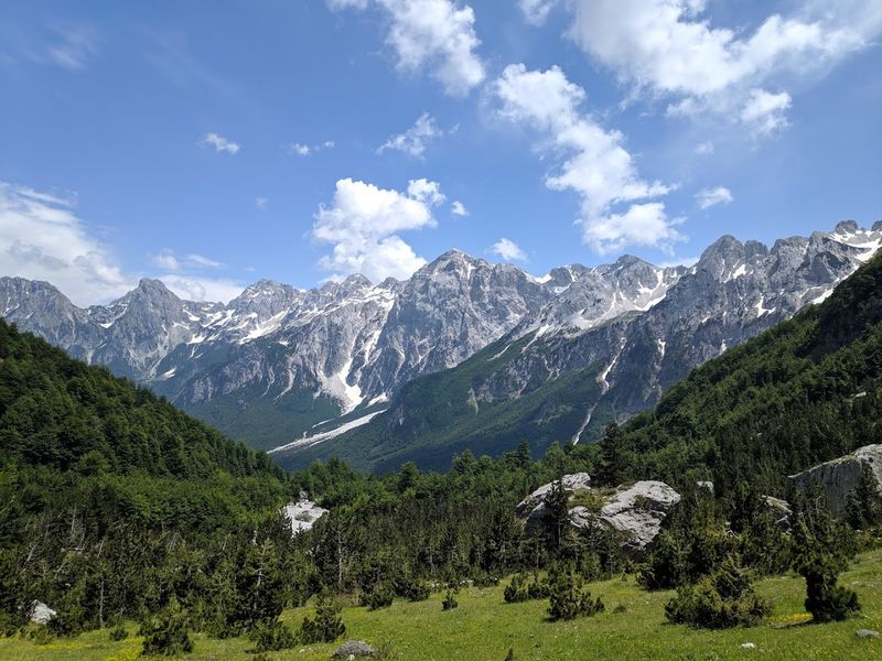
Limestone peaks saw up into the sky above Valbona Valley, creating one of those mountain landscapes that makes you stop and stare. This Albanian Alps valley sits within national park boundaries, protecting forests of beech and pine.
The Valbona River runs clear and cold, fed by mountain springs and snowmelt.
Getting here traditionally meant a ferry across Lake Koman followed by a rough road into the mountains. Recent road improvements have made access easier, but the valley still feels remote.
Small guesthouses run by local families provide accommodation and home-cooked meals.
The Valbona to Theth hiking trail ranks among the Balkans’ best day hikes, crossing a mountain pass with views that justify the climb. Longer trails lead deeper into the national park where you might spot chamois or golden eagles.
The valley itself offers easier walks through forests and meadows.
Valbona village serves as the base, a small collection of guesthouses and a handful of restaurants. Electricity came late to this valley, and some older residents remember when the only light came from fires and lanterns.
That history of isolation preserved traditional ways of life you won’t find in more accessible areas.
July and August bring the most visitors, but even peak season doesn’t feel crowded. Spring wildflowers carpet the meadows, while autumn colors the forests.
The local food emphasizes fresh ingredients, simple preparation, and generous portions that fuel mountain activities.
Jyrgalan, Kyrgyzstan
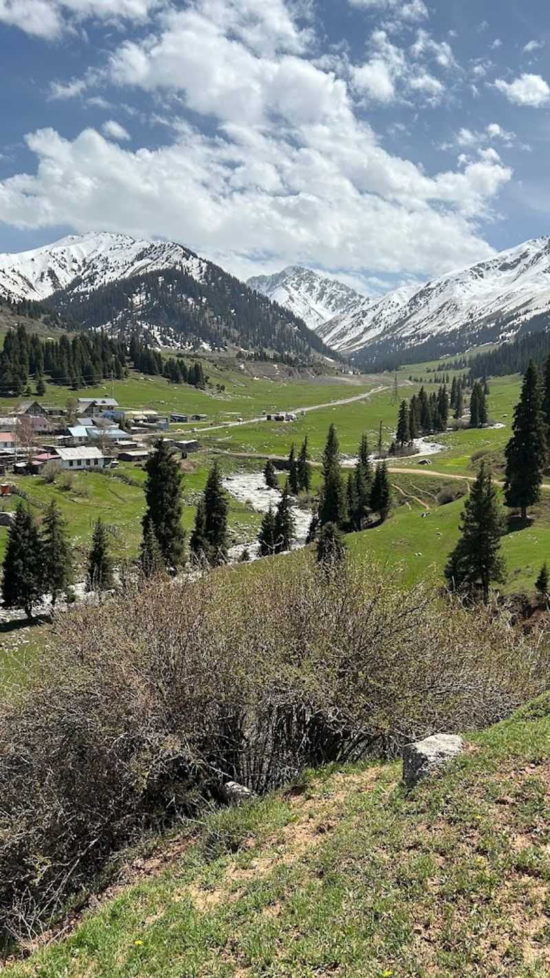
Former Soviet mining towns don’t usually end up on travel lists, but Jyrgalan reinvented itself as a trekking base after the mines closed. This remote Kyrgyz village sits in a valley surrounded by the Tian Shan mountains.
Locals decided community-based tourism beat leaving for the cities, so they built guesthouses and trained guides.
The approach to adventure tourism here focuses on keeping money in the community. Families run guesthouses, locals work as guides and horsemen, and the village collectively manages the tourism operations.
It’s a model that works better than corporate lodges parachuted into mountain regions.
Hiking and horseback riding trails lead into valleys where you won’t see another trekker all day. Multi-day routes take you to high passes and alpine lakes.
The landscapes shift from green valleys to rocky peaks to high-altitude grasslands where herders still follow traditional pastoral patterns.
Jyrgalan gets genuine winter snow, and the village has developed basic ski touring and winter trekking options. Summer remains the main season when wildflowers bloom and weather stays mostly stable.
The guesthouses serve traditional Kyrgyz food like beshbarmak, boiled meat with noodles that tastes better after a day in the mountains.
This isn’t luxury travel. Accommodations are simple, roads are rough, and amenities are basic.
That’s exactly why it works for travelers seeking authentic mountain experiences without tourist infrastructure smoothing all the edges.
Manang, Nepal
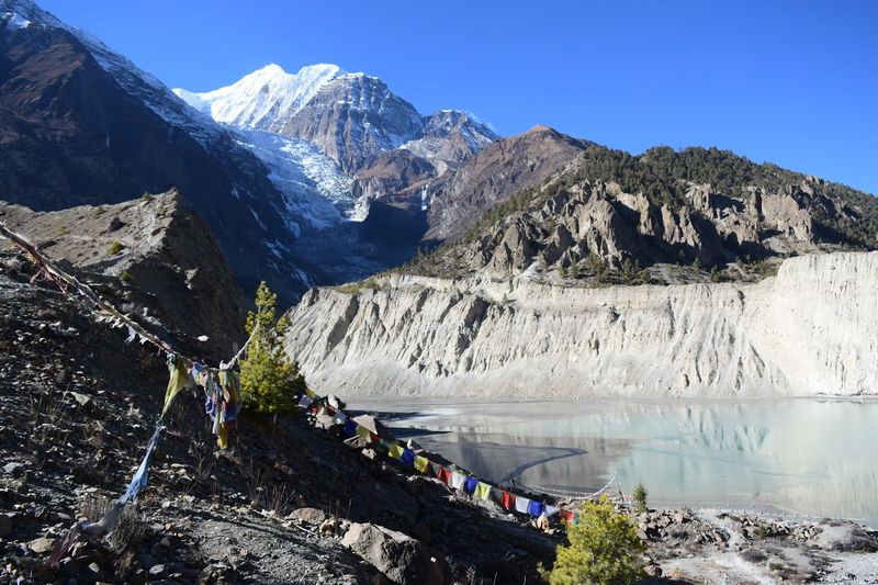
Manang sits at 3,519 meters where the air gets thin and the mountains get massive. The Annapurna range rises directly behind town, peaks stacking up like a wall of rock and ice.
This is high-altitude Nepal without the Everest Base Camp crowds.
The village serves as an acclimatization stop on the Annapurna Circuit, so it has more infrastructure than its size would suggest. Lodges and teahouses line the main street, offering basic rooms and hearty meals.
But most trekkers only stay a night or two, keeping things from feeling overrun.
Traditional flat-roofed stone houses cluster together, built to handle serious weather. Prayer flags snap in the wind, and Buddhist monasteries dot the surrounding hillsides.
The Gangapurna Lake, a short hike from town, reflects the surrounding peaks on calm mornings.
Altitude affects everyone differently, so spending an extra day here for acclimatization makes sense. Side hikes to nearby villages or up to viewpoints help your body adjust while offering stunning perspectives on the Annapurna massif.
The local bakery serves apple pie that tastes suspiciously good at this elevation.
October and November bring clear skies and stable weather, making them prime trekking season. Spring works too, though afternoon clouds can obscure the peaks.
The lodges stay basic, but hot showers and decent food make the altitude more bearable. Prices remain reasonable despite the remote location.
Yuksom, India (Sikkim)
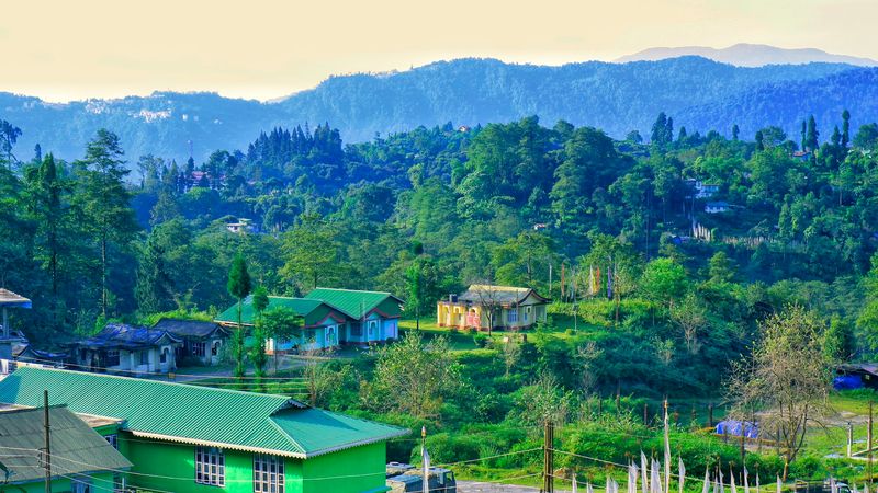
Yuksom means meeting place of three lamas, referring to the 1641 consecration of Sikkim’s first monarch here. That historical significance matters less to most visitors than the fact that this West Sikkim town serves as the gateway to Khangchendzonga National Park.
The world’s third-highest mountain looms somewhere in the clouds above, though seeing it requires luck and patience.
The trek to Goechala Pass starts from Yuksom, a multi-day route that’s considered one of the Himalayas’ most scenic. Day hikers have options too, including walks to monasteries and sacred lakes.
The forests here are thick with rhododendrons that explode with color in spring.
Yuksom maintains a quiet mountain village atmosphere despite the trekking traffic. A few guesthouses and small hotels provide accommodation, and restaurants serve Sikkimese food like thukpa and momos.
The local market operates on certain days, drawing people from surrounding villages.
The Norbugang Coronation Throne, where Sikkim’s first king was crowned, sits in a peaceful grove. Prayer wheels and stone carvings mark the site, and locals still consider it sacred.
The Dubdi Monastery, Sikkim’s oldest, requires a short uphill walk but rewards with valley views and Buddhist murals.
Spring and autumn offer the best weather windows. Monsoon rains from June to September make trails muddy and leeches active.
Winter brings cold temperatures but clear skies when the clouds cooperate. Permits are required for the national park, arranged through registered agencies.
Imlil, Morocco
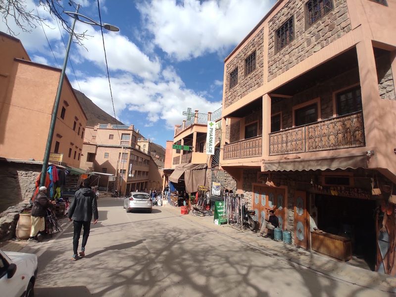
Imlil sits at about 1,800 meters in the High Atlas, where the road ends and the trails begin. Jebel Toubkal, North Africa’s highest peak at 4,167 meters, rises above the village.
Trekkers use Imlil as a base for summit attempts, but you don’t need to climb that high to appreciate the setting.
The village spreads across terraced slopes where locals still farm using traditional methods. Walnut trees shade the paths, and irrigation channels distribute water to the fields.
Berber architecture dominates, with rammed earth buildings that blend into the landscape.
Mule traffic outnumbers vehicles since steep paths connect different parts of the village. The animals carry supplies, luggage, and occasionally tired trekkers.
Their bells create a constant background soundtrack that somehow fits the mountain setting.
Day hikes from Imlil include routes to nearby Berber villages, waterfalls, and viewpoints. The Azzaden Valley trek takes you through landscapes that shift from green valleys to rocky peaks.
Local guides know the trails and can arrange homestays in remote villages.
Guesthouses and small hotels range from basic to surprisingly comfortable. The village has grown to accommodate tourism, but it hasn’t become a resort.
Tagines and mint tea fuel trekking days, and the mountain air makes everything taste better.
Spring and autumn provide ideal trekking conditions. Summer gets hot in the valleys but stays pleasant at altitude.
Winter brings snow to the high peaks, making Toubkal a serious mountaineering objective.
Tafraoute, Morocco
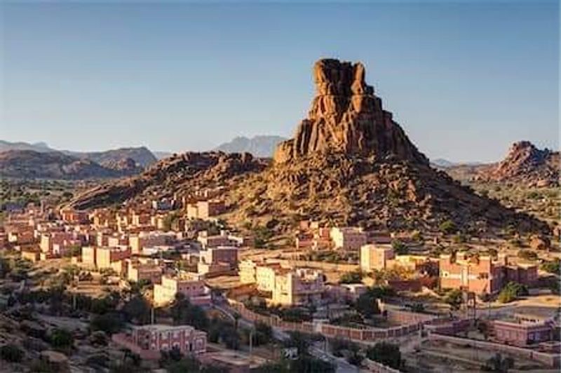
Pink granite boulders scatter across the landscape around Tafraoute like a giant’s abandoned toy collection. These surreal rock formations give the Anti-Atlas town a distinctive setting that doesn’t look quite real.
The rocks glow especially pink at sunset, creating photo opportunities that don’t need filters.
Belgian artist Jean Vérame painted some boulders bright blue in 1984, creating the Blue Rocks installation. Time and weather have faded the paint, but the rocks remain a quirky landmark.
Whether you find them artistic or ridiculous depends on your tolerance for human intervention in natural landscapes.
Tafraoute sits far from Morocco’s main tourist circuits, which keeps it relatively undiscovered. The town serves as a base for exploring Amazigh (Berber) villages in the surrounding valleys.
Traditional kasbahs and fortified granaries dot the landscape, some still in use, others crumbling picturesquely.
Hiking and rock climbing opportunities abound in the granite formations. Routes range from easy scrambles to technical climbs that require gear and experience.
The Ameln Valley, with its series of villages and palm groves, offers gentler walking through cultivated landscapes.
The town has a relaxed pace that contrasts with Morocco’s busier destinations. A weekly souk brings villagers from the surrounding area to trade goods.
Small hotels and guesthouses provide accommodation, and local restaurants serve tagines and couscous without catering to mass tourism.
February brings almond blossoms that soften the rocky landscape with pink and white flowers. Spring and fall offer comfortable temperatures for exploring.
Hogsback, South Africa
Indigenous forests cover the Amathole Mountains around Hogsback, creating a setting that feels more like Middle-earth than South Africa. Mist rolls through constantly, giving the area a moody atmosphere that inspired Tolkien, who spent childhood years nearby.
Whether the mountains actually influenced his writing remains debated, but the tourism board certainly runs with the connection.
Waterfalls cascade through the forests, with trails leading to viewpoints and swimming holes. The Madonna and Child Waterfall, the Kettlespout, and the Bridal Veil Falls all sit within easy hiking distance of the village.
The trails wind through yellowwood and Cape beech forests that have survived centuries.
Hogsback village itself is small, a collection of guesthouses, cafes, and craft shops spread along mountain roads. The vibe leans toward alternative, with artists and back-to-the-land types mixing with local Xhosa communities.
It’s not polished or particularly organized, which somehow adds to the appeal.
Mountain biking trails have developed in recent years, ranging from gentle forest rides to technical descents. The area’s elevation moderates temperatures, making it a cool escape from South Africa’s lowland heat.
Winter brings occasional snow, a rarity in this part of the country.
Accommodation options include everything from backpacker lodges to upscale cottages. The local pub serves as a gathering spot where travelers and residents mix.
Prices remain reasonable compared to South Africa’s more famous destinations. Visit during spring when wildflowers bloom, or autumn when the forests turn golden.
Aoraki / Mount Cook Village, New Zealand
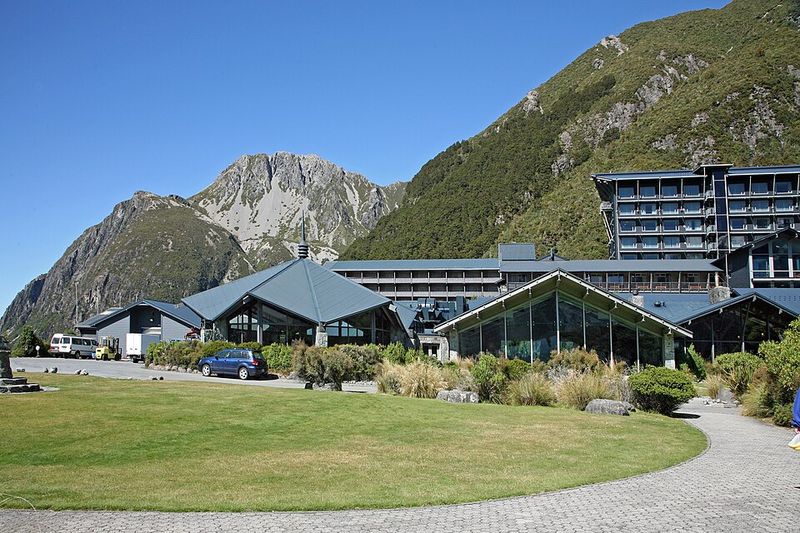
About 160 people live in Aoraki / Mount Cook Village, making it less a town and more a collection of lodges, a visitor center, and a few houses inside national park boundaries. New Zealand’s highest peaks surround the village, including Aoraki / Mount Cook itself at 3,724 meters.
The Southern Alps dominate every view.
Glaciers flow down from the high peaks, though they’re retreating like glaciers everywhere. The Tasman Glacier, New Zealand’s longest, stretches 23 kilometers from the mountains.
Boat tours run on the terminal lake, navigating between icebergs that have calved off the glacier face.
Hiking trails range from short walks to serious alpine routes. The Hooker Valley Track, an easy three-hour return walk, leads to a glacial lake with mountain reflections.
Longer routes require mountaineering skills and proper equipment. The village serves as a base for climbers attempting the big peaks.
The night sky here earned International Dark Sky Reserve status, meaning the stars actually look like stars instead of distant city lights. On clear nights, the Milky Way stretches across the sky in ways that make you understand why ancient peoples invented astronomy.
Accommodation options are limited and pricey, typical for a national park location. The Hermitage Hotel dominates, but there’s also a hostel and camping options.
Booking ahead is essential, especially in summer.
Summer brings the most stable weather, though conditions can change rapidly in the mountains. Winter transforms the area into serious mountaineering terrain with avalanche risks and technical climbing conditions.
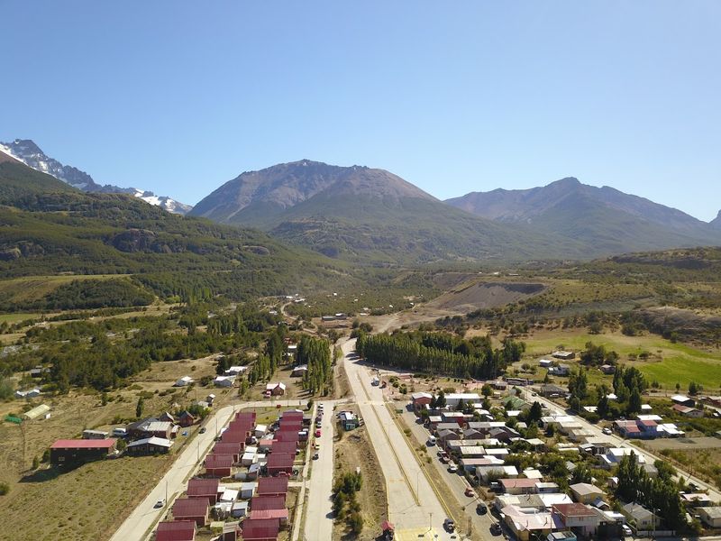
El Bolsón, Argentina
El Bolsón sits in a valley between mountain ranges, creating a microclimate that’s milder than surrounding Patagonia. The town developed a countercultural reputation in the 1970s when hippies and draft dodgers settled here.
That alternative vibe persists, though tourism and craft beer have joined the scene.
Piltriquitrón Mountain rises behind town, its summit accessible via hiking trails that reward with valley views. The Bosque Tallado, a sculpture forest where artists carved dead trees into artworks, makes for an unusual mountain walk.
Some sculptures are striking, others are weird, all are unexpected in this setting.
The town’s craft fair operates several days a week, selling everything from leather goods to homemade jams. Local breweries have proliferated, and sampling Patagonian craft beer has become a legitimate activity.
The hoppy ales taste especially good after mountain hikes.
Waterfalls dot the surrounding mountains, with trails leading to cascades like Cascada Escondida and Cascada Mallín Ahogado. The walks range from easy strolls to full-day hikes.
Swimming holes form below some falls, though the water stays glacier-cold year-round.
El Bolsón maintains a relaxed pace despite growing tourism. The mountain scenery delivers without the infrastructure or crowds of more famous Patagonian destinations.
Accommodation ranges from campgrounds to comfortable hotels, and restaurants serve Patagonian lamb and trout.
Summer brings the longest days and warmest weather. Autumn colors the forests in shades of red and gold.
Winter means snow on the peaks and a quieter town atmosphere.
Villa Cerro Castillo, Chile
Villa Cerro Castillo amounts to a few dozen houses along Chile’s Carretera Austral, the legendary highway that winds through Patagonian wilderness. The jagged peaks of the Cerro Castillo massif rise behind the village, their castle-like spires giving the place its name.
This is Patagonia at its raw and remote.
The Cerro Castillo Reserve protects the surrounding mountains and valleys, offering hiking trails that see a fraction of Torres del Paine’s traffic. The main trek takes four days, circling the massif through landscapes of hanging glaciers, turquoise lakes, and southern beech forests.
Day hikes provide shorter options for those without camping gear or time.
The village itself offers basic services, a few guesthouses, and a small restaurant or two. This isn’t a tourism town trying to be cute.
It’s a functional base where locals work in ranching and tourism supplements rather than dominates the economy.
Guanacos, wild relatives of llamas, roam the surrounding valleys in herds. Condors soar overhead, their massive wingspans unmistakable against the sky.
The wildlife here feels less habituated to humans than in more visited parks.
The Carretera Austral’s rough gravel surface and remote location keep visitor numbers manageable. Summer offers the most reliable weather, though Patagonian winds blow year-round.
The village serves as a logical stopping point for those driving the highway, breaking up the long stretches between towns.
Accommodation stays basic and prices reasonable. The mountain views come free with every glance out the window.


