New Jersey does not always get credit for its outdoor adventures, but one trail in the northwestern corner of the state is quietly earning a reputation that stretches far beyond state lines. The Red Dot Trail up Mt.
Tammany is the kind of hike that starts with a simple parking lot and ends with wide-open views of the Delaware River cutting through the mountains below. It is steep, rocky, and physically demanding in a way that catches plenty of first-timers off guard.
But the payoff at the top is the kind of reward that makes hikers come back season after season, sometimes multiple times a year, just to experience it again from a different angle.
Where the Trail Begins: Location and Access
Before the climb begins, there is the matter of getting there. The Mt.
Tammany Red Dot Trail is located in the Kittatinnies Region, Hardwick Township, NJ 07825, sitting along the Delaware Water Gap on the New Jersey side of the border.
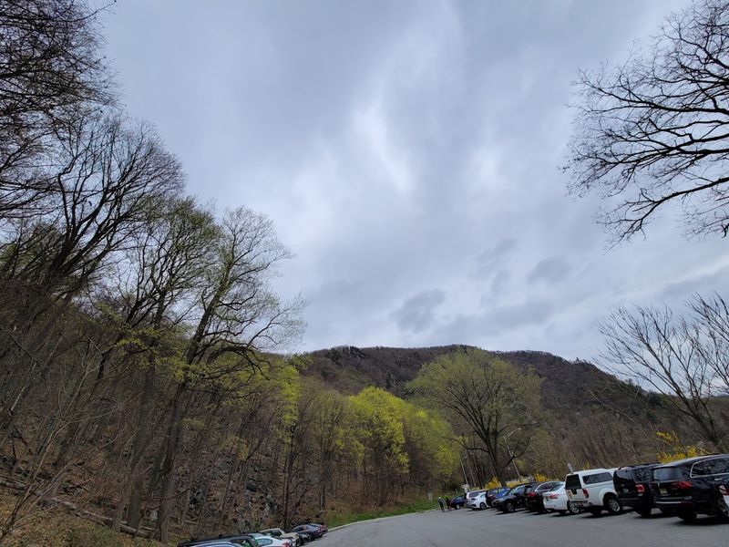
The trailhead is accessible off Route 80 West, and two parking lots serve hikers in the area. Parking Lot 1 is closer to the highway exit and has fewer spots, while Parking Lot 2 offers more space just a short distance ahead.
A connecting road links the two lots, so there is no need to re-enter the highway to switch between them.
Parking fills up quickly, especially on weekend mornings during peak seasons. Arriving before 8 a.m. on a Saturday or Sunday is the safest strategy for securing a spot without stress.
Park police are present and actively direct hikers when lots reach capacity, and roadside parking in marked no-parking zones will result in a ticket.
What Kind of Hike Is This, Really
Mt. Tammany’s Red Dot Trail does not ease hikers in gently.
From nearly the first steps, the trail climbs at a steep incline with rocky terrain, exposed roots, and sections that require some light scrambling over boulders.
The full loop using the Red Dot Trail up and the Blue Dot Trail down covers approximately 4.5 miles and involves roughly 1,300 feet of elevation gain. Most hikers complete the loop in somewhere between 2.5 and 5 hours depending on fitness level and how many breaks they take along the way.
The trail is rated moderate to difficult, and that rating leans harder for anyone who does not hike regularly. The Red Dot Trail takes the steeper, more technical route to the summit, which is why most experienced hikers recommend going up on the red and coming down on the comparatively gentler blue.
Well-marked blazes throughout the trail keep navigation straightforward, even for those using the route for the first time.
The Climb Up: What to Expect Underfoot
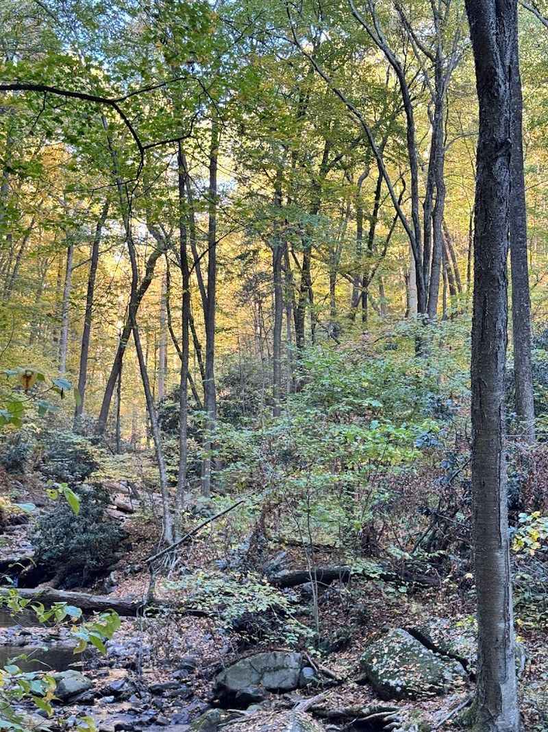
Much of the ascent on the Red Dot Trail runs through the shade of a dense forest canopy, which provides welcome cover during summer months. The path underfoot shifts frequently between packed dirt, flat rock slabs, loose stones, and sections where tree roots create natural but uneven steps.
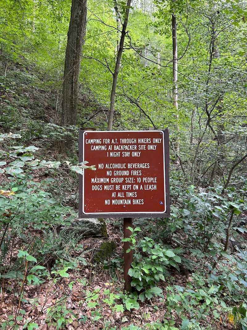
There are stretches that require using both hands to navigate rock faces, which is light scrambling rather than technical climbing, but it does mean the trail is not accessible for everyone. Hikers should stay on the marked trail at all times, as the area is a sensitive ecological zone and veering off the path causes real damage to the surrounding environment.
The trail rewards patience. Taking steady breaks rather than pushing through exhaustion makes the climb more manageable, and there are natural resting spots along the way where the view opens up briefly before the full summit reveal.
The first hour of climbing is the most demanding, and the trail eases slightly as it approaches the top.
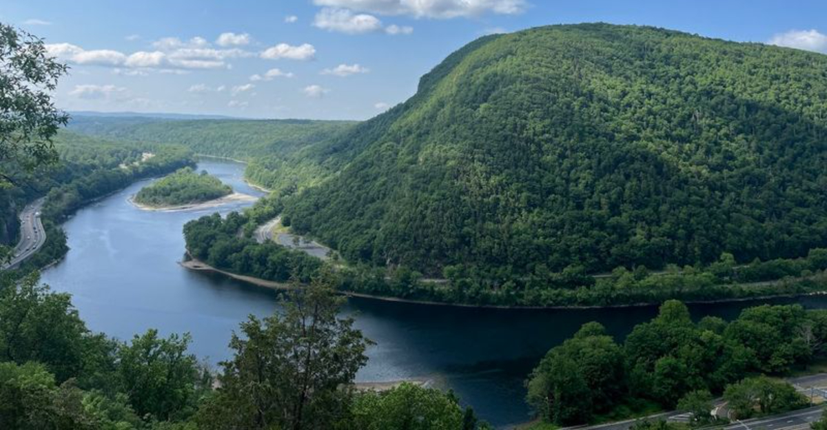
Summit Views That Justify Every Step
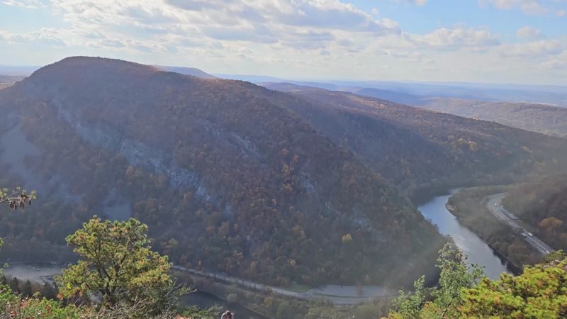
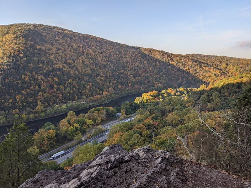
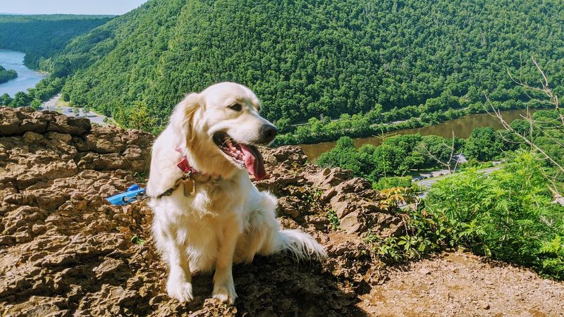
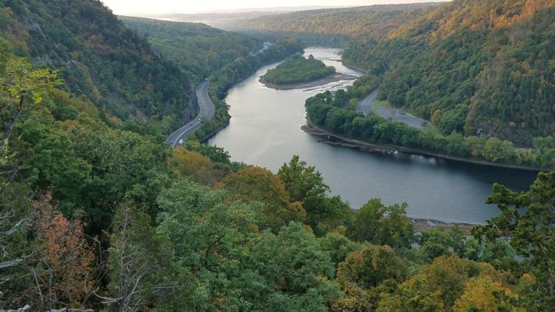
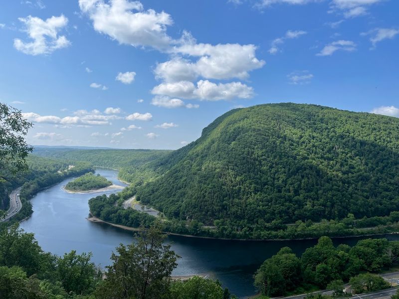
At the top of Mt. Tammany, the trees give way to open rocky outcroppings with sweeping, unobstructed views of the Delaware River winding through the valley below.
The Pennsylvania mountains stretch out across the opposite bank, and on a clear day the view extends far in both directions along the river corridor.
The summit is a social spot as much as a scenic one. Hikers spread out across the rocks, pull out snacks, and spend time taking in the view before starting the descent.
On popular weekends and fall weekends especially, the top sees a consistent flow of people arriving and departing, though the space is large enough that it rarely feels uncomfortably crowded.
Fall is the most popular season for good reason. The foliage across the Delaware Water Gap turns vivid shades during October, and the summit offers a front-row position for taking it all in.
Even in late summer, leaves begin to cover the ground, which means hikers should watch their footing carefully on the way back down.
The Blue Dot Trail: A Different Route Down
After the summit, most hikers transition onto the Blue Dot Trail for the descent, and the character of the hike shifts noticeably. The blue route is longer and less steep than the red, winding through forested sections with a gentler grade that is easier on tired legs and knees.
That said, the Blue Dot Trail is not a casual stroll. It still features rocky stretches and requires attention underfoot, particularly in sections where the trail narrows near the stream.
Some hikers who expect a flat and easy path down find themselves surprised by how technical parts of the blue route still are.
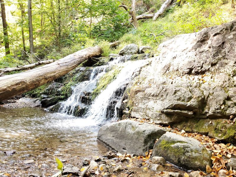
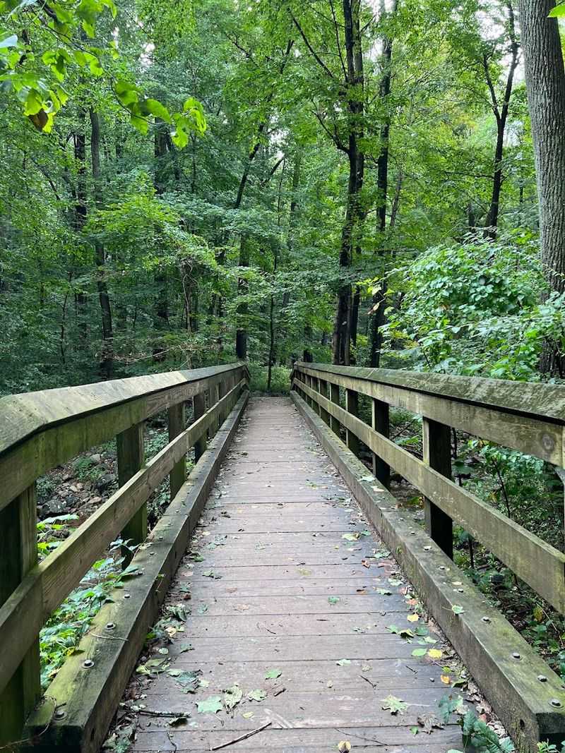
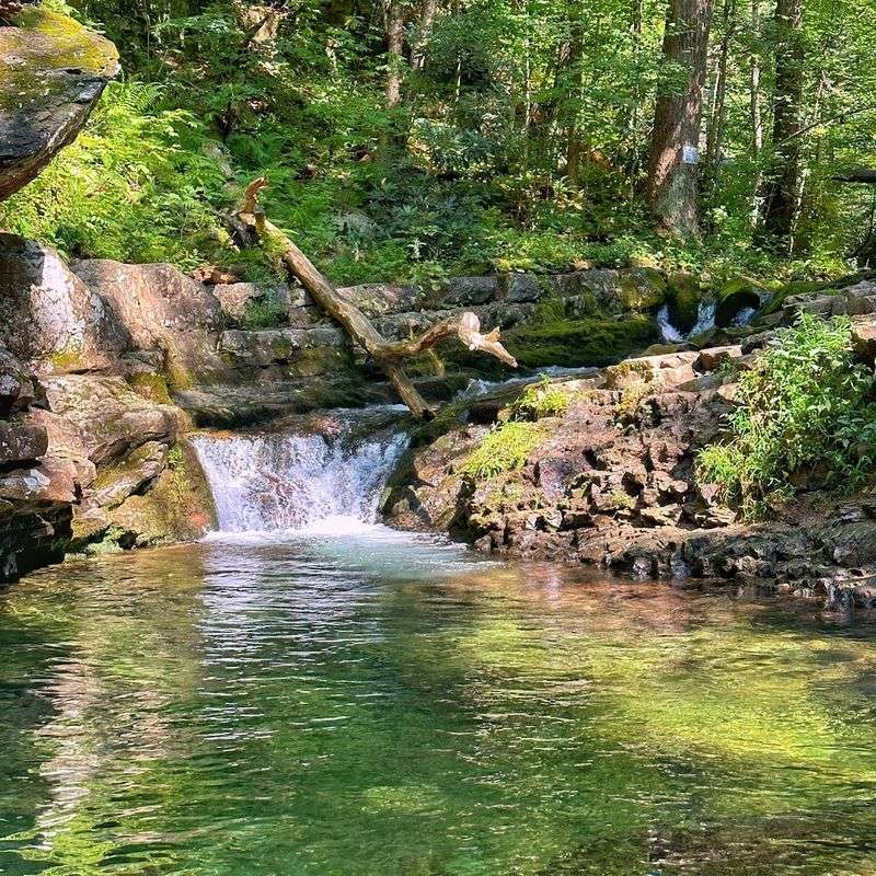
Near the bottom of the Blue Dot Trail, a small waterfall and a stream crossing via a footbridge add a pleasant finishing note to the loop. The water area is a natural gathering spot, and on busy days it can draw a crowd.
Completing the full red-up, blue-down loop brings hikers back to the parking area, though note that the exit may land at a different lot than where the hike started.
Timing Your Visit: Seasons and Crowds
Mt. Tammany draws hikers year-round, but the experience varies significantly depending on when a visit happens.
Summer weekends are the busiest periods by far, with parking lots filling up early and the trail seeing high foot traffic throughout the day. Weekdays in any season offer a noticeably quieter experience with more room to move at a comfortable pace.
Fall is the peak season for scenic value. October brings the most spectacular foliage across the Delaware Water Gap, and the combination of cooler temperatures and vivid color makes it the most popular time of year.
Arriving early on fall weekends is essential rather than just advisable, as parking can become a genuine obstacle by mid-morning.
Spring and early summer bring lush green forest cover and flowing water features on the Blue Trail. Late summer sees leaves beginning to fall and cover the trail surface, creating slippery conditions that require extra caution.
The trail is open 24 hours a day every day of the week, giving hikers flexibility to start early and avoid the heaviest crowds.
Bringing Kids and Pets Along
The question of whether to bring children or dogs on the Red Dot Trail gets a genuinely mixed answer from the hiking community. Some families with kids as young as seven and ten have completed the loop without major difficulty, while others find the steep and rocky terrain far more demanding than expected when managing young children.
For parents considering the hike with kids, keeping children close at all times on the steeper sections is critical. The exposure on some rocky outcroppings and the scrambling required in certain areas demands full adult attention.
Children who are comfortable on uneven terrain and physically active tend to handle the trail better than those new to hiking.
Pets are technically allowed on the trail, but the rocky scrambles and steep sections can be genuinely difficult for dogs, especially smaller breeds. Some owners end up carrying their dogs through the more technical passages.
Anyone bringing a dog should be prepared to assist them through challenging sections and carry extra water for the animal as well.
Trail Etiquette and Leave No Trace
Mt. Tammany sees thousands of visitors each year, and the pressure of that foot traffic shows in areas where trail etiquette breaks down.
Litter is an ongoing issue, particularly near the waterfall and stream area at the bottom of the Blue Trail, where people sometimes gather for extended periods and leave garbage behind.
The trail community has a strong culture of picking up trash when encountered, and many regular hikers carry an extra bag specifically for this purpose. The principle is straightforward: a clean trail stays open and accessible, and keeping it that way is a shared responsibility rather than someone else’s job.
On the trail itself, hikers moving uphill have the right of way by convention, and faster hikers stepping aside to let slower groups pass is standard practice. The trail is narrow in places, and groups spreading across the full width can create bottlenecks.
Staying on marked paths is non-negotiable, both for personal safety and to protect the surrounding ecological zone from further damage.
Physical Fitness and Who Should Attempt This Hike
The Red Dot Trail is not a beginner hike, and being honest about that upfront saves a lot of people from a very difficult afternoon. Hikers who are not accustomed to regular cardio exercise will find the sustained steep climb physically taxing in a way that flat-terrain walking does not prepare anyone for.
That said, the trail is not exclusive to elite athletes. Groups with mixed fitness levels have completed the full loop together, adjusting the pace and taking breaks as needed.
The key is building in time for rest rather than trying to push through the steepest sections without stopping. The total hike typically takes between 2.5 and 5 hours depending on the group.
Anyone with respiratory conditions, particularly asthma, should consult a doctor before attempting the trail due to the elevation and physical demands. The remote location means that if something goes wrong on the mountain, help is not immediately at hand.
Starting the hike well-hydrated, wearing appropriate footwear, and not underestimating the elevation gain are the three most practical pieces of advice for first-timers.
The Delaware Water Gap: The Bigger Picture
Mt. Tammany sits within the Delaware Water Gap National Recreation Area, which straddles the border between New Jersey and Pennsylvania.
The Gap itself is a natural passage where the Delaware River cuts through the Kittatinny Mountains, and Mt. Tammany rises sharply on the New Jersey side of that passage.
The recreation area covers over 70,000 acres and includes forests, rivers, wetlands, and numerous trails beyond just Mt. Tammany.
The broader landscape provides context for why the summit views are so striking. The river below is wide and prominent, and the mountains on the Pennsylvania side, including Mt.
Minsi directly across, create a natural amphitheater visible from the top.
The Delaware Water Gap has been a destination for outdoor recreation for well over a century, drawing visitors for hiking, swimming, fishing, and camping across its various zones. Mt.
Tammany is consistently ranked as one of the most rewarding hikes within the entire recreation area, which is a competitive field given the quality of trails available on both sides of the river.
Why Regulars Keep Coming Back
For a trail this demanding, the return visitor rate is remarkably high. Plenty of hikers who have completed the Red Dot Trail multiple times cite different seasons as the main draw, noting that the same route looks and feels like a genuinely different experience in spring, summer, and fall.
The consistency of the reward at the top is a major factor. The summit view of the Delaware River does not disappoint regardless of how many times a hiker has seen it before.
There is something about the combination of physical effort and open sky that makes the payoff feel earned rather than incidental.
The trail also has a community dimension that regular visitors appreciate. Friendly exchanges between hikers on the way up and down are common, and the shared experience of tackling a genuinely challenging climb creates an easy camaraderie.
More than a few people who started hiking at Mt. Tammany have gone on to pursue more ambitious trails elsewhere, crediting this one as the hike that got them started.
Planning Your Visit: Practical Tips Before You Go
A few practical details make the difference between a smooth trip and an avoidable headache. There are no bathroom facilities at the trailhead, so planning accordingly before arriving is a must.
The trail is open 24 hours a day, which makes early morning starts entirely feasible and genuinely worthwhile for avoiding crowds and securing parking.
Layering clothing is a good strategy, particularly in spring and fall when temperatures at the summit can differ noticeably from conditions at the trailhead. Cell service in the area can be inconsistent, so downloading a trail map offline before leaving home is a practical precaution rather than an overreaction.
The trail is well-marked throughout, but having a GPS-enabled map app as a backup adds confidence, especially for first-time visitors who want to confirm they are staying on the correct route. More information about the trail, including current conditions and additional route options, is available at njhiking.com/mt-tammany.
Going prepared turns a challenging hike into a genuinely memorable one rather than a stressful ordeal.


