There is a spot in northern Michigan where the ground simply ends, and what opens up in front of you is 450 feet of pure, unobstructed sky meeting water. I had heard people talk about it in hushed, almost reverent tones, and I figured they were probably exaggerating.
They were not. The Empire Bluff Trail in Empire Township, Michigan, is one of those rare places that delivers exactly what it promises, and then quietly exceeds it.
The trail winds through a beech-maple forest before spitting you out onto a sandy ridge with views that stretch so far across Lake Michigan that on a clear day you can see Wisconsin, 54 miles away. I want to walk you through everything I experienced there, from the geology under your feet to the best time to show up, so you can plan a visit that is genuinely worth the trip.
Where the Trail Begins: Address and Location
The Empire Bluff Trail sits inside the Sleeping Bear Dunes National Lakeshore, and its trailhead is accessed from Wilco Road in Empire Township, MI 49640, just outside the small town of Empire in Leelanau County, Michigan.
Getting there is straightforward. From the town of Empire, you head south on M-22 and then follow signs toward the trailhead parking area, which is a short drive off the main road.
The parking lot is modest but functional, and it fills up quickly on summer weekends, so arriving early is a smart move. The National Park Service manages the area, and a valid Sleeping Bear Dunes park pass is required for entry.
This is not a hidden backroads secret that only locals know about. It shows up on maps, it has clear signage, and the NPS has done a solid job making the access point easy to navigate for first-time visitors.
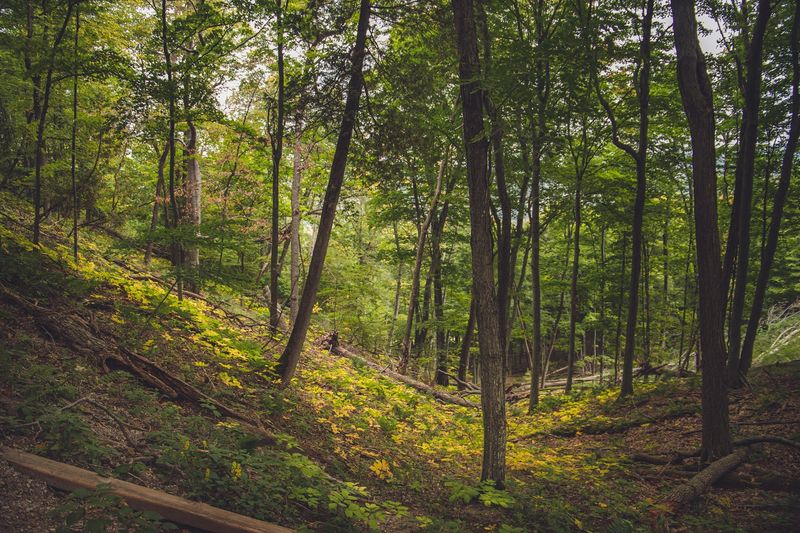
The Trail Itself: A Walk Through Beech-Maple Forest
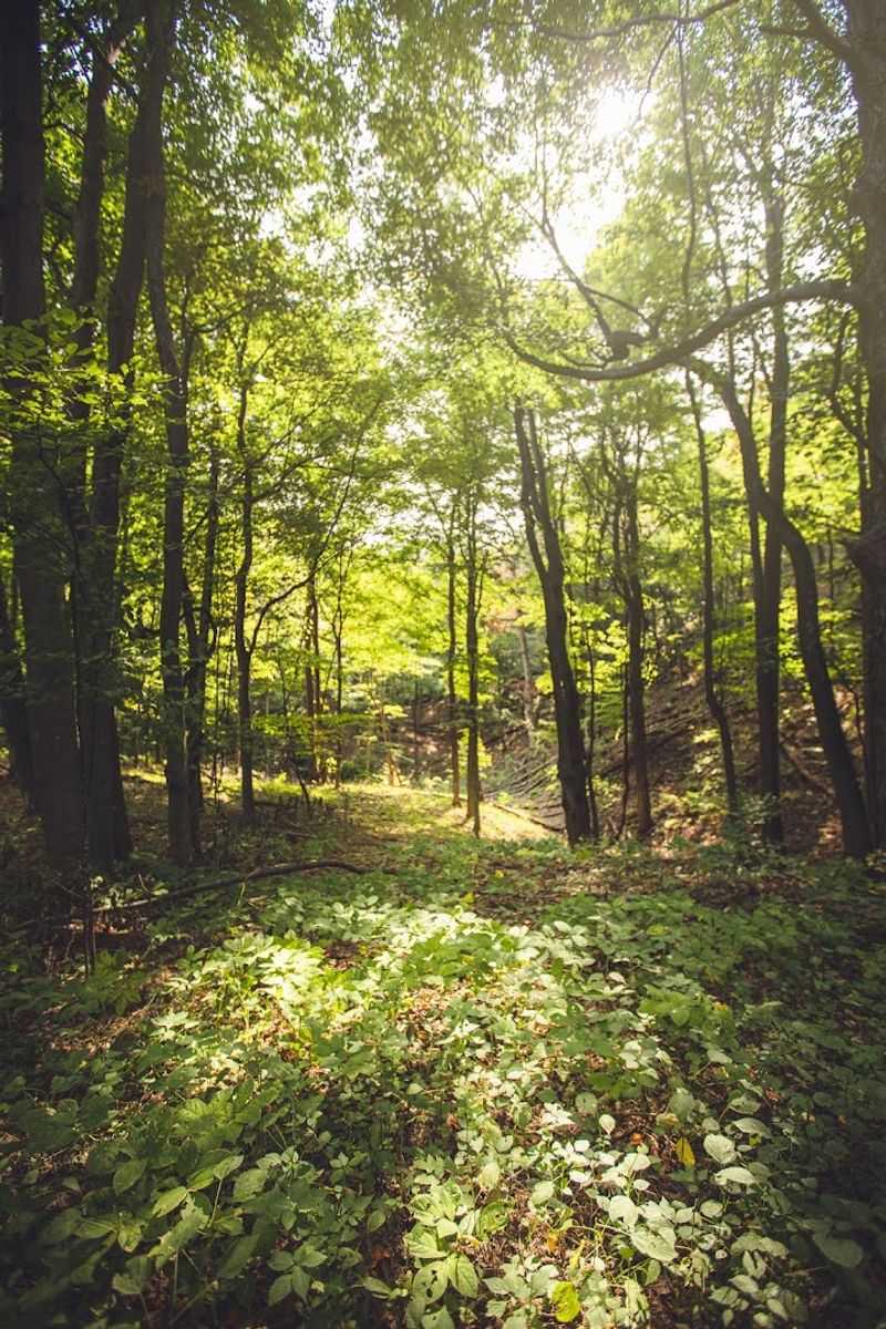
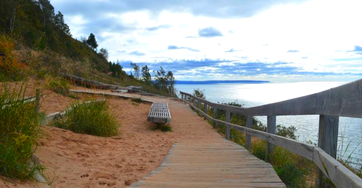
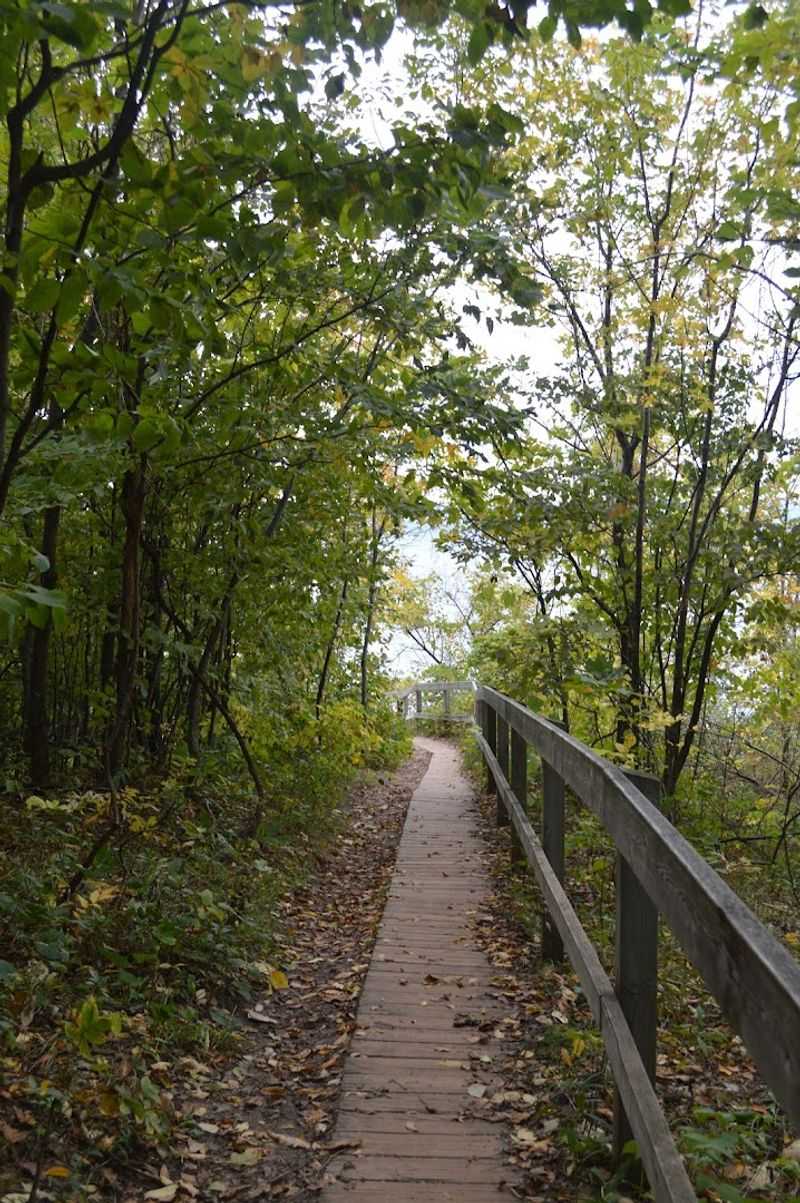
Before the big reveal at the top, the trail treats you to nearly a mile of quiet forest walking that most people underestimate. The path cuts through a mature beech-maple forest, and the canopy overhead filters the sunlight into soft, shifting patches on the ground.
The trail is about 1.5 miles round trip, which makes it accessible for most fitness levels. The first stretch is relatively flat and easy, packed dirt underfoot with tree roots here and there that keep you paying attention.
Then the path transitions. As you near the bluff, the ground shifts from firm soil to loose sand, and your legs start working a little harder.
That sandy section is short but noticeable, and it serves as a kind of dramatic buildup before the landscape opens up completely.
The forest section alone is worth the walk on a hot summer day, since the shade keeps things cool and the birdsong makes the whole experience feel genuinely peaceful.
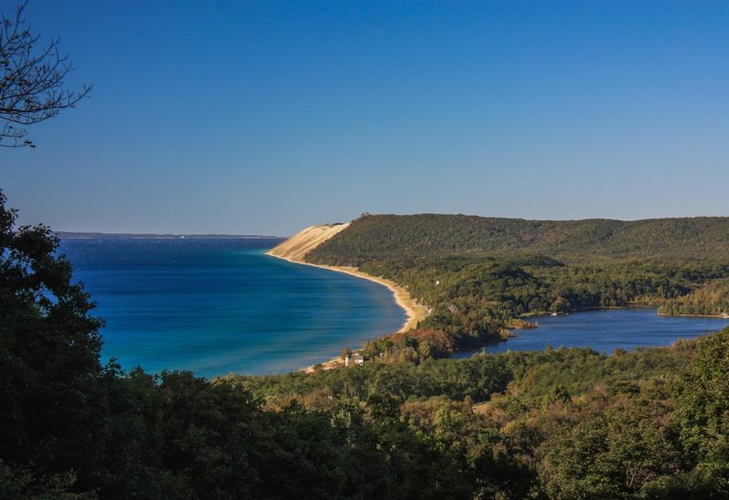
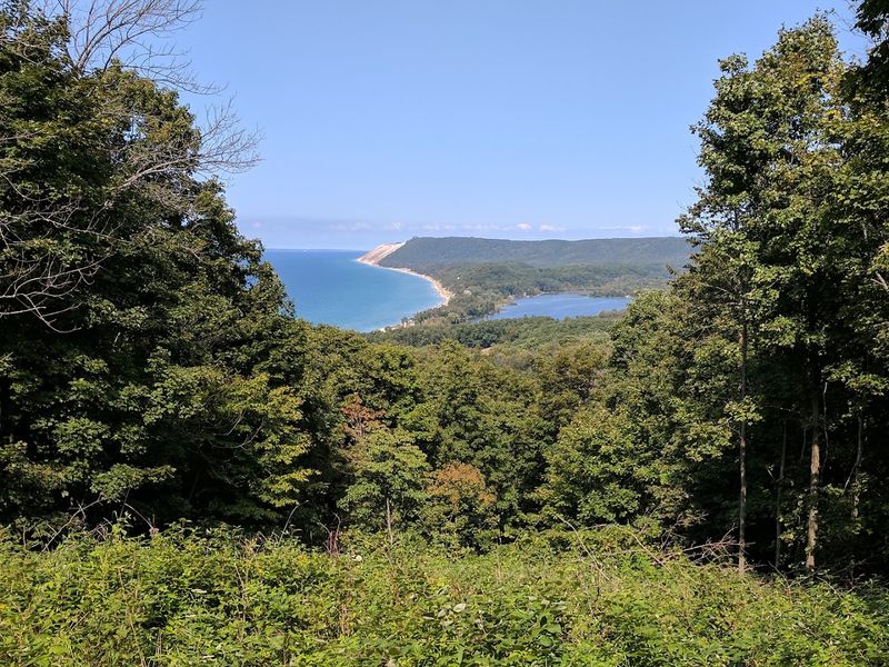
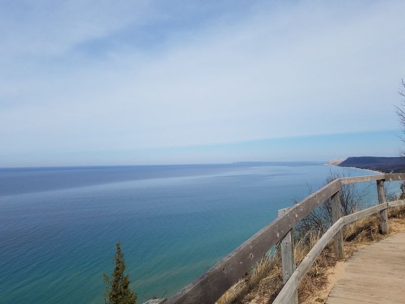
The Overlook: Standing at 450 Feet Above Lake Michigan
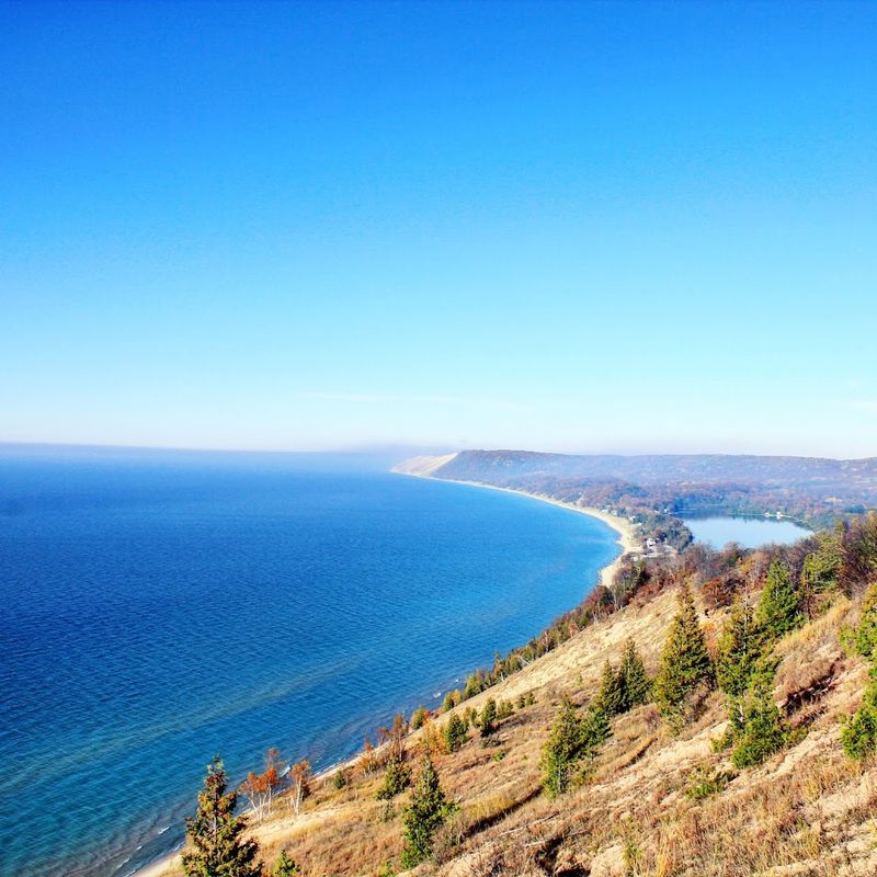
Nothing I read beforehand actually prepared me for the moment the trees parted and the bluff edge appeared. The drop is 450 feet straight down to the water, and Lake Michigan spreads out in front of you in a shade of blue that shifts between turquoise near the shore and deep navy toward the horizon.
The scale of it is hard to process at first. You are standing on sand, which feels like an odd material to be standing on at that height, and the lake below looks both close and impossibly far at the same time.
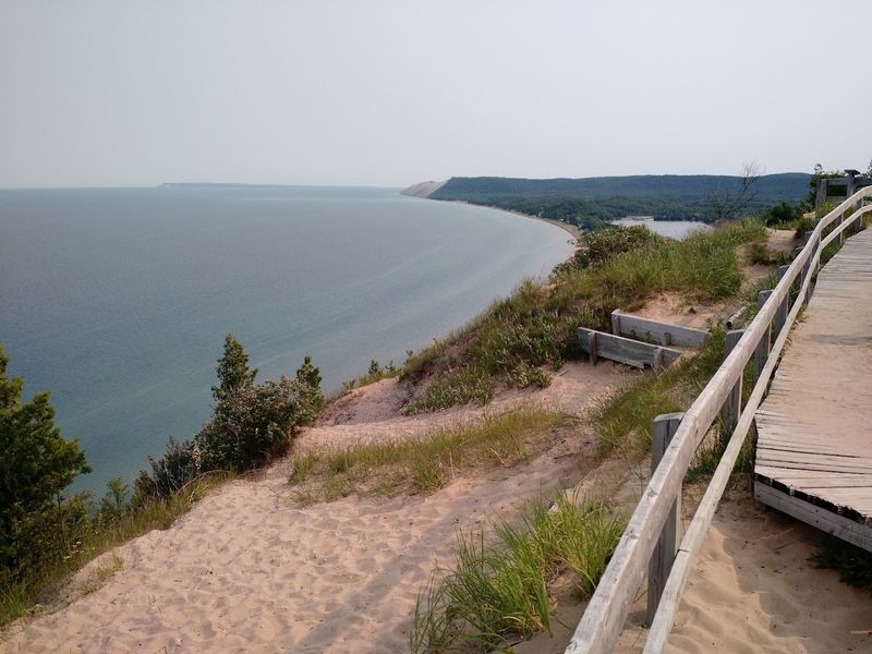
On a clear day, the view stretches 54 miles west across the water to Wisconsin, which is a fact that sounds made up until you are actually standing there squinting at the distant shoreline. The overlook has a small barrier area and interpretive signage that adds helpful context to what you are seeing.
Few viewpoints in the Midwest hit quite this hard on a clear afternoon.
What You Can See From the Top: A Panorama Worth Studying
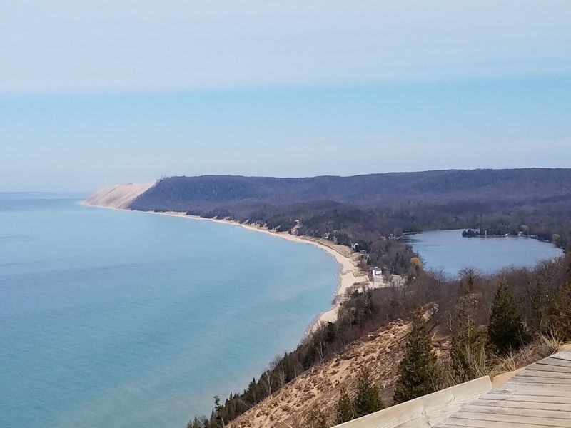
The view from the top is not just pretty, it is geographically informative in a way that rewards a few minutes of careful looking. From the overlook, you can spot Empire Bluffs about 4 miles to the south, and Platte Bay sits roughly 9 miles away in the same direction.
Point Betsie, the farthest visible point of land, appears about 15 miles to the south on clear days, its lighthouse just barely distinguishable as a white speck on the shoreline. To the west, on days with excellent visibility, the Wisconsin coastline appears as a faint dark line at 54 miles out.
The NPS has placed interpretive panels at the overlook that label each landmark, which makes the experience feel more like reading a living map than just staring at water.
I spent a good twenty minutes up there just tracking the horizon and identifying each point, and it turned what could have been a quick photo stop into something genuinely absorbing and educational.
The Geology Beneath Your Feet: A Bluff in Motion
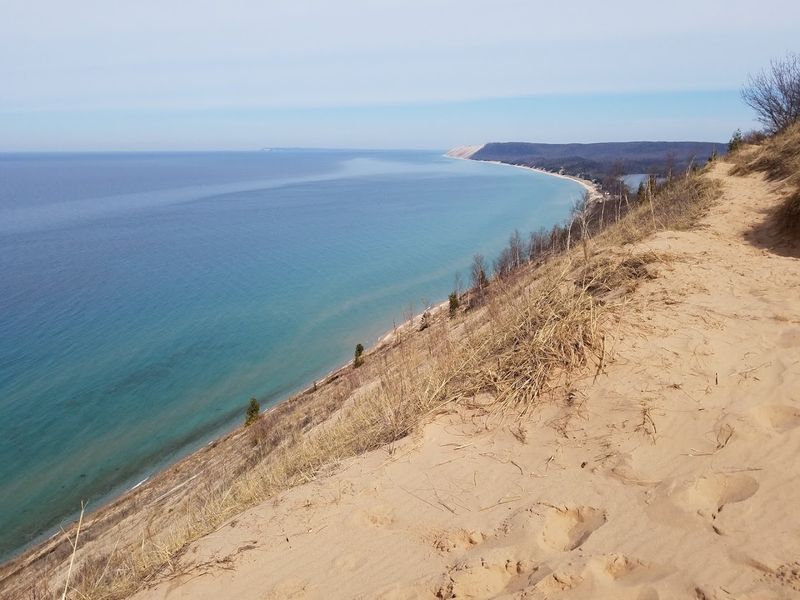
The ground you are standing on at the overlook is not as permanent as it feels. The bluff has been eroding at a rate of roughly one foot per year, which means the edge you are looking over today was about a foot further out last year.
Waves hit the base of the bluff and eat away at the sand and rock there, which causes material from higher up to slide down to the beach below. The NPS interpretive panels explain that the bluff likely once extended about 2 miles further into the lake, forming a peninsula that has since been claimed by the water.
That is a slow but relentless process, and standing at the edge with that knowledge makes the whole experience feel a little more charged. You are not just looking at a scenic view, you are watching geology happen in real time, just at a pace too slow for a single visit to capture.
The sandy beach at the base of the bluff is the accumulation of centuries of this same process.
Safety at the Edge: What the Signs Are Telling You
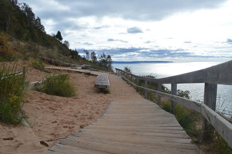
There are warning signs at the overlook for good reason, and they deserve more attention than a quick glance before stepping closer to the edge. Descending the bluff is not officially prohibited, but the NPS strongly discourages it, and once you see the steepness in person, the reason becomes obvious.
The sand is loose and the angle is severe. Going down is the easy part, but climbing back up is exhausting work, and the ascent can take much longer than visitors expect.
Beyond personal difficulty, there is also the issue of dislodged rocks and sand, which can slide toward anyone below.
The beach at the base is accessible via other routes that are far safer and more enjoyable for swimming and shoreline walking. There is no good reason to scramble down the bluff face when a proper access point exists nearby.
Treat the overlook as exactly what it is: a viewing platform, not a launch point, and the whole experience stays safe and enjoyable for everyone around you.
The Pierce Stocking Scenic Drive Connection
The Lake Michigan Overlook at Stop 9 of the Pierce Stocking Scenic Drive is one of the most dramatic points along that 7.4-mile loop road, but the Empire Bluff Trail offers a different and arguably more rewarding approach on foot.
The scenic drive is open to vehicles from mid-April through November, with operating hours running from 9:00 a.m. until 30 minutes after sunset. It is a popular route for cyclists and drivers alike, with multiple numbered stops that each highlight a different feature of the Sleeping Bear Dunes landscape.
Combining the Empire Bluff Trail hike with a drive along the Pierce Stocking route makes for a full and satisfying day in the national lakeshore. The two experiences complement each other well, since the drive gives you a broad overview while the trail delivers the up-close, physical connection to the landscape.
Planning both into the same visit is the kind of decision you will feel good about by the time you are driving home with sore legs and a full memory card.
Best Time to Visit: Seasons and Conditions
The trail is technically accessible in all seasons, but the experience changes dramatically depending on when you show up. Summer brings the most visitors and the warmest temperatures, and the lake views are vivid and sharp on clear days, though the parking lot can fill by mid-morning on weekends.
Fall is genuinely spectacular here. The beech-maple forest that lines the trail turns gold and amber in October, and the contrast between the warm-colored trees and the cold blue of Lake Michigan below the bluff is something that photographs well and feels even better in person.
Spring visits come with fewer crowds and softer light, though the sandy sections of the trail can be wet and harder to navigate early in the season. Winter closes vehicle access to the scenic drive, but determined hikers can still reach the bluff on foot.
My personal vote goes to early October for the combination of color, manageable crowds, and crisp air that makes the long views across the water feel especially clear and satisfying.
Wildlife and Nature Along the Trail
The forest section of the trail is not just a scenic corridor to the overlook. It is a functioning ecosystem with a surprising amount of wildlife activity, especially in the quieter morning hours.
White-tailed deer are common in the area and frequently spotted near the trailhead and along the first half of the path. Songbirds are abundant in the canopy during spring and summer, and the forest floor hosts wildflowers that bloom in waves from April through June.
The beech and maple trees themselves are worth paying attention to. Mature beeches in this part of Michigan often display smooth gray bark with natural carvings from decades of animal activity, and their root systems create interesting textures along the trail edge.
Birdwatchers will find the trail productive without needing to be experts. Common sightings include woodpeckers, warblers during migration, and the occasional red-tailed hawk riding thermals above the bluff edge, which adds a nice sense of movement to an already dynamic view.
The Town of Empire: Your Base Camp Nearby
The town of Empire sits just a short drive from the trailhead and functions as the most convenient base for visiting Empire Bluff. It is a small, unhurried town with a year-round population of a few hundred people, and it has the kind of atmosphere that makes you slow down without even trying.
Empire Beach is a local favorite, a sandy stretch right in town where Lake Michigan is calm enough for swimming and shallow enough near shore for kids to wade comfortably. The Empire Area Museum offers a quick look at the local history of the region, including its lumbering and farming past.
There are a handful of small shops and eateries in town, enough to grab a meal or a coffee before or after the hike without having to drive far. The town also sits on the Sleeping Bear Heritage Trail, a paved multi-use path that connects several communities in the area.
Empire punches well above its population size in terms of what it offers to visitors who take the time to explore beyond the trailhead.
Practical Tips for a Smooth Visit
A few practical details can make the difference between a great visit and a frustrating one. Parking at the trailhead is limited, so weekday mornings or early weekend arrivals are your best bet for securing a spot without circling.
The trail is 1.5 miles round trip, which sounds short, but the sandy section near the top adds effort, and most people spend a significant amount of time at the overlook itself. Budget at least 90 minutes for the full experience if you plan to linger and take in the views properly.
Bring water, sunscreen, and sturdy shoes with closed toes. Sandals work fine in the forest section but become annoying in the loose sand near the bluff edge.
A light jacket is worth packing even in summer, since the wind at the overlook can be noticeably cooler than the temperature in the trees.
Dogs are allowed on the trail on a leash, and the NPS asks that visitors stay on designated paths to protect the fragile dune vegetation that holds the bluff together from the inside out.


