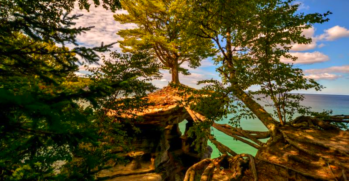
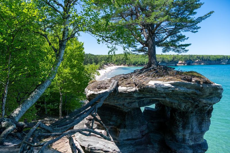
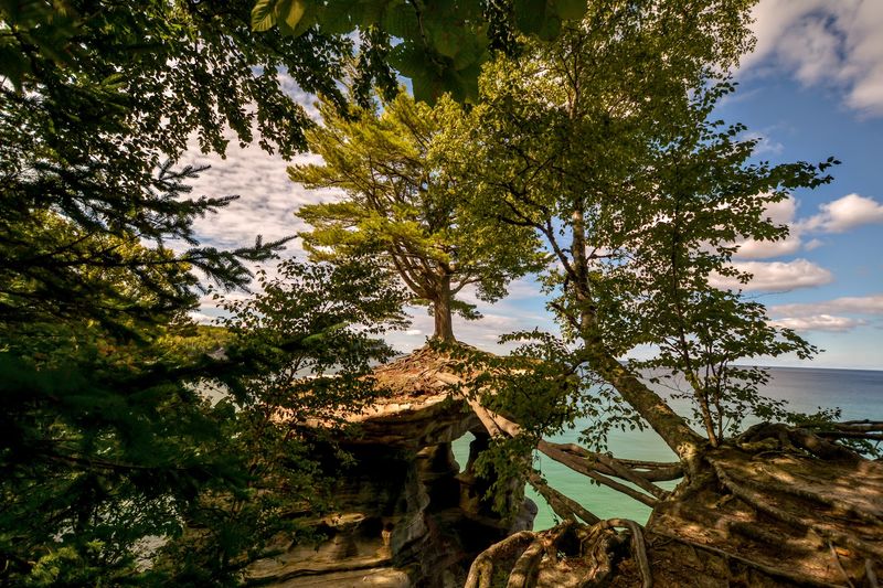
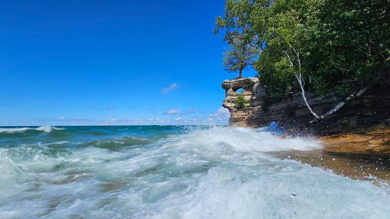
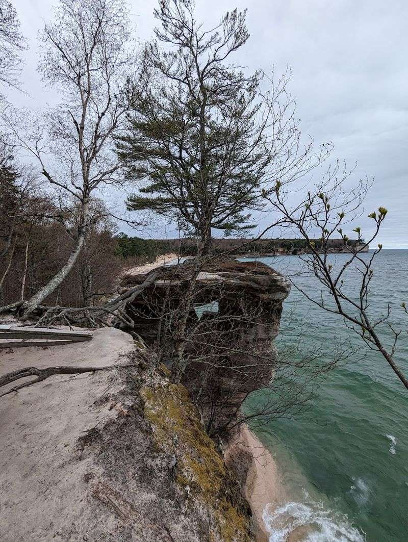
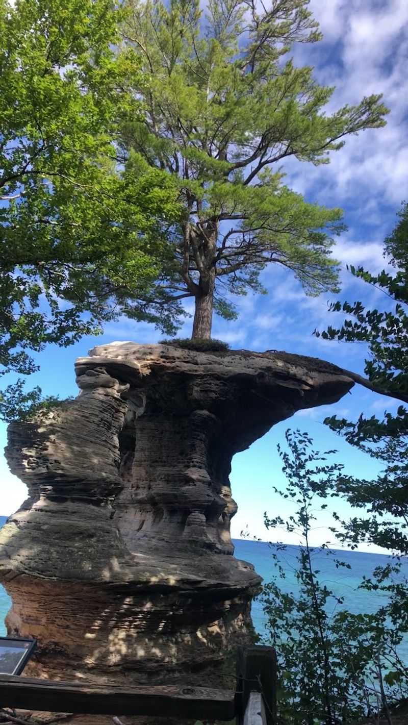
There is a sandstone pillar rising from the edge of Lake Superior that looks like it should not be standing at all. The arch that once connected it to the mainland collapsed long ago, and what remains is a dramatic column of rock with a white pine growing right on top, its roots stretching across a wide gap like nature’s own suspension bridge.
That tree, clinging to bare stone above crashing waves, tells a story about resilience that no photograph fully captures. Chapel Rock, tucked inside Pictured Rocks National Lakeshore in Munising Township, Michigan, earns every bit of its reputation as one of the Upper Peninsula’s most jaw-dropping sights.
Whether you hike the trail or cruise past it on Lake Superior, this ancient pillar will stop you mid-sentence. Read on to find out everything you need to know before you go, from the geology and the hike to the hidden beach waiting just around the corner.
Where Chapel Rock Actually Stands
Chapel Rock stands within Pictured Rocks National Lakeshore, located in Munising Township, Alger County, Michigan 49884, along the southern shoreline of Lake Superior in the Upper Peninsula of the United States.
The coordinates place it at roughly 46.5487 degrees north latitude, deep inside a federally protected stretch of coastline that runs for about 42 miles between Munising and Grand Marais.
The nearest town is Munising, which serves as the main gateway for visitors arriving by car. Most people reach the trailhead by taking H-58 and following signs toward Chapel Road, a gravel route that winds through the forest before reaching the parking area.
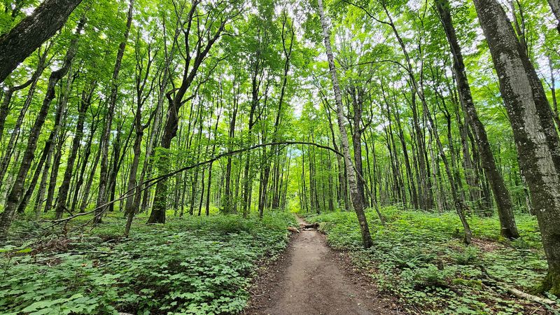
From that lot, Chapel Rock is approximately 3 miles on foot, making it a commitment worth planning for. The surrounding lakeshore park protects some of the most colorful and geologically fascinating cliffs in the entire Midwest, and Chapel Rock sits at the heart of that drama.
The Geology Behind the Pillar
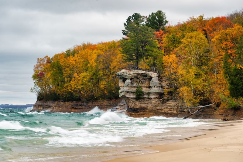
Chapel Rock is made of Munising Formation sandstone, a sedimentary rock laid down roughly 500 million years ago when a shallow sea covered this part of North America.
The sandstone is rich in iron oxide, which gives the cliffs their striking shades of red, orange, and rust that earned the entire park the name Pictured Rocks.
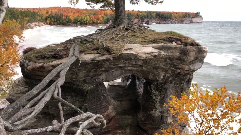
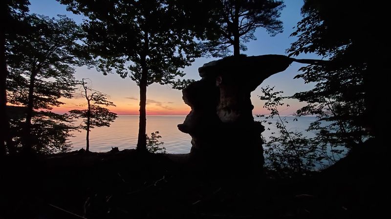
The arch that once connected the pillar to the mainland eroded away over thousands of years, carved by wave action, freeze-thaw cycles, and the relentless pressure of Superior’s storms. What remains is a freestanding column, roughly 60 feet tall, separated from the cliff by a gap that feels impossibly wide when you are standing at the edge looking down.
The sandstone is soft enough that erosion continues today, meaning the pillar’s shape is still slowly changing. Geologists consider Chapel Rock a classic example of how coastal rock formations evolve, making it as interesting scientifically as it is visually stunning.
The Pine Tree That Refuses to Quit
The white pine growing on top of Chapel Rock is arguably the most talked-about detail of the entire formation, and for good reason.
The tree’s roots have stretched across the open gap between the pillar and the mainland cliff, essentially bridging the two with a living root system that doubles as a natural anchor. Those roots, gnarled and exposed, are clearly visible from the trail and from the lake, and they give the scene an almost surreal quality.
The pine has survived up here because it established itself before the arch fully collapsed, and its roots grew outward as the gap widened beneath them. Today, the tree survives on thin soil and whatever nutrients the rock and rain can offer.
It is one of the most photographed trees in Michigan, and standing at the edge of the cliff looking at it, you start to understand why people describe this spot as feeling almost otherworldly. Nature, it turns out, is a stubborn architect.
Hiking the Chapel Loop Trail
The Chapel Loop Trail is the main hiking route that brings most visitors to Chapel Rock, and it rewards every step with something worth stopping for.
The full loop covers roughly 10 miles and passes Chapel Falls, Chapel Rock, Chapel Beach, and sections of Lake Superior shoreline that feel almost too beautiful to be real. A shorter out-and-back option covers about 6 miles round-trip and still includes the waterfall and the rock.
The trail is mostly flat with occasional rooted sections and a few steeper stretches near the falls. Hiking poles are genuinely useful here, especially when the trail is wet and muddy after rain, which it often is in spring and early summer.
Hikers should plan for about 1.5 to 3 hours depending on pace and how long they linger at each viewpoint. The parking lot at the trailhead fills up early on summer weekends, so arriving before 9 a.m. is a smart move that many visitors wish they had made sooner.
Chapel Falls Along the Way
About halfway to Chapel Rock on the trail, Chapel Falls appears through the trees like a curtain of white water dropping over a wide sandstone ledge.
The falls drop roughly 60 feet and spread out in a broad fan shape that is unusually wide for a Michigan waterfall, making it one of the more photogenic stops on the entire trail. A viewing platform gives you a clear sightline without needing to scramble down to the base.
The sound of the falls carries through the forest well before you see them, which builds anticipation in a very satisfying way. In late spring, the flow is strongest, fueled by snowmelt from the surrounding watershed.
By midsummer the volume drops, but the falls still flow steadily and the surrounding forest is lush and green. Chapel Falls is a natural rest point where most hikers pause, eat a snack, and remind themselves that the best part of the trail is still ahead, waiting just a few more miles down the path.
Seeing It From the Water
Not everyone who visits Chapel Rock does it on foot, and honestly, the view from the water might be the more dramatic of the two options.
Pictured Rocks Cruises, based out of Munising, runs boat tours along the lakeshore that pass directly in front of Chapel Rock, giving passengers a perspective that hikers simply cannot get from the trail. From the water, the full height of the pillar is visible, along with the colorful banded cliffs that stretch in both directions.
The boat tours run from late spring through early fall and typically last two to three hours, covering a wide stretch of the lakeshore that includes multiple named formations and cliff sections. Booking in advance is strongly recommended, especially in July and August when spots fill quickly.
Some visitors choose to do both the boat tour and the hike on separate days, and that combination gives a genuinely complete picture of this remarkable place. Two angles, one unforgettable formation.
Chapel Beach and the River Mouth
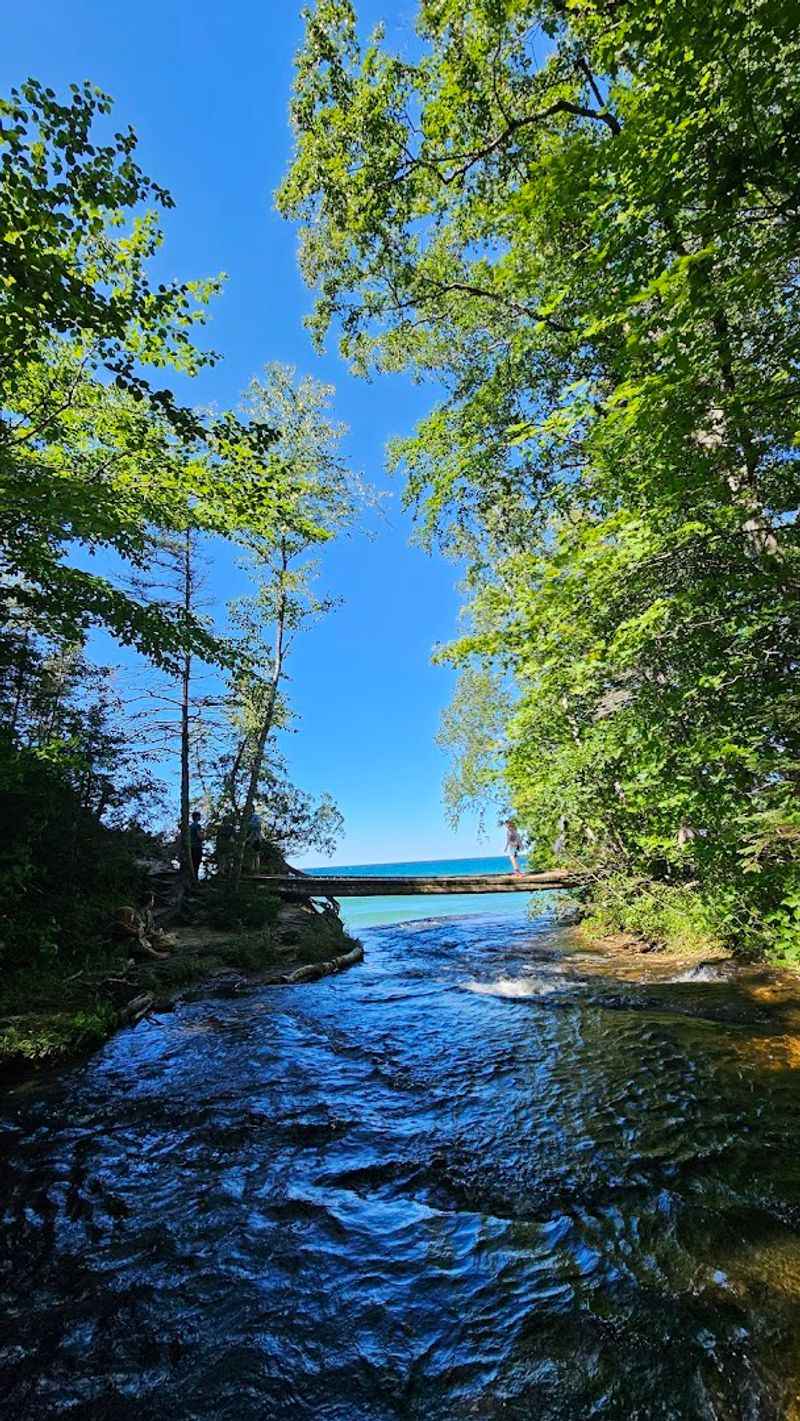
A short walk past Chapel Rock leads to Chapel Beach, a wide crescent of sand where the Chapel River meets Lake Superior in a scene that looks like it belongs somewhere far more tropical.
The water is clear and cold, the sand is soft and pale, and the river creates a shallow area near the mouth that is popular for wading. The beach is long enough that even on busy summer days it never feels truly crowded, partly because reaching it requires a real hike from the trailhead.
There is a backcountry campsite at Chapel Beach, managed by the National Park Service, where overnight visitors can wake up to the sound of waves and nothing else. A permit is required, and spots book up well in advance for summer weekends.
The combination of the beach, the river, and the rock formation just a few minutes away makes this one of the most complete natural experiences in the Upper Peninsula, worth every muddy mile of trail you cross to reach it.
Wildlife and Nature Along the Route
The forest between the Chapel trailhead and the lakeshore is alive with wildlife, and paying attention to the edges of the trail pays off regularly.
White-tailed deer are common sightings, especially in the early morning and evening hours. Bald eagles have been spotted riding thermals above the cliffs, and loons call from the lake in a sound that is unmistakably tied to the north woods.
Black bears live throughout the Upper Peninsula and have been reported in the Pictured Rocks area, so proper food storage at the campsite is not optional. Bear canisters or hanging food from a tree are both acceptable methods, and the park provides guidance at the trailhead.
Wildflowers line the trail in spring and early summer, including trillium, wild columbine, and various ferns that thrive in the moist, shaded understory. The bugs, however, are also very much alive, and anyone who skips the insect repellent in June or July will spend the hike regretting that particular decision.
Best Times to Visit Chapel Rock
Summer is the most popular season at Chapel Rock, with July and August drawing the largest crowds, but it is far from the only good time to visit.
Late June offers a sweet spot where the weather is warm, the wildflowers are still blooming, and the parking lot has not yet reached peak chaos. September and early October bring fall color that frames the red sandstone cliffs in shades of orange and gold, creating a color combination that photographs almost too well.
Winter access is limited and requires snowshoes or cross-country skis, as the road is not maintained past a certain point. The frozen lakeshore and icy formations are spectacular for those prepared to handle cold-weather conditions safely.
Spring visits are possible but come with the muddiest trail conditions of the year, so waterproof boots are not a suggestion but an actual requirement. Whatever season you choose, the formation itself does not change, and the lake has a way of making every visit feel like the first one.
Practical Tips Before You Go
A few practical details can make the difference between a smooth visit and a frustrating one, and Chapel Rock is remote enough that preparation actually matters here.
The Chapel Road trailhead parking lot is unpaved and fills up fast on summer weekends, often by 9 a.m. Arriving early or visiting on a weekday dramatically improves your chances of getting a spot without circling the lot.
Carry at least two liters of water per person, as there are no facilities on the trail beyond the backcountry campsite. Snacks are worth packing too, because the round-trip hike takes most people between three and five hours depending on stops.
Cell service is essentially nonexistent once you leave the parking area, so downloading an offline map before you go is a genuinely useful habit. The National Park Service also offers printed trail maps at the Munising visitor center, and picking one up costs nothing but saves a surprising amount of confusion once you are deep in the woods.


