Some of the most memorable mountain views in the United States were designed to be seen without breaking a sweat. Over the last century, roads, pullouts, and parkways turned scenic grandeur into public infrastructure, shaped by the CCC, the Park Service, and a rising car culture from the 1910s through the 1960s.
You are following a lineage of roadside sightseers who learned history through windshields, postcards, and family snapshots. Keep reading to trace how engineering, policy, and popular travel habits created a gallery of vistas you can reach with only a few steps.
1. Tunnel View – Yosemite National Park, California
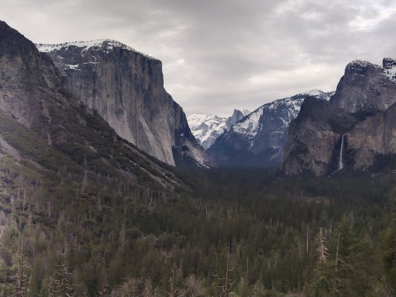
Your first glimpse feels curated by an engineer with an eye for postcards. Tunnel View owes its fame to the 1933 completion of the Wawona Tunnel, which deposited motorists into a cinematic reveal that photographers quickly canonized.
Ansel Adams amplified the angle in the 1930s and 1940s, fixing El Capitan, Bridalveil Fall, and Half Dome into a single public memory. The National Park Service formalized the overlook with masonry walls and pullouts that matched Mission 66 priorities for car-friendly visitation.
Tour buses, family sedans, and rental compacts kept the composition democratic, proving access could be both easy and iconic. Park planners balanced simplicity with protection, using defined viewing areas to keep trampling to a minimum while preserving the famous sightline.
You step from the car and step into history shaped by concrete, granite, and photography. The scene reminds you that American park design once measured success by how many people could see a view without a backpack.
2. Logan Pass – Glacier National Park, Montana
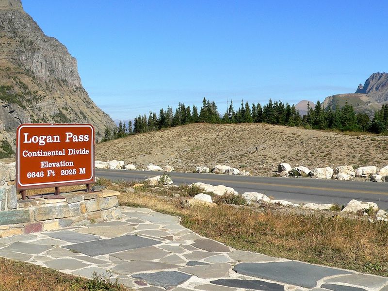
Momentum, not mileage, changed mountain tourism here. When Going-to-the-Sun Road opened in 1932, it stitched together switchbacks and stone guardrails so ordinary drivers could crest the Continental Divide.
Logan Pass became a living classroom where motorists learned the vocabulary of glaciers from a parking lot. Designers blended scenery and safety through signature rubble masonry and carefully placed pullouts that still shape your route choices.
CCC crews stabilized slopes and improved approaches during the 1930s, turning precarious tracks into reliable access. The Park Service layered in exhibits that interpreted ice, geology, and wildlife for people whose gear list only included a map and patience.
You can wander a short boardwalk or simply stand near the car as alpine meadows explain themselves. The view rewards minimal effort because a generation of planners treated accessibility as a public good, not an afterthought.
3. Artist Point – North Cascades National Park, Washington
Creativity found a parking space at the end of a road. Artist Point crowns the Mount Baker Highway, a 1930s route whose seasonal plowing turned alpine panoramas into routine weekend plans.
By the postwar years, family cars joined painters and photographers capturing Mount Shuksan as if it were a studio backdrop. The highway’s terminus signaled a New Deal legacy where access served both recreation and regional identity.
Interpretive panels teach geology and glaciation without demanding trail mileage, a nod to inclusive design updated over decades. Even the snowbanks tell a policy story, as transportation crews battle drifts so summer tourists can claim a five-minute walk view.
You are part of that ritual when you park, pivot, and frame a scene already famous from calendars. The overlook proves that infrastructure can invite creativity without requiring an expedition.
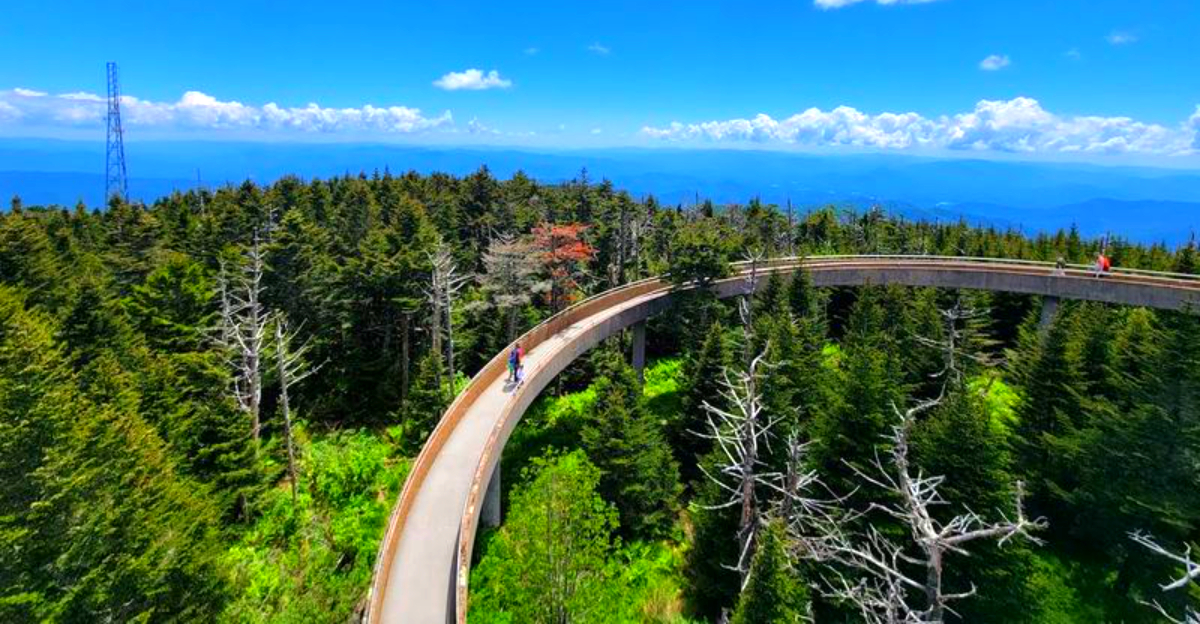
4. Clingmans Dome Road Overlook – Great Smoky Mountains, Tennessee/North Carolina
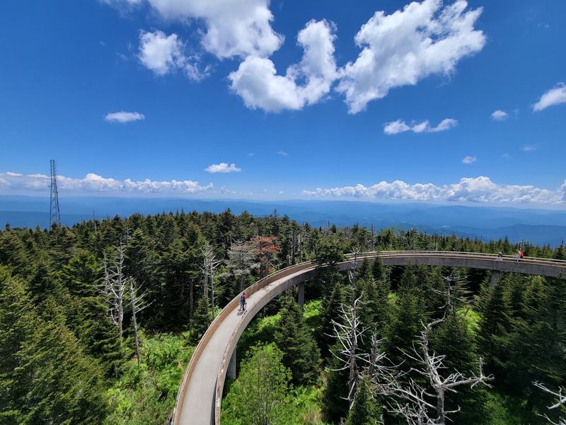
This is where Appalachia met modern mobility. Clingmans Dome Road, developed in the 1930s and refined through Mission 66, carried families from valley towns to ridgelines once reached mostly by footpaths and logging grades.
The 1960 observation tower symbolized a rising belief that broad horizons should be easy to share. Pullouts below the tower offer quick-stop panoramas that echo the era’s design language of ramps, curves, and concrete.
CCC labor shaped grades, drainage, and walls that still manage weather and traffic. Interpretive signs translate forest recovery and park history for visitors who budget minutes, not miles.
You can sample the Smokies’ broad geography without committing to a summit hike. Many travelers pause here before continuing to the tower trail, using the overlook as their first introduction to the high-elevation landscape.
Seasonal changes in visibility and foliage keep the viewpoint relevant across different times of year.
The overlook proves that civic investment and simple parking can democratize big views.
5. Bear Lake Overlook – Rocky Mountain National Park, Colorado
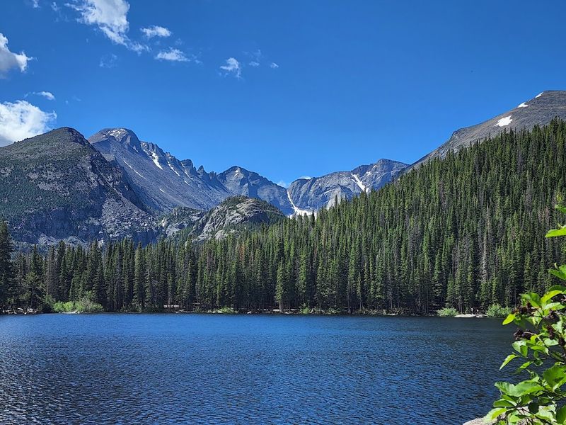
Convenience earned tenure beside this alpine water. Bear Lake Road, built between 1928 and 1939 with CCC craftsmanship, delivered drivers to a compact amphitheater of spruce, granite, and classic Front Range silhouettes.
Later reconstructions improved shoulders and walls so crowds could arrive, step out, and understand why early boosters marketed Rocky Mountain scenery to rail passengers. Today’s managed access and short walks keep the experience calm without demanding trail miles.
Interpretive panels explain glacial carving and tourism patterns that shifted from rail to automobile by midcentury. The setting doubles as a memory lab where family snapshots created a vernacular archive of American vacations.
You stroll a few steps and see the long arc of park planning in one glance. The overlook continues to prove that short approaches can deliver big context.
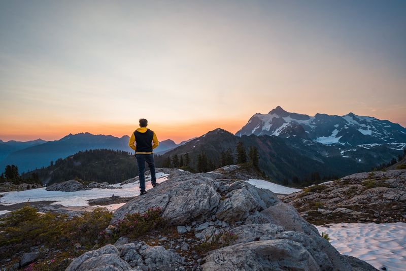
6. Hurricane Ridge – Olympic National Park, Washington
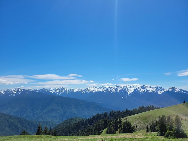
Ease of access turned this crest into a household name for Northwest road trippers. The Hurricane Ridge Road reached its high viewpoints by the late 1950s, aligning with Mission 66 goals that foregrounded windshield education.
Short walks from the parking lot supply a syllabus on glaciation and rain-shadow ecology. The design choice to place learning within reach reflected postwar optimism about cars as tools for public land literacy.
Winter recreation once shared space with summer sightseeing, knitting the ridge into regional traditions. Wayfinding signs and low walls channel foot traffic so fragile meadows survive heavy use.
You stand by a railing and read the mountains like a chart. The scene tells how a coastal park embraced access while teaching restraint.
7. Mount Washington Auto Road Summit – New Hampshire
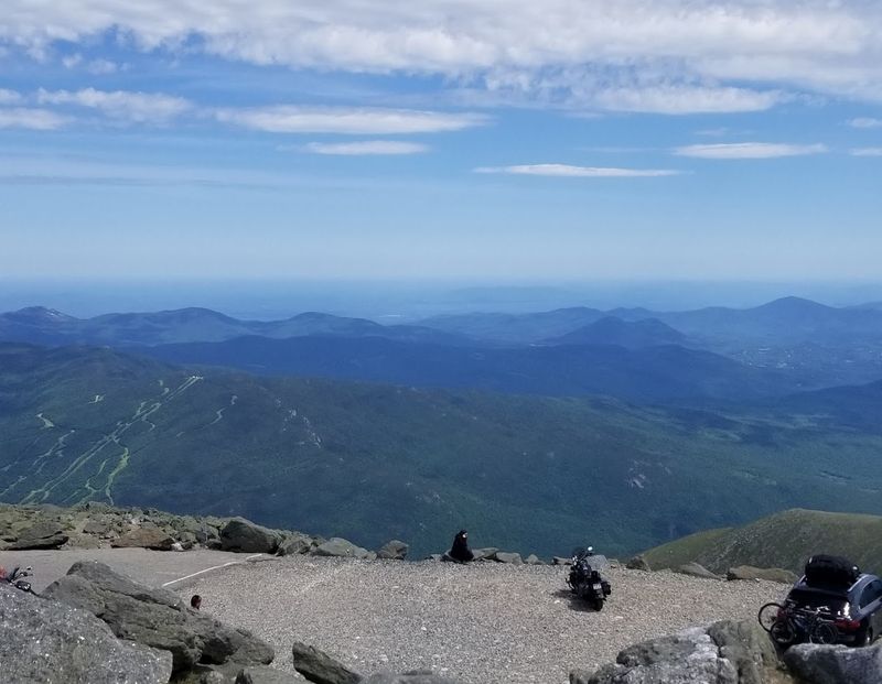
Ambition reached the clouds here long before tailpipes. The Mount Washington Carriage Road opened in 1861, proving that a toll road could convert peak fever into enterprise and education.
The motor age only expanded the audience, preserving the climb’s business model while rewriting the soundtrack. By midcentury, dashboard travelers joined railroad and hotel guests in sharing a four-state horizon.
Summit buildings, weather records, and interpretive displays turn a short walk from the car into civics and science. Guardrails, grade signs, and pullouts narrate the evolution of safety from horses to horsepower.
You top out, park, and collect stories older than most highways in America. The Auto Road shows how private and public interests together built access that still feels audacious and practical.
8. Dante’s View – Death Valley National Park, California
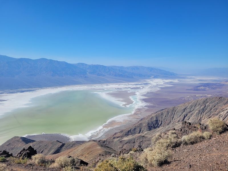
Perspective became a product on this ridge. In the 1920s, borax marketing and automobile clubs helped popularize panoramic stops that gave motorists an instant grasp of Death Valley’s scale.
Dante’s View fit the blueprint perfectly once roads improved and the monument designation arrived in 1933. By the 1950s, postcards and guidebooks sold the view as a quick detour that required more curiosity than cardio.
Simple railings, paved approaches, and wayfinding ensured the scene stayed accessible and durable. Interpretive signs connect the dots between valley salt flats, mining promotions, and the federal upgrade to national park status in 1994.
You park, look down, and read a century of desert storytelling in one sweep. The overlook demonstrates how a clear vantage can turn geology into an easy lesson.
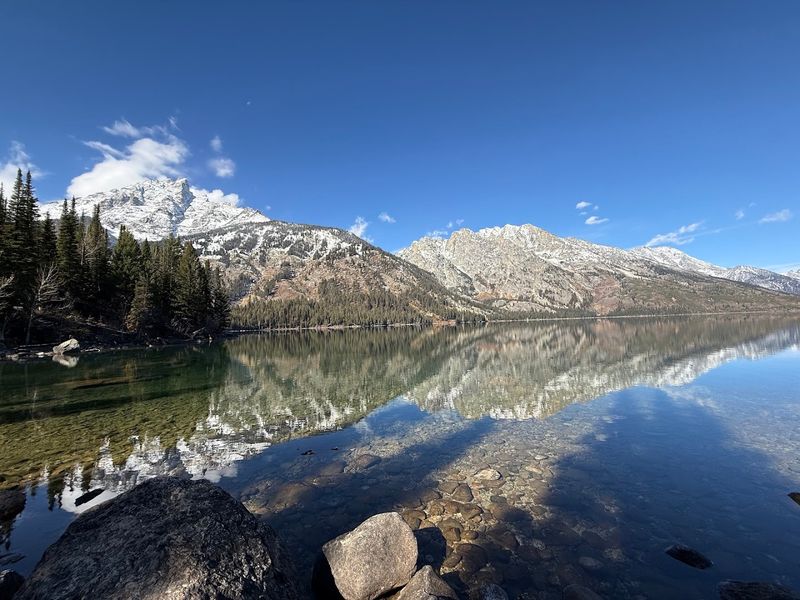
9. Snake River Overlook – Grand Teton National Park, Wyoming
One frame here helped sell an idea to a nation. Ansel Adams photographed the Snake River in 1942 for a Department of the Interior project that aligned beauty with conservation policy.
The overlook later absorbed that legacy into everyday sightseeing, offering the same curve and peaks to families on a quick stop. Modest improvements kept foot traffic predictable while protecting riverbank vegetation below.
Interpretive panels explain the photo’s context within wartime documentation and emerging park ideals. Drivers today repeat the composition with digital ease, extending an eighty-year conversation about access and preservation.
You step out, align the horizon, and participate in civic imagery. The view proves that policy can ride along with a roadside panorama.
10. Cedar Breaks Scenic Overlook – Utah
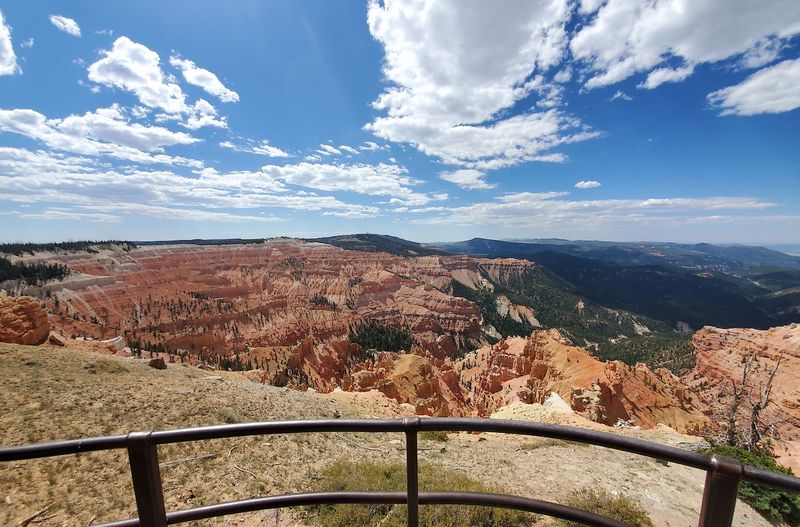
Public works carved a path to spectacle on this high rim. Cedar Breaks became a national monument in 1933, and CCC crews soon stacked stone, graded roads, and framed viewpoints that still define the visit.
The amphitheater’s banded cliffs look textbook-ready from a parking pullout, which was exactly the point. Depression-era planners wanted geology lessons to start beside a fender, not at the end of a slog.
Interpretive signs credit the workers and explain plateau uplift in plain language. Seasonal access and short strolls reflect a management style that balances elevation, snow, and demand.
You rest an elbow on CCC masonry and read time in color. The overlook continues to teach because design made learning easy to reach.
11. Inspiration Point – Grand Teton National Park, Wyoming
Efficiency turned this viewpoint into a classic itinerary. A scenic boat ride across Jenny Lake, popular since early concession operations, cuts the approach to a brisk walk that rewards even a tight schedule.
Park managers shaped docks, trail steps, and signs so more visitors could taste rugged scenery without committing to a big ascent. The setup mirrors midcentury strategies that used concessions and light infrastructure to open alpine drama to casual travelers.
Interpretive materials tie glacial lakes to the park’s creation story and evolving visitor services. The proximity of big peaks to easy access has long made the Tetons a laboratory for balancing scenery with stewardship.
You arrive quickly, look up, and understand why short routes can carry heavy meaning. The point confirms that smart logistics can multiply awe without adding miles.
12. Sylvan Lake Shoreline – Custer State Park, South Dakota
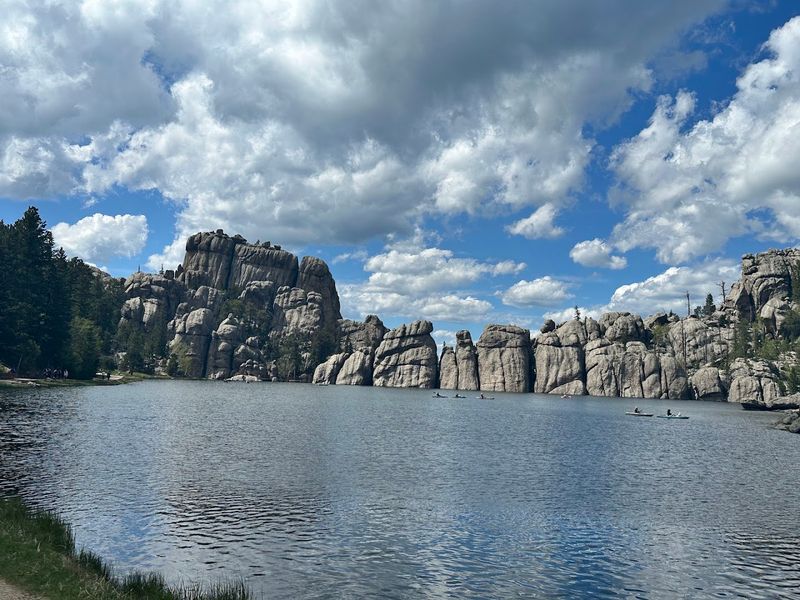
Sometimes a view is engineered right into existence. Sylvan Lake appeared in 1891 when Theodore Reder built a dam, creating a mirror for Black Hills spires that tourists could enjoy with a few steps from the car.
By the 1910s and 1920s, motor routes and park promotion turned the shoreline into a picnic and photo ritual. Later improvements refined paths and guardrails, keeping the stroll short and the scenery dependable.
Historical markers explain the dam’s role and the park’s growth as automotive tourism replaced rail excursions elsewhere. The blend of human alteration and granite drama became part of the region’s identity and summer routines.
You circle a small section and gather a century of visitor habits in minutes. Climbers trace routes along nearby granite formations while families follow the lakeside trail that loops around the water.
Even a short stop reveals how the lake became one of the Black Hills’ most photographed gathering spots.
The shoreline proves that convenience and history can share the same frame.


