Volcanoes are some of the most powerful and awe-inspiring forces on Earth, and the United States has plenty of them to explore. From the fiery lava flows of Hawaii to the blast-scarred landscapes of Washington State, volcanic wonders stretch across the country.
Whether you are an adventure seeker, a science enthusiast, or just someone who loves jaw-dropping scenery, there is a volcano tour out there with your name on it. Strap on your hiking boots and get ready to experience geology like never before.
Hawaiʻi Volcanoes National Park Lava Tour — Hawaii
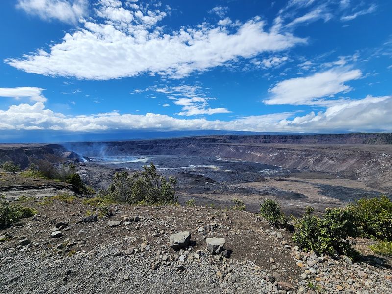
Nothing quite prepares you for standing on ground that was once flowing, molten rock. The Hawaiʻi Volcanoes National Park Lava Tour is one of the most dramatic geological experiences anywhere in the country.
Expert guides walk visitors through vast lava fields, past hissing steam vents, and along the rim of the massive Halemaʻumaʻu crater inside Kīlauea volcano.
Evening tours are especially popular because the glow from active lava can sometimes be spotted after dark, turning the whole experience into something almost otherworldly. Guides do a brilliant job of mixing hard science with Hawaiian cultural traditions, giving visitors a deeper understanding of why these landscapes hold sacred meaning for Native Hawaiians.
The park itself covers over 330,000 acres, so there is always something new to discover no matter how many times you visit. Comfortable walking shoes are a must, and layers are recommended since temperatures near the crater can shift quickly.
Whether you are eight years old or eighty, this tour delivers memories that genuinely last a lifetime. Book early because spots fill up fast, especially during active eruption periods.
Kīlauea Helicopter Volcano Flight — Hawaii
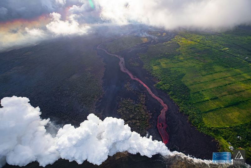
Buckle up, because this might be the most breathtaking 45 minutes of your life. Helicopter tours over Kīlauea give passengers a bird’s-eye view of one of the world’s most continuously active volcanoes.
From above, you can truly grasp the sheer scale of lava flows that have reshaped entire coastlines over centuries.
Pilots double as knowledgeable guides, pointing out fresh lava channels, collapsed lava tubes, steaming fissures, and the brilliant contrast between jet-black rock and emerald rainforest below. On clear days, waterfalls tumbling down the island’s dramatic cliffs add extra scenery to an already stunning flight path.
Fun fact: Kīlauea has been erupting almost continuously since 1983, making it one of the most active volcanoes on the planet. Passengers sit in large windows that offer unobstructed panoramic views, and many tours provide noise-canceling headsets so guides can narrate throughout the flight.
Camera batteries should be fully charged before takeoff because you will not stop shooting photos the entire time. Children typically need to be a minimum height to participate, so check requirements when booking your flight.
Haleakalā Summit Sunrise Tour — Maui, Hawaii
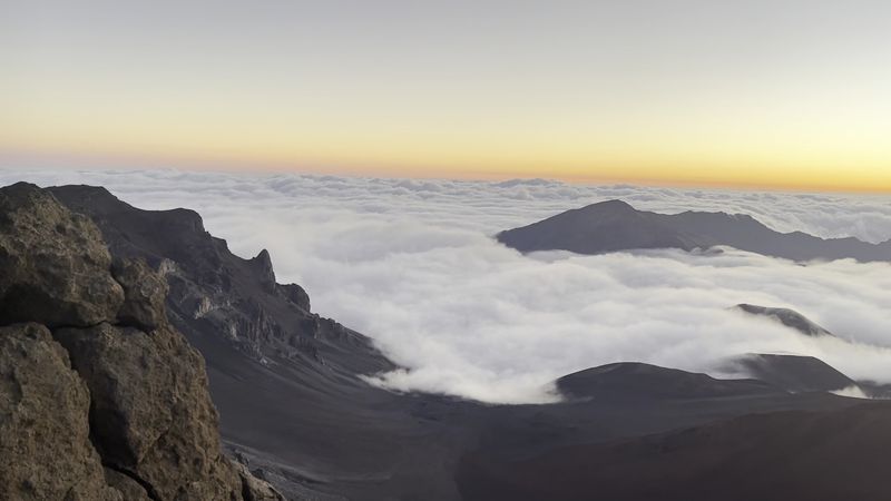
Set your alarm for something truly spectacular. Standing at the summit of Haleakalā at sunrise, more than 10,000 feet above sea level, feels like watching the world wake up from the edge of the universe.
The volcano’s massive crater stretches out below you in shades of rust, gray, and deep purple while clouds drift silently beneath your feet.
Guided sunrise tours typically depart in the early morning hours, well before dawn, to reach the summit in time for the show. Many tours include informative stops along the way, covering Haleakalā’s volcanic geology and the rich Hawaiian mythology tied to this sacred mountain.
According to legend, the demigod Maui lassoed the sun right here to slow it down and give the island more daylight.
After sunrise, some tours wind back down through charming upcountry Maui towns where local farms and lavender fields make for a surprisingly sweet contrast to the stark volcanic summit. Temperatures at the top can drop well below 40 degrees Fahrenheit even in summer, so bring a warm jacket regardless of what the weather is doing at sea level.
Reservations for summit access are required well in advance.
Mount St. Helens Blast Zone Tour — Washington
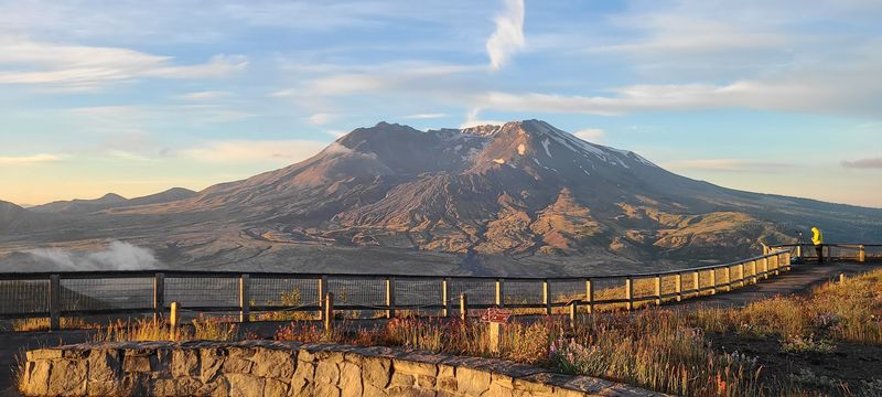
On May 18, 1980, Mount St. Helens unleashed a lateral blast so powerful it flattened 230 square miles of forest in minutes. Today, guided Blast Zone Tours bring visitors face to face with a landscape that still tells that violent story loud and clear.
Johnston Ridge Observatory sits just five miles from the crater and offers one of the most dramatic volcanic viewpoints in North America.
Knowledgeable guides explain exactly what happened that morning, walking visitors through the sequence of events from the initial earthquake to the massive pyroclastic surge that reshaped the entire northern face of the mountain. The science is fascinating, but the emotional weight of standing in that landscape makes it hit differently than any textbook ever could.
What surprises most visitors is how much life has returned since 1980. Elk herds roam the recovering meadows, wildflowers push through volcanic ash, and young trees have reclaimed sections of the old blast zone.
Nature’s resilience here is genuinely moving. Guided hikes through lava fields and into old-growth forest remnants add extra depth to the experience.
Sturdy hiking boots and sunscreen are highly recommended for outdoor portions of the tour.
Ape Cave Lava Tube Adventure — Washington
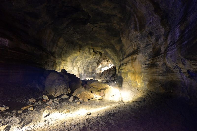
Squeeze through a tunnel carved entirely by ancient lava and you start to understand just how creative geology can be. Ape Cave, located near Mount St. Helens, stretches nearly 13,000 feet underground, making it one of the longest continuous lava tubes in North America.
It formed roughly 2,000 years ago when the outer shell of a lava flow hardened while molten rock drained out from the inside, leaving a hollow passageway behind.
Guided tours are available for both the lower and upper sections of the cave, with the upper route being significantly more challenging and adventurous. Low ceilings, lava falls, and tight squeezes make the upper cave feel like a real underground expedition.
Guides provide lanterns, explain the geological processes that created the tube, and point out fascinating features like lava ball formations and ancient lava benches along the walls.
The cave maintains a constant temperature of around 42 degrees Fahrenheit year-round, so warm clothing is essential even during hot summer months. Wearing layers and bringing extra light sources is strongly recommended.
Kids who love a good adventure tend to absolutely lose their minds over this place in the best possible way. Arrive early on weekends to avoid long entry lines.
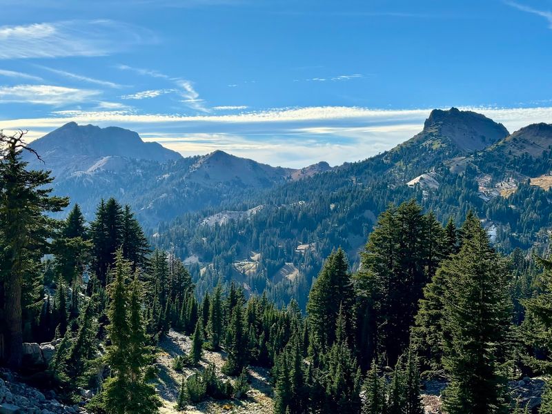
Lassen Peak Volcano Hike — California
Lassen Peak last erupted in 1915, sending a mushroom cloud of ash seven miles into the sky and reminding everyone in Northern California that the ground beneath their feet is very much alive. Today, guided hikes to the 10,457-foot summit reveal a volcanic landscape packed with geological variety that is almost unmatched anywhere in the world.
Lassen Volcanic National Park is one of only a handful of places on Earth where all four volcano types — plug dome, shield, cinder cone, and composite — can be found within a single park boundary. The hike to Lassen Peak itself covers about five miles round trip with a 2,000-foot elevation gain, so a reasonable level of fitness is helpful.
Guides point out steaming fumaroles, ancient lava domes, and snow-filled craters along the route.
Views from the summit on a clear day stretch across Northern California and into Nevada, rewarding every step of the climb. Wildflower meadows and high-alpine lakes dotting the park below add color to an otherwise stark volcanic palette.
The hiking season typically runs from July through October when snow has cleared the trail. Bring plenty of water and snacks because the thin mountain air works up an appetite faster than you might expect.
Bumpass Hell Geothermal Tour — California
The name alone is enough to make you curious. Bumpass Hell, named after a 19th-century explorer who burned his leg after breaking through the thin crust above a boiling pool, is the largest hydrothermal area in Lassen Volcanic National Park.
Guided tours here feel like stepping onto a different planet entirely.
Boardwalks wind through an active landscape of bubbling mud pots, hissing steam vents, and vivid pools tinted yellow, orange, and green by sulfur-loving microorganisms called thermophiles. Guides explain the geothermal system powering all this activity, connecting it to the magma chamber still sitting beneath Lassen Peak.
The science is wild, the smells are memorable, and the colors are absolutely electric.
Water temperatures in some pools exceed 200 degrees Fahrenheit, so staying on the boardwalks is non-negotiable for safety reasons. The round-trip trail from the trailhead covers about three miles with moderate elevation changes, making it accessible for most fitness levels.
Early morning tours often feature more steam rising from the vents as cooler air meets the superheated ground, creating dramatic visual effects. Sunscreen, sturdy shoes, and a genuine sense of wonder are the only gear requirements for an unforgettable geothermal adventure.
Crater Lake Volcano Rim Tour — Oregon
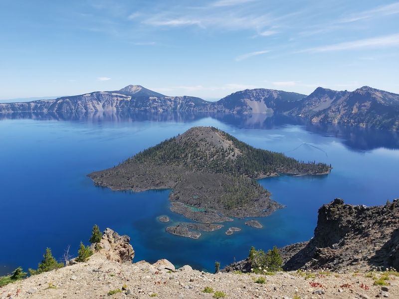
Crater Lake is so impossibly blue that first-time visitors often wonder if someone added food coloring. The color comes from the lake’s extraordinary depth — at 1,943 feet, it is the deepest lake in the United States — and the remarkable clarity of its water.
But the real story here is geological, and guided rim tours tell it beautifully.
Around 7,700 years ago, a massive volcano called Mount Mazama erupted with such violence that it essentially blew its own top off. The peak collapsed inward, forming a giant caldera that gradually filled with rainwater and snowmelt over thousands of years.
Guided rim tours circle the caldera’s edge, stopping at viewpoints that reveal the full dramatic sweep of the lake and its resident volcanic island, Wizard Island.
Guides cover everything from the eruption sequence to the Native Klamath people who witnessed the event and passed down accounts through oral tradition for generations. Boat tours to Wizard Island are available separately and offer an entirely different perspective from the water’s surface.
The rim road reaches elevations above 8,000 feet, so temperatures can drop sharply even in midsummer. A light jacket tucked into your daypack will save you from an unexpected chill at the most scenic overlooks.
Newberry National Volcanic Monument Lava Lands Tour — Oregon
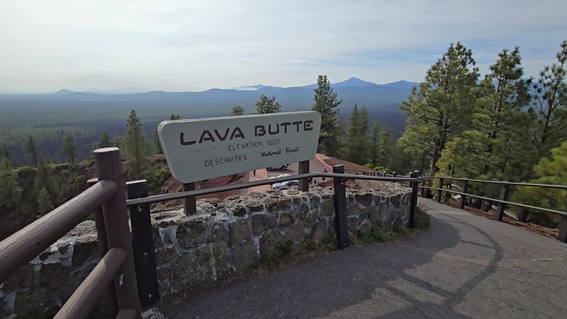
Oregon does not get nearly enough credit for its volcanic drama, and Newberry National Volcanic Monument is proof. Centered on the massive Newberry Volcano — a shield volcano stretching more than 1,200 square miles — this monument packs an astonishing variety of volcanic features into one spectacular destination.
Guided Lava Lands Tours make sure visitors do not miss any of them.
Lava Butte, a perfectly formed cinder cone rising 500 feet above the surrounding lava plain, is one of the tour highlights. A paved road spirals to the summit where panoramic views stretch across Central Oregon, revealing just how far ancient lava flows traveled across the landscape.
From there, guides often lead groups into the Lava River Cave, a 5,211-foot lava tube that rivals Ape Cave in atmosphere and geological interest.
Newberry Volcano last erupted just 1,300 years ago, which is essentially yesterday in geological terms. The lava fields it left behind still look raw and jagged, as if the rock barely had time to cool.
Guided tours also visit obsidian flows on the volcano’s summit caldera, where shiny volcanic glass catches the light in spectacular fashion. The monument sits just south of Bend, Oregon, making it an easy addition to any Central Oregon road trip itinerary.
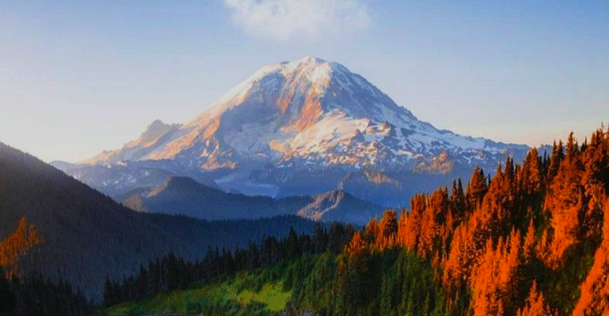
Mount Rainier Volcano Exploration Tour — Washington
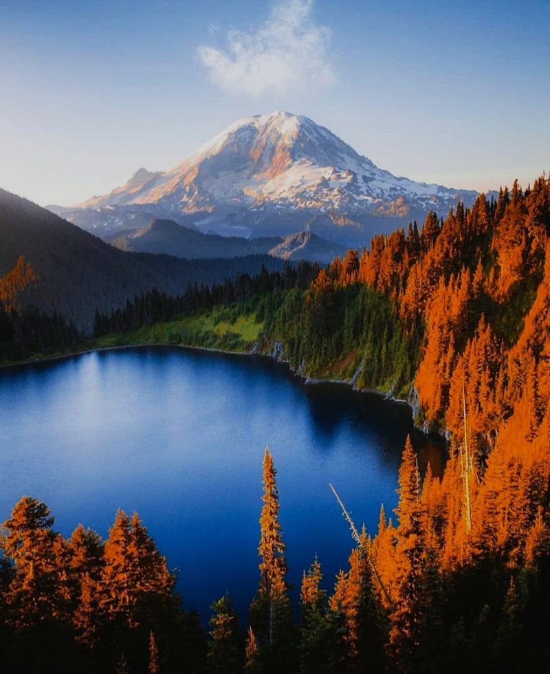
At 14,411 feet, Mount Rainier dominates the skyline of western Washington so completely that residents from Seattle can see it on clear days from over 60 miles away. It is the most heavily glaciated peak in the lower 48 states, draped in more than 25 named glaciers that collectively hold more ice than all other Cascade volcanoes combined.
Guided exploration tours reveal both its alpine beauty and its volcanic personality.
Rangers and guides discuss the mountain’s classification as one of the world’s most dangerous volcanoes due to the enormous volume of ice that could trigger catastrophic lahars — volcanic mudflows — if a future eruption occurred. That information sounds alarming but is delivered in a way that deepens appreciation for the mountain rather than causing panic.
The geology lessons feel genuinely exciting out here.
Tour stops include Paradise, one of the snowiest places on Earth, where wildflower meadows explode with color in late summer. Sunrise Visitor Center offers the highest point reachable by car in Washington, with jaw-dropping views across the volcanic Cascades.
Guides point out fumaroles near the summit crater that remind visitors Rainier is not dormant — just resting. Layered clothing and waterproof footwear handle the unpredictable mountain weather with ease.
Sunset Crater Volcano Guided Walk — Arizona
Picture waking up one morning around the year 1085 to find a brand-new volcano erupting in your backyard. That is exactly what happened to the Sinagua people living near what is now Sunset Crater Volcano National Monument in northern Arizona.
The eruption reshaped the landscape and scattered volcanic ash across hundreds of square miles, forcing communities to relocate entirely.
Guided walks through the monument bring this ancient story to life in compelling fashion. The Lava Flow Trail winds through fields of jagged black basalt and past dramatic squeeze-ups — blobs of lava that were pushed upward through cracks as the flow cooled.
The crater itself glows with rust-red and orange cinder deposits near its rim, which is how it earned such an evocative name.
Guides connect the geological events to the human history of the region, explaining how the eruption ultimately affected trade routes and settlement patterns across the prehistoric Southwest. The monument sits at about 7,000 feet elevation, so summer temperatures are far more comfortable than the scorching desert heat found at lower Arizona elevations.
Sunset lighting on the cinder cone creates photography conditions that landscape photographers specifically plan trips around. Sturdy closed-toe shoes handle the sharp lava rock surfaces much better than sandals.
Mount Shasta Volcano Climbing Tour — California
Mount Shasta rises so suddenly and dramatically from the flat valley floor of Northern California that early explorers thought they were hallucinating. At 14,179 feet, this massive stratovolcano is visible from over 100 miles away on clear days and has inspired legends, spiritual seekers, and serious mountaineers for generations.
Guided climbing tours make the summit accessible to fit beginners willing to put in real effort.
The standard Avalanche Gulch route involves crampons, ice axes, and a very early pre-dawn start to reach the summit before afternoon weather rolls in. Guides manage rope teams, teach basic crampon technique, and monitor conditions on the mountain’s notoriously unpredictable slopes.
The volcanic geology along the route is fascinating, with fumaroles near the summit crater releasing sulfurous steam even in the dead of winter.
Shasta’s last confirmed eruption occurred around 1786, and scientists consider it a high-threat volcano that could erupt again in the future. That geological context gives every step of the climb an added layer of meaning.
Summit success rates vary depending on weather and snow conditions, but even turning back early offers views that most people never get to experience. Multi-day guided expeditions include camping on the mountain, which adds a star-gazing bonus that is genuinely hard to beat.
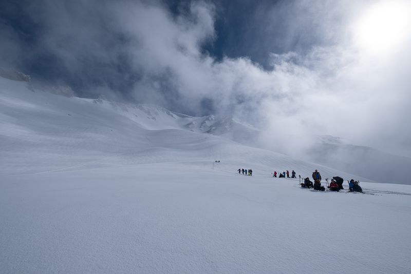
Mauna Loa Volcano Hiking Tour — Hawaii
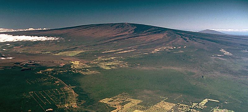
By volume, Mauna Loa is the largest volcano on Earth — full stop. It contains roughly 18,000 cubic miles of rock, built up layer by layer over hundreds of thousands of years of eruptions.
Most of the mountain sits below sea level, but what rises above the ocean surface is still tall enough to affect weather patterns across the entire Big Island of Hawaii.
Guided hiking tours across Mauna Loa’s summit and rift zones take visitors through some of the most remote and geologically raw terrain in the Hawaiian Islands. Vast lava fields stretch in every direction, broken occasionally by cinder cones and pit craters that remind hikers just how dynamic this landscape remains.
Mauna Loa erupted as recently as November 2022, making it one of the freshest volcanic landscapes accessible on foot anywhere in the world.
The trails are long, exposed, and require solid physical preparation. High elevation means thinner air, intense UV radiation, and rapid weather changes that demand proper gear.
Guides carry emergency supplies and communicate with park rangers throughout the hike. The payoff for all that effort is standing on a landscape so otherworldly and geologically significant that it genuinely reframes how you think about the planet you live on.
Water and sun protection are non-negotiable essentials.
Valles Caldera National Preserve Tour — New Mexico
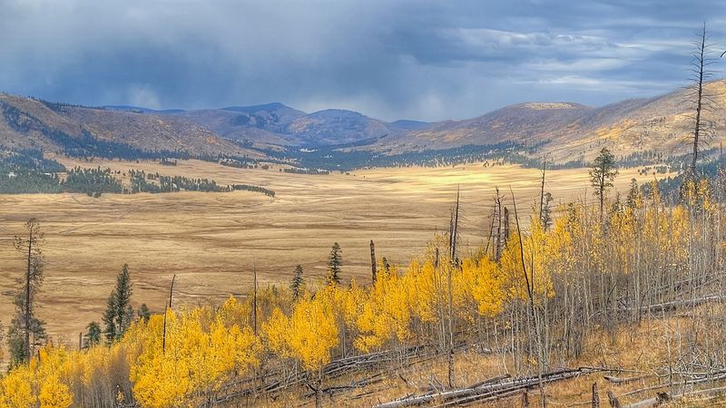
About 1.25 million years ago, a super-eruption so massive it dwarfed anything in recorded human history blasted a crater nearly 13 miles wide into the mountains of northern New Mexico. Today, that ancient volcanic scar is one of the most scenic and serene landscapes in the entire Southwest.
Valles Caldera National Preserve feels more like a painting than a real place on first glance.
Guided tours explore the caldera’s grassy valle grande — a sprawling meadow that fills the volcanic depression — where herds of elk graze with zero concern for the tourists watching them. Geothermal springs bubble quietly along stream banks, reminding visitors that volcanic heat still simmers beneath the surface.
Guides explain the eruption sequence, the caldera’s formation, and the long history of ranching and scientific research that took place within its boundaries.
The preserve sits at roughly 8,500 feet elevation, giving it a cool, high-altitude climate even in summer and brilliant golden aspen foliage in autumn. Photography opportunities here are extraordinary in every season.
Ranger-led programs cover geology, ecology, and the preserve’s cultural history going back thousands of years. Tour sizes are kept deliberately small to protect the landscape and maintain the sense of peaceful remoteness that makes Valles Caldera such a special destination.
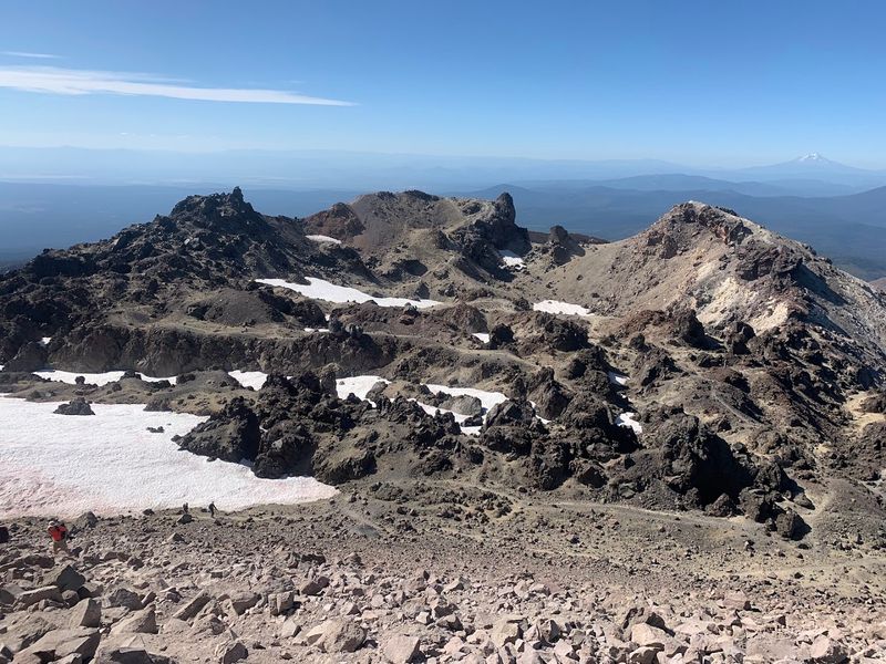
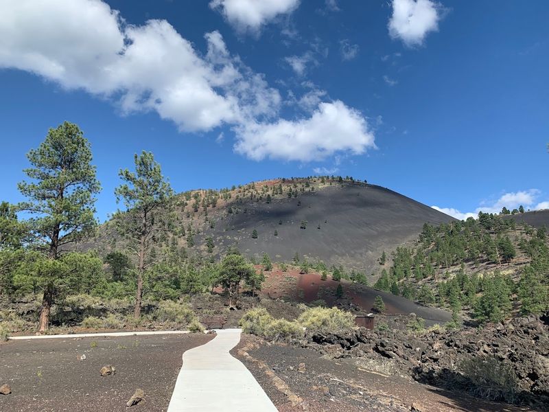
Cinder Cone Volcano Hike — California
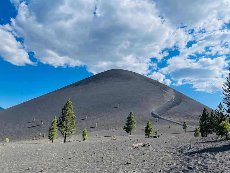
Climbing a cinder cone feels like hiking up a giant pile of volcanic gravel — because that is exactly what it is. Cinder Cone in Lassen Volcanic National Park last erupted around 1666, and the loose black and red cinders covering its steep flanks have barely changed since then.
Every step up the slope slides back just a little, making the summit feel like it is teasing you the whole way.
Guided hikes tackle the 700-foot climb to the summit rim, where a perfectly circular crater waits at the top. The view from the rim is genuinely stunning — the Painted Dunes spread below in vivid shades of orange, yellow, and red created by oxidized volcanic ash, while Snag Lake and the surrounding pine forests create a dramatic backdrop that photographers go absolutely wild for.
The round-trip hike covers about four miles total, with the steep summit section being the most physically demanding stretch. Guides explain how cinder cones form rapidly from a single eruptive event, making them geologically distinct from the larger composite volcanoes nearby.
The loose cinder makes the descent surprisingly fast and even a little fun if you let yourself slide down controlled. Gaiters or high-top shoes keep the fine volcanic material out of your socks during the climb.


