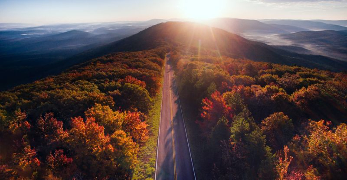
There is a road in southeastern Oklahoma that does not just take you somewhere, it shows you something. Winding high along the ridgelines of the Ouachita Mountains, this 54-mile route unrolls one sweeping view after another, and most people who drive it once end up planning a second trip before they even get home.
The elevation changes, the curves, the way the sky opens up at each overlook, it all adds up to a driving experience that feels genuinely special. From the fiery colors of late autumn to the deep green canopy of summer, this byway earns its reputation in every season.
Where the Journey Begins: Talihina, Oklahoma

The official address of the Talimena National Scenic Byway is OK-1 Scenic, Talihina, OK 74571, and that is exactly where the adventure kicks off. Talihina sits in the heart of southeastern Oklahoma, a small town that serves as the western gateway to one of the most celebrated scenic drives in the entire region.
From here, the road climbs steadily into the Ouachita Mountains, and within just a few miles, the landscape shifts in a way that catches first-time visitors completely off guard. The town itself is modest and quiet, but it carries a certain energy that comes from being the front door to something extraordinary.
Filling up your gas tank before you leave Talihina is a smart move, because there are no fuel stops along the mountain route. Packing snacks is equally wise, since food vendors are not available on the byway itself.
The drive runs 54 miles east through Oklahoma and into Mena, Arkansas, and every mile of it rewards the patience it takes to get there.
The Ouachita Mountains Setting

Not many people associate Oklahoma with mountain scenery, but the Ouachita Mountains quietly challenge that assumption every single day. The byway rides along the spine of the Rich Mountain and Winding Stair Mountain ranges, two of the highest ridgelines in the state, reaching elevations above 2,600 feet in some sections.
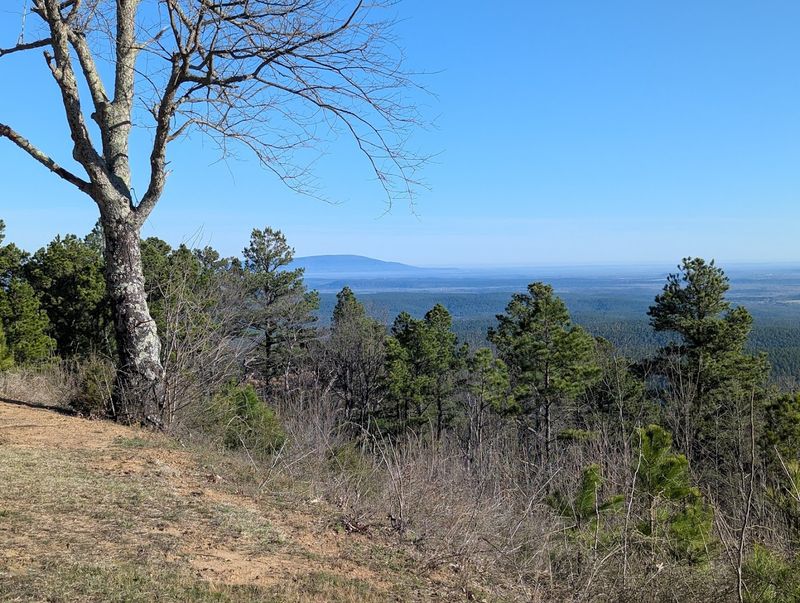
The terrain here is rugged in a way that feels ancient. Dense hardwood and pine forests cover the slopes, and when you look out from an overlook, the ridgelines stack up in layers of blue and green that seem to go on forever.
The scale of it is genuinely surprising for a state that most outsiders picture as flat.
The Ouachita National Forest surrounds much of the byway, and that federal protection has kept the landscape remarkably unspoiled. There are no billboards, no strip malls, and no distractions from the natural world.
The mountain setting alone makes this one of the most compelling road trips in the entire South, and it holds that title with very little competition.
The Road Itself: 54 Miles of Curves and Elevation

The byway is not a straight highway, and that is entirely the point. The road twists and rises and dips in a rhythm that keeps drivers alert and passengers reaching for their cameras at every bend.
Motorcyclists in particular love this route for its well-maintained curves and the satisfying way it flows from one ridge to the next.
The pavement is generally smooth, and the lane markings are clear, though the curves do require full attention. Speed is not the goal here, and the posted limits reflect that.
Most people who try to rush through the byway end up regretting it, because the best moments happen at the slower pace.
Elevation changes on the route are dramatic enough to make your ears pop in a few spots, and the views from the highest sections are genuinely wide open. The road was built to follow the natural contour of the mountains, which means the driving experience itself becomes part of the attraction.
You are not just passing through the scenery, you are moving through it at the perfect speed to actually feel it.
Scenic Overlooks Along the Route

The overlooks along the byway are where the drive really earns its reputation. There are multiple designated pullouts on both the north and south sides of the road, each offering a slightly different angle on the Ouachita valley below.
Some face east toward Arkansas, while others look back west over Oklahoma, and both directions deliver.
At the best viewpoints, the valley drops away so sharply that it creates a genuine sense of height, even from the safety of a parking area. On clear days, the visibility stretches for what feels like a hundred miles, with ridge after ridge fading into a soft blue haze on the horizon.
Taking your time at each overlook is the right approach. Rushing past them to get to the end of the drive misses the entire spirit of the byway.
Each stop offers a different composition for photographers, a different breeze for those who just want to breathe in the mountain air, and a different moment of quiet that is increasingly hard to find anywhere close to a major road.
Fall Foliage Season: The Peak Experience

Autumn on the Talimena byway is something that people plan months in advance, and the anticipation is absolutely justified. The hardwood trees along the ridgelines turn in a sequence of red, orange, gold, and copper that starts in late October and typically peaks during the second week of November, though exact timing shifts slightly each year.
At peak color, the mountainsides look like they are lit from within. The contrast between the bright canopy and the deep blue sky on a clear November afternoon is the kind of thing that makes even casual visitors stop their cars and just stand there for a while.
Visiting around 3 PM on a sunny day puts the light at a perfect angle for photography.
Fall weekends do attract crowds, and parking at popular overlooks can get competitive. An early start or a midweek visit helps avoid the busiest periods.
The colors are worth every bit of effort it takes to time the trip right, and those who nail the timing tend to describe the experience as one of the best drives of their lives.
Spring and Summer on the Byway

Fall gets most of the attention, but the byway in spring and summer has its own quiet appeal that deserves more credit. By May, the forest has filled in with a deep, saturated green that turns the entire drive into a tunnel of shade and light.
The air smells like pine and wet earth after a rain, and the birdsong along the route is constant.
Wildflowers appear along the roadside shoulders in spring, adding small bursts of color to the green backdrop. The crowds are noticeably thinner in these months, which means overlooks are easier to access and the whole experience feels more personal.
There is something genuinely peaceful about having a mountain viewpoint almost entirely to yourself on a warm June morning.
Summer temperatures at elevation run several degrees cooler than the surrounding lowlands, making the byway a welcome escape from the Oklahoma heat. Bringing a light jacket is still a good idea, especially if you plan to linger at the overlooks where the wind can pick up unexpectedly.
The byway rewards visitors in every season, and summer proves that point quietly but convincingly.
Wildlife and Nature Along the Route

The Ouachita National Forest that borders the byway is home to a wide range of wildlife, and patient observers are rewarded regularly. White-tailed deer are common near the road, especially in the early morning and late afternoon hours when they move between the forest and open areas.
Wild turkey, red-tailed hawks, and various songbirds are also frequent sights.
The forest itself is a mix of shortleaf pine, white oak, red oak, and hickory, and this diversity supports a rich ecosystem that extends well beyond what you can see from the car window. Stopping and listening at any of the overlooks reveals just how alive the mountain environment really is.
Black bears do live in the Ouachita National Forest, though sightings along the byway are uncommon. Knowing they are out there adds a certain edge to a walk near the treeline.
The byway passes through protected land on both the Oklahoma and Arkansas sides of the route, which means the habitat remains intact and the wildlife populations stay healthy enough to be genuinely visible to attentive visitors.
Hiking Trails and Outdoor Activities

The byway is not just for drivers. The Ouachita National Recreation Trail runs parallel to much of the route and crosses it at several points, giving hikers direct access to the mountain ridgelines without needing a vehicle at all.
The trail stretches for over 220 miles in total, but day hikers can pick up short sections near the byway overlooks and get a genuine backcountry feel in just a couple of hours.
Several trailheads along the route offer easy access to forested walks with rewarding elevation views. The terrain ranges from moderate to challenging depending on which section you choose, so checking trail conditions before heading out is always a good idea.
Bringing plenty of water matters more than most people expect, because the dry mountain air pulls moisture quickly.
Photography, birding, and picnicking are all popular activities at the pullouts and rest areas along the drive. A few designated picnic areas provide tables and shade, making them good spots to break up the drive with a meal outdoors.
The combination of driving and hiking makes the byway a full-day destination rather than just a quick scenic loop.
Motorcycle Culture on the Byway

The byway has developed a devoted following among motorcycle riders, and it is not hard to understand why. The combination of well-paced curves, smooth pavement, and dramatic elevation changes makes for a riding experience that checks every box a serious motorcyclist looks for in a road.
On weekends, the overlooks are often dotted with parked bikes and riders comparing notes on their favorite sections.
The route attracts riders from across Oklahoma, Texas, and Arkansas, and the community that forms around the byway has a relaxed, welcoming quality. Passing riders wave, overlooks double as informal meetup spots, and the shared appreciation for the road creates an easy camaraderie between strangers.
A practical note for riders: fuel up before entering the byway from either end, because there are no gas stations along the mountain route itself. Running low on fuel in the middle of a remote ridge is the one thing that can put a quick end to an otherwise perfect day.
Riders who plan ahead and take the curves at a measured pace tend to get the most out of what the Talimena byway has to offer.
Sunrise and Sunset Views

The byway at sunrise and sunset operates on a completely different level than it does in the middle of the day. The low angle of the light catches the ridgelines and the tree canopy in a way that makes colors glow rather than simply reflect, and the shadows that fall across the valley floor add depth to every view.
Sunrise visits require an early start and a willingness to navigate the mountain road in low light, but the reward is an overlook with almost no other people and a sky that shifts through pink, orange, and gold in the space of about twenty minutes. Sunset visits are slightly easier to plan and tend to draw a small crowd at the best-facing overlooks.
The western-facing viewpoints on the Oklahoma side of the byway are particularly well suited to watching the sun go down over the rolling lowlands below. The moment the light drops below the horizon and the ridgelines turn to silhouettes is one of those simple experiences that stays with you far longer than you expect it to.
Plan for the light and the byway will genuinely exceed what photographs suggest.
Practical Tips for First-Time Visitors

A few practical details go a long way toward making the byway trip run smoothly. The drive covers 54 miles one way, and allowing at least two to three hours gives enough time to stop at the overlooks without feeling rushed.
Starting from the Talihina, Oklahoma end in the morning puts the best light on the eastern views early and leaves the western views for the return trip in the afternoon.
Cell service is limited to nonexistent along much of the route, so downloading offline maps before departure is a reliable backup plan. A paper map from the Talihina visitor resources works just as well and does not need a signal.
The information kiosk on the Mena, Arkansas end of the byway provides useful context for the drive and has restroom facilities.
Dressing in layers is smart regardless of the season, because mountain temperatures change quickly with elevation and wind. Comfortable walking shoes make the short trails near overlooks much more enjoyable.
First-time visitors who go in without much research tend to wish they had stopped at more pullouts, so err on the side of stopping too often rather than too few times.
Why This Drive Stays With You
There is a particular quality to the Talimena byway that is hard to pin down but easy to feel. It is the way the road keeps revealing new views around corners you did not expect, the way the silence at an overlook feels earned rather than empty, and the way the mountains look different every hour as the light shifts across them.
People who grew up in Oklahoma often describe this drive as the place that changed how they thought about their home state. Visitors from outside the region tend to arrive with modest expectations and leave with a genuine enthusiasm that surprises even them.
The byway has a 4.7-star rating across hundreds of reviews, and the consistency of that praise across different seasons and different types of visitors says something real about what the road delivers.
The Talimena National Scenic Byway does not need dramatic marketing or elaborate facilities to make its case. The views do the work, the curves hold the attention, and the mountain air handles the rest.
Roads this good at simply being roads are rarer than they should be, and this one is worth every mile of the drive to reach it.


