
There is a quiet corner of the American heartland where three states touch at a single point, and you can stand right on top of it. Most people drive past without ever knowing it exists, but those who stop are rewarded with one of the most genuinely fun, low-key road trip moments you can have for free.
A concrete marker, a granite post, and a whole lot of open sky are all waiting for you. This article walks you through everything worth knowing before you make the detour, from the history behind the spot to what to expect when you arrive.
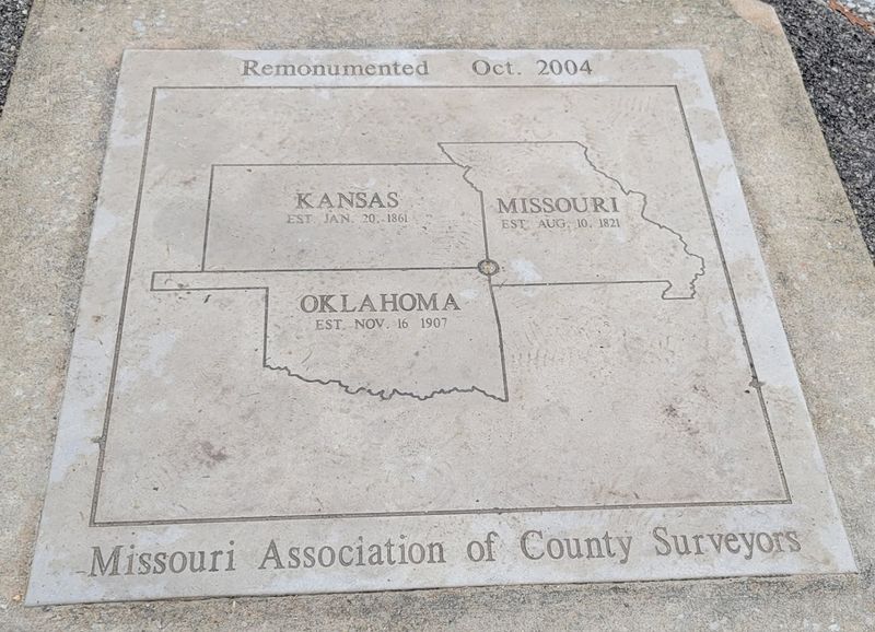
The address is 1183 SE 118th St, Joplin, MO 64804, but the real story here is geographic. This is the precise point where Oklahoma, Kansas, and Missouri share a single corner, and there is a granite marker planted right in the ground to prove it.
The spot sits in the far northeast corner of Oklahoma, just a short drive from Joplin, Missouri, which is the closest major city. Kansas is right there too, making this one of those rare places where three entirely different states are within a single arm’s reach.
Getting there takes about ten minutes off the main highway. You follow a short dirt road, pass a gravel pull-off, and suddenly you are standing at one of the more unusual geographic curiosities in the whole country.
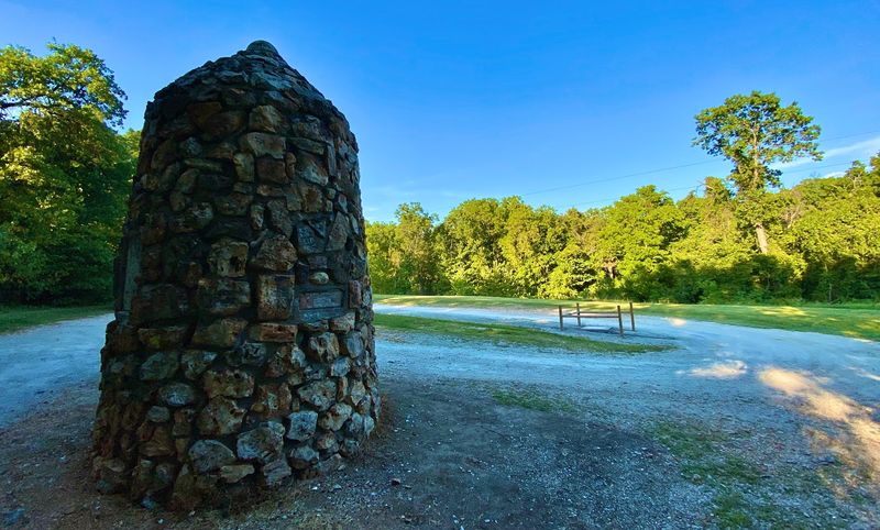
The surrounding landscape is quiet farmland with open skies in every direction, and the whole area has a peaceful, unhurried feel that makes the detour feel more than worthwhile.
Long before there was a marker, there were surveyors with chains and compasses trying to draw straight lines across a very uneven country. The western boundary of Missouri was established back in the 1830s, and the borders of Kansas and Oklahoma were hammered out later in the 19th century as the country expanded westward.
Here is a fun detail that surprises most visitors: the original stone marker placed at this site was actually off by about 50 feet from the true boundary point. That kind of surveying error was not unusual for the era, given the tools available at the time, but it does add a quirky footnote to the history of the place.
A newer, more accurate marker was eventually installed to mark the correct location. Both the old and new markers are still present at the site, which means you get a small but genuine history lesson just by looking around.
For anyone who enjoys the story of how America drew its borders, this spot delivers more depth than its simple appearance suggests.
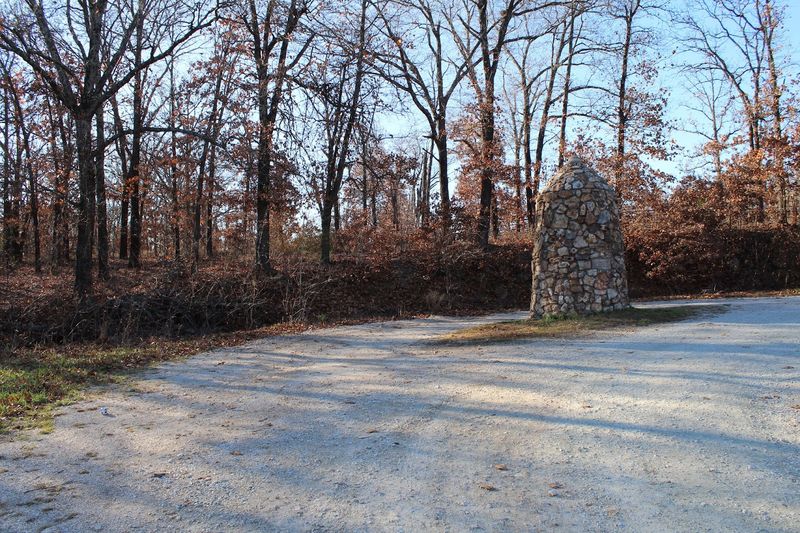
The main marker is a granite post set firmly into the earth, cleanly inscribed with the names of the three states it connects. There is nothing flashy about it, and that understated quality is actually part of its charm.
No neon signs, no souvenir kiosks, just a solid chunk of stone doing its geographic duty.
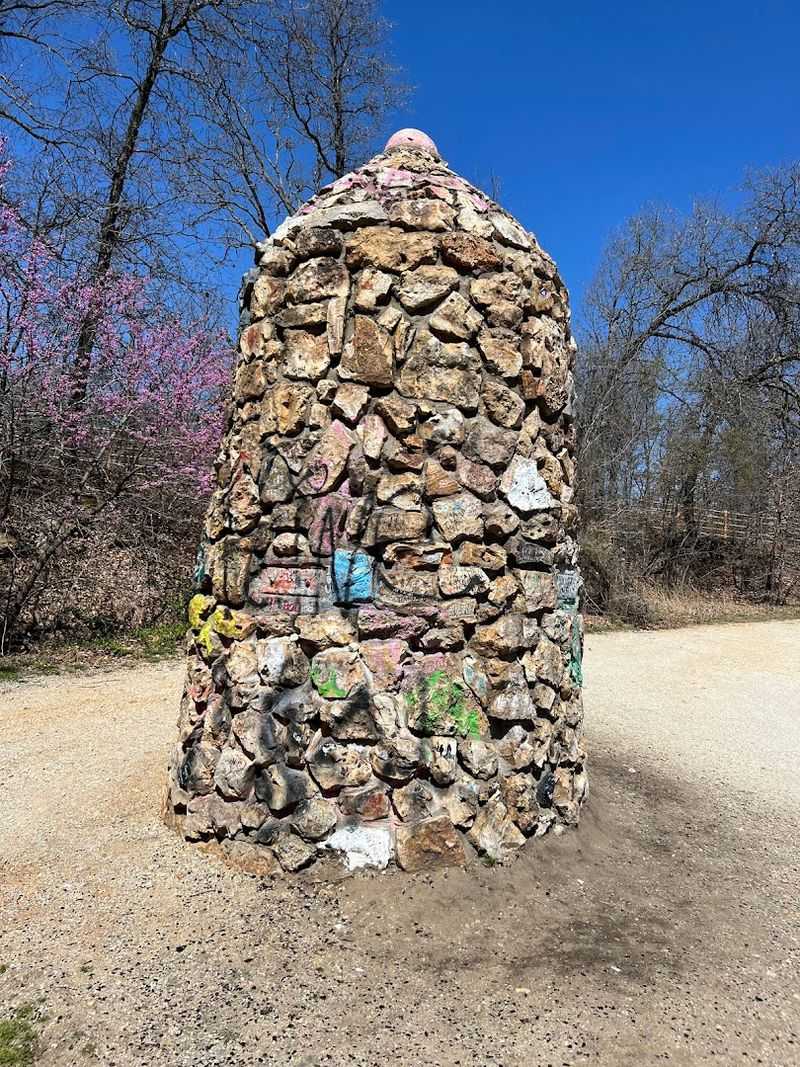
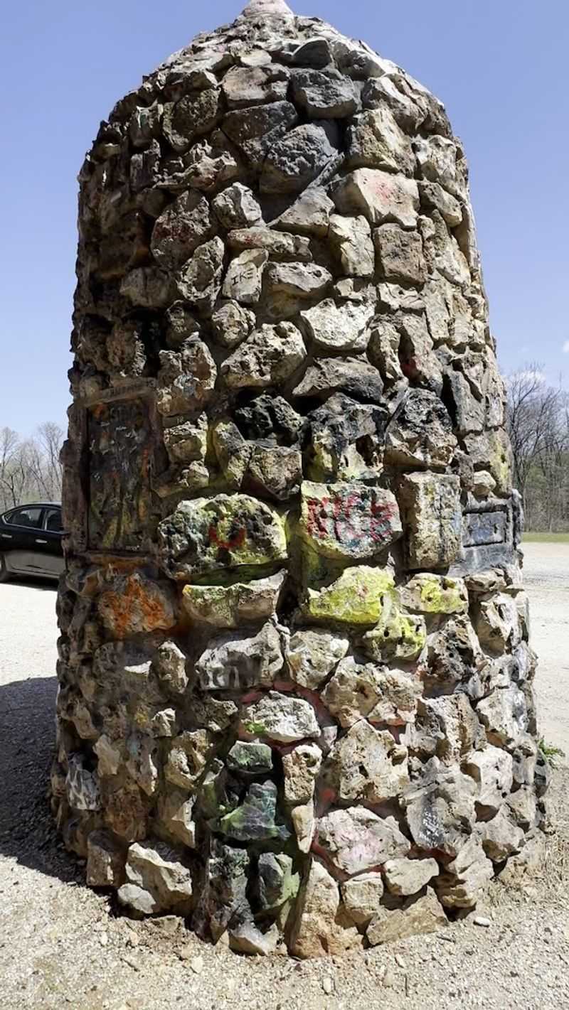
Near the newer marker, there is also a large stone pillar that catches your eye immediately when you arrive. Unfortunately, that structure has been heavily tagged with graffiti over the years, and some of the original plaques have been stolen or damaged.
It is genuinely disappointing to see a historical site treated that way, and most visitors agree that the spot deserves better care.
The newer concrete marker on the ground is where most people focus their attention, and it is in better shape. You can clearly see the boundary lines marked on its surface, which makes it easy to position yourself right at the meeting point of all three states.
The whole setup is simple but surprisingly satisfying to see in person.

Every single person who visits this spot eventually does the same thing: they try to position their body so they are technically in all three states at once. One foot in Kansas, one foot in Oklahoma, and some creative reaching toward Missouri.
It is completely ridiculous and completely irresistible.
Kids especially love this moment. There is something genuinely exciting about the idea of being in three places at the same time, and the marker makes it tangible in a way that a map never could.
Parents report that this stop tends to generate more enthusiasm than many far more elaborate tourist attractions.
The photo op is also surprisingly flexible. You can go for the full body stretch, the casual lean, or just stand right on the center point and let the marker do the talking behind you.
Either way, you walk away with a photo that is easy to explain and fun to show people who have never heard of the spot. It is the kind of travel memory that sticks around long after the trip is over.

The approach to the marker is easy once you know what to look for, but a few visitors have noted that there are no obvious signs from the main road. A GPS or mapping app set to the street address will get you there without any trouble, and the turn is clearly visible once you are looking for it.
From the highway, you take a short detour, wind around a roundabout near the Downstream Casino entrance, and then head about half a mile down a dirt road. The road is unpaved and can be a bit rough, so motorcycles may want to approach with caution.
Most standard vehicles handle it just fine.
There is a gravel area at the end where you can turn around and park comfortably. The whole trip from the highway to the marker and back takes maybe fifteen to twenty minutes, which makes it an easy addition to any road trip through the region.
Oklahoma, Kansas, and Missouri all converge here without demanding much of your schedule, which is a rare quality in a travel destination.
The marker is open around the clock, every day of the year, which gives you a lot of flexibility. That said, daytime visits are strongly recommended, especially for first-timers.
The road and the marker itself are not illuminated at night, and the surrounding woods can feel quite dark and a bit unsettling after sunset.
Morning visits tend to be especially pleasant. The light is soft, the air is cool, and the chances of having the place entirely to yourself are very high.
Most visitors report arriving to find no one else there, which adds to the peaceful, almost contemplative quality of the experience.
Late afternoon on a clear day is another strong option, since the low sun casts long shadows across the marker and makes for great photos. Rainy days are surprisingly popular with a certain type of visitor who enjoys the moody, quiet atmosphere.
Regardless of when you go, the visit itself is brief, so there is no need to plan around crowds or wait times. Oklahoma and its neighboring states are welcoming here any hour you choose to arrive.
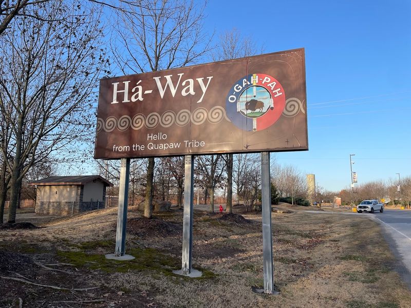
One of the more surprising neighbors of the tri-state marker is the Downstream Casino Resort, which sits just a short distance away. The casino is actually built on land in the Quapaw Nation territory, which is part of Oklahoma, making it a notable landmark in its own right for the area.
For road trippers, the casino’s presence is actually useful as a navigational landmark. When you see the Downstream Casino entrance sign, you know the marker is very close.
The turn for the marker comes just before the casino entrance, so keep your eyes open and do not overshoot it.
The casino also has a hotel, restaurants, and other amenities, which means you can pair your quick marker visit with a longer stop if you want a meal or a break from the road. The combination of a quirky historical landmark and a full-service resort nearby makes this stretch of the Oklahoma-Kansas-Missouri border more visitor-friendly than it might appear on a map.
It is a convenient pairing that many travelers take advantage of without planning for it in advance.
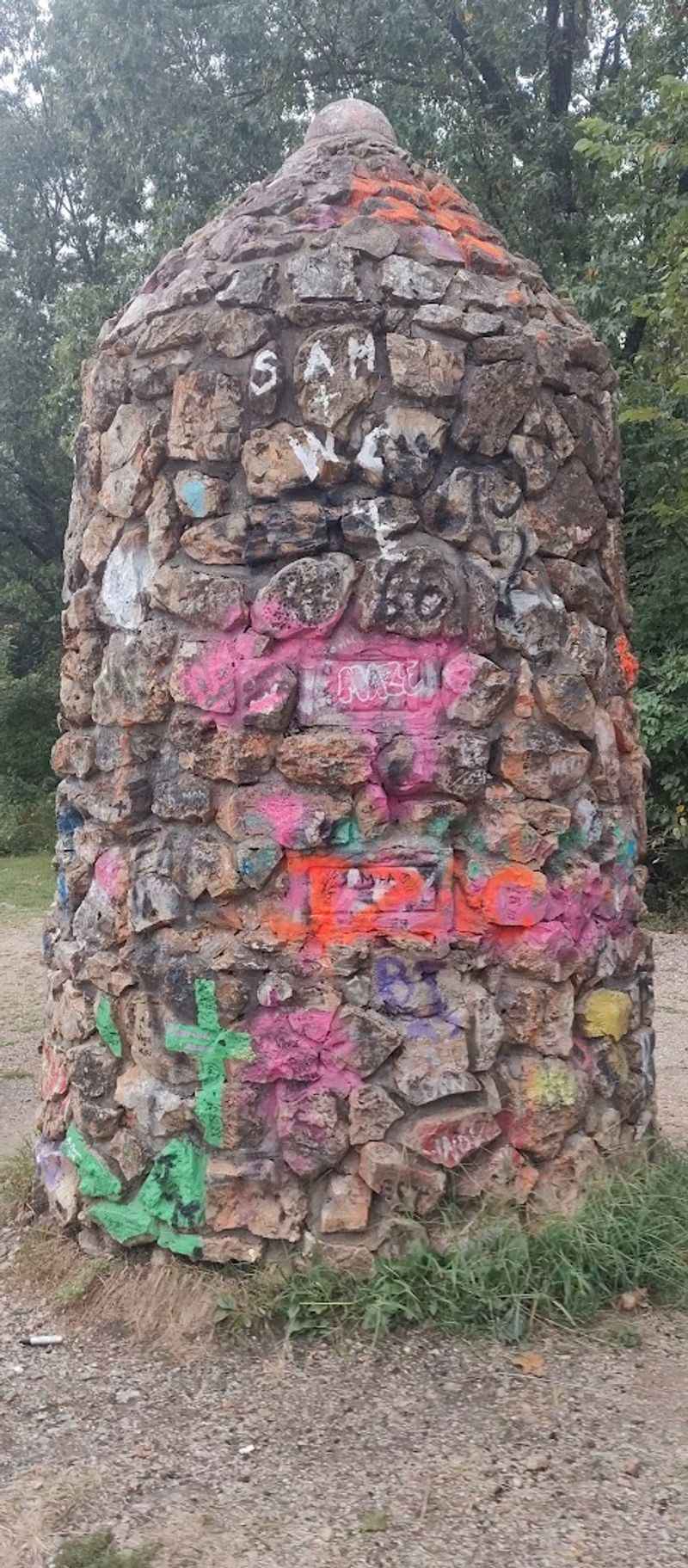
The large stone pillar near the marker has been a repeated target for vandalism over the years. Graffiti covers much of its surface, and some of the original bronze plaques have been stolen or broken off entirely.
It is one of those situations where a genuinely interesting historical site has been let down by a lack of maintenance and, frankly, a lack of respect from some visitors.
Many people who stop here mention the graffiti as the biggest drawback of the visit. The newer concrete marker on the ground is in better condition and is considered the actual boundary point, so the experience is not ruined, but the damaged pillar is hard to ignore.
It serves as an unpleasant reminder of what happens when a site goes without regular upkeep.
There have been calls from visitors for better preservation efforts, more signage, and possibly some lighting to discourage nighttime vandalism. Whether those improvements ever come through remains to be seen.
For now, the best approach is to focus on the newer marker, take your photos, and appreciate the historical significance of the spot for what it genuinely is rather than what it could be with a little more care.

Free, fast, and genuinely fun: those three words sum up the tri-state marker experience better than almost anything else. There is no admission fee, no parking cost, and no need to book anything in advance.
You pull up, walk about thirty seconds from your car, and you are standing at a point where three states meet.
The appeal crosses age groups in a way that few roadside stops manage. Young kids get a hands-on geography lesson.
Teenagers actually put their phones down to do the three-state pose. Adults who consider themselves too cool for roadside attractions end up grinning just as wide as everyone else.
There is something universally satisfying about standing at a boundary and knowing exactly where you are.
Road trip enthusiasts who collect unusual stops, geography fans, and history buffs all find something to appreciate here. Oklahoma, Kansas, and Missouri each have a claim on this small patch of earth, and that shared ownership gives the spot a quiet significance that goes beyond the novelty.
The detour is short, the experience is memorable, and the story you take home is one most people have never heard before.
A handful of practical notes can make your visit smoother. First, wear shoes you do not mind getting dusty or muddy, since the path to the marker is unpaved and can get soft after rain.
The walk from the parking area is short, but the ground is uneven in places.
Bring water, especially in warmer months, since there are no facilities at the site. No restrooms, no vending machines, no shade structures.
The visit is brief enough that this is rarely a problem, but it is worth knowing ahead of time so you are not caught off guard.
A camera or a fully charged phone is basically essential, since the whole point of the stop is the photo. Natural light works best, so midday sun or golden hour shots tend to come out the most vivid.
One last tip: watch out for wasps near the stone pillar, as visitors have spotted nests in and around that structure during warmer seasons. Keep a respectful distance from the old pillar and you will be just fine.
Oklahoma and its neighboring states are worth exploring carefully, and this little corner rewards the prepared traveler.


