Most people plan vacations to the Grand Canyon or Niagara Falls, but the USA is hiding some seriously jaw-dropping spots that most travel guides skip entirely. I stumbled onto a few of these by accident, and honestly, my mind has never quite recovered.
From alien-looking rock formations to glowing sea caves, these places look like they belong on another planet. Pack your bags and get ready to feel like a true explorer.
Devil’s Kettle, Minnesota
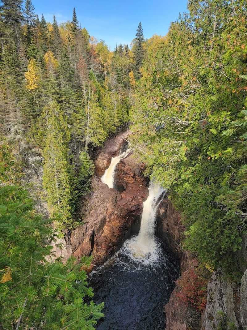
Nobody can explain where the water goes, and that alone makes Devil’s Kettle one of the strangest spots in the country. Located in Judge C.R.
Magney State Park, this waterfall splits in two. One half flows normally downstream.
The other half vanishes into a pothole and has never been found.
Scientists have tossed in ping pong balls, dye, and logs trying to track the water. Nothing ever showed up anywhere.
The mystery has been studied for decades without a solid answer.
Getting there requires a moderate two-mile hike through gorgeous boreal forest. The trail is well-marked and manageable for most fitness levels.
Fall is the best time to visit, when the surrounding trees burst into orange and red. Bring waterproof shoes because the rocks near the falls get slippery fast.
This is one of those places where you stand there thinking the universe is definitely keeping secrets from us.
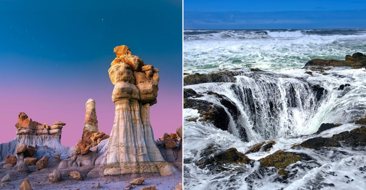
Bisti/De-Na-Zin Wilderness, New Mexico
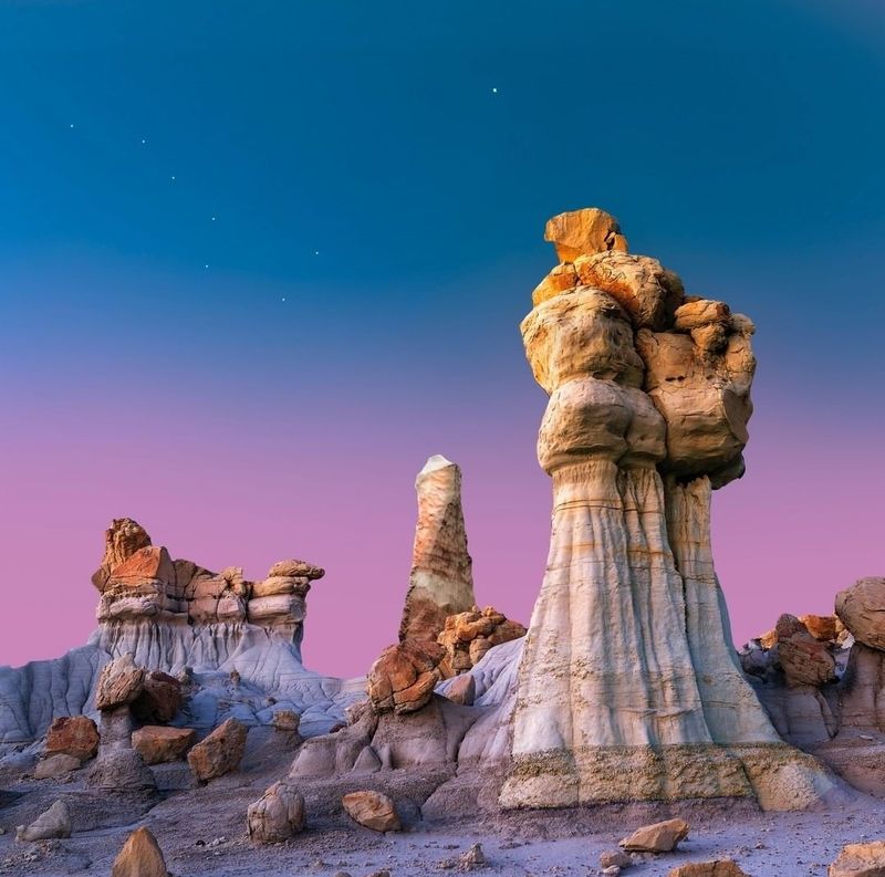
Walking through Bisti feels like accidentally wandering onto a film set for a sci-fi movie. There are no marked trails, no visitor center, and absolutely no crowds.
Just thousands of acres of crumbling hoodoos, petrified wood, and twisted rock sculptures that look nothing like anything on Earth.
The formations here are called “hoodoos” and they form when soft rock erodes unevenly, leaving bizarre mushroom-shaped pillars behind. Some look like alien eggs.
Others look like melted chess pieces. A few genuinely look like faces staring back at you.
Navigation is by GPS or compass only, so do your homework before heading out. Bring more water than you think you need because the high desert sun is no joke.
Early morning visits offer the best light for photos and cooler temperatures. Bisti sits about two hours from Albuquerque and rewards patient, adventurous travelers with landscapes that feel truly otherworldly.
Hamilton Pool Preserve, Texas
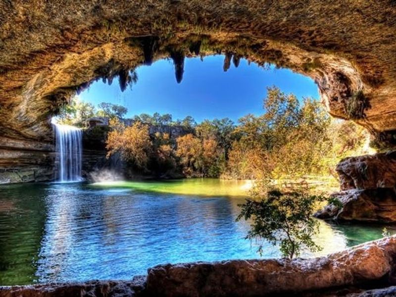
A collapsed grotto created one of Texas’s most breathtaking swimming holes, and locals have been keeping it quiet for years. Hamilton Pool Preserve sits about 30 miles west of Austin, tucked inside a canyon carved by Pedernales River tributaries.
The centerpiece is a gorgeous jade-green pool fed by a 50-foot waterfall.
The overhanging limestone ledge draped with ferns creates a natural canopy above the water. It genuinely looks like something out of a fairy tale.
Swimming is allowed when water quality tests pass, so always check the preserve’s website before making the trip.
Reservations are required year-round, and spots fill up fast, especially on weekends between May and September. Arriving early on weekdays is your best strategy.
The hike down to the pool is short but steep. Wear sturdy shoes and bring sunscreen.
The surrounding trails also offer great views of the canyon and local wildlife, making the whole visit worthwhile even if swimming is closed.
Dry Tortugas National Park, Florida
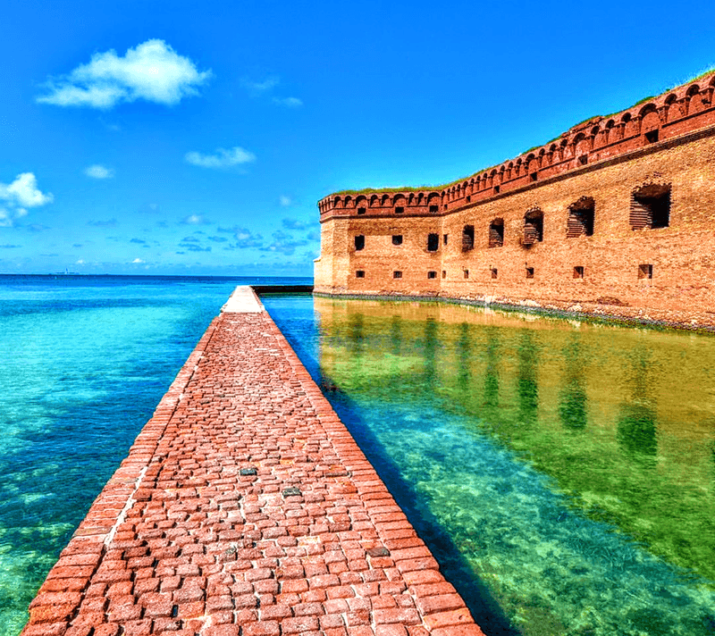
Seventy miles off the coast of Key West sits a place so remote that the only way to reach it is by seaplane or ferry. Dry Tortugas National Park is home to Fort Jefferson, a massive 19th-century military fort that was never fully completed and sits smack in the middle of the Gulf of Mexico like a brick island.
The water surrounding the fort is some of the clearest in the entire country. Snorkeling here means swimming alongside sea turtles, colorful reef fish, and coral formations that are shockingly well-preserved.
I once floated face-down for 20 minutes just watching a sea turtle cruise below me.
Camping overnight on the island puts you under one of the darkest, starriest skies imaginable. The park has no electricity and no fresh water, so you bring everything in and take everything out.
It feels genuinely wild in the best possible way. Book the ferry far in advance because this hidden gem is not so hidden anymore.
Chiricahua National Monument, Arizona
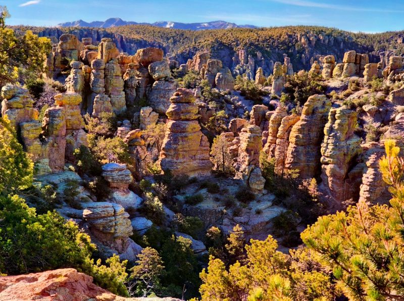
The Apache called this place “the land of standing-up rocks,” and once you see it, you completely understand why. Chiricahua National Monument in southeastern Arizona is packed with towering columns of balanced rocks, stacked so perfectly that they look like someone arranged them by hand over a very long weekend.
The rocks formed from volcanic ash deposited 27 million years ago during a massive eruption. Erosion slowly carved the ash into the wild formations visible today.
Some balanced boulders weigh hundreds of tons yet rest on tiny pedestals of stone.
The trail system here is excellent. The Echo Canyon Loop is the crowd favorite, weaving through narrow rock corridors and past jaw-dropping formations.
Chiricahua sits far from major cities, which keeps crowds low and wildlife activity high. Coatimundis, white-tailed deer, and over 170 bird species call this park home.
It is one of those parks where every turn in the trail delivers something unexpected and genuinely spectacular.
Apostle Islands Sea Caves, Wisconsin
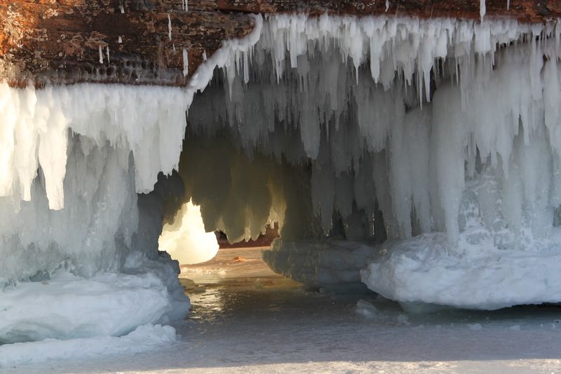
Lake Superior hides one of the most spectacular geological features in the Midwest, and most people drive right past it without knowing. The Apostle Islands sea caves are carved into red and brown sandstone cliffs along the Bayfield Peninsula, and the colors inside those caves are genuinely surreal.
In summer, kayakers paddle right into the caves and float under cathedral-like ceilings streaked with rust, cream, and charcoal. The light bouncing off the water creates a constantly shifting glow that no photo fully captures.
In winter, the caves freeze into curtains of blue and white ice that draw hikers across the frozen lake.
Both experiences are remarkable, but check conditions carefully before going. Lake Superior is unpredictable and commands respect.
Guided kayak tours depart from Meyers Beach and are perfect for first-timers. The surrounding Apostle Islands National Lakeshore also offers excellent camping and hiking.
This place is Wisconsin’s best-kept secret and absolutely worth the drive north.
Thor’s Well, Oregon
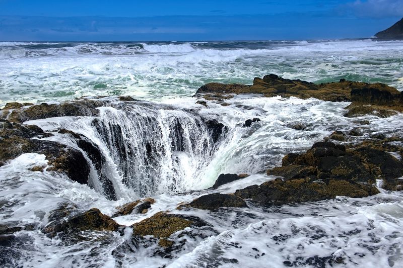
At first glance, Thor’s Well looks like the ocean is draining into a hole in the earth. This natural sinkhole sits in the rocky coastline near Cape Perpetua and pulls in waves with a dramatic sucking force before shooting them back up in a geyser-like spray.
It is theatrical, wild, and slightly terrifying.
The well is about 20 feet deep and sits just above sea level. During high tide, especially in stormy weather, it performs like nature’s most enthusiastic fountain.
Photographers camp out here for hours waiting for the perfect wave surge shot.
Timing your visit around high tide plus one hour gives the most dramatic show. Wear shoes with solid grip because the surrounding basalt rocks are constantly wet and dangerously slippery.
Keeping a safe distance is not optional here as waves arrive without warning. Thor’s Well is part of the Cape Perpetua Scenic Area, which also offers stunning coastal forest trails worth exploring after you have survived the spectacle.
Bonneville Salt Flats, Utah
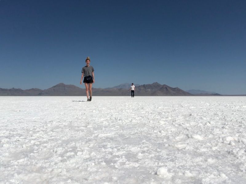
Standing on the Bonneville Salt Flats feels like standing on the moon, except the moon probably has fewer land speed records. This 30,000-acre salt crust in northwestern Utah is the result of ancient Lake Bonneville drying up over thousands of years, leaving behind a perfectly flat, blinding-white desert.
The flats are so flat and so white that they create wild optical illusions. Distant objects appear to float above the surface.
The horizon seems impossibly far away. It messes with your sense of scale in the most delightful way.
Speed racing enthusiasts know this place well as the site of hundreds of land speed records since the 1910s. Visitors can walk, drive, or even bike across the crust when it is dry enough.
The best time to visit is late summer after the seasonal flooding recedes. Sunrise and sunset turn the salt pink and gold, creating some of the most surreal photography opportunities in the entire country.
Entry is free.
Caddo Lake, Texas
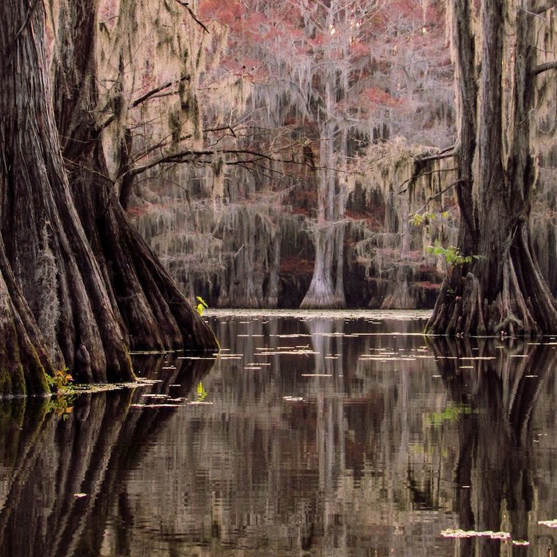
Caddo Lake is the only naturally formed lake in Texas, and it looks absolutely nothing like anything else in the state. Ancient bald cypress trees draped in Spanish moss rise from dark, still water.
Narrow channels wind through the swamp in a maze so complex that getting lost is practically a tradition here.
Caddo is the largest naturally occurring cypress swamp in North America. The trees can live over a thousand years, and some of the ones standing here were already ancient when European explorers first arrived.
Paddling through them feels like traveling back in time.
Renting a kayak or canoe from one of the local outfitters near Uncertain, Texas is the best way to explore. Guided boat tours are great for first-timers who do not want to navigate the waterways alone.
Wildlife is everywhere: alligators, herons, egrets, and turtles share the water without much concern for human visitors. Spring is gorgeous here, but honestly, every season brings something worth seeing.
Mono Lake, California
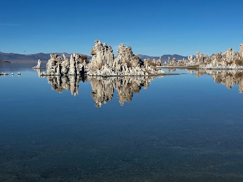
Mono Lake is older than most things you can think of. This ancient salt lake in eastern California has existed for over a million years and contains no fish, but it teems with brine shrimp and alkali flies that support millions of migratory birds.
The real showstoppers, though, are the tufa towers.
Tufa are calcium carbonate formations that built up underwater over thousands of years. When water diversions in the 1940s started dropping the lake level, the towers emerged like stone stalagmites rising from the water.
They look like something from a fantasy novel.
The South Tufa Area is the easiest access point and has a short interpretive trail that explains the lake’s fascinating history. Visiting at sunrise or sunset is worth setting an early alarm for, as the light on the towers and water is extraordinary.
Mono Lake is located along US-395 near Lee Vining, making it an ideal stop on a road trip through the Eastern Sierra.
Goblin Valley State Park, Utah
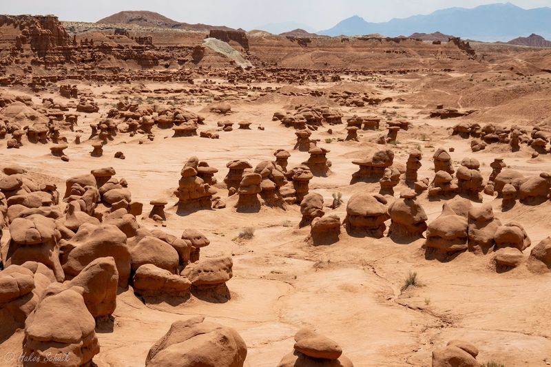
Utah has no shortage of weird landscapes, but Goblin Valley takes the prize for sheer strangeness. Thousands of sandstone hoodoos called “goblins” cover the valley floor like a crowd of stumpy, lumpy rock creatures that all froze mid-shuffle.
It is genuinely one of the most bizarre natural sights in North America.
The goblins formed from Entrada Sandstone that eroded at different rates, leaving rounded, mushroom-capped pillars in every shape you can think of. Kids go absolutely feral here, which is actually encouraged.
The park allows visitors to scramble freely among the formations, something most parks do not permit.
Three official hiking valleys let you wander through the goblins at your own pace. The main valley viewpoint is accessible even for young children.
Camping inside the park puts you right beside the formations under spectacularly dark skies. The park sits about four hours south of Salt Lake City.
Honestly, this place should be far more famous than it is.
Kasha-Katuwe Tent Rocks National Monument, New Mexico
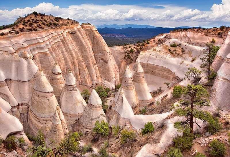
The name “Kasha-Katuwe” means “white cliffs” in the Keresan language of the Pueblo de Cochiti people, and the formations here more than live up to that name. Cone-shaped tent rocks rise from the canyon floor in perfect triangular points, some as tall as 90 feet, looking like a village of stone tepees arranged by a very tidy giant.
The rocks formed from volcanic eruptions 6 to 7 million years ago. Pumice and ash layers compressed and eroded into these sharp cones over time.
The layered pink, white, and tan colors make the whole place look like a giant layered dessert, which is a terrible analogy but accurate.
The Cave Loop and Canyon Trail combo is the must-do hike. It passes through a narrow slot canyon barely wide enough for your shoulders before emerging at a ridge with panoramic views.
The monument is located about 40 miles southwest of Santa Fe. Weekday visits are quieter and far more enjoyable.
Cumberland Island, Georgia
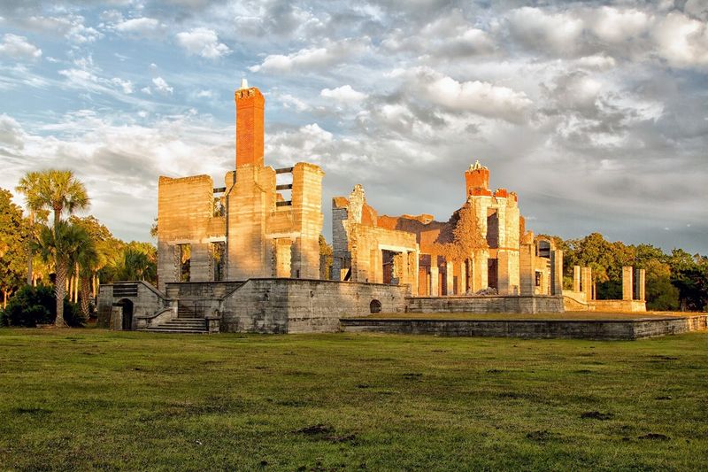
Wild horses roam a barrier island off the coast of Georgia, and almost nobody knows about it. Cumberland Island is the largest barrier island in the state, and it is home to about 150 feral horses that have lived there since the 1700s.
They wander the beaches, ruins, and maritime forest completely unbothered by human visitors.
The island also contains the crumbling ruins of Dungeness, a Carnegie family mansion abandoned in the early 20th century. Seeing wild horses graze in front of ivy-covered stone ruins is one of those genuinely surreal American experiences that feels almost too good to be real.
Access is by ferry only, departing from St. Marys, Georgia. The ferry runs limited days and carries limited passengers, so booking ahead is essential.
Most of the island has no roads, no shops, and no crowds. Camping is available at several sites, including one near the ruins.
Bring everything you need because the island has almost nothing for sale.
Great Sand Dunes National Park, Colorado
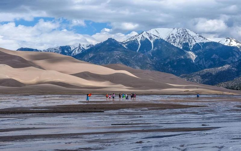
Colorado is famous for mountains, but it is also hiding the tallest sand dunes in North America, and they sit right at the base of a snow-capped mountain range. Great Sand Dunes National Park looks like someone dropped a piece of the Sahara into the Rockies and just left it there.
The dunes reach up to 750 feet tall and cover 30 square miles. They formed over thousands of years as wind carried sand from the San Luis Valley floor and deposited it against the Sangre de Cristo Mountains.
Medano Creek flows along the base of the dunes seasonally, creating a shallow beach-like area that is wildly popular with families.
Sandboarding and sand sledding are completely allowed here, and rental boards are available near the park entrance. Hiking to the top of High Dune is challenging but offers a view that justifies every step.
Summer mornings are ideal for hiking before the sand heats up to scorching temperatures. This park regularly stuns people who had no idea it existed.


