Our planet is full of surprises, and some of the most jaw-dropping ones aren’t made by human hands at all. From hexagonal rock columns to rocks that seem to move on their own, nature has been quietly sculpting masterpieces for millions of years.
These incredible formations attract millions of visitors every year, and once you see them, it’s easy to understand why. Get ready to discover 15 of the most bizarre, beautiful, and baffling natural wonders on Earth.
Giant’s Causeway — Northern Ireland
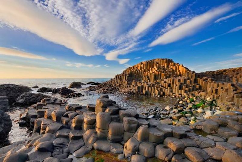
About 40,000 hexagonal basalt columns line the coast of Northern Ireland, and not a single one was placed there by human hands. That fact alone is enough to make your brain short-circuit.
The columns were formed around 50 to 60 million years ago when intense volcanic activity caused molten lava to cool and crack into these eerily perfect geometric shapes.
Local legend tells a different story. According to Irish mythology, a giant named Finn McCool built the causeway as a road to Scotland so he could fight a rival giant.
Whether you believe the science or the folklore, the result is equally stunning.
Visiting feels like stepping onto a natural chessboard that stretches into the sea. The columns range in height, with some towering over 12 meters tall.
UNESCO declared it a World Heritage Site in 1986, and it remains one of Ireland’s most visited landmarks. Wear sturdy shoes because the columns are uneven underfoot, and the coastal wind can be fierce.
Early morning visits offer fewer crowds and better light for photos. This is one spot where the real thing genuinely exceeds every expectation.
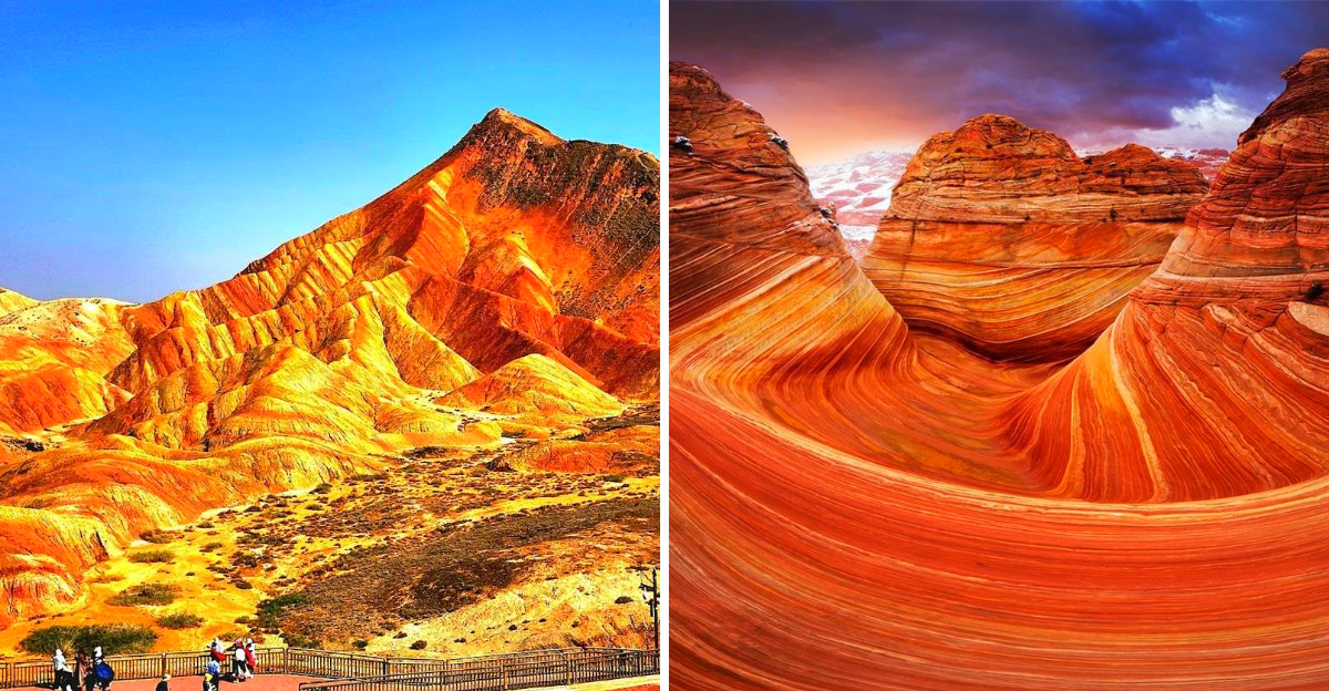
The Wave — Arizona, USA
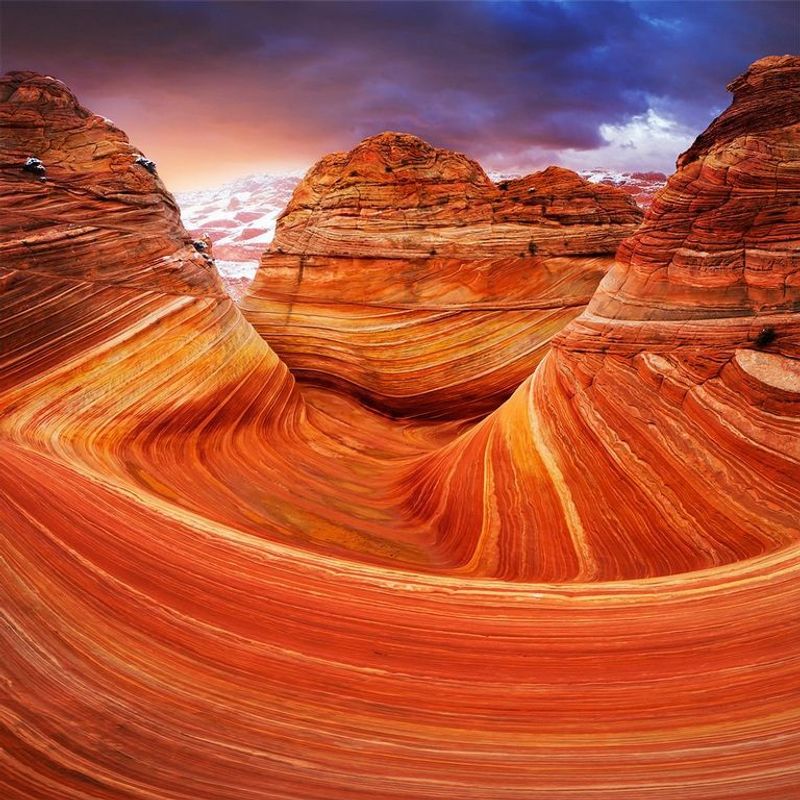
Only 64 people per day are allowed to visit The Wave, and permits are awarded by lottery. That exclusivity alone tells you this place is something extraordinary.
Tucked inside the Coyote Buttes North area of the Vermilion Cliffs National Monument, this sandstone masterpiece sits far from any paved road and rewards only the most determined travelers.
Wind and water spent millions of years carving these smooth, swirling layers into the rock. The result looks like someone froze a colorful ocean mid-wave and turned it to stone.
Shades of red, orange, pink, and cream blend together in flowing curves that seem almost too perfect to be real.
Photographers travel from all over the world just to capture this spot during golden hour, when the light makes every color pop. The hike to reach it is about six miles round trip with no marked trail, so a good map and navigation skills are essential.
Summer temperatures can be brutal, so early morning starts are strongly recommended. The Wave rewards those who plan carefully and come prepared.
Few natural formations on Earth carry this level of quiet, breathtaking drama.
Zhangye Danxia (Rainbow Mountains) — China
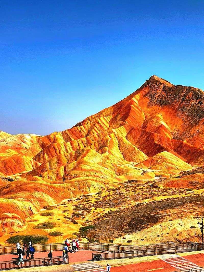
Bright red, golden yellow, olive green, and deep purple — these mountains look like someone took a paintbrush to the entire landscape. Zhangye Danxia in Gansu Province, China, is one of the most visually striking places on the planet.
The vivid stripes running across these hills are completely natural, formed over 24 million years by layers of mineral-rich sediment.
Red sandstone and other colorful minerals were compressed over time, then tilted and exposed by tectonic shifts. Erosion did the rest, carving the layers into rolling ridges that seem to glow from within.
After rainfall, the colors become even more saturated, making post-storm visits particularly spectacular.
The site became a UNESCO World Heritage Site in 2010 as part of the China Danxia group of geological parks. Wooden boardwalks and viewing platforms make it accessible to most visitors without damaging the fragile rock surface.
Sunrise and sunset are the best times to visit because the low-angle light intensifies the colors dramatically. Bring a wide-angle camera lens if you have one.
No filter needed here — the real thing is already more colorful than anything a screen can fully capture.
Moeraki Boulders — New Zealand
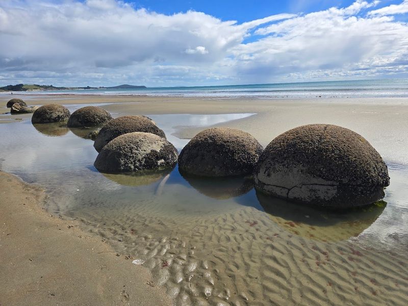
Scattered along Koekohe Beach on New Zealand’s South Island, these massive grey spheres look like they were dropped there by some giant playing marbles. Some are nearly two meters wide, and they sit half-buried in the sand with an almost casual confidence.
The Moeraki Boulders are among the most photographed natural features in New Zealand.
They formed on the ancient seafloor about 60 million years ago through a process called concretion. Minerals gradually crystallized around a central nucleus, layer by layer, the way a pearl forms inside an oyster — just on a much grander scale.
After the surrounding mudstone eroded away, the boulders were left exposed on the beach.
Maori legend offers a more colorful explanation: the boulders are the remains of calabashes, gourds, and eel baskets washed ashore from a legendary canoe called the Araiteuru. Both stories are fascinating in their own way.
The boulders are best visited at low tide when they sit fully exposed on the sand. Some have cracked open over time, revealing a crystalline interior that looks almost like honeycomb.
Sunrise here is genuinely magical, with the spheres casting long shadows across the wet sand.
Tsingy de Bemaraha — Madagascar
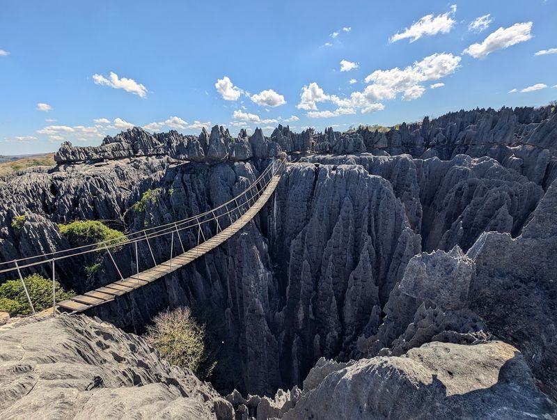
Walking through Tsingy de Bemaraha feels less like a hike and more like navigating a giant’s cheese grater. These razor-sharp limestone spires cover over 1,500 square kilometers in western Madagascar, creating one of the most hostile and awe-inspiring environments on Earth.
The word “tsingy” in Malagasy roughly translates to “where one cannot walk barefoot” — and that is a serious understatement.
The formation process began millions of years ago when rainwater slowly dissolved the limestone, carving deep channels and leaving behind knife-edged peaks. Some pinnacles reach heights of over 30 meters.
Remarkably, unique species of lemurs, birds, and plants have adapted to thrive in this seemingly impossible terrain.
UNESCO declared it a World Heritage Site in 1990, recognizing both its geological significance and extraordinary biodiversity. Guided tours with harnesses and via ferrata-style equipment allow adventurous visitors to cross suspension bridges and traverse the spires safely.
It is not a destination for casual tourists — physical fitness and a head for heights are both required. But for those who make the effort, Tsingy delivers an experience that feels genuinely otherworldly.
No other landscape on Earth looks quite like this one.
Cappadocia Fairy Chimneys — Turkey
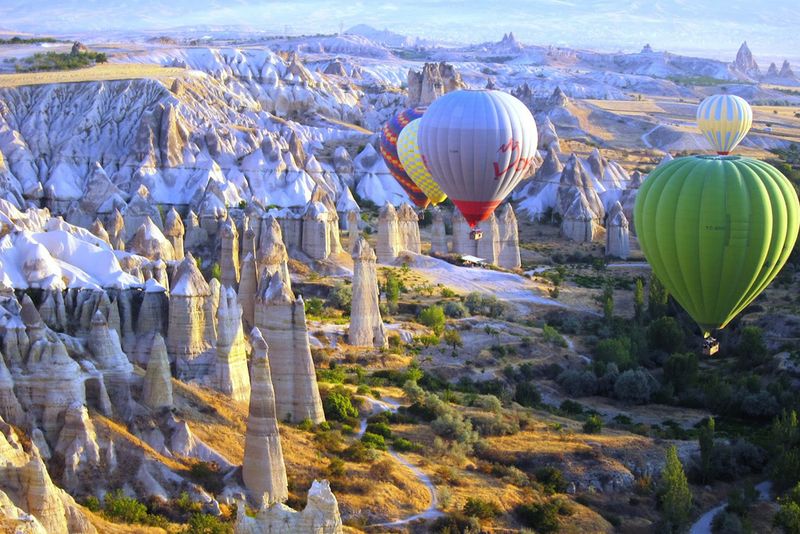
Hot air balloons floating above cone-shaped rock towers at sunrise — Cappadocia might be the most photographed region in Turkey, and the fairy chimneys are the reason why. These tall, narrow rock spires dot the valleys of central Turkey like something from a fantasy novel.
They were formed when volcanic eruptions covered the region in thick ash and lava millions of years ago.
Over time, wind and rain eroded the softer volcanic tufa rock while harder basalt caps on top resisted weathering. The result is these distinctive mushroom or cone-shaped pillars, some standing over 40 meters tall.
What makes Cappadocia even more remarkable is that ancient people carved homes, churches, and entire underground cities into the soft rock.
Some fairy chimneys have been converted into cave hotels, offering guests the surreal experience of sleeping inside a geological wonder. The region is also home to the famous Goreme Open Air Museum, a UNESCO World Heritage Site filled with rock-cut Byzantine churches decorated with frescoes.
The best way to appreciate the scale of the landscape is from above during a hot air balloon ride at dawn. Early morning light turns the valley golden, making it one of the most memorable views in the world.
Salar de Uyuni — Bolivia
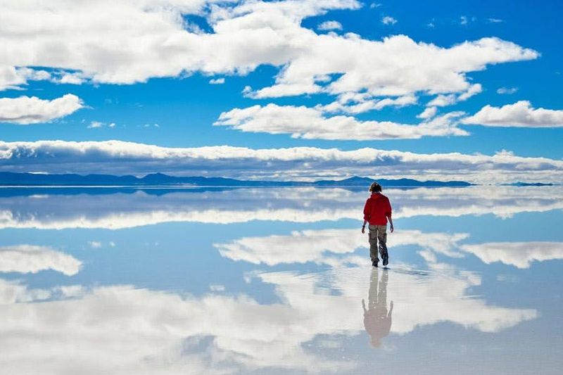
Standing on the world’s largest mirror sounds like something from a dream, but at Salar de Uyuni in Bolivia, it’s just a Tuesday after the rains. Covering over 10,500 square kilometers at an elevation of 3,656 meters, this massive salt flat transforms into a flawless reflecting pool when a thin layer of water floods the surface during the wet season.
The salt flat was formed from prehistoric lakes that evaporated thousands of years ago, leaving behind a crust of salt up to ten meters thick in some areas. It contains about half of the world’s known lithium reserves, making it economically significant beyond its jaw-dropping beauty.
The area also hosts unusual cactus-covered islands rising from the flat white expanse.
During the dry season, the surface cracks into geometric hexagonal patterns that stretch as far as the eye can see. Both versions of the landscape are spectacular in completely different ways.
Photographers love the wet season for the mirror effect, while the dry season offers cleaner geometric patterns and easier driving. Nights here are extraordinary too — the altitude and lack of light pollution make the star-filled sky almost unbelievably clear.
Few places on Earth offer this much visual variety in one location.
Devil’s Tower — Wyoming, USA
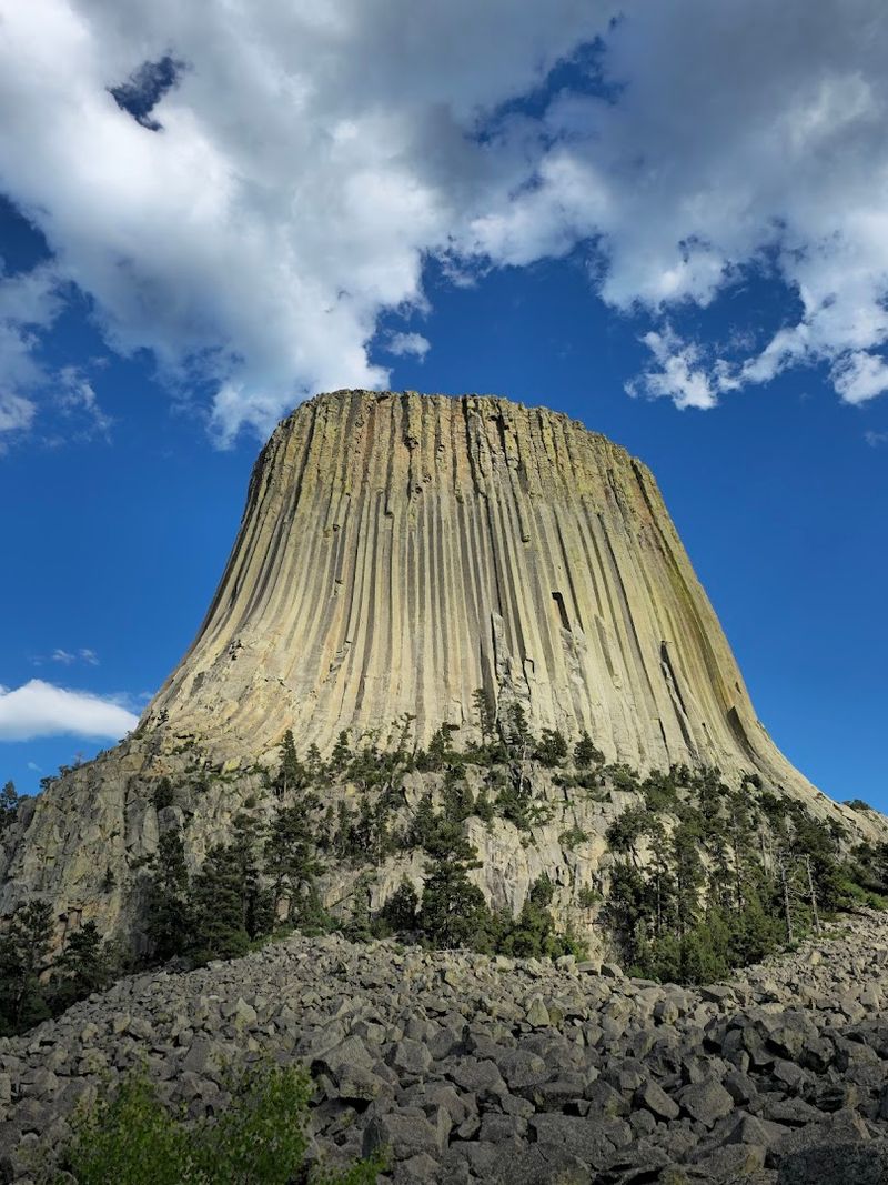
Rising 386 meters above the surrounding plains like a forgotten skyscraper, Devil’s Tower in Wyoming stops most people dead in their tracks the first time they see it. This massive column of igneous rock has vertical ridges running from base to top, giving it a distinctive grooved appearance unlike any other geological feature in the United States.
It was the first national monument designated in the country, declared by President Theodore Roosevelt in 1906.
Geologists believe it formed when magma intruded into surrounding rock and slowly cooled underground. The softer sedimentary rock around it eroded away over millions of years, leaving this hard igneous core standing alone.
The vertical columns formed as the rock contracted during cooling, similar to the process that created Giant’s Causeway.
Devil’s Tower holds deep spiritual significance for over 20 Native American tribes, including the Lakota, Cheyenne, and Kiowa. Many refer to it as Bear Lodge.
Rock climbers are drawn to its vertical columns, but climbing is voluntarily discouraged during June out of respect for Native American ceremonies. A walking trail circles the base, offering stunning views from every angle.
Watching the tower change color as the sun moves across the sky is a surprisingly moving experience.
Awa Sand Pillars — Japan
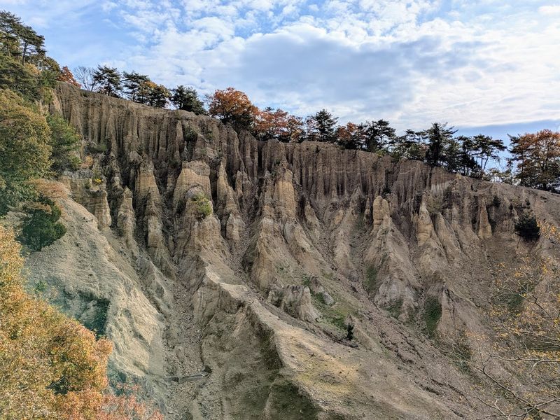
Tucked away in Tokushima Prefecture on Shikoku Island, the Awa Sand Pillars are one of Japan’s most underrated geological curiosities. These slender rock spires, known internationally as hoodoos, rise from eroded hillsides in shapes that look almost hand-sculpted.
They formed through differential erosion — where softer sediment layers wear away faster than the harder rock sitting above them, leaving these delicate columns standing like natural sentinels.
The pillars range from small stumpy formations to impressively tall spires, and the landscape shifts dramatically depending on the season. Heavy rainfall accelerates the erosion, meaning the formations are slowly but constantly changing over time.
Visiting a few years apart could show a noticeably different landscape.
Unlike many of Japan’s more famous tourist sites, the Awa Sand Pillars remain relatively uncrowded, making them a peaceful and rewarding detour for travelers exploring Shikoku. The surrounding area offers hiking trails with views of the pillars from multiple angles.
The formations are particularly photogenic in the soft light of late afternoon, when shadows deepen the textures and make each spire look even more dramatic. For geology enthusiasts or anyone who enjoys discovering places most tourists overlook, this quiet corner of Japan delivers something genuinely memorable.
Yehliu Geopark — Taiwan
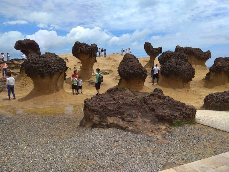
“Queen’s Head” is just a rock — but it’s a rock that has had its own security guard. Yehliu Geopark on Taiwan’s northern coast is home to one of the most recognizable rock formations in Asia: a naturally carved stone that bears an uncanny resemblance to the profile of a noble woman with an elaborate hairstyle.
Thousands of visitors line up daily just to photograph it.
The park stretches along a narrow cape into the ocean, and the combination of sea erosion, salt weathering, and tectonic uplift has produced an astonishing variety of shapes. Beyond the Queen’s Head, visitors can spot formations resembling candles, mushrooms, icebergs, and even a fairy shoe.
Each one has been given its own nickname by locals.
The rock formations are made of sandstone and mudstone, and they continue to erode slowly every year. The Queen’s Head’s neck has grown noticeably thinner over decades, and scientists predict it may eventually break.
Admission to the park is affordable, and the coastal setting adds a dramatic backdrop to every photo. Visiting on a weekday morning helps avoid the biggest crowds.
Yehliu is a reminder that nature, given enough time and the right conditions, can produce art that no sculptor could ever match.
The Pinnacles — Australia
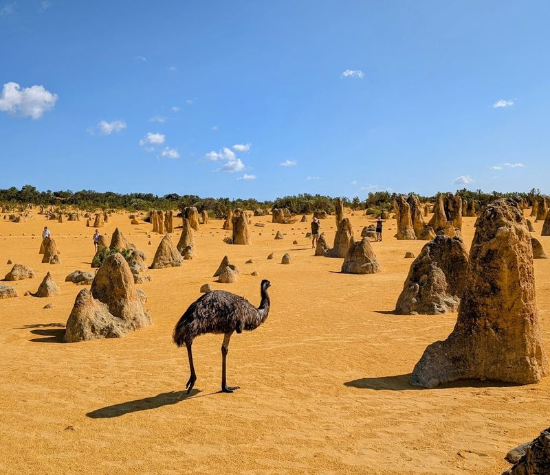
Hundreds of ancient limestone spires jutting out of golden desert sand — The Pinnacles in Western Australia look like the ruins of a city that never existed. Located in Nambung National Park about two hours north of Perth, these formations range from small stubby rocks to towering columns nearly four meters tall.
They stretch across the desert in their thousands, creating a landscape that feels deeply alien.
How they formed is still a topic of scientific debate. The most widely accepted theory suggests that seashells left by an ancient ocean were broken down into lime-rich sand, which was later cemented by groundwater into hard limestone.
Wind then eroded the surrounding sand, gradually exposing the pillars we see today. The process took tens of thousands of years.
Kangaroos and emus are commonly spotted wandering between the spires, adding a distinctly Australian touch to an already surreal scene. A sealed road loops through the park, making it accessible even for those who prefer not to walk in the heat.
Sunset is the most popular time to visit because the warm light turns the sand and spires a deep amber color. The Pinnacles prove that some of the most extraordinary landscapes on Earth are hiding in places most people drive right past.
Stone Forest (Shilin) — China
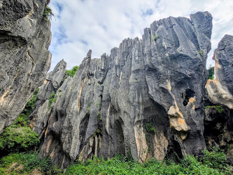
Imagine walking through a forest where every single tree has turned to stone. That is the best way to prepare yourself for Shilin, the Stone Forest of Yunnan Province in China.
Over 400 square kilometers of sharp grey limestone pillars rise from the ground, some reaching heights of 30 meters, creating a maze-like landscape that has amazed visitors for centuries. Emperor Qianlong of the Qing Dynasty reportedly visited and was left speechless.
The formation began about 270 million years ago when this entire region was covered by a shallow sea. As the seabed was slowly pushed upward by tectonic forces, rainwater began dissolving and eroding the exposed limestone along natural cracks.
Over millions of years, the gaps widened and deepened, leaving behind these dramatic stone towers.
Shilin was designated a UNESCO World Heritage Site in 2007 as part of the South China Karst. The local Sani people, a branch of the Yi ethnic group, have lived alongside the stone forest for generations and consider it sacred.
Guided tours are available in multiple languages, and the park includes several distinct zones with different types of formations. The major scenic area alone takes several hours to explore properly.
Comfortable walking shoes are essential — the paths between the rocks are uneven and surprisingly extensive.
Elephant Rock — Iceland
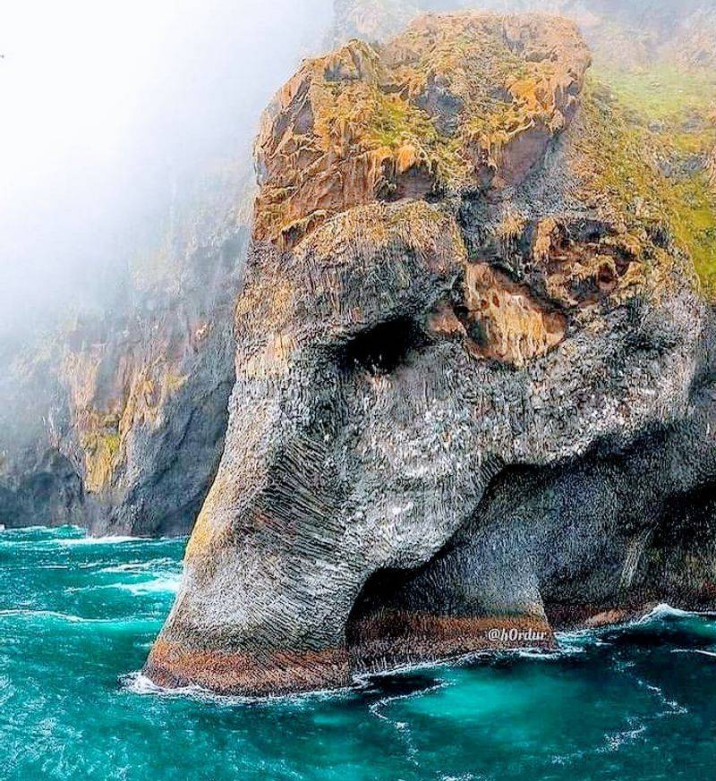
Nature occasionally produces something so perfectly shaped that it stops being geology and starts being comedy. Elephant Rock on Heimaey Island in Iceland is one of those moments.
This massive basalt formation rises from the sea with a shape so convincingly elephant-like — complete with a trunk dipping into the water — that first-time visitors often do a double-take to confirm it is not a sculpture.
The formation is entirely natural, shaped by two forces working in combination over thousands of years. Lava from volcanic activity created the original rock mass, while relentless wave action and ocean erosion gradually carved away the softer sections, leaving the harder basalt in this improbable pachyderm pose.
The dark rock against Iceland’s often stormy grey skies makes it even more dramatic in photographs.
Heimaey is the largest of the Westman Islands and is accessible by ferry from the mainland. The island itself has a fascinating geological history — a volcanic eruption in 1973 nearly buried the town and dramatically changed the island’s coastline.
Elephant Rock is best viewed from a boat tour, which allows you to get close enough to appreciate the full scale of the formation. It has become one of Iceland’s most charming and frequently photographed geological oddities, beloved for being equal parts science and spectacle.
White Desert — Egypt
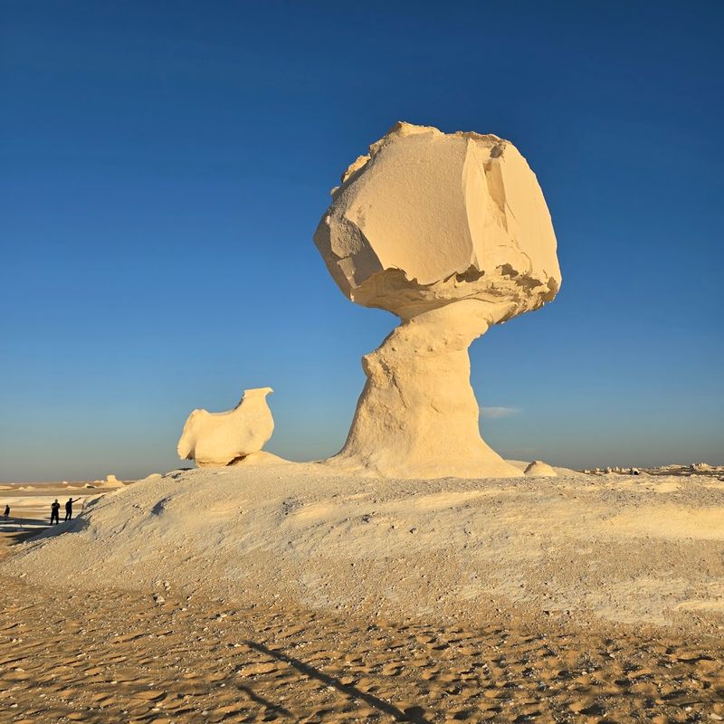
Standing in Egypt’s White Desert feels less like being on Earth and more like landing on some pale alien moon. Located in the Farafra region of the Western Desert, this protected area is filled with hundreds of brilliant white chalk formations that wind has sculpted into extraordinary shapes over thousands of years.
Mushrooms, chickens, camels, and abstract forms — the landscape doubles as an open-air art exhibition curated entirely by the wind.
The chalk was deposited during the Cretaceous period when this entire region was covered by a shallow sea. After the sea retreated, the exposed chalk was left to the mercy of desert winds loaded with sand particles.
That abrasive combination slowly carved the softer lower sections of the rock faster than the tops, creating the distinctive mushroom shapes scattered across the desert floor.
Camping overnight in the White Desert is a bucket-list experience for adventurous travelers. Under a full moon, the white formations glow with an almost supernatural brightness that makes the whole landscape feel dreamlike.
Guided jeep tours from nearby Bahariya Oasis typically include an overnight stay. The temperature drops sharply after sunset, so warm layers are essential even in summer.
Egypt is famous for its ancient human-made wonders, but the White Desert proves the country’s natural wonders deserve equal attention.
Sailing Stones — Death Valley, USA
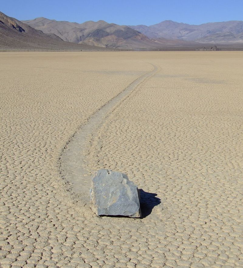
For decades, these rocks moved at night — or so it seemed. The Sailing Stones of Racetrack Playa in Death Valley, California, left long visible trails across the cracked dry lakebed, yet no one ever saw them move and no human or animal tracks accompanied them.
The mystery attracted scientists, conspiracy theorists, and curious visitors for generations.
The answer, finally confirmed in 2014, turned out to be beautifully simple. During rare winter conditions, thin sheets of ice form on the playa overnight.
As the ice melts and breaks up during the morning sun, wind pushes the floating ice panels across the wet mud surface. Rocks trapped in or against the ice get carried along for the ride, scratching trails into the soft sediment beneath.
The trails can stretch for hundreds of meters, and the rocks range from small pebbles to boulders weighing several hundred kilograms. What makes the sight so eerie is the stillness of the landscape — a flat, empty lakebed with rocks sitting at the ends of their own tracks, looking like they simply decided to go for a walk.
Death Valley is already one of the most extreme environments on Earth, and the Sailing Stones add a layer of quiet strangeness that makes visiting feel genuinely unforgettable.


