Some towns make their best first impression from a hilltop, a drone photo, or an airplane window, because their real magic is in the pattern. Streets curl like neat handwriting, rooftops gather in tidy clusters, and whole neighborhoods reveal designs you would never fully catch at eye level.
In this lineup, you are getting the places where color, geography, and old planning habits team up to create unforgettable overhead views, from blue mountain lanes to cliffside stacks and canal webs that look almost too orderly to be real. Keep reading and you will see why these 14 towns are not just lovely to visit on foot, but downright show-offs when seen from above.
1. Hallstatt – Austria
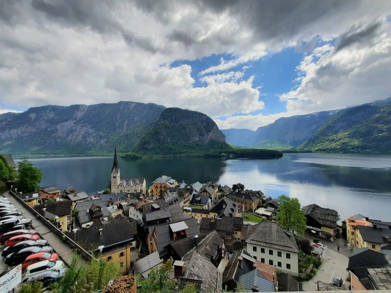
Hallstatt looks like someone arranged a model village between a mountain wall and a lake, then forgot to make it full size. From above, that narrow strip of land becomes the whole story: rows of tidy houses, a sharp church spire, and almost no wasted space between rock and water.
The town’s shape is unusually compact because there was never much room to expand, and that limitation gives its aerial view real character. Rooflines cluster tightly along the shore, while small lanes branch in short, practical lines rather than grand boulevards.
You can also spot how the cemetery, market square, and boat landings fit into a settlement that had to think carefully about every meter.
I find Hallstatt especially striking because the overhead perspective shows the logic behind its postcard reputation. It is not just pretty.
It is efficient, historic, and so neatly placed that it almost feels politely introduced to the landscape rather than dropped onto it.
2. Burano – Italy
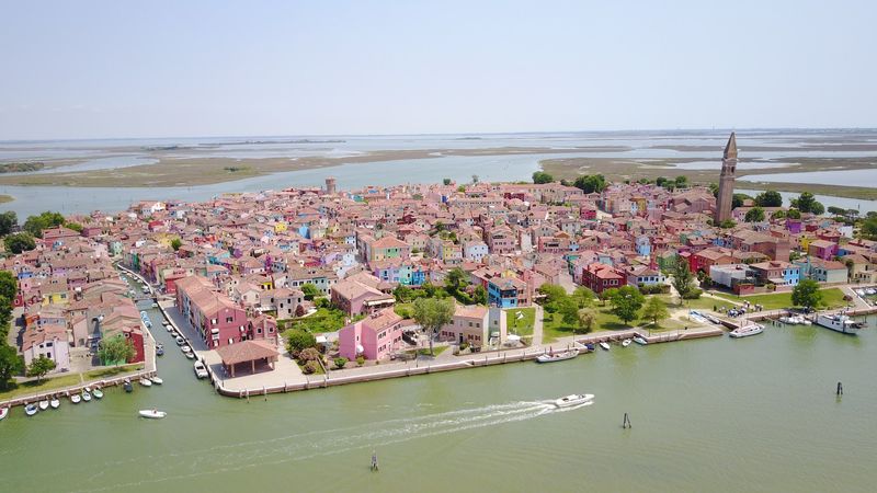
Color does the heavy lifting in Burano, and from above it works overtime. The island’s candy-bright houses line the canals in crisp blocks of pink, yellow, green, blue, and red, creating an aerial view that looks wonderfully organized even when the palette seems to ignore all restraint.
What makes Burano so satisfying from the sky is the repetition. Small homes sit shoulder to shoulder, canals cut clean paths through the neighborhood, and bridges connect the sections like simple stitches across fabric.
The colors are not random either, since residents traditionally follow local rules when painting facades, which helps keep the island’s bold identity intact. That means aerial photos show both personality and structure at once.
I like Burano because it proves order does not need beige to succeed. From above, the island feels playful but precise, and the surrounding lagoon gives those bright rows extra clarity.
It is a town that clearly understood the assignment and brought its own paint chart.
3. Chefchaouen – Morocco
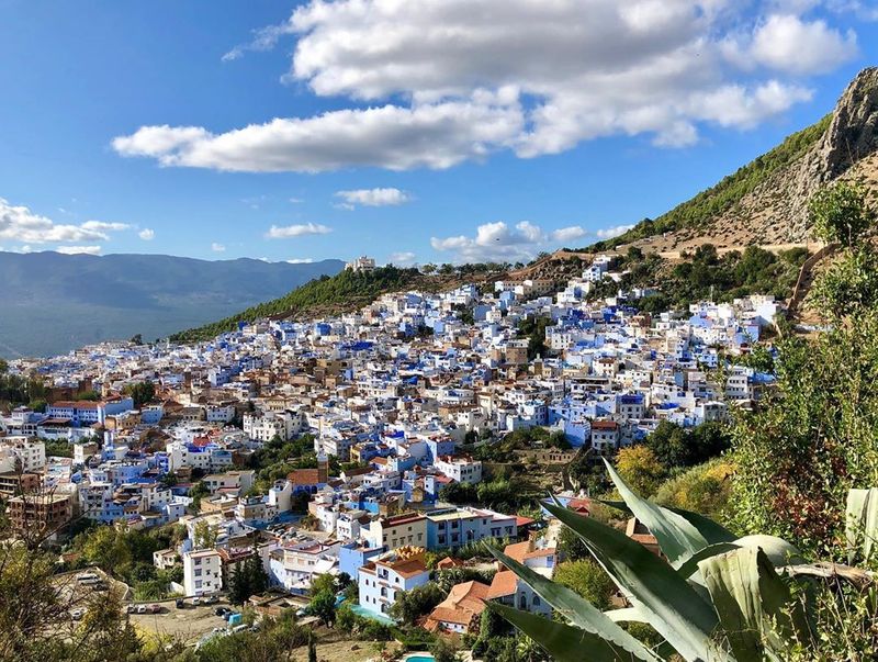
Blue wins by a landslide in Chefchaouen, where rooftops, walls, stairways, and alleys gather into a mountain town that looks almost custom-made for aerial photography. From above, the famous painted medina becomes more than a charming color story.
It turns into a dense mosaic of soft blues, white accents, and earthy rooflines set against the Rif Mountains.
The town’s hillside position adds extra interest because streets do not follow a strict grid. Instead, they bend, narrow, and overlap in ways that reflect older building patterns, creating a layered overhead view full of compact courtyards and irregular shapes.
You can see how the medina stays tightly knit while newer sections spread outward with wider roads and less visual drama. That contrast makes the historic center stand out even more clearly.
I think Chefchaouen looks best from above because the blue reads as a unified design rather than a series of painted walls. It is calm, distinctive, and exceptionally easy to recognize.
4. Positano – Italy
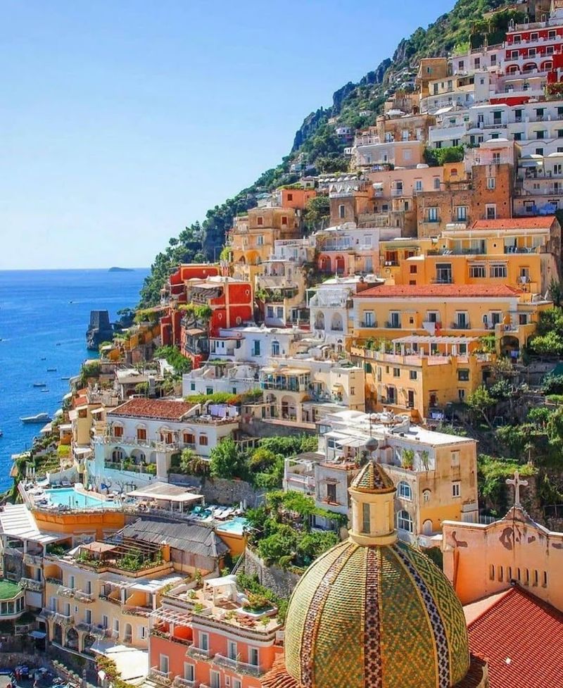
Positano does not believe in flat terrain, and that is exactly why it looks so good from above. Its pastel buildings stack tightly down a steep hillside toward the sea, making the whole town resemble a carefully arranged cascade of balconies, stairways, hotels, and homes with almost no empty space in between.
The overhead perspective reveals how little room there really is. Roads loop and pinch, steps take over where cars cannot, and every structure seems to negotiate directly with gravity.
You can trace the town’s vertical logic from the upper slopes to the beach, where the compact street plan finally exhales into a narrow waterfront. Unlike many seaside towns that spread sideways, Positano drops downward in dramatic layers, which gives drone images and hilltop views their signature depth.
I keep coming back to the way the architecture follows the slope with such confidence. From above, Positano looks intricate without appearing chaotic, and the curve of the coastline gives the whole composition a sharp finishing line.
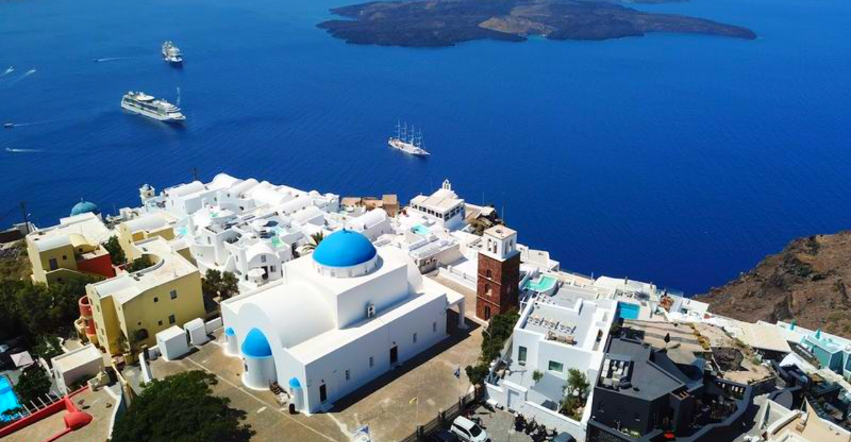
5. Santorini – Greece
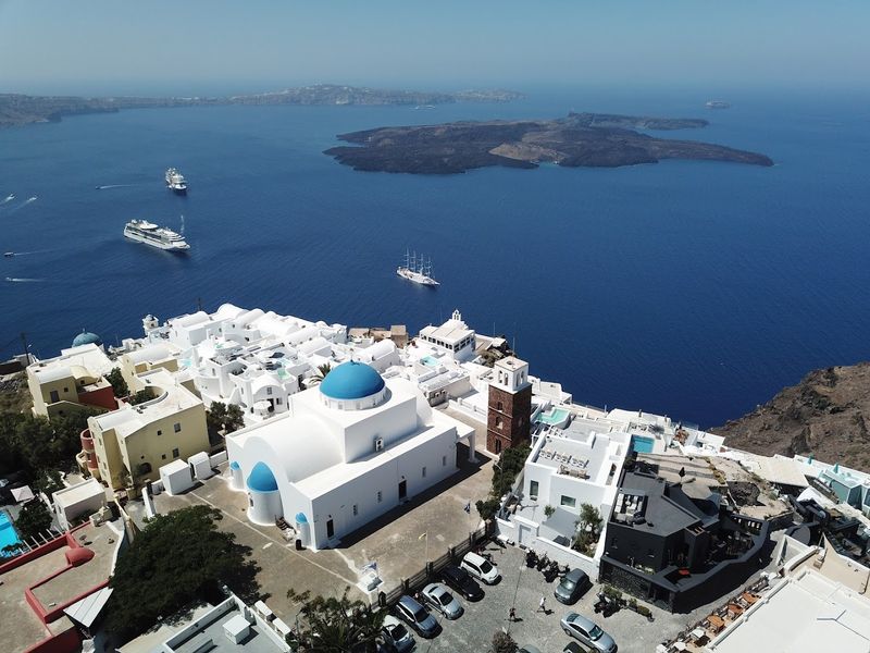
Gravity seems to have taken a creative writing class in Santorini, where houses tumble down the caldera in bright white tiers and every rooftop looks carefully placed for maximum drama. From above, the town reads like a clean geometric puzzle, with lanes too narrow for cars and terraces stacked so tightly they appear almost stitched into the cliff.
You can trace the island’s volcanic story in the dark rock, the crescent coastline, and the way villages cling to the rim rather than spread inland. Blue domes punctuate the white buildings with remarkable precision, especially in Oia and Fira, giving aerial photos their famous color contrast without needing any filter tricks.
I love that the layout is both beautiful and practical, designed around steep terrain and sea views.
Seen from the sky, Santorini is less a town and more a masterclass in making difficult geography look effortlessly stylish. It is architecture with excellent posture.
6. Colmar – France
Colmar serves up a roofscape so tidy that even people who claim not to care about urban layout may suddenly develop opinions. From above, the old town shows off red tiled roofs, narrow streets, and canals threading between half-timbered buildings in a way that feels both medieval and neatly edited.
The appeal here is not one dramatic landmark but the overall pattern. Blocks are compact, facades sit close together, and the canal sections around Little Venice add graceful curves to a street plan that might otherwise feel strictly practical.
Aerial views also highlight how well preserved the historic core remains, with relatively consistent building heights and very few interruptions from modern development. That continuity makes the town look coherent rather than patched together.
I like Colmar because it rewards close inspection. At first glance, you get color and symmetry.
A second look reveals courtyards, market squares, church towers, and tiny lanes arranged with the kind of confidence old towns developed long before anyone imagined drone photography would arrive and applaud.
7. Giethoorn – Netherlands
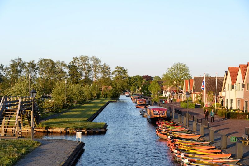
Roads take a polite step back in Giethoorn, and the canals steal the entire show. From above, the village looks like a network diagram drawn by someone with a fondness for water, footbridges, and thatched roofs, with long narrow plots stretching out behind houses in impressively orderly fashion.
The old center is especially striking because so much movement happens by boat or on foot. Waterways run where streets might sit in most towns, and small bridges hop from bank to bank with remarkable frequency, giving aerial photos a lace-like pattern.
The cottages line up beside the canals with gardens and trees softening the geometry without hiding it. Because the settlement developed on peatland, the layout reflects both environmental limits and local ingenuity rather than grand planning theory.
I find Giethoorn fascinating from above because it is easy to read and unusual at the same time. You instantly understand how it works, yet it still feels delightfully improbable, as though the village simply decided cars were too ordinary and moved on.
8. Cinque Terre (Vernazza) – Italy
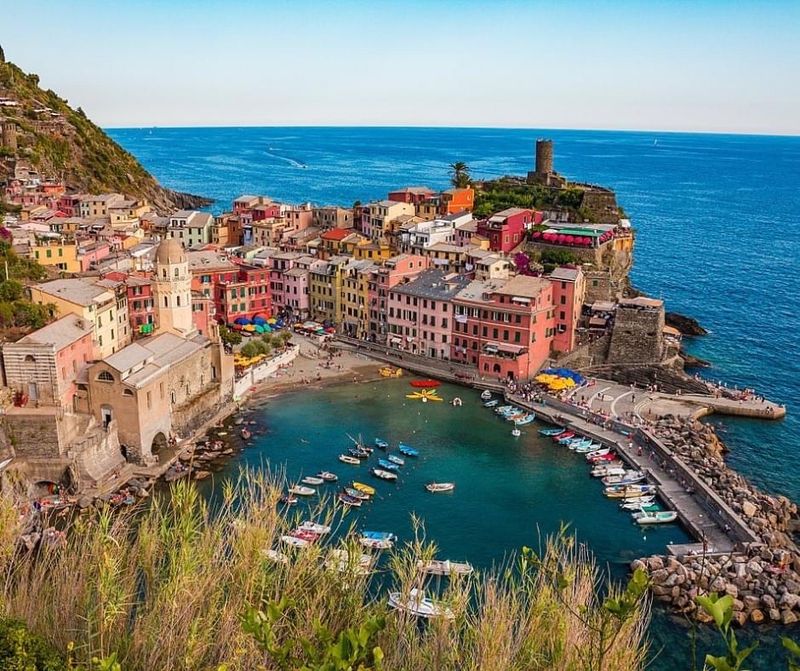
Vernazza wastes absolutely no time being memorable from above, thanks to its tight harbor, bright buildings, and cliffs that seem determined to keep everything compact. The village appears as a colorful knot tied between sea and hillside, with homes packed around a small marina and narrow lanes climbing sharply upward.
That close fit is what makes the aerial view so effective. The harbor forms a natural focal point, the church and tower add vertical punctuation, and the surrounding terraces show how people shaped the slopes for practical use long before scenic photos turned them into global celebrities.
Unlike larger coastal towns with sprawling neighborhoods, Vernazza stays visually concentrated, which gives it real punch in overhead images. You can understand the whole settlement in one glance, yet still notice layers of stairs, retaining walls, and stacked facades.
I love how Vernazza looks both historic and slightly defiant, as if the village knows the terrain is difficult and decided to build beautifully anyway. From above, that confidence reads clearly.
9. Reine – Norway
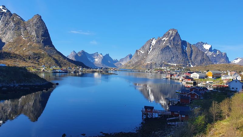
Reine looks like geography showing off with no intention of apologizing. From above, this fishing village spreads across tiny islands linked by bridges, with red cabins and boathouses standing out sharply against water, rocky edges, and steep mountain walls that make the settlement seem both exposed and incredibly organized.
The aerial perspective explains why Reine feels so distinctive on maps and photos alike. Instead of a single compact center, you get pieces of town distributed across islets, connected in a way that feels practical rather than decorative.
Harbors, docks, roads, and clusters of rorbuer fit into narrow buildable areas, while the mountains and fjord set hard boundaries that no one tries to ignore. That gives the village a crisp visual structure and very little clutter.
I think Reine is especially impressive from above because the human footprint looks modest but deliberate. Every bridge matters, every cluster has a reason, and the contrast between settlement and terrain stays clear in every frame.
It is concise, dramatic, and wonderfully legible.
10. Rothenburg ob der Tauber – Germany
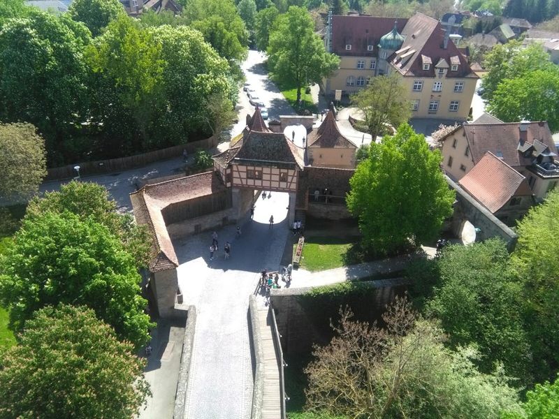
Medieval planning gets a very flattering camera angle in Rothenburg ob der Tauber. From above, the town’s walls, towers, and red roofscape create a compact historic composition that feels unusually complete, with the fortified perimeter still clearly shaping the old center instead of surviving as a few lonely leftovers.
The aerial view works so well because the town remains legible. Streets branch through the interior in a pattern that reflects age and adaptation rather than rigid symmetry, yet the enclosing walls give everything a strong outline.
You can spot gate towers, church spires, market spaces, and tightly grouped houses, all contained within a boundary that immediately tells you where the medieval town begins and ends. Outside the walls, the transition to newer development is easy to read, which makes the historic core stand out even more effectively.
I like this overhead view because it shows preservation as structure, not just decoration. Rothenburg is charming on the ground, of course, but from above it becomes a lesson in how old urban form can survive with remarkable clarity.
11. Alberobello – Italy

Regular rooftops take the day off in Alberobello, where conical trulli crowd together in a pattern that looks delightfully unlike almost anywhere else in Europe. From above, the white walls and gray stone roofs create a dense field of circles and cones, turning the town into a highly recognizable patchwork of traditional forms.
The layout matters as much as the architecture. In districts such as Rione Monti, trulli cluster along sloping streets in close succession, giving aerial images a repeating rhythm that modern buildings rarely achieve.
These structures were built with local limestone and dry stone techniques, and their compact arrangement reveals how practical vernacular building can also be visually striking. The occasional church or larger civic building interrupts the pattern just enough to keep the eye moving without breaking the town’s identity.
I find Alberobello especially entertaining from above because the roofs almost look like a town-wide agreement to ignore rectangles for a while. Yet the settlement is not whimsical.
It is historic, coherent, and impressively easy to recognize from a single glance.
12. Dubrovnik – Croatia
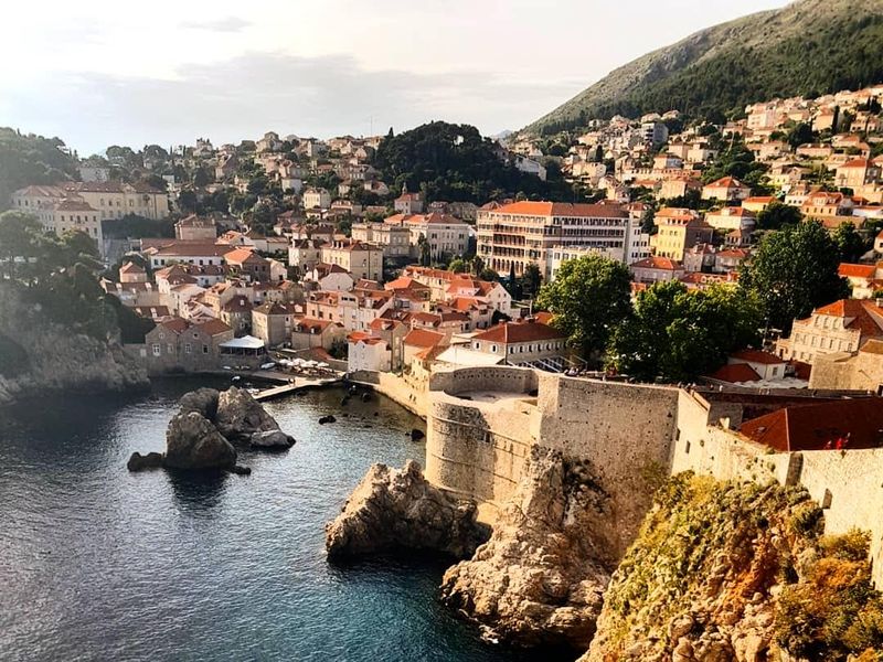
Dubrovnik arrives with walls, order, and excellent roof coordination. From above, the old town appears as a solid orange-roofed block set beside the Adriatic, with stout fortifications drawing a firm line around a dense interior of streets, squares, churches, and palaces packed into a remarkably compact footprint.
The overhead perspective makes the urban logic impossible to miss. The walls define the city’s famous silhouette, but inside them the street pattern keeps the view interesting, with the main thoroughfare cutting clearly through the center while smaller lanes branch off at useful angles.
Towers and bastions anchor the edges, and the harbor adds a strategic reminder that this was not built simply to look attractive in photographs. Every element had a role, and that practical structure still reads beautifully today.
I think Dubrovnik is most impressive from above because the whole place feels complete. Nothing about the composition looks accidental, and the contrast between the fortified old core and the open sea gives the town an especially crisp identity.
It is disciplined, historic, and camera-ready.
13. Shirakawa-go – Japan
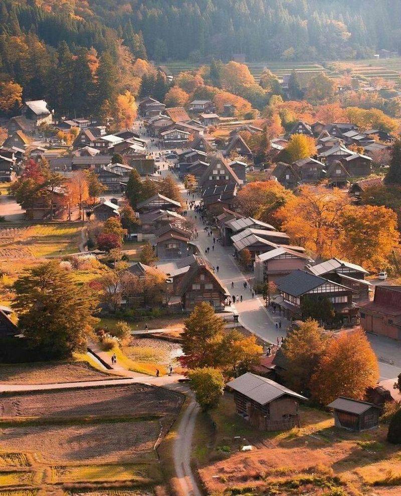
Shirakawa-go looks wonderfully sensible from above, which is part of its charm. The village sits in a mountain valley with gassho-zukuri farmhouses arranged among fields, lanes, and tree lines, and those steep thatched roofs immediately stand out as practical responses to heavy winter snow.
The aerial view gives you the full settlement pattern at once. Rather than clustering into a dense urban core, the houses are spaced with enough room for farmland and shared circulation, creating a village structure that feels agricultural first and residential second.
Roof ridges align in ways that support the buildings’ function, while the river and mountain edges define the extent of the community without needing walls or formal boundaries. It is an excellent example of how local building traditions and landscape conditions work together visibly.
I appreciate Shirakawa-go from above because it is beautiful without trying too hard. The pattern is clear, the architecture has a reason, and the setting never overpowers the human scale.
It is the kind of place that proves practicality can be deeply photogenic.
14. Zermatt – Switzerland
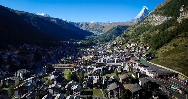
Zermatt keeps one eye on tradition and the other on logistics, and from above that balance looks excellent. The alpine town spreads in a compact pattern of chalet roofs, hotels, and service buildings, with streets and paths fitting neatly into a valley floor framed by major peaks and very little unnecessary sprawl.
The car-free center helps the layout stay visually clean. Instead of broad traffic corridors, you see a tighter grain of development, where rail access, pedestrian routes, and clustered buildings define movement through the town.
Aerial views also show how Zermatt has grown around tourism while still retaining a readable village structure, with older quarters, newer lodging zones, and open spaces all distinguishable from one another. The surrounding slopes act like firm editing marks, keeping the settlement concentrated and easy to understand.
I think Zermatt’s overhead appeal comes from its discipline. It does not compete with the mountains through size or spectacle.
Instead, it stays organized, efficient, and well composed, which turns out to be a very smart strategy when your backdrop already has global name recognition.


