Norway has no shortage of jaw-dropping scenery, but the famous spots like Trolltunga and Preikestolen get so packed in summer that you spend half the hike dodging selfie sticks. The good news?
Norway is enormous, and most of its best views have barely any visitors at all. These 11 trails offer serious mountain drama, fjord magic, and coastal wildness without the queue for the Instagram shot.
Pack your boots and prepare to have Norway almost entirely to yourself.
Ovriseggi – Vik
Vik is the kind of Norwegian village that tourists drive through without stopping. Big mistake.
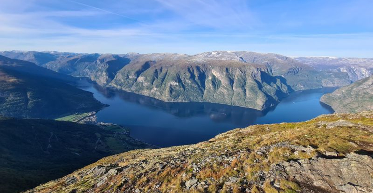
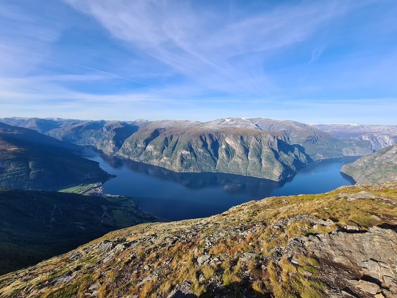
The Ovriseggi trail rises sharply above the village and delivers one of the most underrated fjord panoramas in all of Sognefjord.
The ascent is steep and honest. No one is going to pretend otherwise.
But the payoff at the top is a sweeping 360-degree view that stretches across the widest section of Sognefjord, with the Vikøyri stave church looking like a tiny toy below.
The trail is approximately 8 kilometers return with about 900 meters of climbing. Start early to catch the morning light bouncing off the water.
I once met a local farmer near the summit who told me he had walked up there every single week for thirty years. When a local keeps going back, that tells you everything you need to know about a trail.
Styvi-Bleiklindi (Royal Postal Road) – Nærøyfjord / Aurland area
For centuries, this was how mail got delivered in one of the world’s most dramatic postal routes. The Royal Postal Road between Styvi and Bleiklindi follows the edge of Nærøyfjord on a beautifully preserved stone path that dates back hundreds of years.
Unlike the more strenuous climbs on this list, this trail is relatively flat and winds through birch forest right along the fjord waterline. The views across Nærøyfjord, a UNESCO World Heritage Site, are absolutely wild.
Sheer cliffs plunge straight into the water on both sides.
The trail is about 5 kilometers one way. Most people access it by ferry from Gudvangen or Flam, which adds a genuinely lovely boat journey to the experience.
Weekdays in early June are the sweet spot before the summer rush hits. The combination of history, heritage landscape, and almost no crowds makes this one of Norway’s most quietly special walks.
Prest – Aurland
Most people in Aurland rush straight to Stegastein viewpoint and call it a day. That is their loss.
The Prest hike climbs steadily above the fjord and rewards you with views that no wooden platform can replicate.
The trail starts from the village of Aurland and gains elevation quickly, passing old farmsteads that look like they belong in a fairy tale. You will pass through meadows bursting with wildflowers in summer.
The fjord below shifts color from teal to deep navy depending on the light.
Round trip is roughly 10 kilometers with around 800 meters of elevation gain. It is well-marked and manageable for reasonably fit hikers.
I did this trail on a Tuesday in July and counted exactly four other people. Four.
Aurland is right next to the famous Flam railway, so most tourists never bother looking up the hillside. Their loss, your gain.
Fosseråsa – Geiranger
Geiranger is one of Norway’s most visited destinations, yet somehow Fosseråsa stays refreshingly quiet. While the crowds cluster at the Eagle Road viewpoint, this trail climbs the opposite hillside for a completely different angle on the fjord.
The route passes directly alongside a thundering waterfall before opening up onto grassy ledges with unobstructed views down the full length of Geirangerfjord. On a clear day you can spot the tiny white dots of cruise ships far below, which gives you a satisfying sense of scale.
The trail is around 6 kilometers return and gains about 600 meters. It starts from the village itself, so no driving to a trailhead required.
Early morning hikers will often catch low clouds rolling through the fjord below, which is genuinely spectacular. If Geiranger is on your Norway itinerary, skipping this trail would be a genuine waste of perfectly good boots.
Skålafjell (Sjethaug) – Rosendal
Rosendal sits in one of Norway’s most beautiful corners, tucked between Hardangerfjord and the Folgefonna glacier. Skålafjell, also known locally as Sjethaug, is the mountain that watches over the whole scene.
The hike starts from the village and climbs through heather moorland before reaching a broad summit plateau. From the top you get Hardangerfjord stretching in one direction and the ice cap of Folgefonna glittering in the other.
It is the kind of view that makes you stand still for an embarrassingly long time.
The trail is about 10 kilometers return with 800 meters of elevation gain. Rosendal itself is worth exploring before or after the hike.
The tiny village has a genuine baronial manor house and a rose garden that somehow feels completely out of place in the best possible way. Visitor numbers here are a fraction of what you see at nearby Hardangervidda National Park.
Hestetinden – Måløy
Hestetinden translates roughly to Horse Peak, but there is nothing slow or plodding about this hike. It charges up from the coastal town of Måløy and delivers a summit view of the Norwegian archipelago that looks like it was painted by someone who had never heard of restraint.
The trail weaves through heather and bare rock, with the Atlantic Ocean spreading endlessly to the west. On a clear day the view extends across dozens of islands and skerries scattered like crumbs across the water.
The contrast between the dark rock and the bright sea is genuinely striking.
The hike is roughly 7 kilometers return with about 500 meters of climbing. Måløy is a working fishing town with zero tourist infrastructure and zero tourist crowds, which is precisely its charm.
The local fish market is worth visiting after the hike. Fresh catch plus epic views is a combination that is very hard to beat.
Alden – Kinn / Western Norway coast
Sailors once used Alden as a navigation landmark because its distinctive rocky peak is visible from miles out at sea. Standing on top of it, you can absolutely understand why.
The mountain rises straight from the Atlantic on Kinn island with an attitude that says it knows it looks good.
The ascent involves some genuine scrambling near the summit, which adds a welcome dose of adventure to the experience. The views from the top are pure coastal Norway at its most dramatic.
Open ocean in every direction, with the Norwegian coastline curving away to the north and south.
The island is reached by ferry from Florø, which takes about 30 minutes. The full hike is around 5 kilometers with 400 meters of elevation gain.
Kinn also has a medieval church near the ferry dock that is worth a quick visit. Few tourists make the trip, which means you often have the entire mountain to yourself on weekdays.
Rødøyløva – Rødøy, Helgeland
The name Rødøyløva means the Lion of Rødøy, and once you see the mountain’s profile from the sea, the name makes complete sense. This rocky peak on a small Helgeland island looks like it is crouching, ready to pounce across the archipelago.
Getting there is half the fun. You take a ferry from the mainland to the tiny island of Rødøy, where the local population is small enough that everyone waves at strangers.
The hike to the summit is short but steep, covering about 3 kilometers return with 400 meters of gain.
At the top, the Helgeland archipelago unfolds around you in every direction. Hundreds of islands, the famous Seven Sisters mountain range on the mainland, and the open sea beyond.
This is Helgeland at its most cinematic. Hardly anyone outside Norway knows this place exists, which is either a well-kept secret or a genuine oversight by the global hiking community.
Torghatten – Brønnøysund
There is a mountain in Norway with a hole straight through it. Not a small hole.
A tunnel 160 meters long, 35 meters wide, and 20 meters high, punched clean through solid rock by ancient waves during the last ice age. Torghatten is not subtle.
The hike up to the hole takes about 20 minutes from the parking area. It is short, accessible, and absolutely worth every step.
Walking through the tunnel and emerging on the other side with views of the Helgeland archipelago is one of those experiences that stays with you.
After doing the tunnel, ambitious hikers can continue to the actual summit for even broader views. The total loop with summit is about 4 kilometers.
Torghatten is one of Helgeland’s most known spots, but compared to southern Norway’s tourist magnets it remains pleasantly uncrowded. The ferry from Brønnøysund to the island is a short ride and runs regularly throughout the day.
Dronningruta – Nyksund and Stø, Vesterålen
Dronningruta, the Queen’s Route, connects the ghost-village-turned-artist-colony of Nyksund with the fishing village of Stø along one of the wildest stretches of coastline in Vesterålen. It earned its royal name when Queen Sonja of Norway walked it herself, which is a solid endorsement.
The trail covers about 11 kilometers one way and hugs the coast the entire time. Rocky headlands, hidden coves, and views out to the open Norwegian Sea keep things interesting for every single kilometer.
In summer, the midnight sun turns the whole landscape gold at 11pm.
Nyksund is one of those places that was completely abandoned in the 1970s and slowly brought back to life by artists and adventurers. It now has a small cafe and some guesthouses.
Starting the hike from Nyksund and finishing in Stø makes logistical sense if you arrange a pickup. This trail consistently ranks as one of Norway’s finest coastal walks, yet somehow stays under the radar.
Dønnamannen – Dønna, Helgeland
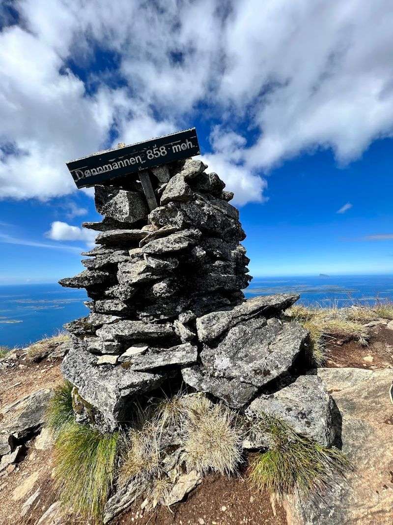
Dønna island sits in the middle of the Helgeland archipelago like it owns the place. And Dønnamannen, the island’s highest peak, sits at the top of Dønna with the same energy.
The name means the Man of Dønna, and the mountain has a presence that justifies the title.
The trail to the summit is about 6 kilometers return and gains around 600 meters. The path starts near the island’s small ferry dock and winds through open moorland before reaching the rocky summit.
Views from the top include the Seven Sisters, Lovund, Træna, and on a very clear day, the Lofoten peaks far to the north.
Dønna has a population of around 1,200 people and sees very few visiting hikers. The island also has one of Norway’s oldest medieval stone churches, dating back to the 12th century.
Combining the mountain hike with a visit to the church makes for a genuinely full and satisfying day out.


