Not every great travel destination looks like a postcard from paradise. Some of the most stunning places in the United States are also the strangest, the spookiest, or just plain weird in the best possible way.
From ghost towns frozen in time to alien-looking landscapes that make you question what planet you are on, these spots prove that beauty does not always play by the rules. If your idea of a perfect trip involves a little mystery and a lot of wow, this list was made for you.
Salton Sea, California
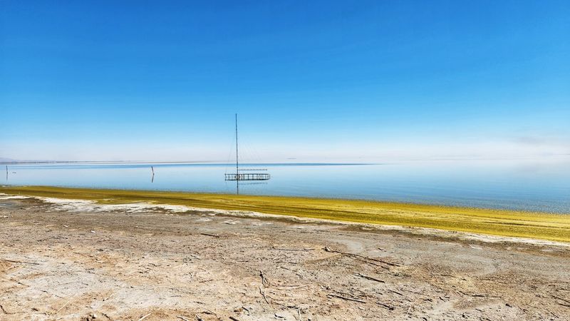
California’s largest lake by surface area is also one of its most unsettling places. The Salton Sea was accidentally created in 1905 when an irrigation canal broke and flooded a desert basin for two straight years.
Nobody planned it. Nobody stopped it either.
Today, the shoreline is coated in a crunchy layer of fish bones and barnacle shells. The water is saltier than the Pacific Ocean.
Pelicans still flock here by the thousands, which is somehow both beautiful and deeply strange at the same time.
Abandoned resorts and boat ramps from the 1960s tourism boom dot the edges of the lake like a faded dream. Sunset here turns the whole scene golden and pink, making it look almost magical despite the smell.
Go for the weirdness, stay for the surprisingly gorgeous sky.
Carlsbad Caverns National Park, New Mexico
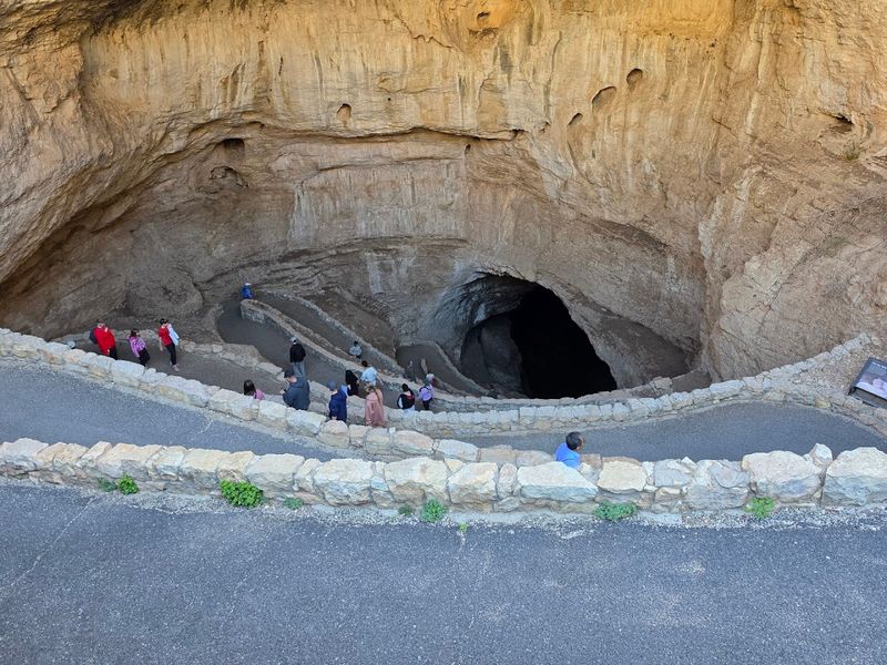
Every evening from spring through fall, nearly half a million Mexican free-tailed bats spiral out of Carlsbad Caverns at dusk in a living tornado of wings. It lasts about two hours.
Rangers hold a free program at the amphitheater so you can watch without getting dive-bombed.
Below ground, the caves hold rooms so large that the U.S. Capitol building could fit inside with room to spare.
The Big Room stretches over 4,000 feet long and features formations with names like Witch’s Finger and the Bottomless Pit, which is not actually bottomless but still deeply dramatic.
The caverns stay at a steady 56 degrees Fahrenheit year-round, so pack a jacket even in July. Self-guided tours let you explore at your own pace.
The elevator ride down 750 feet is smooth, but the natural entrance walk is the more adventurous option for those who enjoy a good descent.
Bonneville Salt Flats, Utah
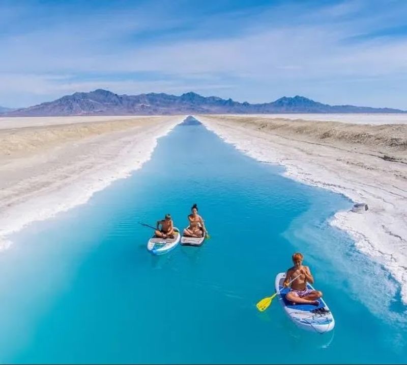
Standing on the Bonneville Salt Flats feels like standing inside a giant blank page. The ground is white, the sky is blue, and the horizon line barely exists.
It covers over 30,000 acres and is the remnant of an ancient lake called Lake Bonneville that dried up roughly 13,000 years ago.
Speed junkies love this place. Cars have been setting land speed records here since 1914, and the current record tops 760 miles per hour.
The surface is so flat and so long that Earth’s curvature becomes visible to the naked eye, which is a fact that never gets old.
After rainfall, the flats turn into a perfect mirror reflecting the sky above, creating photos that look completely unreal. Visit between August and October for the best conditions.
The flats are free to access and located just off Interstate 80, making it one of the easiest detours you will ever take.
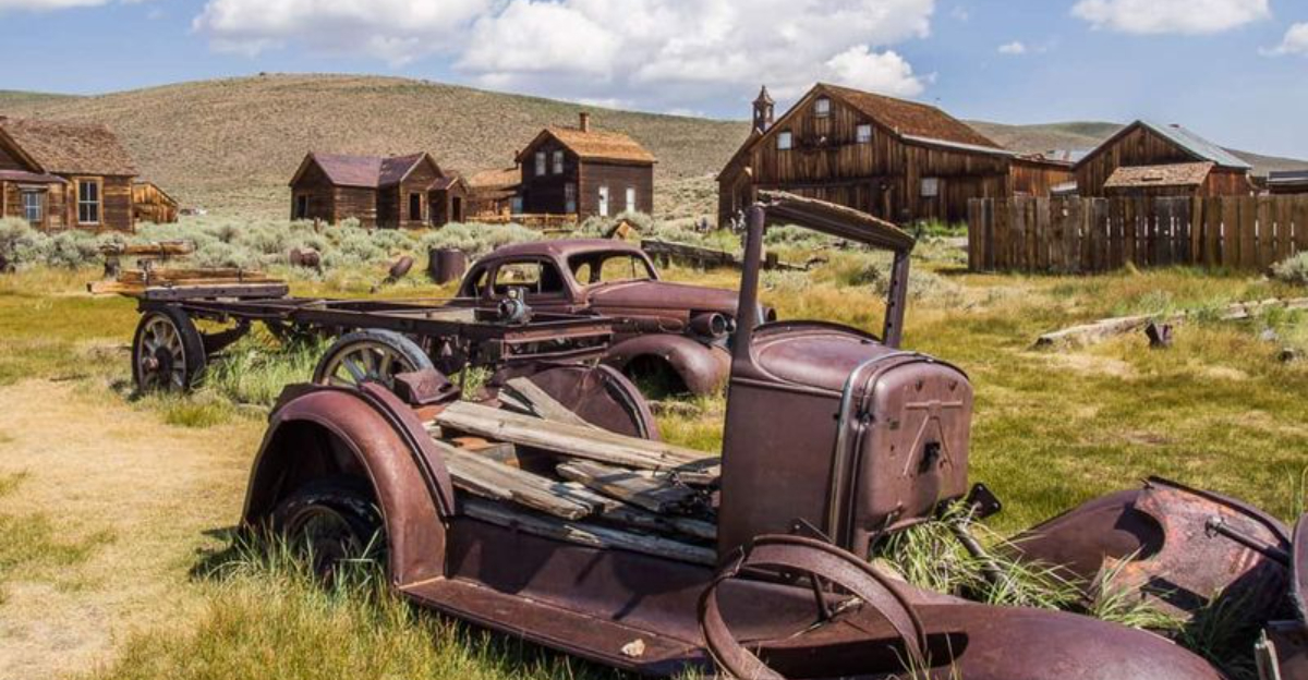
Bodie State Historic Park, California
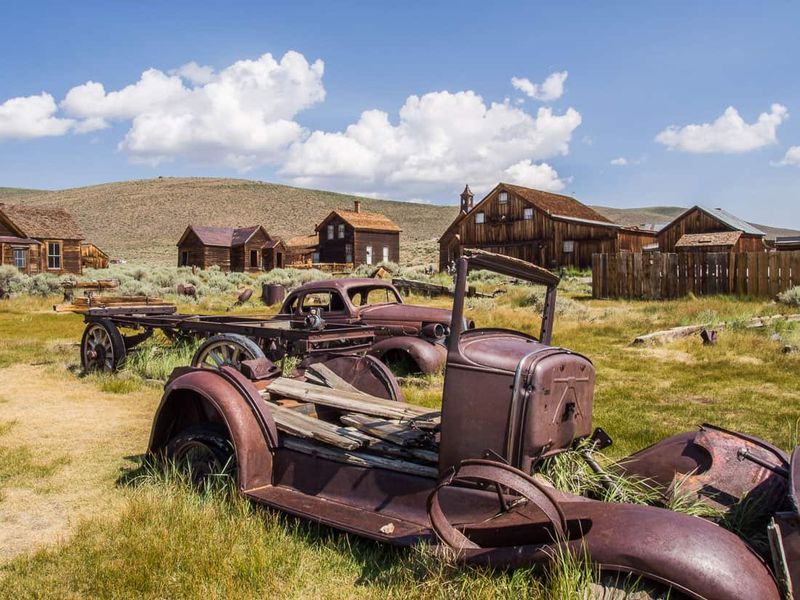
Bodie is a ghost town that actually stayed ghostly. No gift shops, no costumed actors, just hundreds of crumbling buildings left exactly as they were when residents fled in the early 1900s.
The state of California calls it “arrested decay,” which sounds like a crime but is actually a preservation policy.
Inside the old homes, dishes still sit on tables and children’s toys collect dust on shelves. It genuinely feels like everyone just vanished mid-breakfast.
I visited on a windy afternoon and the creaking doors did not help my nerves one bit.
Bodie sits at 8,375 feet in the Eastern Sierra, so summers are short and winters are brutal. The park is open year-round, but snow can close the road from November through spring.
Come prepared with layers, sturdy shoes, and a healthy respect for eerie silence.
Mono Lake, California
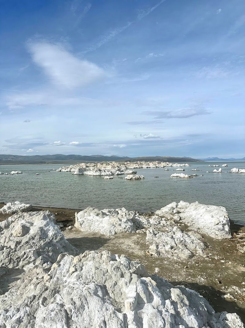
Mono Lake is three times saltier than the ocean and has no outlet, which means water only leaves through evaporation. That quirky chemistry created something spectacular: towering columns of limestone called tufa, which look like alien stalagmites erupting from the water’s edge.
These tufa towers formed underwater over thousands of years but became exposed when the city of Los Angeles began diverting water from the lake’s tributary streams in the 1940s. The lake dropped 45 feet.
A long legal battle eventually saved it, and water levels have slowly been recovering since 1994.
The brine shrimp population here supports over two million migratory birds each year, including the eared grebe and California gull. Kayaking among the tufa towers is one of the strangest and most peaceful experiences available in the state.
The South Tufa Area has a short trail perfect for first-time visitors who want the full alien-landscape effect.
Mammoth Cave National Park, Kentucky
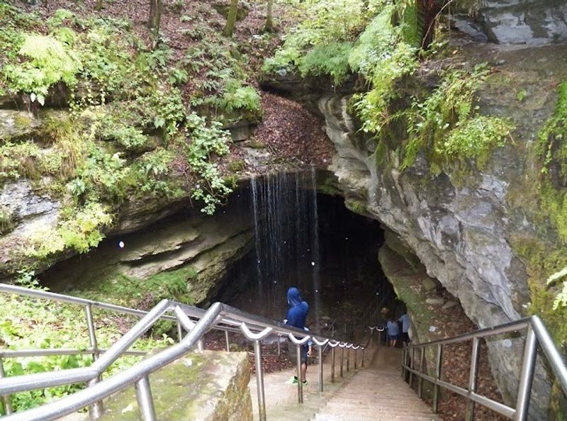
With over 400 miles of surveyed passageways, Mammoth Cave holds the title of the longest known cave system on Earth. And geologists believe there are still more sections waiting to be discovered, which is either exciting or terrifying depending on your relationship with dark enclosed spaces.
The cave has been used for a surprising number of things throughout history. Native Americans mined it for minerals 4,000 years ago.
During the War of 1812, saltpeter for gunpowder was harvested here. In the 1840s, tuberculosis patients actually lived inside the cave for months because doctors believed the cool air would help them.
It did not.
Today, the park offers over a dozen guided tours ranging from stroller-friendly strolls to full-on crawling expeditions through tight passages. The Historic Tour is the most popular and covers the cave’s long human history.
Book tickets in advance because tours fill up fast, especially in summer months.
Thor’s Well, Oregon
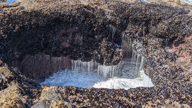
Thor’s Well is a sinkhole in the Oregon coast’s basalt rock that appears to drain the entire Pacific Ocean. It does not actually do that, but during high tide and heavy surf, water surges in, shoots upward, and then gets sucked back down in a roaring spiral that is absolutely wild to watch.
The spot sits within Cape Perpetua Scenic Area near Yachats, and the parking lot is just a short walk from the action. Go during a king tide or a storm swell for maximum drama.
Rangers recommend watching from a safe distance because the rocks get slippery and rogue waves are a real thing here.
Photographers especially love Thor’s Well around sunset when the light turns orange and the spray catches the glow like scattered sparks. Long-exposure shots turn the water into silky ribbons of motion.
Wear waterproof shoes, bring a rain jacket, and accept that you will probably get a little wet anyway.
Great Sand Dunes National Park, Colorado
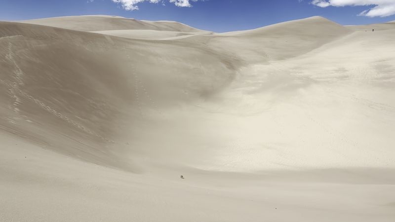
Colorado is famous for mountains, skiing, and craft beer. It is not typically where you expect to find North America’s tallest sand dunes, yet here they are, rising 750 feet from the San Luis Valley floor like a geographic punchline with incredible views.
The dunes formed over thousands of years as wind carried sand from the valley and deposited it against the mountain range. Medano Creek runs along the base of the dunes from spring through early summer, creating a shallow wading stream that is shockingly fun for all ages.
The creek actually produces surge flow, a wave-like pulse caused by sand movement underwater.
Sandboarding and sand sledding are allowed and rentals are available in the nearby town of Mosca. Hiking up the dunes is harder than it looks since every step sinks a little.
Go at sunrise when the light hits the ridgelines and the shadows create shapes that look almost painted. Temperatures swing wildly, so layer up.
Badlands National Park, South Dakota
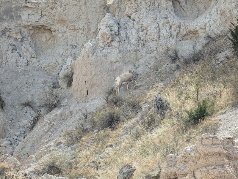
The Lakota people called this place “mako sica,” meaning bad lands, and French fur trappers agreed, calling it “les mauvaises terres.” Both groups were warning travelers about the harsh terrain. Modern visitors, however, show up specifically for those jagged spires and painted rock layers that stretch across the horizon like a fever dream.
The Badlands erode about an inch per year, meaning the landscape is literally changing while you visit. Fossils of ancient rhinos, three-toed horses, and saber-toothed cats have been found here.
The park has an active paleontology program and sometimes visitors get to watch real excavations in progress.
Bison roam freely throughout the park, and spotting them from your car is basically guaranteed. The Badlands Loop Road covers 39 miles and hits all the major overlooks without requiring any strenuous hiking.
Sunsets here are legendary, painting the formations in deep reds and purples that make even skeptics reach for their cameras.
Craters of the Moon National Monument and Preserve, Idaho
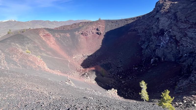
NASA actually sent Apollo astronauts to train here before the moon missions. When you see the endless black lava fields, twisted volcanic formations, and cinder cones rising from the Snake River Plain, the reasoning becomes immediately obvious.
This place does not look like Idaho. It barely looks like Earth.
The monument covers over 750,000 acres and preserves one of the best examples of a young volcanic landscape in the continental United States. The last major eruption happened about 2,000 years ago, which in geological terms is basically last Tuesday.
Scientists believe the volcanic system is still active and will erupt again.
Seven miles of paved road loop through the monument with stops at lava tubes, spatter cones, and tree molds where ancient trees burned and left hollow impressions in the rock. Bring a flashlight for the lava tube caves.
The visitor center has maps and ranger programs that make the geology surprisingly easy to understand.
Valley of Fire State Park, Nevada
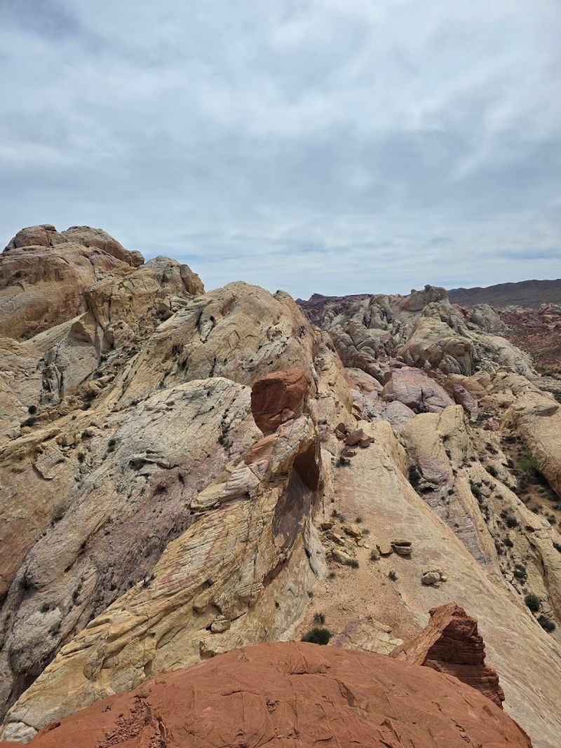
Nevada’s oldest state park earns its dramatic name every single day. The sandstone formations here glow a deep, burning red in direct sunlight, especially in the late afternoon when the whole valley seems to catch fire without a single flame.
It is genuinely one of the most photogenic places in the American Southwest.
The rocks are 150 million years old and contain some of the best preserved petroglyphs in the region. Ancient Ancestral Puebloans carved images of bighorn sheep, spirals, and human figures into the stone.
Mouse’s Tank Trail is a short, easy hike that passes dozens of these carvings along a sandy wash.
Valley of Fire sits about an hour northeast of Las Vegas, making it an easy day trip from the Strip. The park is open year-round, but summer temperatures regularly exceed 110 degrees Fahrenheit.
Go in spring or fall for comfortable hiking and the best light for photography. Camping is available at two campgrounds inside the park.
Dry Tortugas National Park, Florida
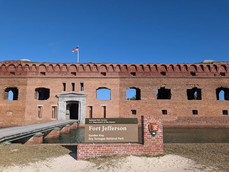
Getting to Dry Tortugas requires a 70-mile ferry ride or seaplane trip into the Gulf of Mexico, which means the crowds stay thin and the water stays ridiculously clear. The park is 99 percent water, with seven small islands scattered across a shallow turquoise sea that looks more like the Bahamas than Florida.
The star of the show is Fort Jefferson, a 19th-century military fortress built on Garden Key that was never actually finished. Construction started in 1846 and went on for 30 years before engineers realized the island’s coral foundation could not support the weight.
It is the largest masonry structure in the Western Hemisphere and it is slowly sinking.
Snorkeling around the fort walls reveals coral reefs, sea turtles, and hundreds of colorful fish species. The overnight campground on Garden Key is one of the most remote camping spots in the entire national park system.
Reservations go fast, so plan several months ahead if you want a spot.
Petrified Forest National Park, Arizona
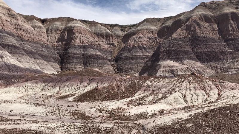
About 225 million years ago, a massive forest of tall conifer-like trees stood in what is now northeastern Arizona. Volcanic ash buried the fallen logs, groundwater flooded the area with silica, and over millions of years the wood was replaced crystal by crystal with quartz.
The result is a forest of stone logs scattered across a painted desert.
The colors inside the petrified wood are spectacular. Cross-sections reveal rings of deep purple, red, orange, and yellow created by different minerals during the fossilization process.
Some logs are over six feet in diameter and stretch nearly 200 feet long. It sounds impossible until you are standing right next to one.
The park also contains thousands of petroglyphs and the ruins of ancient Puebloan villages. Removing even a pebble of petrified wood is illegal and carries a serious fine.
Rangers say the park receives packages in the mail almost weekly from people returning stolen wood, sometimes with guilt-ridden notes attached. True story.
The Wave, Arizona
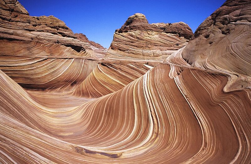
Only 64 people per day are allowed to visit The Wave, and half of those permits are awarded by lottery months in advance. The other half go to an in-person lottery held the morning before.
Getting a permit feels like winning a small, geologically stunning lottery, and the hike to reach it is worth every step of the three-mile trek across open slickrock.
The formation sits inside Vermilion Cliffs National Monument near the Utah-Arizona border. The swirling sandstone layers were created 190 million years ago from ancient sand dunes that hardened and then eroded into flowing curves.
No two sections look the same, and the colors shift dramatically depending on the time of day.
There is no marked trail, no shade, and no water source along the route. Hikers must carry their own water and navigate using a topographic map provided with the permit.
Go in spring or fall to avoid dangerous heat. The solitude and scenery together create something that is genuinely hard to describe.
Spiral Jetty, Utah
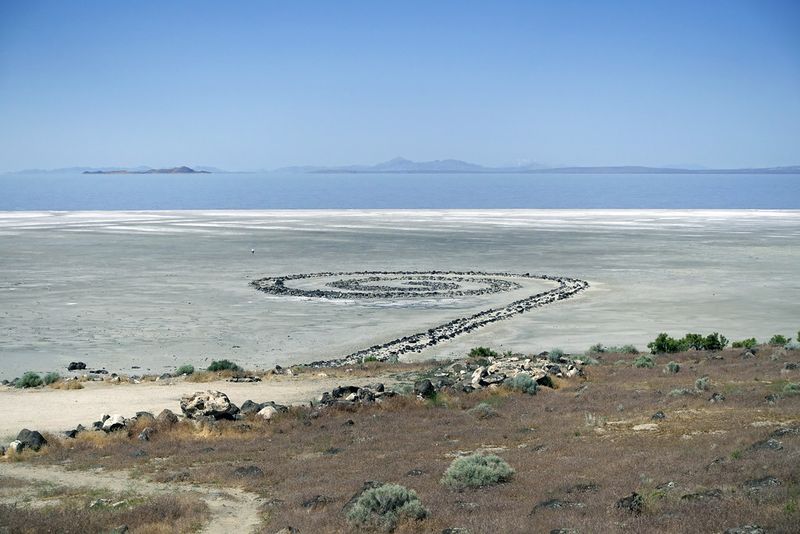
Robert Smithson built Spiral Jetty in 1970 using 6,650 tons of black basalt rock arranged in a counterclockwise coil extending 1,500 feet into the Great Salt Lake. He called it earthwork art.
Most people call it one of the strangest and most compelling things they have ever seen in person.
The jetty was submerged for most of the 1980s and 1990s as lake levels rose, then reemerged in the early 2000s. Today it sits in shallow water that turns pink and red due to salt-loving algae and bacteria.
The contrast between the black rocks and the rosy water is genuinely surreal and completely natural.
Getting there requires a 15-mile drive on a dirt road near Rozel Point, so a high-clearance vehicle is recommended. There are no facilities, no entrance fees, and no crowds most days.
The Dia Art Foundation maintains the site. Bring water, sunscreen, and a good amount of patience for the bumpy road in.


