Earth has a talent for making ordinary geography look completely implausible. Some of these pits were carved by water, some by mining, and one by a gas fire that has outlasted disco, cassettes, and several map redesigns.
What makes them fascinating is not just their strange appearance, but the history, engineering, geology, and scientific debates packed into each one. Keep going and you will get a grounded tour of places that look wildly unreal while telling very real stories about climate, industry, exploration, and the long habit humans have of digging, naming, and trying to explain the planet beneath our feet.
1. Darvaza Gas Crater, Turkmenistan – The “Door to Hell”
Few places on Earth look like geology hired a special effects team. The Darvaza Gas Crater formed in the early 1970s when Soviet drilling disturbed a gas-filled underground cavity, causing the ground to collapse into a broad pit in the Karakum Desert.
Engineers reportedly ignited the escaping gas to reduce methane release, expecting a short burn. Instead, the crater kept burning for decades, growing into a global curiosity roughly 60 meters across and about 20 meters deep.
Its nickname, “Door to Hell,” did most of the publicity work, but the real story is about energy exploration and unintended outcomes. Turkmenistan has periodically discussed extinguishing it, yet the crater remains a landmark where industrial ambition, desert isolation, and plain bad forecasting combined into one of the planet’s strangest glowing holes.
2. Great Blue Hole, Belize – Ocean’s Perfect Circle
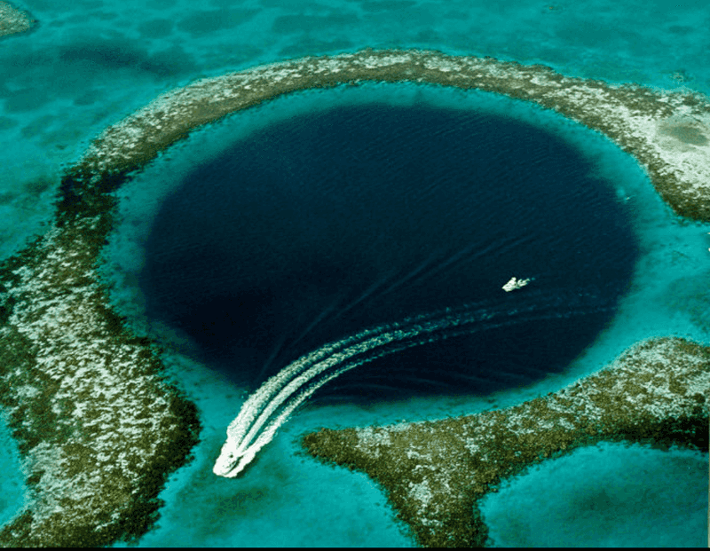
From the sky, this place looks less like a sinkhole and more like a giant punctuation mark dropped into the Caribbean. The Great Blue Hole off Belize is a marine sinkhole about 124 meters deep, famous for its near-perfect circular shape and sharp contrast with the surrounding reef.
Its story began when lower sea levels left limestone caves exposed, allowing stalactites to form. As seas rose and cave roofs collapsed, the submerged hole took shape over many thousands of years, with some estimates tracing major formation phases back roughly 153,000 years.
Jacques Cousteau helped turn it into a modern icon in the 1970s, and divers still visit to examine its geological layers. Beyond the postcard view, it offers evidence of ancient cave systems, changing sea levels, and the steady ability of water and time to redraw entire landscapes with ruthless precision.
3. Bingham Canyon Mine, USA – A Man-Made Giant
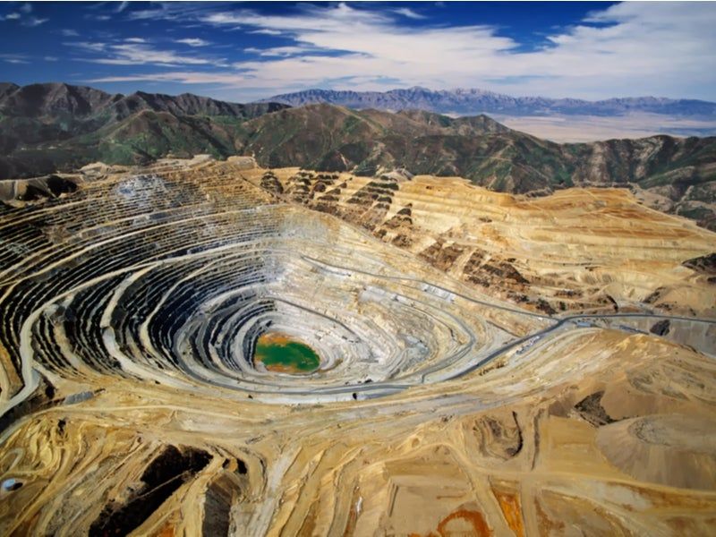
Human beings rarely do subtle when copper is involved. Bingham Canyon Mine in Utah began large-scale operations in 1906 and expanded into one of the biggest open-pit mines on Earth, stretching about 2.5 miles across and descending to extraordinary depth.
Its terraced spiral walls give it that unreal, almost computer-generated look, but every bench records a century of industrial planning, blasting, hauling, and ore processing. The mine has produced huge quantities of copper, plus gold, silver, and molybdenum, making it a major engine of American mining history.
It is often described as visible from space, which sounds like bragging until you see the scale. A major landslide in 2013 changed parts of the operation without ending its significance, and the site remains a vivid reminder that some of the planet’s strangest pits were not accidents of nature at all.
4. Xiaozhai Tiankeng, China – The Heavenly Pit
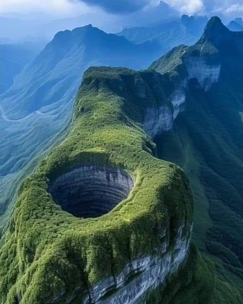
This sinkhole sounds mythical, but the measurements are what really unsettle you. Xiaozhai Tiankeng in Chongqing, China, is widely recognized as the world’s largest and deepest tiankeng, reaching around 662 meters deep with immense vertical walls and a double-nested structure.
It formed in karst terrain where water gradually dissolved limestone and weakened underground spaces until collapse took over. The result is so large that it contains its own internal ecological zones, including dense vegetation and a substantial underground river system connected to caves below.
Chinese explorers and scientists have studied it for decades, documenting both geological processes and the species living within its enclosed environment. The phrase “Heavenly Pit” sounds poetic, yet this is a case where the name undersells the engineering-grade scale of nature’s work, proving that erosion can produce architecture more startling than almost anything humans draft on paper.
5. Kimberley Big Hole, South Africa – Diamond Legacy
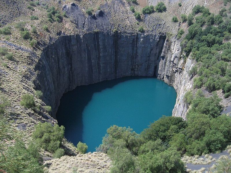
Nothing says nineteenth-century ambition quite like thousands of people digging the same patch of ground by hand. The Kimberley Big Hole in South Africa grew out of the diamond rush beginning in 1871, when prospectors converged on the area after major gem discoveries.
What followed was intense manual excavation on a scale that still seems improbable. Often described as one of the largest hand-dug holes in the world, it reached over 200 meters deep before later flooding created the water-filled view many visitors know today.
The pit helped build fortunes, accelerated corporate consolidation, and fed the rise of De Beers, turning Kimberley into a center of global diamond history. It also reveals how quickly boomtown economics can reshape land, labor, and infrastructure, leaving behind a crater that looks ancient at first glance but is actually a monument to industrial-era urgency.
6. Monticello Dam Glory Hole, USA – Nature Meets Engineering
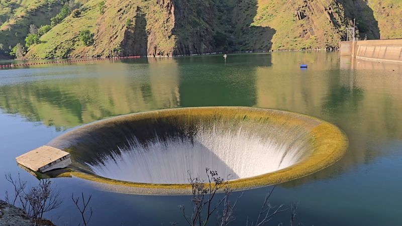
Engineers occasionally create structures that look like they came from speculative fiction by accident. The Monticello Dam Glory Hole in California is a circular spillway at Lake Berryessa, designed to divert excess water when reservoir levels rise beyond safe operating limits.
Completed in the 1950s as part of the Solano Project, the dam supports irrigation, water supply, and flood control. The spillway itself is about 72 feet across at the rim and channels overflow through a vertical shaft into a tunnel, preventing dangerous overtopping.
When active, it attracts attention because the water seems to vanish into a perfectly round opening, which is not a common everyday sight unless your neighborhood includes cinematic hydrology. Despite the nickname, it is a serious piece of infrastructure, showing how mid-century dam design combined utility, scale, and geometry into one of America’s most surreal engineered pits.
7. Dean’s Blue Hole, Bahamas – A Diver’s Dream
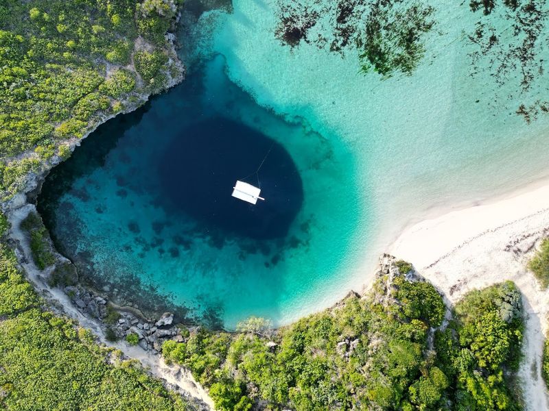
At first glance, the water seems to have misplaced an entire section of seabed. Dean’s Blue Hole on Long Island in the Bahamas is the world’s deepest known blue hole, descending to about 202 meters in a shallow bay bordered by much lighter water.
Its opening appears modest from above, then widens after a relatively short descent, which helps explain its outsized reputation among divers and researchers. Blue holes form through limestone dissolution during periods of lower sea level, followed by flooding as oceans rose and underground cavities connected with coastal waters.
Dean’s Blue Hole became especially well known through freediving competitions, though its scientific value is just as compelling. The site offers clues about sea-level change, cave formation, and marine conditions at depth, all while presenting the kind of visual contrast that makes even seasoned travelers pause and double-check that nature really approved this design.
8. Batagaika Crater, Russia – The “Gateway to the Underworld”
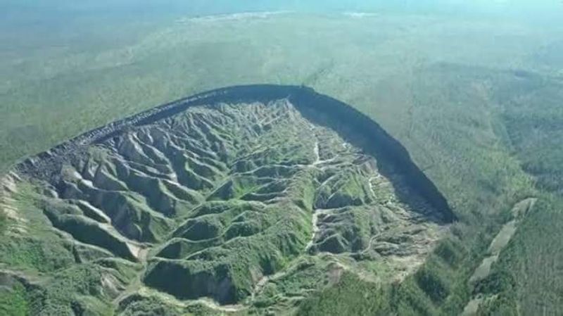
This crater looks like the Earth opened a historical archive and forgot to close it. Batagaika Crater in eastern Siberia is a vast thermokarst depression created as permafrost thaws, causing ground collapse and exposing long-buried layers of soil, ice, and organic material.
Sometimes nicknamed the “Gateway to the Underworld,” it has expanded for decades and continues to draw scientific interest because its walls reveal environmental records from the distant past. Researchers have identified ancient plant material, old forest remains, and other evidence useful for studying Arctic climate shifts across long timescales.
Unlike a classic impact crater, Batagaika is tied to warming temperatures and landscape instability, making it both visually strange and scientifically urgent. It reminds you that some of the planet’s most otherworldly holes are not static landmarks but active indicators, recording present change while uncovering evidence from eras when mammoths still counted as current events.
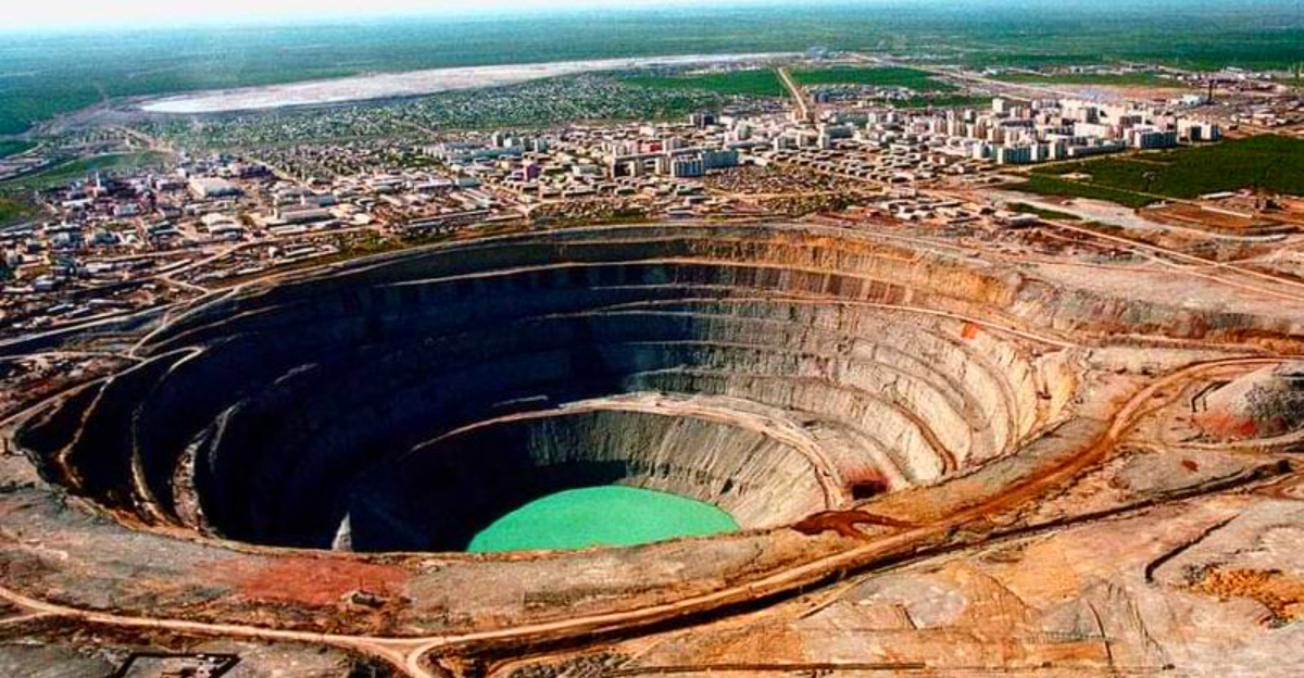
9. Mirny Diamond Mine, Russia – A Frozen Spiral
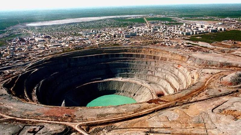
Few mining sites look this determined to intimidate aircraft and maps alike. Mirny Mine in Siberia began operations after diamonds were discovered in Yakutia in the 1950s, and it grew into one of the largest excavated pits in the world, around 525 meters deep and roughly 1,200 meters across.
The Soviet Union treated the site as strategically important, since industrial diamonds and gem production mattered economically and symbolically. Open-pit extraction eventually became impractical, but underground mining continued, and the vast spiral cavity remained as a striking record of Soviet-era resource development.
Stories about helicopters avoiding the pit because of air currents helped build its legend, though the mine hardly needed extra drama. In plain historical terms, Mirny shows how remote regions were transformed by twentieth-century extraction, infrastructure, and state ambition, leaving behind a frozen landscape where engineering scale and political priorities are carved directly into the ground.
10. Devil’s Sinkhole, USA – A Vertical Mystery
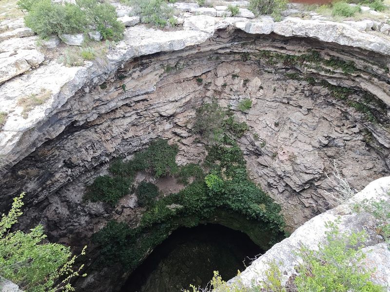
Texas has many large things, but this one drops straight into the conversation. Devil’s Sinkhole near Rocksprings is a deep vertical cavern in limestone country, formed through karst processes that dissolved rock below the surface until collapse created a dramatic shaft.
The opening measures about 40 to 60 feet across, while the cavern below expands significantly, reaching depths well over 300 feet. It is best known as habitat for millions of Mexican free-tailed bats, which makes the site important not just geologically but ecologically.
Protected as a State Natural Area, it is visited through guided tours that focus on conservation and natural history rather than supernatural branding, despite the name’s enthusiasm for marketing. The sinkhole offers a useful reminder that mysterious-looking places often have very practical scientific value, from tracking karst formation to understanding how large bat populations fit into regional ecosystems and agriculture.
11. Chuquicamata Mine, Chile – Desert Giant
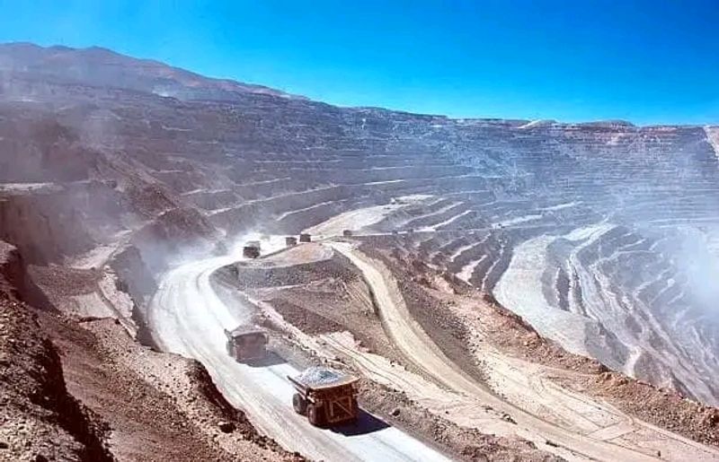
The Atacama Desert already looks unconventional, so adding one of the world’s largest open pits feels almost unfair. Chuquicamata in northern Chile is a colossal copper mine whose modern industrial development accelerated in the early twentieth century, eventually making it central to global copper production.
Its stepped walls and vast footprint create that unmistakable machine-cut geometry, while the surrounding desert strips away visual clutter and leaves the scale impossible to ignore. For decades, the mine shaped labor history, company housing, transportation networks, and Chile’s broader economic story through copper exports and state involvement.
Open-pit operations later shifted toward underground mining plans as extraction conditions changed, but Chuquicamata remains a landmark of industrial ambition in extreme terrain. It also shows how mining landscapes become cultural landscapes, carrying stories about workers, technology, national revenue, and the global appetite for electrical metal long before most people thought about where their wiring began.
12. Sima Humboldt, Venezuela – Lost World Vibes
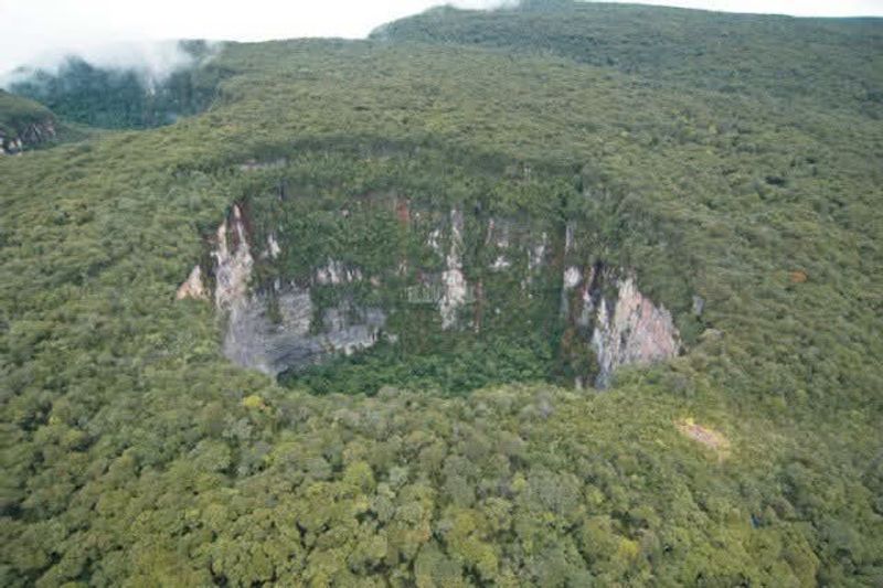
Even by tepui standards, this sinkhole seems committed to being difficult to believe. Sima Humboldt, part of the Sarisarinama system in Venezuela, is a giant collapse feature in sandstone, not limestone, which already makes it geologically unusual and scientifically important.
Its upper rim spans roughly 350 meters, and the base broadens even more, creating an isolated interior environment with species adapted to conditions inside the pit. Because these sinkholes sit atop a table mountain, their very location challenged assumptions about how such large collapse features could form in sandstone terrain.
Explorers and researchers documented distinctive plant communities within the sinkhole, adding a biological story to the geological one. The “lost world” reputation comes naturally, but the more interesting point is that Sima Humboldt demonstrates how isolation, elevation, and erosion can combine into a natural laboratory where evolution and landform history share the same astonishing address.
13. Baatara Gorge Waterfall, Lebanon – A Hole Through Time
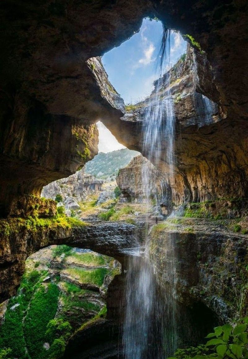
Some landscapes look designed specifically to embarrass ordinary postcards. Baatara Gorge Waterfall in Lebanon sends water through a huge limestone opening into a cave system below, creating one of the most unusual natural drop-through scenes in the eastern Mediterranean.
The site lies in the Mount Lebanon Trail region and is tied to karst processes that dissolved rock and expanded underground voids over long periods. Discovered by modern cavers in the twentieth century but known locally earlier, it became famous for its dramatic bridge-like rock formations spanning the shaft.
What makes it especially compelling is not just the vertical opening, but the visible relationship between surface water and hidden subterranean routes. Scientists have used dye tracing to study connections within the cave network, while travelers mostly stand there reconsidering what counts as a normal waterfall.
It is geology behaving with complete confidence and very little interest in subtlety.


