Some trails make you work for the good parts, but this one starts teasing you almost immediately with shaded curves, rolling climbs, and the kind of forest quiet that makes your phone feel slightly embarrassed. The surprise is how big it feels once you are inside, because a simple morning outing can suddenly become a choose-your-own-adventure through more than 30 miles of marked routes.
Keep reading and you will find the exact trailhead, the best reasons bikers grin here, why hikers should not skip it, and the small planning details that make the day smoother. I came for a walk in the woods and ended up understanding why this corner of Northern Michigan keeps pulling people back.
The Trailhead That Starts the Whole Adventure

The main access point I used was the Glacial Hills Pathway and Natural Area Trailhead at 3169 Eckhardt Rd, Bellaire, MI 49615, just outside the village in Antrim County, Michigan, United States.
That address matters because this is not a tiny roadside stroll with one obvious loop. The system spreads across roughly 765 to more than 800 acres, depending on the mapped boundary you see, and the first trail map immediately hints that your casual outing may need a snack plan.
I like that the Eckhardt Road trailhead feels practical rather than fussy, with parking, signage, and quick access into the woods. The posted hours run 5 AM to 10 PM daily, which gives early risers and golden-hour wanderers plenty of room to play politely.
Once you pass the map, the forest takes over fast. The next surprise is how carefully the routes are designed, because the hills feel playful without becoming a punishment parade.
A Forest Built By Ice And Time

The hills here have a backstory written by retreating glaciers, which explains the rolling terrain that gives the pathway its name. You feel that ancient shaping in your calves, but thankfully not in a melodramatic way.
Instead of one long climb followed by regret, the land rises and dips in steady waves. Some high points sit more than 400 feet above the trailheads, and that elevation change keeps the route interesting even when the forest seems calm.
I noticed the ground changing often, with hardwood shade, conifers, leaf litter, and sandy patches trading places along the way. It never feels overbuilt, yet the trail surface shows thoughtful work, especially on the bends and gentle grades.
That mix of natural landform and careful design is the secret sauce. After the first few rollers, you start to understand why bikers talk about flow here, and that flow becomes the next part of the story.
Why Mountain Bikers Keep Smiling Here

The mountain biking at Glacial Hills Pathway has a reputation for being fast, flowy, and friendly to a wide range of riders. That description sounds simple until you see how many turns and rollers have been tucked into the woods.
I am not here to pretend every route is extreme, because many trails are more cross-country fun than technical test. That is actually part of the appeal, especially if you want speed, rhythm, shade, and choices without needing a stunt checklist.
Beginners can find forgiving loops, while stronger riders can build longer routes and keep momentum through berms, climbs, and quick descents. The system is generally bi-directional, so I stayed alert around blind corners and treated every bend like someone cheerful might be arriving.
The best rides here are not about showing off. They are about linking miles until the forest starts feeling like a puzzle, and hikers get their own reward once the trail pace slows down.
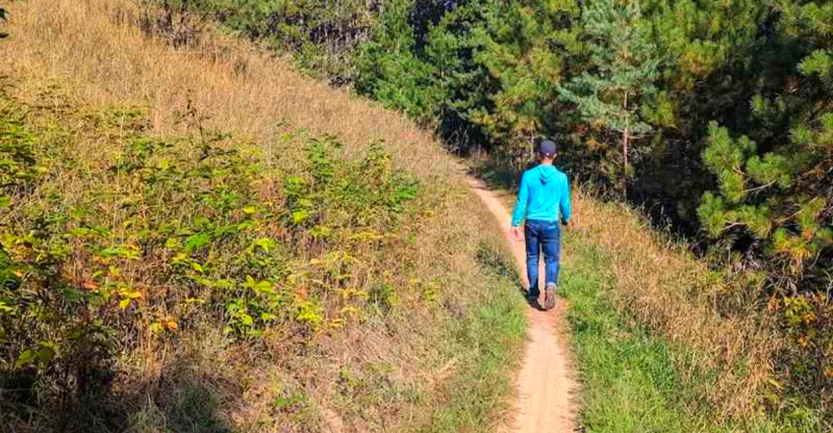
Hiking Feels Bigger Than The Map Suggests

On foot, the trail system feels less like a workout machine and more like a long conversation with the woods. The marked intersections let you choose shorter rambles or longer loops, which is handy when your legs start voting for lunch.
I liked how the routes climbed and curved without turning the hike into a grim uphill bargain. You get enough ups, downs, twists, and texture to stay engaged, while the shade keeps summer walks surprisingly comfortable.
Trail markings are one of the quiet heroes here. With more than 31 miles available, I still took a photo of the map before starting, because confidence is wonderful and wandering in circles is less charming after mile seven.
Pets are commonly part of the scene, though good leash manners matter on shared trails. The slower hiking pace also reveals fungi, birds, and small forest details that cyclists may miss, which brings the natural side into sharper focus.
The Wildlife And Wildflowers Are Not Background Extras

The natural area is more than a recreation playground, and that becomes obvious once you slow down. Glacial Hills supports a notable mix of habitats, with reports of 12 distinct habitat types across the property.
That variety shows up in the trees first, including hardwoods, conifers, and the leafy canopy that makes many trails feel cool even on warm days. More than 20 tree species and over 100 wildflower species have been noted here, which gives every season a different personality.
Birdlife adds another layer, with more than 100 species associated with the area. Eagles may be seen overhead, and the threatened red-shouldered hawk is part of the broader ecological story, so binoculars are not a ridiculous idea.
I kept noticing mushrooms, mossy patches, and small changes in the understory after each rise. The landscape rewards attention, and that attention becomes especially easy when autumn starts turning the whole place into a color lesson.
Fall Turns The Woods Into A Color Maze

Autumn may be the season when the pathway shows off most openly. The beech and maple canopy turns warm and bright, and the rolling terrain gives you constant little reveals instead of one single viewpoint.
I found the fall experience especially satisfying because the trails keep moving through different pockets of color. One stretch feels golden, another gets rusty and red, and then a shaded dip cools everything back down.
This is also when shared-trail courtesy becomes extra important, since hikers, runners, and mountain bikers all want a piece of the crisp-air magic. I kept to the side when needed, listened for riders, and remembered that nobody owns the perfect leaf tunnel.
Cooler weather makes longer loops feel more manageable, but daylight shortens quickly in Northern Michigan. Pack layers, check the time, and keep scrolling in spirit, because winter gives this place a completely different trick.
Winter Gives The Trails A Second Personality

Snow does not close the personality file on this place. It simply rewrites it with quieter pages, softer edges, and the squeak of packed trail under winter boots.
In the cold months, visitors use the area for fat biking, snowshoeing, and cross-country skiing, with winter conditions shaping what makes sense on a given day. A groomed fat bike route is associated with the Vandermark Road access, so checking current trail information before heading out is smart.
I like winter here because the forest feels roomy without being empty. The hills still roll, but snow slows the pace enough that the route becomes less about mileage and more about noticing branches, tracks, and pale light.
Traction, warm layers, and a charged phone belong on the packing list, along with patience for changing conditions. The next practical choice is picking the right access point, because this system has more than one doorway.
Three Trailheads Change The Day You Have

The pathway has three main access points, and that matters more than it sounds. Eckhardt Road, Vandermark Road, and Orchard Hill Road each place you near different pieces of the network.
I used the Eckhardt Road trailhead for the clearest first visit, because the main address and map setup make orientation feel straightforward. Vandermark Road is often mentioned by winter fat bike users, while Orchard Hill Road gives another way to enter the larger trail web.
With more than 31.5 miles of routes, choosing a trailhead is really choosing the flavor of your outing. A short hike, a long bike ride, and a snow-season session can all start with different assumptions.
The best tip is simple: study the map before you move, then photograph it in case cell service decides to practice minimalism. Once you understand the layout, the signage becomes your quiet co-pilot, and it is unusually good here.
The Signage Saves Your Sense Of Direction

A trail system this large can feel intimidating, but the markings do a lot of calming work. Intersections are signed clearly, and route symbols help you follow chosen loops without turning every junction into a committee meeting.
I still recommend carrying a map or using a reliable trail app, because 30-plus miles provide plenty of chances for creative mistakes. But the on-site organization feels deliberate, not like someone nailed up signs after a confusing afternoon.
That clarity is especially helpful on shared trails, where bikers may be moving faster and hikers may be lingering over plants, fungi, or snack decisions. Everyone benefits when the network communicates well.
Good wayfinding also lets you relax into the experience. Instead of worrying at every fork, you can notice the slope, the tree mix, and the small openings that occasionally tease views toward nearby water, which deserves its own moment.
Tiny Glimpses Of Water Reward The Climbs

The forest is the main event, but occasional openings remind you that Bellaire sits in a landscape shaped by lakes as much as hills. At certain higher spots, glimpses toward Torch Lake and Lake Bellaire can appear through the trees.
These are not constant postcard overlooks, and I would not plan the whole visit around one dramatic view. The reward is subtler, which makes it feel earned when blue water flashes between trunks after a climb.
I appreciated that the pathway does not need to shout. Most of the beauty is in the shaded corridors, the changing grades, and the way the terrain keeps nudging you forward.
Bring a little patience and look up when the trail crests. Those brief views help connect the woods to the wider Antrim County landscape, and the local community connection turns out to be just as important as the scenery.
A Local Effort With Real Staying Power

Part of what makes Glacial Hills feel polished is the community structure behind it. The Friends of Glacial Hills help manage the pathway through a joint recreation board representing Antrim County, Forest Home Township, and the Village of Bellaire.
The Grand Traverse Regional Land Conservancy also played a major role in establishing the natural area, which explains the balance between recreation and habitat care. It feels like a place built for use, but not used up.
That stewardship has measurable local value too. A 2017 study reported about 26,000 users during the study period and estimated a $1.45 million economic impact on Antrim County.
Numbers aside, I saw the result in maintained tread, useful signs, and a trail system that invites repeat visits. A small donation at the trailhead, when available, feels less like charity and more like paying the forest rent on time.
The Visit That Lingers After The Shoes Come Off

By the time I returned to the trailhead, the place had done that sneaky Northern Michigan thing where a simple outdoor plan becomes the highlight of the day. My shoes were dusty, my legs had opinions, and my mood had improved.
The pathway works because it offers choices without making the visitor feel lost. You can bike hard, hike gently, run shaded miles, snowshoe in winter, or simply sample a loop before exploring Bellaire afterward.
It is also the kind of destination that rewards repeat visits, since season, trailhead, weather, and pace all change the experience. One day you chase flow on two wheels, and another day you notice wildflowers you pedaled past before.
Glacial Hills Pathway and Natural Area is not just big on paper. It feels generous in person, and that is why I left already planning a return to the rolling woods outside Bellaire.


