There is a stretch of Oregon wilderness so quiet that the loudest thing you will hear is the North Umpqua River rushing over ancient basalt below your boots. Old-growth Douglas firs tower overhead like cathedral columns, and the air carries the sharp, clean scent of moss and cold water.
This is not a trail you stumble upon by accident. The North Umpqua Trail System draws hikers, trail runners, and mountain bikers who are serious about trading convenience for something far more rewarding.
The particular 14.5-mile segment that cuts through the heart of the Umpqua National Forest near Idleyld Park, Oregon, is a masterclass in raw, unfiltered Pacific Northwest beauty, and every step of it earns its reputation.
Where the Trail Begins: Location and Access

The North Umpqua Trail System is anchored near Idleyld Park, OR 97447, a small community tucked along Highway 138 in Douglas County, roughly 35 miles east of Roseburg. The trailhead access points are managed under the Umpqua National Forest, and the system stretches for approximately 80 miles in total, though the most celebrated stretch for day hikers covers around 14.5 miles through some of the densest old-growth forest in the state.
Getting there requires a drive along the North Umpqua River corridor, which is itself a scenic experience worth slowing down for. The highway hugs the river tightly, and you catch glimpses of turquoise water between the trees before you even lace up your boots.
Parking areas are scattered at various trailhead access points, and most require a Northwest Forest Pass. Cell service is minimal to nonexistent once you leave the main highway, so downloading offline maps before arrival is genuinely useful advice rather than optional caution.
Arriving early on weekends helps secure a parking spot and gives you the trail largely to yourself during the golden morning hours.
Old-Growth Forest That Stops You in Your Tracks

Some forests feel like decoration. The old-growth corridor along this trail feels like a living system that has been quietly running for centuries without needing anyone’s approval.
Douglas firs here reach heights well over 200 feet, and their bark is so deeply furrowed it looks almost geological.
Western red cedars and bigleaf maples fill the understory with a layered richness that changes with every quarter mile. The forest floor is carpeted in sword ferns, oxalis, and mosses so intensely green they seem almost artificial in photographs, though in person they are absolutely real and deeply satisfying to walk through.
Ecologists classify old-growth forests by their structural complexity, including standing dead trees, fallen logs, and multiple canopy layers, and this trail has all of it in abundance. Fallen nurse logs host entire micro-ecosystems of fungi, beetles, and seedlings.
The biodiversity packed into a single acre here would take hours to catalog properly. Walking quietly increases your chances of spotting black-tailed deer, Pacific giant salamanders, and the occasional great gray owl perched low in the canopy, watching you with far more composure than you will manage in return.
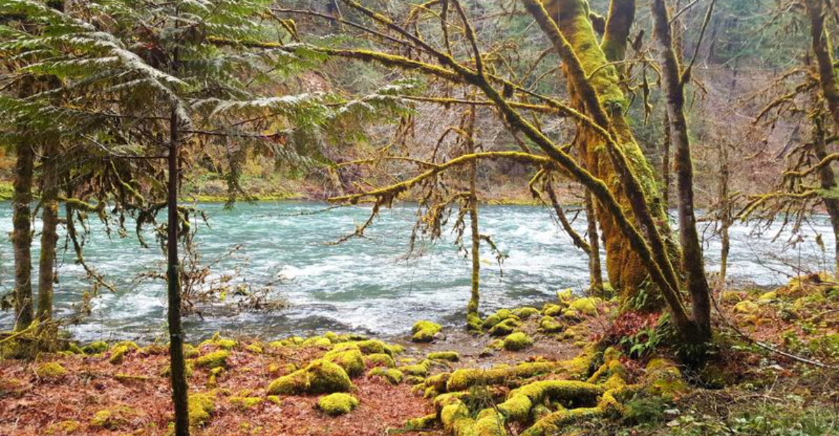
The River That Runs the Whole Show

The North Umpqua River is not a quiet background feature. It is the defining character of this entire trail system, and once you understand that, the hike makes a different kind of sense.
The river runs cold and fast year-round, fed by snowmelt from the Cascade Range, and its color shifts from deep jade to bright turquoise depending on light and season.
Sections of the trail run right along the riverbank, close enough that spray occasionally reaches the path during high water. The sound of moving water is constant in those segments, a rhythmic background that makes the miles pass faster than expected.
Anglers come here specifically for the wild summer steelhead and native rainbow trout that hold in the deeper pools.
The river corridor also creates a natural wind tunnel that keeps temperatures noticeably cooler than surrounding areas, which is a genuine relief during Oregon’s warmer months. Several informal access points allow hikers to scramble down to the water’s edge for a rest or a cold foot soak.
The river earned its wild and scenic designation, and spending time near it makes that designation feel entirely justified rather than bureaucratic.
Trail Conditions and What to Realistically Expect

Honesty about trail conditions is more useful than enthusiasm, and this trail demands both. The North Umpqua Trail is well-maintained in its more popular segments, but certain sections, particularly the remote stretches, can have significant blowdown after winter storms.
The Dread and Terror segment, named with appropriate flair, has been known to present dozens of fallen trees across the path during years when clearing crews have not yet reached it.
Before any trip, calling the North Umpqua Ranger District office or checking the Umpqua National Forest website for current conditions is genuinely worth the five minutes it takes. Trail reports from recent hikers on platforms like AllTrails can also flag specific issues like washed-out sections or overgrown brush.
The terrain itself ranges from smooth riverside paths to rocky climbs with moderate elevation gain. Trekking poles are helpful on the steeper sections, and waterproof boots are a practical choice for most of the year.
Ticks are active during wet seasons, so wearing long pants and using appropriate repellent on both yourself and any dogs is standard advice that experienced visitors follow without hesitation.
Lemolo Falls and the Dread and Terror Segment

Few trail names in the Pacific Northwest carry as much personality as Dread and Terror, and the segment lives up to its billing in the best possible way. This stretch of the North Umpqua Trail passes through a particularly wild and remote section of the canyon, where the forest closes in tightly and the river drops into dramatic gorges below.
Lemolo Falls is the reward at the end of this segment’s effort. The waterfall drops roughly 100 feet into a narrow basalt canyon, and the viewpoint delivers one of the most striking natural scenes in all of Douglas County.
The falls are not widely known outside of Oregon hiking circles, which means the crowd situation is refreshingly manageable compared to more publicized waterfalls in the state.
Reaching Lemolo Falls requires commitment. The trail is not a casual stroll, and the return trip covers the same terrain.
Sturdy footwear and a packed lunch make the experience considerably more enjoyable. The falls are most dramatic in spring when snowmelt swells the volume, but the canyon retains its atmosphere in every season, and autumn brings a warm palette of color to the surrounding maple and alder trees that frames the falls beautifully.
Hot Springs Along the Route

The North Umpqua corridor holds a surprise that catches many first-time visitors off guard: natural hot springs accessible from the trail system. Umpqua Hot Springs, located within Toketee-Rigdon Recreation Area, is the most well-known thermal feature in the region, and reaching it involves a short but steep hike down from a parking area near the Toketee Reservoir.
The hot springs are not a casual side trip. The path down to the pools is uneven and can be slippery, so appropriate footwear matters more than people expect.
The pools themselves are tiered into the hillside above the river, with temperatures varying by pool and by season. The setting, with forested slopes rising on all sides and the sound of the river below, is genuinely striking.
Visitor numbers at the hot springs have increased significantly over the past decade, so arriving early in the morning on weekdays offers the best chance of a quieter experience. Weekends during summer can be crowded enough to diminish the sense of seclusion that makes the spot special.
The Forest Service has implemented a permit system at peak times, so checking current requirements before visiting prevents an unwelcome surprise at the trailhead.
Wildlife and What the Forest Quietly Offers

The wildlife along this trail does not announce itself. You have to slow down and pay attention, which turns out to be one of the more valuable things a trail like this teaches.
Black-tailed deer are common throughout the corridor, often browsing the fern-covered slopes in early morning before retreating deeper into the forest.
Osprey work the river with remarkable efficiency, hovering briefly before dropping feet-first into the current. River otters appear occasionally in the calmer pools, and American dippers, small gray birds that walk underwater along stream bottoms, are a dependable sighting near the river’s edge.
Black bears are present in the Umpqua National Forest and are occasionally spotted, though they are far more interested in huckleberry patches than in hikers.
The bird diversity along this trail rewards anyone carrying binoculars. Varied thrushes, Steller’s jays, and pileated woodpeckers are all regular presences in the old-growth sections.
The pileated woodpecker in particular, North America’s largest woodpecker, leaves unmistakable rectangular excavations in dead snags that serve as proof of its work even when the bird itself stays hidden. The forest here functions as a complete ecosystem, and that completeness is palpable.
Mountain Biking the North Umpqua Trail

The North Umpqua Trail has developed a serious reputation in the mountain biking community, and that reputation is well-earned. Certain segments of the trail are open to bikes and offer some of the most technically engaging singletrack riding in southern Oregon, combining tight forest corridors, root-laced surfaces, and river views into a riding experience that keeps both hands on the handlebars and both eyes on the trail.
The river segments are particularly popular with cyclists because the trail rolls and winds with the terrain rather than cutting straight lines, which creates a rhythm that experienced riders find deeply satisfying. Beginner cyclists should be honest about their skill level before attempting the more rugged sections, as some stretches have significant exposure and technical challenges that catch underprepared riders off guard.
Mountain biking and hiking do share portions of the trail, so mutual awareness and trail etiquette matter. Bikers yield to hikers on uphill sections, and keeping speeds reasonable in blind corners is standard practice rather than optional courtesy.
The trail’s surface changes with the seasons, and riding after heavy rain creates conditions that are both more challenging and more damaging to the trail surface, so dry-weather visits are preferable for everyone involved.
Best Times to Visit and Seasonal Realities

Late spring through early fall covers the most reliable window for hiking the North Umpqua Trail, with June through September offering the longest days and the most stable conditions. Snow can linger at higher elevations into May, and the trail’s lower river segments can flood during peak runoff in late winter and early spring.
Summer brings warm days but the river corridor stays noticeably cooler than surrounding areas, making midday hiking more comfortable than you might expect for July in Oregon. The downside of summer is that ticks are active through the wet early season, and mosquitoes can be persistent near standing water in June.
Bug repellent and tick checks at the end of each day are habits worth developing quickly.
Autumn is genuinely spectacular here. Bigleaf maples turn gold and orange in October, and the reduced visitor numbers after Labor Day make the trail feel dramatically more spacious.
Winter hiking is possible in the lower segments but requires waterproof gear and a tolerance for mud. Spring brings wildflowers, high water in the river, and a freshness to the forest that rewards those willing to deal with unpredictable weather for a few hours at a time.
Camping and Extending Your Time on the Trail

A single day on the North Umpqua Trail is a good introduction, but spending several nights in the area transforms the experience entirely. The Umpqua National Forest offers multiple developed campgrounds along the Highway 138 corridor, including Susan Creek Campground and Horseshoe Bend Campground, both of which sit close to trailheads and provide direct river access.
Susan Creek has basic amenities including vault toilets and fire rings, and its position along the river makes evenings at camp genuinely pleasant. Horseshoe Bend is slightly larger and fills quickly on summer weekends, so reservations through Recreation.gov are strongly recommended for Friday and Saturday nights between June and September.
Backpacking within the national forest is permitted with a free self-issue wilderness permit at most trailheads, and dispersed camping away from water sources and trails is allowed in designated areas. Spending a week working through different trail segments, as experienced visitors often recommend, allows you to cover the variety the system offers, from riverside meadows to ridgeline views.
The reward for that kind of commitment is a level of familiarity with this landscape that a single day simply cannot provide, and the forest tends to reveal itself slowly to those who stay long enough to listen.


