The Clinton River Trail in Auburn Hills follows a former railroad corridor that many Metro Detroit drivers pass without realizing it is there. The paved path cuts through wooded areas, crosses major roads and highways, and connects nearby communities in a way that feels far removed from the traffic surrounding it.
What makes this stretch stand out is how thoughtfully designed it is for walkers, runners, and cyclists. Along the route, you will find bike repair stations, shaded rest areas, and easy access points that make the trail feel welcoming even for first-time visitors.
For locals who know about it, it has quietly become one of the area’s best places to slow down and spend a few hours outdoors.
Where the Trail Begins: Location and Access in Auburn Hills

The Auburn Hills section of the Clinton River Trail runs for approximately 2.1 miles in an east-west direction between Adams Road and Opdyke Road, right in the heart of Oakland County, Michigan.
The Opdyke trailhead is one of the most convenient entry points, with dedicated parking and a clear trail entrance that makes the start of your ride or walk completely stress-free.
A municipal parking lot at 25 Grey Road in Auburn Hills also serves trail users, giving you a solid backup option if the main lot is busy on a weekend morning.
The trail surface through Auburn Hills is fully paved, which makes it accessible for cyclists, inline skaters, joggers, and anyone pushing a stroller or using a wheelchair.
The location puts you close enough to everyday Auburn Hills life that you can pop in for a trail visit without making it a full-day production, which is honestly part of its charm.
A Railroad That Became a Recreation Route

Back in 1880, a railroad was built to connect Pontiac to Romeo, cutting through what would eventually become the suburban landscape of Oakland County.
Grand Trunk Western Railroad took ownership of the line and kept trains rolling on it for well over a century, which is a surprisingly long run for a regional rail corridor.
The railroad was finally abandoned in 1998, and the rails were pulled up in 1999, leaving behind a flat, straight right-of-way that was practically begging to become a trail.
After several years of planning and construction, the Clinton River Trail officially opened in the spring of 2004, giving Oakland County residents a new way to move through their communities without a car.
That history gives the trail a quiet sense of purpose, like it has always been meant to carry people forward, just in a different way than anyone originally planned when those first tracks were laid.
The Pedestrian Bridge Over I-75 That Changes Everything

One of the most genuinely impressive features of the Auburn Hills section is the pedestrian bridge that carries trail users safely over Interstate 75, one of the busiest highways in the state.
Without that bridge, the trail would essentially be cut in two, forcing users to navigate a dangerous highway crossing or simply turn around and head back the way they came.
The bridge makes the full east-west connection possible, letting you cross from one side of the city to the other with nothing but smooth pavement under your wheels and open sky above your head.
It is the kind of infrastructure investment that does not always get celebrated loudly, but anyone who has used the trail knows exactly how much it matters in practice.
Once you cross it and look down at the traffic rushing below, there is a quiet satisfaction in knowing you are moving through Auburn Hills completely under your own power, and that never really gets old.
What the Trail Feels Like on an Average Tuesday Morning

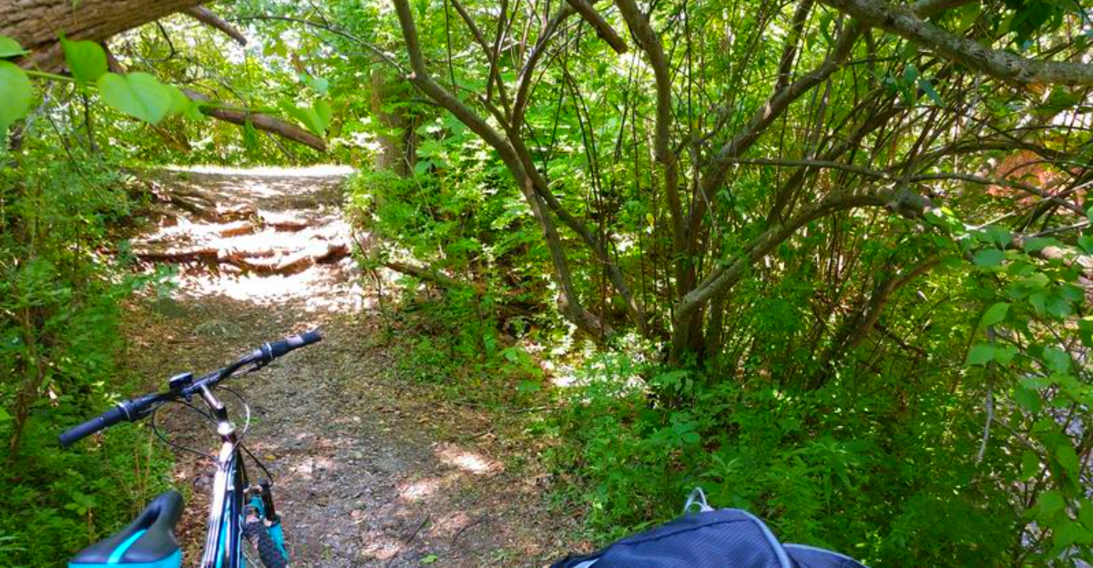
The Auburn Hills section of the trail runs through stretches of wooded corridor that block out a surprising amount of road noise, even though you are never far from the suburban grid surrounding you.
On a weekday morning, the trail is quiet in a way that feels almost deliberate, with just enough other users to feel safe and social, but not so crowded that you feel like you are navigating a sidewalk rush hour.
The paved surface stays in solid condition, and the tree cover on either side creates a natural tunnel effect that keeps things cooler in summer than you might expect for a Metro Detroit trail.
There is a rhythm to moving along a former rail line that flat, straight paths tend to produce, where your pace locks in and your mind starts to wander in the best possible way.
The trail does not try to dazzle you with dramatic scenery; instead, it offers something more reliable, a consistently pleasant experience that earns your return visits without needing to make any big promises.
The Unexpected Wildlife and Nature Moments Along the Trail

One of the most surprising things about the Auburn Hills section of the Clinton River Trail is how quickly the suburban surroundings seem to disappear once you are moving beneath the trees. Despite sitting in the middle of a heavily developed part of Oakland County, the trail attracts a steady presence of wildlife that makes the experience feel far more natural than most visitors expect.
Songbirds move through the wooded corridor in the early mornings, squirrels dart between the trees, and deer are occasionally spotted near the quieter stretches closer to dawn and dusk. During warmer months, butterflies and dragonflies drift across the trail edges while the tree canopy filters sunlight into shifting patches across the pavement.
The Clinton River itself is never far away, and that connection to water helps support the surprisingly calm ecosystem surrounding the path. On especially quiet mornings, the sounds of traffic fade enough that birdsong and rustling leaves take over completely.
For regular trail users, those small nature moments become part of the reason they return. The trail is not just a place to exercise or commute between communities.
It is one of those rare suburban spaces where you can genuinely slow down, notice your surroundings, and feel briefly disconnected from the constant pace of Metro Detroit life.
The Gazebo, the Benches, and the Art of the Trail Rest Stop

The Opdyke trailhead does not just offer a place to park and start moving; it gives you a reason to linger before and after your ride with a proper gazebo, picnic table, and benches arranged for actual human comfort.
That gazebo is shaded, which matters more than people give it credit for during a Michigan July when the sun is doing its absolute best work on exposed concrete and asphalt.
Hydration stations are also available at the trailhead, which removes one of the most common excuses for cutting a trail visit short before you have really gotten into your stride.
The combination of shade, seating, and water access makes the Opdyke end of the Auburn Hills section feel like a destination in itself, not just a launching pad for the miles ahead.
Families especially tend to appreciate these amenities, since not every member of the group will want to cover the full 2.1-mile stretch, and having a comfortable place to wait makes the whole outing work for everyone.
How Auburn Hills Fits Into the Bigger Trail Picture

The Auburn Hills segment is just one piece of a trail that stretches roughly 16 to 17 miles total, connecting Sylvan Lake, Pontiac, Auburn Hills, Rochester Hills, and Rochester in a single continuous corridor through Oakland County.
On the west end, the Clinton River Trail links up with the West Bloomfield Trail, and on the east end, it connects to the Macomb Orchard Trail, which means the network you can access from Auburn Hills is far larger than the 2.1 miles within city limits suggests.
The trail also serves as a critical segment of the Iron Belle Trail, Michigan’s epic route stretching from Belle Isle in Detroit all the way to Ironwood in the Upper Peninsula.
It is part of the Great Lake-to-Lake Trails Route 1 as well, a cross-state path running from South Haven on Lake Michigan to Port Huron on Lake Huron.
That regional connectivity transforms a casual Auburn Hills trail visit into a potential gateway for much longer adventures, depending on how ambitious you are feeling that particular morning.
Who Manages This Trail and Keeps It Running

Each of the five cities the trail passes through owns and maintains its own portion of the Clinton River Trail, which means Auburn Hills is directly responsible for keeping its 2.1-mile segment in the condition trail users experience every time they visit.
Behind that city-level management sits the Friends of the Clinton River Trail, a volunteer-driven nonprofit that works across all five municipalities to coordinate standards, encourage consistent use, and push for ongoing improvements along the full corridor.
That kind of community-based stewardship is part of why the trail has stayed in solid shape over the years, with additions like the fix-it stations and hydration points reflecting organized advocacy rather than accidental luck.
Volunteers show up for cleanup days, trail counts, and community events that keep the space feeling cared for and welcoming rather than neglected or overlooked.
If you end up falling in love with the trail the way a lot of regular users do, the Friends organization is worth looking into as a way to give something back to the corridor that gave you all those good miles.
Best Times to Visit and What to Expect Each Season

The trail in Auburn Hills is genuinely usable across multiple seasons, and the experience shifts enough between them that returning visitors often develop a favorite time of year that feels like a personal discovery.
Late spring and early fall tend to draw the most consistent praise, with mild temperatures and tree cover that is either freshly green or burning orange and red depending on which direction the calendar is moving.
Summer mornings before 9 a.m. are ideal for avoiding heat and finding the trail at its most peaceful, with long light and cool air making even a quick 2-mile loop feel like a proper outdoor experience.
Winter does not shut the trail down entirely, and cross-country skiing is listed as an activity option for the broader Clinton River Trail corridor when conditions cooperate.
Spring 2026 brought some trail closures in sections further east near Rochester due to washout repairs, so checking the Friends of the Clinton River Trail website before a visit is always a smart move, especially after heavy rain seasons.
What to Bring and How to Make the Most of Your Visit

A visit to the Auburn Hills section of the Clinton River Trail does not require a lot of gear, but a few basics make the experience noticeably better from start to finish.
Water is an obvious necessity, and while the hydration stations at the Opdyke trailhead take care of refills, bringing your own bottle means you are never dependent on whether the station is functioning that particular day.
A helmet is non-negotiable for cyclists, and comfortable shoes with decent grip make a real difference for anyone planning to walk or jog the full 2.1-mile stretch.
The fix-it stations handle basic mechanical issues, but carrying a spare tube and a small pump is a habit worth developing if you plan to use the trail regularly or extend your ride beyond Auburn Hills into neighboring communities.
Parking is free at both the Opdyke trailhead and the municipal lot on Grey Road, so the only real cost of a visit here is the energy you bring with you, which the trail tends to give back in full.


