There is a waterfall in northern Alabama that most people have never heard of, and that is exactly what makes it so special. It drops into a deep, cavernous sinkhole on the side of a mountain, and the whole scene feels like something out of a nature documentary.
The trail to reach it winds uphill through a preserve that quietly protects one of the most dramatic natural formations in the state. By the time you hear the rush of water echoing off the rocks below, you will understand why hikers keep coming back to this hidden corner of Alabama.
Where Exactly This Place Is and How to Get There

Getting to Lost Sink Falls requires a little more effort than typing an address into your phone and following it blindly. The official trailhead is at Keel Mountain Preserve, located at 1455 McMullen Rd, Gurley, AL 35748, tucked into the foothills of northeast Alabama.
Here is the thing that trips up almost every first-time visitor: Google Maps directions are notoriously unreliable for this spot. Following them without thinking can land you at a private residence with no trail in sight.
The correct move is to search for “Keel Mountain Preserve” rather than the falls themselves. Once you find McMullen Road, drive slowly and watch for the Keel Mountain Preserve sign near the gravel parking lot.
The lot is small, so arriving early on weekends is a smart call.
Gurley sits in Madison County, not far from Huntsville, making this a very doable day trip from that city. Unlike the flashier destinations you might find in Oklahoma or other states, this one rewards the patient visitor who pays attention to the details before leaving home.
The Story Behind the Sinkhole and the Falls

Not every waterfall ends in a pool you can splash around in, and Lost Sink Falls is proof of that in the most fascinating way possible. The water here does not collect at the bottom in a calm basin.
Instead, it plunges directly into a deep sinkhole, a natural void in the earth that swallows the falls whole.
Sinkholes form when underground rock, usually limestone, erodes over thousands of years until the ground above it collapses inward. The result at Keel Mountain is a dark, cavernous opening that visitors describe as both beautiful and slightly unsettling.
Hikers who have tossed rocks into the chasm report hearing them echo far below for several seconds, suggesting the depth is considerable. A ten-foot log thrown into the opening reportedly disappeared entirely.
The preserve itself is managed by The Nature Conservancy, an organization that protects the land from development and keeps the natural processes running as they should. This is not a manicured park with guardrails and gift shops.
The raw, unfiltered quality of the place is exactly what makes it memorable and worth every muddy step on the way up.
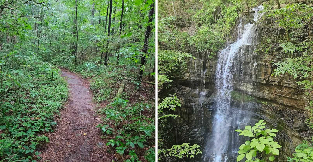
What the Trail Feels Like from Start to Finish

The hike to Lost Sink Falls covers just under three miles round trip, and that distance is deceptively straightforward on paper. The trail starts out relatively flat, almost lulling you into a comfortable pace, before gradually shifting into a steady uphill climb that works your legs more than you might expect.
Rocky terrain, exposed tree roots, and patches of loose shale all appear along the way, so proper footwear is not optional here. Trail runners or sturdy hiking boots are the right call, especially after any recent rainfall when the clay sections turn slick fast.
About ten small trail signs appear along the route, but they are not always placed at the moments when you need them most. Several hikers recommend downloading the CartoTracks map of Keel Mountain Preserve or using AllTrails before heading out, since the trail can seem to disappear in a few spots.
The reward for staying on course is hearing the falls before you see them, a low rushing sound that grows louder as the trees thin out near the sinkhole. That audio cue, roughly 200 to 300 meters from the destination, is one of the most satisfying moments of the entire experience.
How Long the Hike Takes and What Affects Your Pace

Most solo hikers or pairs in decent shape reach the falls in about 25 to 50 minutes, depending on how often they stop and how aggressively the trail is fighting back that day. The return trip, being mostly downhill, tends to take noticeably less time.
Families with younger children should plan for a longer outing. Several visitors have hiked this trail with kids as young as five and six years old, and while it is doable, the steeper sections genuinely wear out small legs.
An eight-year-old and a ten-year-old reportedly loved the adventure, while a seven-year-old found it quite tough going.
People with asthma or mobility concerns have completed this trail successfully by pacing themselves and using trekking poles for the inclines. The mix of flat stretches and uphill sections means there are natural rest points built into the route.
Round trips with extended time at the falls, including breaks and exploration, have ranged from about 90 minutes to over three hours depending on the group. Packing snacks, plenty of water, and a light layer for the cool air near the sinkhole makes the whole experience considerably more comfortable from start to finish.
The Sinkhole Up Close and the Temperature Drop That Surprises Everyone

Reaching the edge of the sinkhole for the first time is a genuinely striking moment. The waterfall drops into an opening in the earth that feels almost canyon-like in its scale, with rough rock walls descending into cool darkness below.
One of the most consistently mentioned details from visitors is the sudden drop in temperature near the sinkhole. The cold air rising from the depths creates a natural air-conditioning effect, and on a warm Alabama afternoon, that chill hits you like stepping into a shaded stone cellar.
It is a physical reminder that something unusual is happening underground.
The view from the top of the sinkhole is already impressive, but the more adventurous option is to carefully descend partway down the steep, slippery clay slope using a rope that has been tied off for that purpose. The descent is not required to enjoy the falls, but those who make it down describe the perspective from below as completely different and worth the extra caution.
There is no swimming area at the bottom, so leave the swimsuit at home. The experience here is entirely about witnessing something geological and rare, and that turns out to be more than enough to make the trip feel worthwhile.
Best Time of Year to Visit for Maximum Impact

Timing your visit to Lost Sink Falls can make a real difference in what you experience when you finally arrive at the sinkhole. The waterfall flows more impressively after significant rainfall, and several visitors specifically recommend planning your trip within a day or two of a good storm.
Spring tends to deliver the most reliable combination of water flow and comfortable hiking temperatures, with the surrounding forest a rich green that frames the sinkhole dramatically. Late May visits have drawn particularly enthusiastic responses from hikers who caught the trail at its most lush.
Fall is another strong choice, especially for anyone drawn to changing leaf colors on the hillside. One visitor mentioned wanting to return in autumn specifically to see how the scenery transforms when the foliage shifts.
Late fall and winter are the least recommended seasons, primarily because the trail markings become harder to follow when leaves cover the ground, and the path can feel more disorienting without the visual cues that green vegetation provides.
The preserve is open daily from 7 AM to 5:30 PM, so an early morning start on a weekday is the sweet spot for avoiding crowds and catching the trail in quiet, low-traffic conditions that make the whole hike feel more personal.
Wildlife, Nature, and What You Might Encounter Along the Way

The trail through Keel Mountain Preserve passes through a forest that is genuinely alive in the most literal sense. One hiking group reported butterflies landing directly on them throughout their ascent, a detail that sounds almost too charming to be true but has been mentioned more than once.
The preserve protects a natural ecosystem, which means the wildlife here is not curated or managed for visitor comfort. Rattlesnakes have been spotted along the trail, and at least one hiker turned back after encountering one close to the path.
Staying alert, watching where you step, and keeping to the marked trail reduces risk considerably.
The forest itself shifts in character as you climb, with the understory changing and the rock formations becoming more prominent near the top. Mossy boulders, exposed roots, and thick tree cover create a textured environment that rewards slow, observant hiking.
The preserve is also dog-friendly, which is a detail that brings plenty of four-legged hikers to the trail on weekends. Keeping dogs leashed in a habitat with native wildlife is both responsible and required by the preserve’s guidelines.
Nature here behaves on its own schedule, and part of the appeal of this trail is accepting that the experience will be slightly different every single time you visit.
Parking, Trailhead Logistics, and What to Know Before You Go

The parking situation at Lost Sink Falls is one of the most talked-about logistical quirks of the entire visit, and for good reason. The lot is small, gravel-surfaced, and easy to miss if you are driving at normal road speed on McMullen Road.
A sign for Keel Mountain Preserve marks the entrance, but it does not announce itself loudly from the road. Driving slowly and keeping your eyes left or right depending on your direction of approach is the practical advice that saves most first-timers from overshooting it twice.
There are no bathroom facilities at the trailhead, which is worth knowing before you load up on coffee for the drive out. No picnic tables, no visitor center, and no cell service in parts of the preserve either, so downloading your maps before leaving home is a non-negotiable step.
Weekday mornings offer the most relaxed parking experience, with one visitor reporting they passed only a single other hiker during an entire weekday outing. Weekends can fill the small lot quickly, especially in spring.
The preserve’s website through The Nature Conservancy provides additional details about access and trail conditions, and checking it before a visit is a small effort that prevents a lot of unnecessary surprises on arrival.
Gear and Preparation That Makes the Difference

A hike to Lost Sink Falls is not the kind of outing where sneakers and a casual attitude carry you through comfortably. The terrain demands footwear with grip, and the clay sections of the trail after rain are slippery enough to send unprepared hikers sliding in ways that are more embarrassing than entertaining.
Trekking poles are not required, but hikers with knee concerns or respiratory conditions have found them genuinely useful on the steeper inclines. The trail’s mix of flat and steep sections means your legs are doing two very different jobs in quick succession, and poles help maintain balance through those transitions.
Water is essential, and more of it than you think you need for a sub-three-mile hike. The climb generates real exertion, and the cool air near the sinkhole can trick you into thinking you have not worked as hard as you actually have.
Downloading the CartoTracks map of Keel Mountain Preserve or the AllTrails version of this trail before leaving cell range is genuinely useful and free. The trail markers are better than they used to be, but a few sections still require a digital assist to stay confidently on course without adding unnecessary distance to your day.
The Atmosphere at the Falls and Why It Stays With You

There is something genuinely hard to describe about standing at the edge of Lost Sink Falls for the first time. The combination of the falling water, the cold air rising from below, and the sheer vertical drop into darkness creates an atmosphere that is both peaceful and quietly intense.
The acoustic experience alone is worth noting. Sound bounces off the rock walls of the sinkhole in a way that makes the falls seem louder and more powerful than they might appear from above, and that echo adds a dramatic quality to the whole setting.
Visitors consistently describe the place as feeling remote and undiscovered, even though it is less than an hour from Huntsville. That sense of earned solitude, arriving at something genuinely wild after a real physical effort, is a feeling that polished tourist attractions rarely deliver.
The canyon-like quality of the sinkhole, with its rough walls and the cool darkness below, gives the location a character that feels more like something you would find in a remote part of Oklahoma or the Appalachian backcountry than in a preserve accessible from a paved county road.
Most hikers linger longer than they planned, and that says more about the place than any description could manage on its own.
How This Trail Compares to Other Alabama Hikes

Northeast Alabama does not always get the hiking spotlight that states like Colorado or even neighboring Tennessee tend to attract, but the trails in this region have a quiet confidence that rewards the curious traveler.
Lost Sink Falls stands out among local hikes not because of its length or difficulty, but because of its destination. Most trails in the area lead to overlooks or creek crossings.
This one leads to a geological feature that genuinely has no equivalent nearby, which gives it a reputation that spreads mostly through word of mouth.
The moderate rating is accurate for most adults in reasonable shape, though the steeper sections near the top push it toward the challenging end for beginners or young children. Compared to heavily trafficked trails in other states, including popular routes in Oklahoma, the low foot traffic here on weekdays feels like a real luxury.
The round trip distance of just under three miles keeps it accessible without feeling trivial. You earn the view without needing a multi-day backpacking setup to get there.
For anyone building a hiking itinerary through Alabama, this trail belongs near the top of the list, not because it is the longest or the most dramatic, but because it offers something genuinely unusual for the region.
Final Thoughts on Making the Trip Worth Every Step

Lost Sink Falls is the kind of place that earns its reputation slowly, one shared photo and one word-of-mouth recommendation at a time. It does not advertise itself with billboards or tour packages, and the slightly tricky navigation to get there feels intentional in the best possible way.
The hike asks something real of you, a genuine physical effort on uneven terrain, and then pays you back with a natural feature that is unlike anything most people have seen in person. That transaction feels honest in a way that over-developed tourist destinations rarely do.
Bringing snacks, arriving early, downloading your trail map ahead of time, and wearing the right shoes covers about ninety percent of what you need to do to have a great visit. The other ten percent is simply showing up ready to be surprised.
Alabama tends to fly under the radar when people plan outdoor adventures, often losing attention to states like Oklahoma or the Carolinas, but spots like this one make a compelling case for paying closer attention. The next time someone tells you there is nothing worth hiking in Alabama, you will have a very specific and satisfying answer ready for them.


