There is a stretch of southwestern Oklahoma where the land opens wide, the sky presses low, and history feels close enough to touch. Out here, near the small community of Indiahoma, a granite monument stands quietly beside the road, marking the edge of what was once the greatest Native American territory on the Great Plains.
The Comancheria Historical Marker honors Quanah Parker, the last chief of the free Comanche people, and the sweeping homeland his ancestors called their own. I made the drive out here on a clear afternoon, and I can tell you honestly that few roadside stops have ever hit me this hard.
Keep reading, because this one is worth every mile.
The Landmark and Where to Find It

Right off the highway near Indiahoma, Oklahoma 73552, the Quanah Parker and Comancheria Historical Marker sits in a modest roadside pull-off that punches well above its weight in meaning. The GPS coordinates place it at roughly 34.63 degrees north, and the address is simply Indiahoma, OK 73552, with a contact number of +1 580-581-3500 available for more information.
The marker is open 24 hours a day, seven days a week, and admission is completely free. There are no restrooms, no garbage cans, and no running water on site, so plan accordingly before you arrive.
The setting itself does a lot of the storytelling. To the east, the Wichita Mountains rise in soft blue ridges, and the surrounding plains stretch in every direction with a kind of quiet that feels earned rather than empty.
A quick visit can last anywhere from ten minutes to an hour, depending on how long you stand and let the history settle in. The landmark is listed and documented at hmdb.org, and it earns its 4.5-star rating with nothing more than stone, text, and landscape.
The Story Behind the Stone

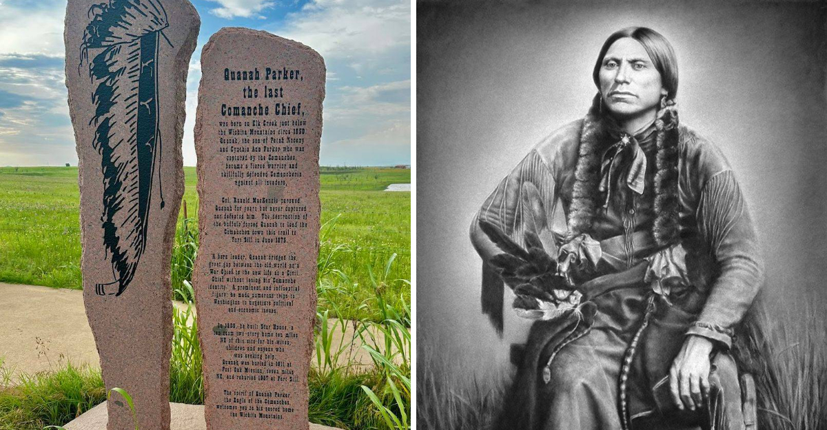
Not every roadside marker carries the weight of an entire civilization, but this one does. The granite monument tells the story of the Comanche Nation and its vast territory known as Comancheria, a region that once covered much of the southern Great Plains, including large portions of present-day Texas, New Mexico, Colorado, Kansas, and Oklahoma.
At the center of that story is Quanah Parker, a man whose life bridged two very different worlds. Born around 1845 to Comanche chief Peta Nocona and Cynthia Ann Parker, a white woman captured and raised by the Comanche, Quanah grew up entirely within Comanche culture and became one of the most formidable leaders the tribe ever produced.
The marker does not shy away from the complexity of that history. It acknowledges the freedom the Comanche once held across these plains and the painful transition that followed.
Reading the engraved text carefully, you start to understand why so many visitors describe the experience as unexpectedly moving. The words are measured and respectful, and they let the scale of what happened here speak for itself without dramatizing it.
Who Was Quanah Parker

Quanah Parker was not just a chief. He was a symbol of resilience during one of the most turbulent periods in Native American history.
As the son of Cynthia Ann Parker and Peta Nocona, he carried a dual heritage that made him a unique figure both within the Comanche Nation and in his later dealings with the United States government.
He rose to prominence as a war leader of the Quahadi band, one of the most independent and resistant groups within the broader Comanche Nation. He led raids and resisted the encroachment of settlers and the U.S.
Army throughout the early 1870s, earning a fierce reputation on the southern plains.
When the Red River War of 1874 forced the Comanche onto the reservation at Fort Sill in present-day Oklahoma, Quanah adapted with remarkable skill. Rather than retreating into bitterness, he became a successful rancher, a diplomat, and an advocate for his people.
He passed away in 1911, leaving behind a legacy so layered and significant that it still draws visitors to this quiet corner of Oklahoma more than a century later. Few lives contain that many chapters.
What Comancheria Actually Meant

The word Comancheria refers to the vast territory that the Comanche people dominated from roughly the early 1700s through the 1870s. At its peak, this homeland covered an estimated 240,000 square miles across the southern plains, and the Comanche controlled it with a military effectiveness that stunned Spanish, Mexican, and American forces alike.
The Comanche were horse culture specialists. After acquiring horses from Spanish settlements in the late 1600s, they became the most skilled equestrian warriors on the continent, and that skill turned the open plains into a domain they could defend and exploit with remarkable efficiency.
Comancheria was not just a geographic territory. It was a way of life built around bison hunting, seasonal movement, and a social structure that valued individual bravery and communal loyalty in equal measure.
Standing at the marker and looking out across the Oklahoma grasslands, you get a faint but real sense of what that landscape must have felt like when it belonged entirely to the people who shaped their entire culture around it. The horizon feels different when you carry that knowledge with you.
The Granite Monument Up Close

The physical monument itself is worth examining carefully, because the craftsmanship reflects genuine respect for the subject. The granite is dark and polished, with engraved text that covers both the front and back faces of the stone.
On the back, there is a map that shows the extent of Comancheria, and that map alone is worth the stop.
Seeing the sheer size of the territory laid out in engraved lines gives you a visual reference that no paragraph of text can quite replicate. The Comanche homeland was enormous, and the map makes that undeniable in a way that is both educational and quietly sobering.
The monument sits on a clean concrete base and is well-maintained despite its remote location. The surrounding pull-off area is simple and uncluttered, which actually works in the marker’s favor.
There is nothing to distract you from the stone and the sky.
Visitors consistently describe the marker as aesthetically appealing and tastefully done, and that assessment holds up on inspection. Whoever designed this monument understood that restraint can carry more power than ornamentation, and the result is a piece that earns its place in the landscape.
The Road to Fort Sill and What It Represents

One of the most affecting aspects of this site is its proximity to Fort Sill, the U.S. Army post in Lawton, Oklahoma, where the Comanche were ultimately settled after the Red River War of 1874.
The marker essentially sits along the path that Quanah Parker and the remaining free Comanche traveled when they made their final journey to the reservation.
That journey was not a defeat in the conventional military sense. The Comanche were not beaten in a single decisive battle.
Instead, the U.S. Army, under General Ranald Mackenzie, systematically destroyed their food supplies, their horses, and their ability to survive the winter on the plains, leaving them with no viable path forward.
Quanah led his band into Fort Sill in June of 1875, and that moment marked the end of free Comanche life on the southern plains. The marker acknowledges this transition without sensationalizing it, which is exactly the right approach.
Standing here and looking toward the east, where Fort Sill still operates as an active military installation, the distance between past and present collapses in a way that is hard to explain but easy to feel. The road between then and now runs right through this spot.
The Surrounding Landscape and Wichita Mountains

The landscape around the marker does as much storytelling as the stone itself. The Wichita Mountains sit to the east, their rounded granite peaks rising unexpectedly from the flat plains in a way that feels almost theatrical.
These mountains were sacred to the Comanche and to many other Plains tribes, and they still carry a presence that is hard to dismiss even on a casual visit.
The Wichita Mountains Wildlife Refuge, which surrounds much of the range, protects one of the last remnants of the mixed-grass prairie ecosystem that once covered this entire region. Bison still roam there, which adds a layer of historical resonance that visitors consistently appreciate.
The grasslands between the marker and the mountains are wide and largely undeveloped, which means the view from the pull-off is genuinely close to what it would have looked like during Quanah Parker’s time. That continuity is rare and valuable in a landscape that has otherwise changed enormously.
On a clear day, the combination of open plains, distant mountains, and enormous sky creates a visual context for the Comanche story that no museum exhibit can quite match. The land itself becomes part of the exhibit, and it does not disappoint.
Quanah Parker’s Later Life and Legacy

After settling at Fort Sill, Quanah Parker did something that few people in his position managed to do. He built a new kind of power within the constraints of reservation life, and he used that power to advocate for the Comanche people with skill and persistence.
He became the principal chief of the Comanche Nation, a title that carried political weight in negotiations with the federal government. He learned English, adopted elements of American business culture, and became a successful rancher on leased reservation lands, running large cattle operations with the help of Texas ranchers who respected his authority and his practicality.
His Star House in Cache, Oklahoma, became a gathering place for both Comanche people and prominent American visitors, including President Theodore Roosevelt, who hunted with Quanah on the Oklahoma plains. That connection speaks to the remarkable social range Quanah operated across during his later years.
He never stopped identifying as Comanche, and he worked consistently to preserve Comanche culture, language, and land rights within the new system. His legacy is complicated and layered, which is exactly what makes it worth understanding.
Simple stories rarely belong to extraordinary people.


