There is a trail in Oregon that quietly earns its reputation every single season, drawing hikers who come for the waterfalls and leave speechless because of the summit. The path climbs more than 4,000 feet through ancient forests, past cascading water, and up to a viewpoint where five volcanic peaks line up on the horizon like a postcard nobody could have staged.
I have hiked trails from the coast of Maine to the high deserts of the Southwest, but few places have stopped me mid-step the way this one did. By the time you reach Sherrard Point at the top, you will understand exactly why Pacific Northwest hikers keep coming back here year after year.
Where the Trail Begins: Address, Location, and First Impressions

The trailhead for Larch Mountain Trail sits near Troutdale, Oregon 97060, in the Columbia River Gorge National Scenic Area, and the drive alone hints at what is waiting ahead. The road winds through dense forest canopy, and by the time you reach the parking area, the air already smells different from the city.
The official contact number is (541) 308-1700, and the trail is open 24 hours a day, seven days a week, which means early risers and golden-hour chasers both have a fair shot at a peaceful experience. A Northwest Forest Pass or a five-dollar day-use fee is required to park, so keep that in mind before you leave home.
The trailhead has vault toilets that are surprisingly well maintained for a backcountry facility. Restrooms, a paved parking lot, and clear signage make the starting point easy to navigate even for first-time visitors.
Getting there early on weekends is the single best piece of advice anyone can give you about this place.
The Waterfall Parade Along Multnomah Creek

Four waterfalls greet you along the lower section of Larch Mountain Trail, and each one feels like a reward for the steps you just climbed. The trail follows Multnomah Creek for much of its lower stretch, and the sound of rushing water becomes a steady companion for the first four to five miles.
Upper Multnomah Falls is the anchor of this waterfall sequence, and the trail climbs past it with a series of switchbacks that give you changing views of the cascade as you rise. After that first big climb, the grade eases somewhat, and three additional waterfalls appear at intervals that feel perfectly spaced for catching your breath.
Several of the waterfall pools are deep enough for wading, and on a warm summer afternoon the cool water is genuinely refreshing after a long uphill push. Bridges cross the creek at key points, adding a bit of charm to an already scenic stretch of trail.
The waterfall section alone is worth the trip, even if you never make it to the summit.
Old-Growth Forest That Makes You Feel Small in the Best Way

Ancient Douglas firs and western red cedars line the upper sections of the trail, and some of these trees have been standing for centuries. The trunks are so wide that two people stretching their arms cannot reach around them, and the bark has developed deep, furrowed ridges that look almost sculptural up close.
The forest floor stays cool and shaded even on hot summer days, which makes the upper trail a genuinely comfortable place to hike when lower elevations feel sweltering. Moss covers nearly every surface, from fallen logs to exposed rocks, giving the whole corridor a lush, almost otherworldly quality.
One reviewer described a section near the old logging corridor as so dense and dark that it felt like dusk even when the sun was still high. That description is accurate.
The old-growth sections near the summit carry a kind of quiet that is hard to find anywhere near a major city, and the contrast with the logged areas nearby makes the preserved forest feel even more precious. Every step through this stretch feels like walking through living history.
The Big Climb: Elevation, Terrain, and What Your Legs Are In For

The full Larch Mountain Trail covers 7.2 miles one way from Multnomah Falls, with a total elevation gain of roughly 4,000 feet. That number sounds manageable on paper, but the trail earns its moderate-to-difficult rating honestly, especially in the final two miles where the grade sharpens and the steps carved into the hillside grow taller.
The terrain shifts noticeably as you gain elevation. The lower section follows a smooth, well-worn path beside the creek, while the upper sections introduce rocky footing, exposed roots, and in early season, patches of snow that can linger well into May or even June.
Proper footwear is non-negotiable here. Hiking boots with ankle support handle the rocky stretches far better than trail runners, and trekking poles make a genuine difference on the descent when tired legs meet steep terrain.
The trail is not a casual stroll, but it rewards effort with scenery that scales proportionally with every foot of elevation you gain. The burn in your legs at the top feels completely worth it.
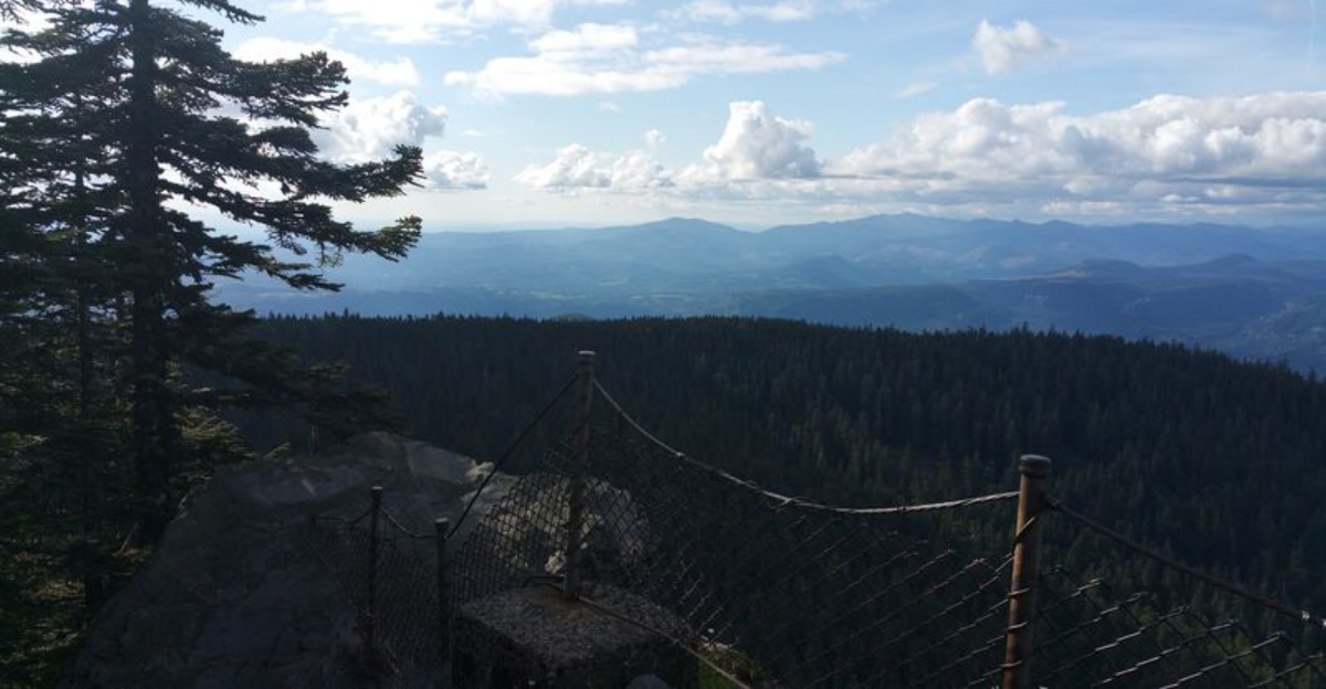
Sherrard Point: The Summit View That Justifies Every Step

Sherrard Point sits at the top of Larch Mountain at an elevation of 4,056 feet, and the view from its rocky outcrop is the kind that makes hikers stop mid-sentence and just stare. On a clear day, five Cascade volcanic peaks are visible simultaneously: Mount Hood, Mount Adams, Mount Rainier, Mount St. Helens, and Mount Jefferson.
The final approach to Sherrard Point involves a short, steep set of railroad-tie-sized steps that catch some visitors off guard after miles of hiking. People with mobility limitations may find this last section challenging, and alternative viewpoints like Crown Point offer easier access to the gorge views if needed.
The summit area also includes a picnic space with tables and small grills, which makes it a surprisingly pleasant spot for a packed lunch with an extraordinary backdrop. The Columbia River is visible far below, threading through the gorge like a silver ribbon.
Arriving at Sherrard Point after a full climb from Multnomah Falls produces a satisfaction that is hard to replicate on shorter, easier trails anywhere in the Pacific Northwest.
Wildlife, Mushrooms, and the Quiet Surprises Along the Way

Larch Mountain Trail has a reputation among foragers and nature watchers as a place where the forest reveals itself slowly and generously. The loop trail through the upper forest is particularly rich with mushrooms in the fall, and hikers who take their time often spot species that fill entire field guides.
Owls are a real presence here, especially near the forest edges where open areas meet old-growth stands. One visitor described watching a large owl swoop silently from the tree line and vanish back into the canopy, a moment that felt genuinely wild and unscripted.
Bears also move through the area, so making noise on the trail and carrying bear awareness is sensible rather than paranoid.
Wild strawberry plants grow in rocky sections of the old logging roads, though they rarely produce berries. The diversity of what the trail offers beyond the waterfalls and summit views is part of what makes repeat visits feel worthwhile.
Every season brings a different set of surprises, from spring wildflowers to fall fungi to winter frost patterns on the creek rocks that look like natural art installations.
Trail Connections: Wahkeena Falls, Cougar Rock, and Beyond

One of the underrated advantages of Larch Mountain Trail is how well it connects to the broader trail network of the Columbia River Gorge. From the summit area, hikers can link to trails heading toward Wahkeena Falls, Cougar Rock, and a series of ridgeline routes that extend the adventure considerably.
The connection to Wahkeena Falls creates a popular loop option that lets hikers experience two distinct creek drainages in a single outing. The Wahkeena side of the loop tends to be slightly less trafficked than the Multnomah approach, which appeals to anyone who prefers a quieter stretch of trail.
Cougar Rock adds a different character to the experience, offering exposed rocky sections with open views that contrast nicely with the dense forest corridors elsewhere on the mountain. Planning a multi-trail day here requires a good map and some advance research, but the payoff in variety and mileage is substantial.
The trail network around Larch Mountain essentially lets you design your own adventure, from a gentle two-mile stroll around the summit picnic area to a full-day, double-digit-mile wilderness loop.
Best Times to Visit and What Each Season Offers

Spring brings the most dramatic waterfall displays, as snowmelt from the upper mountain pushes Multnomah Creek to its highest volume. The trail can be muddy in March and April, but the payoff in water volume and wildflower color makes the soggy boots worth tolerating.
Summer is peak season, and the summit road sometimes stays closed into late May due to snow. Checking road conditions before driving up saves a frustrating turnaround.
The summit area gets noticeably cooler than the gorge floor, so packing an extra layer even in July is a smart habit rather than an overcautious one.
Fall is arguably the most rewarding season for the trail itself, with fungi everywhere, golden light filtering through the canopy, and far fewer visitors than the summer rush. Winter visits are possible but require microspikes or traction devices for the icy upper sections.
Hikers who have explored trails across the country, from the Appalachians to the high deserts, often say the Pacific Northwest fall season at elevation is in a category of its own for sheer atmospheric beauty.
Practical Tips: Gear, Permits, and Trail Etiquette

A Northwest Forest Pass covers the parking fee at Larch Mountain, and America the Beautiful passes are also accepted. At five dollars for a day pass, the cost is reasonable, but forgetting it means a ticket, so tuck it in the glove box the night before your visit.
Water is available from the creek in the lower sections of the trail, but it requires filtering before drinking. Carrying at least two liters per person from the trailhead is the safer approach, especially on warm days when the upper mountain offers no reliable water sources.
Dogs are welcome on the trail but must be kept on a leash, both for wildlife protection and for the comfort of other hikers.
The trail sees enough traffic that Leave No Trace principles matter here in a real way. Staying on the marked path prevents erosion and keeps hikers from getting turned around near the old fire pits and picnic tables scattered through the forest interior.
Cell service is unreliable above the lower trailhead, so downloading an offline map before you go is a practical step that takes about two minutes and could save a much longer headache on the mountain.
Why This Trail Deserves a Spot on Every Pacific Northwest Bucket List

Few trails in the Pacific Northwest pack this much variety into a single route. Waterfalls, old-growth forest, volcanic summit views, wildlife encounters, and trail connections to neighboring drainages all appear within the same hike, which is not something most trails can claim regardless of their reputation.
The trail also holds a quiet cultural significance for the region. Long before modern hikers discovered it, the area around Larch Mountain was used by Indigenous peoples and later by early loggers whose remnant machinery and old-growth stumps still appear along the historic logging corridors.
That layered history gives the trail a depth that purely scenic routes sometimes lack.
Hikers who have tackled trails in many states, including those far from the Pacific Northwest like the rugged backcountry of Oklahoma, often describe Larch Mountain as a place that recalibrates their expectations for what a day hike can deliver. The combination of accessibility from Portland, the dramatic elevation change, and the summit payoff makes it genuinely hard to argue against.
Oregon has many great trails, but this one earns its 4.8-star reputation the honest way, one waterfall and one vertical foot at a time.


