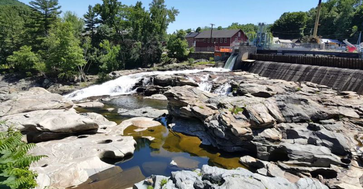
Tucked into a small western Massachusetts village, a stretch of ancient bedrock along the Deerfield River holds one of the most fascinating geological formations in all of New England. More than 50 circular rock pools, some as wide as 39 feet, were carved into the riverbed by the grinding force of glacial meltwater thousands of years ago.
This place is unlike anything most people have ever seen in person. The potholes sit right in the heart of a charming downtown, making them surprisingly easy to visit, and the story behind their formation is the kind of thing that makes you stop and rethink just how powerful natural forces can be over long stretches of time.
This article covers everything worth knowing before your visit.
How Ancient Glaciers Did the Carving Work

The story of how these pools formed goes back roughly 14,000 years, to the end of the last Ice Age. As massive glaciers retreated across New England, they left behind torrents of meltwater that rushed over the exposed bedrock of the Deerfield River.
Small stones and boulders got caught in the fast-moving whirlpools created by that rushing water. Over thousands of years, those stones spun in place like natural drills, grinding circular holes into the solid rock beneath them.
The result is a collection of more than 50 perfectly round or oval pools, ranging from a few inches across to nearly 39 feet in diameter.
The process is called pothole formation, and while it happens in other places around the world, the concentration and size of the potholes at Shelburne Falls make this site particularly rare. Geologists consider this one of the finest examples of glacial pothole formation in the entire northeastern United States.
What the Potholes Actually Look Like Up Close

From the observation deck, the potholes spread out across the riverbed in a way that is genuinely hard to prepare for. The bedrock is dark and worn smooth in places, and the pools themselves vary wildly in size, from small bowl-shaped depressions to massive circular craters that could hold a small car.
The color of the surrounding boulders in the river adds to the visual contrast, with shades of gray, rust, and greenish tones visible depending on the light and water level. During periods of low water flow, most of the potholes are visible and dry enough to show their full depth and shape clearly.
When water levels rise after heavy rain or during spring runoff, the potholes fill up and the river moves fast and dramatically through the site. Both conditions offer a completely different kind of viewing experience, which is one reason regular visitors tend to return at different times of year to see how the scene changes.
The Best Time of Year to Visit

Timing a visit to the potholes makes a real difference in what you get to see. Late summer is widely considered the best window for viewing the potholes themselves, because water levels in the Deerfield River tend to drop enough to expose most or all of the formations.
Spring visits bring a completely different kind of power to the site. Snowmelt and seasonal rainfall push water levels up significantly, and the river can move through the area with remarkable force and speed.
The potholes may be mostly hidden under water during peak spring flow, but the visual drama of the rushing river is worth the trip on its own.
Autumn is another strong option, particularly during the peak foliage period in October. The surrounding trees shift into deep reds, oranges, and golds, and the late afternoon light makes the whole scene especially photogenic.
Each season brings something different, so there is no truly wrong time to stop by Shelburne Falls for a look.
The Observation Deck and Viewing Area Setup

The viewing setup at the potholes is simple but well thought out. A wooden boardwalk and observation deck sit directly above the formation, giving a clear overhead view of the potholes without requiring any climbing or scrambling over rocks.
The deck is described as well-built and safe, and it has been decorated with flowering plants that add a bit of color to the structure. Several benches are positioned along the viewing area, making it easy to sit and take in the scene at a relaxed pace rather than rushing through.
A monument sign near the parking area provides historical and geological context about the potholes, which helps visitors understand what they are looking at before they reach the deck. The whole setup is compact and manageable, meaning a typical stop here takes somewhere between 10 and 30 minutes depending on how long you want to linger.
Families with kids tend to find the layout particularly easy to navigate without stress.
Parking and Getting There Without the Headache

One of the practical advantages of visiting the Shelburne Falls Potholes is how easy parking tends to be. Parallel parking is available very close to the lookout point, and the surrounding downtown area of Shelburne Falls also has additional street parking on most days without much competition for spots.
The site sits just off Bridge Street, which is the main road through the village center. There are no complicated directions or hidden trailheads to navigate, and the monument sign near the viewing area makes the spot easy to identify even for first-time visitors who have never been to the area before.
For those driving through western Massachusetts on Route 2, the potholes are only a short detour off the main road and well worth the few extra minutes it takes to reach them. Public restroom access near the immediate site is limited, so planning ahead before arrival is a practical step worth taking before heading out.
The Connection to the Famous Bridge of Flowers

The potholes are not the only reason people make their way to Shelburne Falls. Just steps away from the geological viewing area sits the Bridge of Flowers, a former trolley bridge that has been transformed into a pedestrian walkway covered in hundreds of flowering plants maintained by a local horticultural society.
The two attractions sit close enough together that visiting both on the same trip requires almost no extra effort. Many people who come specifically for the potholes end up spending extra time on the flower bridge, and vice versa.
The combination of geological history and community-maintained natural beauty makes Shelburne Falls a genuinely layered destination.
The Bridge of Flowers is typically in full bloom from spring through autumn, with the peak display happening in late spring and early summer. Together, the potholes and the flower bridge represent two very different kinds of natural wonder existing side by side in one small Massachusetts village, which is a combination that is hard to find anywhere else in the region.
Photography Tips for Getting the Best Shots

The potholes are a genuinely photogenic subject, but the quality of the shots you get depends a lot on timing and conditions. Golden hour in autumn is widely regarded as the best window for photography at this site, when low-angle light catches the texture of the bedrock and the surrounding foliage adds warm tones to the frame.
Shooting from the observation deck gives a broad overhead perspective that captures the scale and arrangement of the pools effectively. For more detail-oriented shots, focusing on individual potholes with a tighter zoom helps communicate just how deep and precisely formed these natural structures are.
Water level plays a big role in composition. Low water in late summer exposes the full shapes of the pools, while higher spring water creates more dynamic movement in the frame.
Early morning visits tend to offer softer light and fewer people on the deck, which gives more flexibility for positioning and framing without other visitors in the way.
The Geological Significance That Sets This Spot Apart

Not every state has a glacial pothole site worth writing home about, but Massachusetts got lucky with this one. The Shelburne Falls Potholes are considered one of the finest examples of this geological phenomenon in the northeastern United States, and the sheer number and variety of the formations in one location is what makes the site stand out from similar spots elsewhere.
The largest pothole at the site measures nearly 39 feet in diameter, which puts it among the biggest known examples of this type of formation in the country. The fact that the site sits in an active river rather than a dry or semi-dry location means the natural processes that created it are still technically ongoing, even if at a much slower pace than during the glacial period.
Geology enthusiasts and educators regularly bring groups to the site for this reason. The combination of accessibility, visual clarity, and scientific significance makes it a natural classroom that requires no special equipment or expertise to appreciate.
How Access to the Site Has Changed Over the Years

Long-time visitors to the Shelburne Falls Potholes will tell you that the experience has changed noticeably over the decades. In earlier years, people could walk directly on the pothole rocks, get close to the water’s edge, and explore the formation in a much more hands-on way.
Safety concerns eventually led to the installation of fencing and restricted access around the formation itself. Today, the potholes are a view-only experience from the observation deck, and the riverbank downstream is surrounded by private property with posted signs limiting access.
Some longtime fans of the site find the current setup less engaging than what they remember, while newer visitors tend to appreciate the well-organized viewing area for what it offers. The trade-off between safety and immersive access is a familiar challenge at many natural landmarks, and Shelburne Falls has landed on the cautious side of that equation.
The view from the deck remains clear and rewarding, even if the up-close access of earlier eras is no longer available.
Where Exactly to Find This Geological Marvel

Right in the center of a quiet New England village, one of the most remarkable geological formations in Massachusetts sits waiting to be discovered. The Shelburne Falls Glacial Potholes are located at J726+W7, Shelburne Falls, MA 01370, just off Bridge Street along the Deerfield River.
The viewing area is easy to reach and sits within walking distance of the town’s small downtown shops and the famous Bridge of Flowers. There is parallel parking very close to the lookout point, so arriving by car is straightforward even for first-time visitors.
A monument sign marks the spot, and a well-maintained observation deck gives a clear view of the potholes below. Shelburne Falls itself is located in Franklin County in western Massachusetts, roughly along Route 2, making it a natural stop for anyone exploring that part of the state.
The whole setup makes this one of the most accessible natural wonders in the region.


