There is a spot in Oregon where you can stand in one place and see five massive volcanoes at the same time. No driving around, no squinting at distant ridgelines from a highway pullout.
Just one circular viewing platform perched on top of Larch Mountain, with the entire Cascade Range laid out in front of you like a geography lesson you actually want to attend. I had heard people talk about this place for years, and when I finally made the drive up that winding mountain road, I understood why nobody ever stops talking about it.
Sherrard Point is the kind of viewpoint that makes you feel like the world got bigger overnight, and every single detail of the experience, from the hike to the plaques to the volcanic skyline, is worth knowing before you go.
Where Exactly You Are Going

The address that gets you closest to this viewpoint is along Larch Mountain Road, Corbett, Oregon 97014, sitting at coordinates 45.5326996 latitude and -122.0878303 longitude in the Columbia River Gorge region east of Portland.
Larch Mountain itself rises to about 4,056 feet, and Sherrard Point is the rocky summit at its crown. The drive from Portland takes roughly an hour, winding through forest roads that tighten and curve as you gain elevation.
The parking lot near the trailhead is large and free on most visits, though some seasons require a Northwest Forest Pass or a small day-use fee, so it is worth checking current conditions before you leave home.
Cell service disappears well before you reach the top, so downloading a map or screenshotting directions ahead of time is genuinely important here, not just a nice idea. Once you pull into that big gravel lot and step out of the car, the cool mountain air hits you right away, and the tree canopy above makes the whole place feel quieter than the city you left behind.
The Short But Steep Trail to the Top

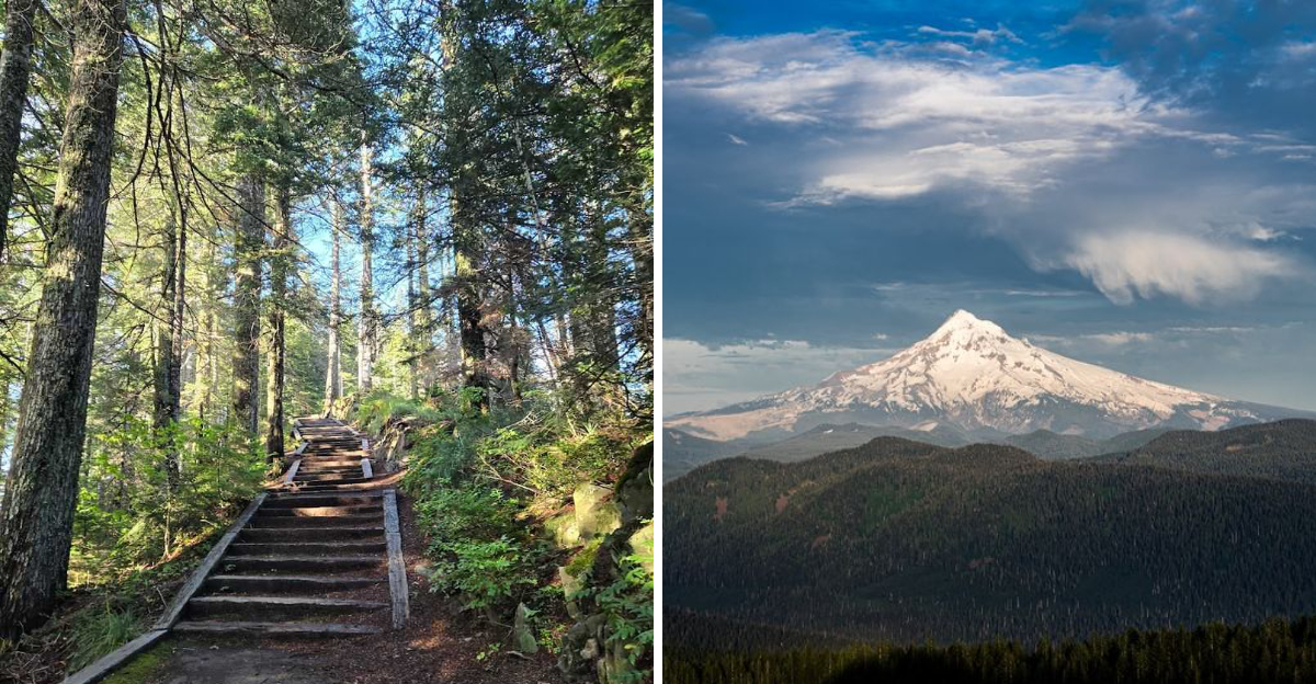
The trail from the parking lot to Sherrard Point is less than half a mile one way, which sounds easy until you hit the stairs. The path starts out mostly flat and paved with asphalt, cutting through a dense canopy of fir and hemlock that keeps things shady and cool.
Then comes the staircase. More than a hundred railroad tie steps climb the steepest section just before the viewing deck, and they do not let up until you reach the top.
For most healthy adults the climb takes under fifteen minutes, but the grade is real enough that you will feel it in your legs.
The trail is accessible enough for older kids and reasonably fit adults, though anyone with knee or mobility concerns should know about those stairs before committing to the hike. Dogs are welcome on leash, which makes this a solid outing for four-legged hiking companions too.
One quirky bonus along the way is a wrecked SUV visible down in the trees off the side of the trail, which has become its own minor attraction among curious visitors who spot it and immediately start wondering about the backstory.
Five Volcanoes in One Panoramic View

The main reason people make the drive up here is the view, and it delivers in a way that photographs struggle to capture. From the circular stone viewing platform at the summit, you can see five major Cascade stratovolcanoes spread across the horizon in nearly every direction.
Mount Hood rises to the east, close enough to feel almost personal. Mount Jefferson appears to the south, though it tends to hide behind haze and is best spotted on the clearest days of the year.
To the north, across the Columbia River and into Washington state, you can pick out Mount Rainier, Mount St. Helens, and Mount Adams lined up like a trio of frosted peaks waiting to be noticed.
Informational plaques are mounted around the outer wall of the viewing deck, each one identifying a specific volcano and sharing details about its height and location. These plaques make the experience genuinely educational without feeling like a museum exhibit.
Very few places in the Pacific Northwest offer this kind of multi-volcano lineup from a single fixed point, which is exactly what gives Sherrard Point its reputation as one of the more special viewpoints in the entire region.
The Best Conditions for the Clearest Views

Timing matters a lot when you plan a visit here. The Cascade volcanoes are only fully visible on days when the sky is genuinely clear, and Oregon weather does not always cooperate.
Summer months from late June through September tend to offer the best visibility, with dry air and long days working in your favor.
Spring and fall can still produce stunning views, but cloud cover is more likely to roll in and block the distant peaks, especially Mount Jefferson to the south. Winter visits are possible and reportedly spectacular when the sky clears, but the road to Larch Mountain closes during heavy snow and ice, so checking road conditions with the Forest Service before heading out is essential.
Mornings generally offer crisper air and less atmospheric haze than afternoons, making an early start a smart strategy. Sunset visits have their own appeal, with the fading light turning the volcanic summits shades of orange and pink that feel almost theatrical.
Whatever season you choose, a clear forecast is the single most important factor in whether you leave feeling amazed or mildly disappointed, so keep an eye on the weather in the days leading up to your trip.
Two Ways to Reach the Summit

Getting to Sherrard Point is not a one-size-fits-all situation, because there are actually two distinct routes to choose from depending on how much of a workout you are after.
The first option is to drive Larch Mountain Road all the way to the summit parking lot, then walk the short half-mile trail to the viewpoint. This is the popular choice for families, casual hikers, and anyone who wants to spend their energy enjoying the view rather than earning it.
The second option is a full hiking experience that starts at Multnomah Falls, one of Oregon’s most visited natural landmarks. The Larch Mountain Trail from Multnomah Falls covers roughly fourteen miles round trip with significant elevation gain, winding through old-growth forest and past smaller viewpoints along the way.
The longer trail is a genuine all-day undertaking that rewards experienced hikers with solitude, forest scenery, and the satisfaction of arriving at the summit on foot. In winter, the upper sections of this trail can be icy enough to require microspikes, and snow above 3,000 feet is common from late November through early spring, so gear choices matter considerably on that route.
Stargazing After Dark

Most people come here for the daytime volcano views, but the nighttime version of this place is something else entirely. Larch Mountain sits far enough from Portland’s city lights that the sky above Sherrard Point goes genuinely dark after sunset, creating near-perfect conditions for stargazing.
The Milky Way is visible on clear moonless nights, and the lack of artificial light pollution means even faint stars show up in ways they simply cannot closer to the city. The large parking lot stays accessible after dark, making this a destination that works equally well for evening visits as for morning ones.
Bring a warm jacket regardless of the season, because temperatures at 4,000 feet drop noticeably after sunset even in summer. A red-light headlamp is useful for reading star maps without ruining your night vision, and a blanket or camp chair makes a long stargazing session much more comfortable.
The combination of volcanic mountain silhouettes on the horizon and a fully lit sky overhead creates a visual experience that feels completely different from the daytime panorama, almost like visiting two separate destinations in one trip without moving more than a few feet from the viewing platform.
The History Behind the Name

The point carries the name of James W. Sherrard, a former president of the Mazamas, the Portland-based mountaineering club that has been active in the Cascade Range since 1894.
The Mazamas played a significant role in developing access to and awareness of Larch Mountain in the early twentieth century.
The organization was instrumental in promoting outdoor recreation in the Pacific Northwest at a time when the region was still being mapped and explored by non-Indigenous settlers. Their legacy includes trail work, summit registers, and advocacy for preserving access to wild places across Oregon and Washington.
The stone viewing platform at Sherrard Point was constructed to provide a safe and lasting structure at the summit, and the informational plaques were added to help visitors understand what they were looking at across the volcanic horizon. These plaques identify each peak by name and elevation, turning a casual visit into something genuinely informative.
Knowing the history behind the name adds a small but satisfying layer to the experience, connecting the modern-day visitor to a long tradition of people who climbed this same summit and stood on this same rocky edge, looking out at the same five volcanoes stretching across the sky.
Facilities and Practical Visitor Information

Practical details can make or break a day trip, and Sherrard Point has a reasonable set of amenities for a mountain summit. The parking lot is large and well-maintained, with room for plenty of vehicles even on busy summer weekends.
Restrooms are available at the trailhead, which is a genuine convenience at this elevation and distance from town. Picnic tables near the parking area make it easy to bring lunch and turn the trip into a relaxed half-day outing rather than a rushed viewpoint stop.
Cell service is essentially nonexistent once you get into the upper sections of Larch Mountain Road, so any navigation, maps, or information you need should be downloaded or screenshotted before you leave a coverage area. This is one of those places where a little pre-trip preparation pays off in a big way.
Parking fees and pass requirements can vary by season and land management updates, so checking with the Mount Hood National Forest or the Oregon Department of Forestry before your visit ensures you arrive with the right payment ready and no surprises waiting in the lot. Arriving early on summer weekends helps avoid crowding at both the parking area and the viewing platform itself.
What the Viewing Deck Feels Like Up Close

The viewing platform at the top is a circular stone structure with a low outer wall, and the informational plaques mounted around its perimeter are genuinely well done. Each plaque points toward a specific volcano and includes the peak’s name, elevation, and distance from where you are standing.
The deck is not enormous, so on a busy day you share the space with other visitors, but the circular layout means everyone can rotate around and find their angle without too much crowding. The rocky summit terrain around the platform has a raw, windswept quality that contrasts nicely with the smooth paved trail you just walked up.
On a clear day the views hit you all at once the moment you step onto the platform, and the instinct to spin slowly in a full circle is almost involuntary. Mount Hood dominates the eastern view and feels remarkably close given its actual distance.
The benches that once occupied the platform appear to have been removed at some point, so plan to stand or bring a small portable seat if you want to linger. The plaques make it easy to identify every peak even if you are not a seasoned mountaineer, which is one of the small design details that makes this spot so visitor-friendly.
The Drive Up Larch Mountain Road

The road to the summit is an experience in itself. Larch Mountain Road winds upward through progressively denser forest, with the trees closing in on both sides as the pavement narrows and the turns get tighter.
The drive takes about thirty to forty minutes from the base, depending on your starting point, and the scenery along the way shifts from open pastoral landscape near the Columbia River Gorge to old-growth forest as you gain elevation. Cyclists also use this road regularly, so keeping an eye out and giving them plenty of room is part of the deal.
The road closes seasonally when snow and ice make it impassable, typically from sometime in November through late spring, though the exact dates vary year to year based on conditions. Checking road status before making the drive is especially important from October through May.
On a clear summer morning the drive itself sets the mood beautifully, with filtered light coming through the canopy and the temperature dropping noticeably as you climb. By the time you reach the parking lot, you already feel like you have traveled somewhere properly remote, even though Portland is less than thirty miles away as the crow flies.
Sunrise and Sunset Visits Worth Planning For

Few natural light shows compare to watching the sun rise or set from a high-elevation platform with a clear line of sight to five major peaks. The eastern orientation toward Mount Hood makes Sherrard Point a particularly strong sunrise spot, with the first light of morning catching the snow on Hood’s upper slopes before it touches anything else on the horizon.
Sunset works beautifully from the gorge-facing side of the platform, where the Columbia River valley below catches warm light and the sky behind the western ridgeline turns deep shades of orange and gold. One visitor experience that stands out in the collective memory of this place is watching the strawberry moon rise from behind Mount Hood, a sight that understandably made a lasting impression.
Getting to the parking lot before sunrise requires driving the mountain road in darkness, which is manageable but calls for a fully charged phone, downloaded maps, and a reliable flashlight. The reward for that early effort is often having the viewing platform entirely to yourself during the most photogenic minutes of the day.
Sunset visits tend to attract slightly more company, but the platform is large enough to share, and the shared experience of watching the light fade over five volcanoes has its own quiet, communal energy.
Why This Place Stays With You Long After You Leave

Some viewpoints are impressive in the moment but fade quickly from memory once you are back on the highway. Sherrard Point is not one of those places.
The combination of physical effort, even on the short route, and the scale of what you see at the top creates a memory that tends to stick.
The fact that you can see five distinct stratovolcanoes from a single fixed point is geologically remarkable, and standing there with that knowledge makes the view feel earned rather than accidental. The plaques around the platform reinforce that sense of place, grounding the visual spectacle in real names, real distances, and real geological history.
People return here with out-of-town guests, come back in different seasons to compare the views, and make it a regular stop on Pacific Northwest road trips. The accessibility of the short route means almost anyone can experience the summit, while the longer trail from Multnomah Falls offers a completely different relationship with the mountain for those who want it.
Whatever brings you here the first time, the view from that circular stone platform has a way of making the world feel both larger and more comprehensible at the same time, which is a rare thing to find at the end of a half-mile walk.


