There is a spot in central Oregon where the ground looks like it was rearranged by something enormous, dark, and unstoppable. A perfectly shaped volcano rises 500 feet from a sea of hardened lava, and the whole scene feels like a page ripped straight out of Earth’s geological diary.
The area sits inside Newberry Volcano National Volcanic Monument, one of the most underrated outdoor destinations in the Pacific Northwest. Once you see the views from the top and learn how recently this volcano was active in geological terms, you will wonder why it took you this long to visit.
Where Exactly You Will Find This Volcanic Wonder

The address is NF-100, Bend, OR 97702, and the drive from downtown Bend takes roughly 20 minutes south along Highway 97. Lava Butte Cinder Cone sits within the Newberry National Volcanic Monument, managed by the Deschutes National Forest.
The monument covers nearly 55,000 acres of volcanic landscape, and Lava Butte is the first major landmark you encounter when entering from the north. A well-maintained visitor center greets you at the base, and the staff there are genuinely knowledgeable about the geology, history, and surrounding trails.
The phone number for the area is +1 541-593-2421, and you can also find more details at the official Deschutes National Forest website. The America the Beautiful national parks pass is accepted here, which is a nice bonus if you already carry one.
Parking near the visitor center is straightforward, and the whole setup makes first-time visitors feel welcome right from the start.
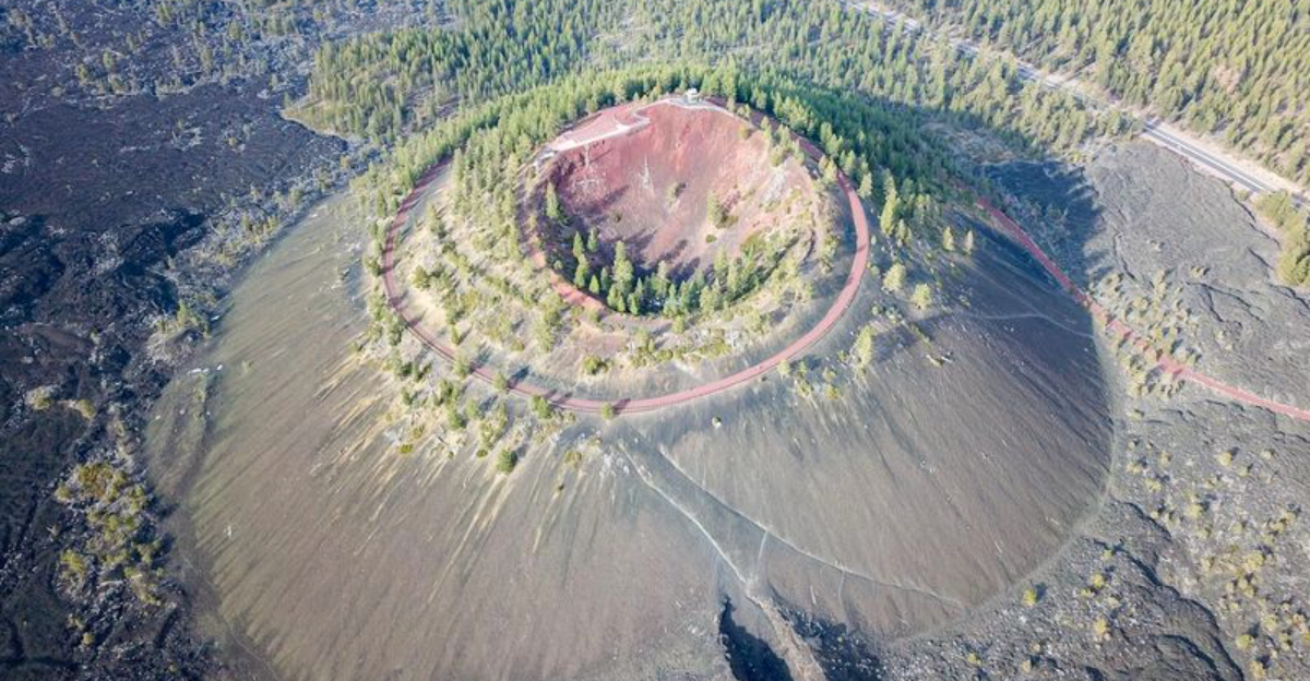
The Geological Story Behind a 7,000-Year-Old Eruption

About 7,000 years ago, a vent opened in the earth right here in central Oregon and began spewing lava, cinders, and volcanic gases into the sky. The eruption built up this nearly perfect cone shape over time, layer by layer, as hot material piled up around the vent.
The lava that flowed outward from the base spread over roughly nine square miles, covering everything in its path with a thick black blanket of basalt. That ancient flow is still visible today, and walking through it gives you a real sense of how powerful and far-reaching volcanic activity can be.
Geologists classify Lava Butte as a cinder cone, which means it formed quickly in a relatively short eruption compared to shield volcanoes or stratovolcanoes. The cone itself stands about 500 feet tall from its base, which is impressive considering it was built from loose volcanic debris.
The visitor center has excellent exhibits that walk you through the entire eruption sequence in a clear and engaging way.
Taking the Shuttle to the Summit

Getting to the top of Lava Butte does not require a grueling hike, and that is partly what makes this spot so accessible. A shuttle runs from the visitor center up the winding access road to the summit, and the ride costs a few dollars per person.
The shuttle departs roughly every 20 minutes during the operating season, so the wait is never too long. It is worth noting that the shuttle does not give change, so bringing exact cash makes the whole process smoother.
The ride itself is short but scenic, offering glimpses of the surrounding lava field as you climb.
During the off-season, vehicles are not permitted on the access road, but a pedestrian gate stays unlocked so hikers can walk the roughly one-mile road to the top. The grade is about 8 percent, which is manageable for most adults in reasonable shape but can be tiring for very young children.
Either way, reaching the summit feels genuinely rewarding, and the view waiting at the top makes every step worthwhile.
The Quarter-Mile Rim Trail Around the Crater

Once you reach the top of Lava Butte, a quarter-mile trail loops around the entire rim of the crater, and it is one of the most satisfying short walks you can take in Oregon. The path is compact but packs in 360-degree views that stretch across the entire central Oregon landscape.
The trail surface is covered in loose pumice gravel, which gives it a slightly crunchy, otherworldly feel underfoot. A few sections are a bit steep, so wearing sturdy shoes is a smart choice before you head up.
The trail takes about 20 minutes to complete at a relaxed pace, which makes it perfect for families or anyone who does not want a full-day hike.
The dark interior of the crater below the trail is striking, and the contrast between the black volcanic rock and the blue sky above can make for some genuinely stunning photos. Rangers stationed at the top are happy to share details about the geology and answer questions, turning the walk into a mini history lesson with an extraordinary backdrop.
What You See From the Fire Lookout at the Top

At the very top of Lava Butte, a historic fire lookout station sits right on the rim, and stepping inside it adds a whole new layer to the visit. The lookout contains panoramic maps mounted on the walls that identify every peak visible from the summit, which turns the view from impressive to genuinely educational.
On a clear day, you can spot the Three Sisters, Broken Top, Mount Bachelor, and even Mount Hood far to the north. That range of visibility covers hundreds of miles of Oregon’s volcanic landscape, all from one compact little building perched on a cinder cone.
Hazy days reduce the view, but the ranger on duty will usually tell you what you are missing and what to expect on a clearer visit.
The first dusting of autumn snow creates a beautiful contrast against the dark volcanic rock, making late September an unexpectedly photogenic time to visit. For the best lighting on the western peaks, arriving early in the morning puts the sun at your back and makes the Cascades pop in any photo you take from the lookout.
The Lava Flow Trails at the Base

Before or after heading to the summit, the trails at the base of Lava Butte offer a completely different perspective on the volcanic landscape. Paved paths wind through the hardened lava flow, and informational plaques along the route explain how the lava moved, cooled, and eventually became the rugged terrain you are standing on.
The contrast between the jet-black basalt and the patches of green vegetation that have slowly reclaimed parts of the flow is visually striking. Trees and shrubs have found ways to root themselves in the cracks of the lava over thousands of years, and the plaques point out these details in a way that is easy to understand.
At the western end of the trail, a viewing area looks out toward Mount Bachelor, the Three Sisters, and Broken Top, framed by the open sky and the edge of the lava field. The walk is relatively flat and suitable for most fitness levels, making it a great option for visitors who want to explore without committing to the summit.
Early morning light hits this section beautifully and rewards those who arrive before the crowds.
The Visitor Center and What It Has to Offer

The visitor center at the base of Lava Butte punches well above its weight in terms of what it offers. The exhibits inside cover the full story of Newberry Volcano, from its earliest eruptions to the most recent lava flows, and the displays are clear enough for kids to follow but detailed enough to satisfy adults with a serious interest in geology.
Staff members at the center are well-informed about not just Lava Butte but the entire monument, including the lava river cave, the obsidian flow, and the twin lakes at the caldera. Picking up a trail map or asking for recommendations can easily turn a quick stop into a full day of exploration.
Shuttle tickets for the summit are purchased here, and the gift shop carries books, maps, and souvenirs.
The center opens at 10 a.m. on most days during the operating season, so arriving just before opening means you can grab your pass and head up before the crowds build. The building itself is clean, well-maintained, and genuinely worth a full 20 to 30 minutes of your time before you even set foot on the volcano.
The Best Time of Year to Make the Trip

Timing a visit to Lava Butte can make a real difference in what you experience. Summer offers the most reliable weather and the full range of services, including the shuttle, the visitor center, and ranger programs, but it also brings the largest crowds, especially on weekends.
Late September is a genuinely underrated window for a visit. The crowds thin out, the air cools down, and if an early frost has dusted the cone with snow, the contrast between white and black volcanic rock creates a scene that feels almost unreal.
The visitor center and shuttle typically run through October depending on conditions, so checking ahead is a good habit.
Spring visits are possible but the access road may still be gated for vehicles, which means hiking up on foot. Winter closes most services, though the pedestrian gate often stays unlocked for those willing to make the uphill walk in cold conditions.
No matter what season you choose, a clear day is always the priority since the views from the top are the main event, and clouds or heavy haze can significantly reduce what you see.
Practical Tips for a Smooth Visit

A few small details can make the difference between a smooth visit and a frustrating one at Lava Butte. The shuttle does not carry change, so bringing exact cash for the ride is something worth remembering before you leave the visitor center.
The fee is just a few dollars per person, so it is easy to prepare in advance.
The America the Beautiful national parks pass is accepted at the entrance, which covers the day-use fee for the monument. If you visit national parks and monuments regularly, this pass pays for itself quickly and is well worth carrying.
Parking near the visitor center is the main lot, and the summit has limited spaces, so the shuttle system helps manage traffic at the top effectively.
Visits to the summit are recommended to stay under 30 minutes during busy periods to allow other visitors access to the limited space. Wearing layers is smart since the summit can be noticeably cooler and windier than the base, even on warm days.
Bringing water, especially if you plan to hike the base trails as well as the rim, keeps the whole outing comfortable from start to finish.
Why This Spot Deserves a Place on Your Oregon Itinerary

Central Oregon has no shortage of natural wonders, but Lava Butte holds a special place among them because it combines geological drama with genuine accessibility. You do not need to be an experienced hiker or a geology enthusiast to appreciate what this place has to offer, though both types of visitors tend to leave deeply impressed.
The combination of the interpretive trails, the knowledgeable rangers, the fire lookout, and the sweeping summit views gives Lava Butte a depth that rewards visitors who take their time. A quick stop off Highway 97 can easily stretch into a half-day adventure once you start exploring the lava flow trails and chatting with the staff at the visitor center.
Newberry National Volcanic Monument as a whole is not as widely known outside Oregon as it deserves to be, and Lava Butte is its most immediately striking feature. The 4.9-star rating from more than 100 visitors is not a coincidence.
Standing at the rim of a 7,000-year-old volcano, looking out across a landscape that stretches all the way to Mount Hood, is the kind of experience that stays with you long after the drive home.


