There is a place on the rocky tip of Cape Ann in Massachusetts where history and nature collide in a way that is hard to find anywhere else. A flooded granite quarry sits just steps away from the Atlantic Ocean, and a World War II observation tower rises above it all like a quiet sentinel.
The park is compact, the trails are easy, and the whole experience takes about an hour, yet people keep coming back. This is the kind of place that surprises you, whether you live nearby and never knew it existed, or you drove up from Boston just to see what the fuss was about.
Once you learn what is actually packed into this small coastal park in Rockport, Massachusetts, you will understand why it has earned such a devoted following among locals and travelers alike.
The Babson Farm Quarry That Started It All

The centerpiece of the park is the Babson Farm Quarry, a former granite quarry that stopped operations in 1929 and has since filled with rainwater to a depth of about 18 meters. The water takes on different colors depending on the time of day and season, ranging from a deep blue-green to a more muted gray tone in overcast conditions.
Granite from this quarry was used in construction projects across New England and beyond during the late 1800s and early 1900s. The industry was a major economic driver for Rockport and the surrounding Cape Ann region for decades before it wound down.
A trail loops around the quarry’s edge, giving clear views down into the water from several angles. There are no guardrails along the quarry rim, so careful footing is important.
Swimming in the quarry is not allowed. Early morning visits tend to offer the most striking water color before the light shifts overhead.
The World War II Observation Tower

One of the most unexpected features of the park is a concrete observation tower built during World War II. The tower was constructed as part of the coastal defense network that monitored the Atlantic for enemy vessels during the war years, and it still stands today as a preserved piece of military history.
The structure is made of thick concrete and has a utilitarian, no-frills design that reflects its wartime purpose. From the top, the views extend across the ocean and along the coastline in multiple directions, the same vantage point that military observers once used to scan the horizon.
The tower adds a layer of historical weight to what might otherwise feel like a purely natural setting. Combining that military history with a flooded industrial quarry and a wild Atlantic coastline makes this park genuinely unlike most other state parks in Massachusetts.
It is a compact place that carries a surprisingly large amount of history within its boundaries.
440 Million Years of Geology Underfoot

The granite at Halibut Point is not just a scenic backdrop. It is approximately 440 million years old, making it some of the oldest exposed rock in the region.
The geological history of Cape Ann is written directly into the stone that lines the coastline and surrounds the quarry.
Car-sized and truck-sized granite boulders are scattered along the ocean shoreline, tumbled into place over vast stretches of time. The sheer scale of the rocks along the water’s edge gives the park a dramatic, almost prehistoric quality that photographs struggle to fully capture.
The rocky shoreline is not a beach in any traditional sense. There is no sand, no gentle slope into the water, and no safe swimming area along the coast.
What it offers instead is a raw and unfiltered look at the Massachusetts coastline in its most natural state. Geologically speaking, every step through this park is a walk through deep time.
The Trails That Connect Everything

The trail system at Halibut Point is modest in length but covers a lot of ground in terms of what it shows you. The main loop is about 1.6 miles, and doing all available loops together can add up to roughly 2.5 to 3 miles total.
The terrain is mostly flat with a few sections that involve some up-and-down movement near the shoreline.
Trails are well-blazed with clear markers and signage throughout, so getting lost on the main paths is unlikely. The paths range from flat gravel and dirt roads to slightly more rugged rocky sections closer to the ocean.
Most of the trail system is accessible to people with strollers, though some loose gravel near the waterfront adds a bit of challenge.
Dogs are welcome on leashes, which is strictly enforced because the park borders a wildlife reserve on one side. The trail from Halibut Point to Cathedral Rocks is particularly recommended for the variety of coastal views it delivers along the way.
Ocean Views That Reach Three States

On a clear day, the views from the highest points of the park stretch far beyond the immediate coastline. From the boulder summit area, it is possible to see across Massachusetts, into New Hampshire, and on the clearest days, all the way to Maine.
That kind of multi-state panorama from a single vantage point is a rare thing to find in a park this small.
The Atlantic stretches out to the east with nothing between the shoreline and open ocean. The contrast between the ancient dark granite in the foreground and the wide expanse of water beyond it creates a visual that has made this park a popular destination for photography.
Sunset visits are particularly rewarding here. The light hits the granite and the water in ways that shift by the minute, and the park’s open western exposure means the sky puts on a full show.
Arriving at least an hour before sunset gives enough time to explore the trails and still catch the best light.
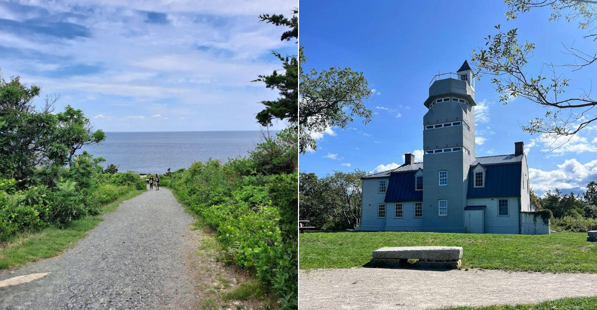
The Visitor Center With a Lighthouse Shape

The visitor center at Halibut Point is built in the shape of a lighthouse, which fits the coastal setting perfectly and makes it easy to spot from across the park. Inside, there are restrooms, interpretive displays about the park’s history, and information about the geology and quarrying operations that shaped the landscape.
Picnic tables are set up outside the visitor center, surrounded by more wooded and grassy areas rather than the open shoreline. The tables offer a shaded and relatively sheltered spot for a break, though they do not sit directly on the water or have ocean views.
The visitor center hours vary by season, and it is not always open, particularly in the late afternoon or off-season months. Portable restrooms in the parking lot are available as a backup when the building is closed.
Even when the center is shut, the interpretive trail signage throughout the park provides solid historical context for the quarry and the surrounding landscape.
Wildflowers, Wildlife, and Coastal Plants

The park is not all rock and water. A notable wildflower zone runs through sections of the park, adding color and life to what could otherwise feel like a purely industrial and geological landscape.
The native coastal plants that grow across the property are part of what gives the park its character through the warmer months.
Wildlife sightings are not uncommon here. Deer have been spotted moving through the wooded sections of the park, and the adjacency to a wildlife reserve means the surrounding habitat supports a variety of birds and other animals.
The reserve boundary adds a buffer of undisturbed natural land that benefits the overall ecosystem.
Tidal pools form along the rocky ocean shoreline during low tide, creating small pockets of marine life that are interesting to explore up close. The pools can contain mussels, small crustaceans, and other coastal creatures.
Checking tide schedules before visiting can help time the trip to catch the pools at their most active and accessible state.
The History of Granite Quarrying on Cape Ann

Cape Ann has a deep and well-documented history as one of the most productive granite-producing regions in the entire United States. The stone quarried from this part of Massachusetts was used in construction projects ranging from government buildings to paving stones in cities up and down the East Coast throughout the 1800s and into the early 1900s.
The Babson Farm Quarry at Halibut Point was one of many active quarries in the area during that era. Operations wound down in 1929, and the land was eventually preserved as a state park, which protected both the natural landscape and the industrial remnants from further development.
Remnants of the quarrying operations are still visible throughout the park. Large cut granite blocks, rusted machinery parts, and the quarry walls themselves tell the story of what this land was once used for.
The interpretive trail around the quarry includes informational signs that explain the quarrying process and the workers who carried it out.
Practical Tips for Planning Your Visit

The park is open year-round, though the visitor center and some facilities operate on a seasonal schedule. Spring and summer bring the most foot traffic, but the trails rarely feel overcrowded.
Fall is a popular time for the cooler air and clearer ocean views, while winter visits offer free parking and a much quieter experience overall.
Arriving earlier in the day is generally better for two reasons. The quarry water tends to show more vivid color in morning light, and parking fills up faster on warm weekends.
The park is small enough that a thorough visit, covering all the trails and taking time at the quarry and the shoreline, fits comfortably within an hour to an hour and a half.
There is no food or drink available inside the park, so bringing water and snacks is a good idea. The park is about ten minutes from downtown Rockport, where there are restaurants, shops, and the rest of what makes this part of the North Shore worth a full day trip.
A Park That Works for All Fitness Levels

One of the less obvious strengths of Halibut Point is how accessible it is for a wide range of visitors. The main trails are flat and easy to navigate, with gravel and dirt paths that work well for casual walkers, older visitors, and even strollers in most sections.
Nothing about the terrain demands athletic ability or hiking experience.
That said, the rocky shoreline itself is a different story. The large boulders along the water’s edge require careful footing and are not suitable for young children without close supervision or for anyone with significant balance or mobility challenges.
The key is that this section is easy to skip entirely without missing the quarry, the tower, or the main ocean overlooks.
Runners also use the trail loops regularly, and the relatively flat terrain makes the park a solid option for a light outdoor workout with a much better view than any treadmill can offer. The combination of easy access and genuine natural interest makes this park work for a broad audience.
The Connection to Halibut Point Reservation

Directly adjacent to the state park is the Halibut Point Reservation, managed by The Trustees of Reservations, a Massachusetts land conservation organization. The two properties sit side by side and can be visited together in a single outing, which significantly extends the available walking and exploration area.
The reservation adds additional coastal walking paths and viewpoints that complement what the state park offers. Together, the two properties give a fuller picture of what this stretch of Cape Ann coastline looks and feels like in its preserved state.
The trail connecting the two is well-traveled and easy to follow.
Visiting both in one trip is a common approach for people who want to spend more time outdoors without driving to a second location. The combined experience covers more of the Cape Ann coastline than either property alone, and the variety between the two areas keeps the walk interesting from start to finish.
It is a pairing that locals frequently recommend.
Photography Opportunities Throughout the Park

Few parks in Massachusetts pack as many distinct and photogenic subjects into such a small area. The flooded quarry with its sheer granite walls, the World War II tower rising above the tree line, the boulder-strewn coastline, and the wide open ocean views all offer different compositions within a short walking distance of each other.
Sunrise and sunset are the most popular times for photography here. The low angle of the light in early morning and late afternoon brings out the texture of the granite and adds depth to the water in the quarry.
Clear days with a blue sky produce the strongest color contrast between the stone and the sea.
The quarry is particularly striking when the water reflects the sky above it, turning the surface into a mirror of whatever weather is overhead. Overcast days can actually produce interesting results too, with softer, more even light across the rock faces.
Bringing a camera or simply using a phone, this park delivers consistent and varied photo opportunities throughout every season.
What the Surrounding Area of Rockport Offers

Rockport itself is one of the more charming towns on the Massachusetts North Shore, and pairing a visit to Halibut Point with time in the town center makes for a well-rounded day trip. The downtown area sits about ten minutes from the park by car and features a working harbor, galleries, and a compact but lively main street.
The town has a long history as an artists’ colony, drawing painters and photographers to its coastline for well over a century. That artistic heritage is still visible in the number of galleries and studios that line the streets near the harbor.
Bearskin Neck, a narrow peninsula jutting into the harbor, is the most visited part of downtown and offers good views back toward the open ocean.
The combination of a state park with genuine historical and geological interest, followed by a stroll through a classic New England harbor town, makes Rockport a strong candidate for a full-day outing from Boston or anywhere else on the North Shore.
Why This Small Park Leaves a Lasting Impression

Most state parks earn their reputation through scale, with vast forests, long trails, or dramatic mountain terrain. Halibut Point takes a different approach entirely.
Everything here is compact and concentrated, yet the variety of what the park contains is genuinely remarkable for its size.
A 440-million-year-old granite coastline, a flooded industrial quarry, a World War II military tower, wildflowers, tidal pools, multi-state ocean views, and an interpretive trail covering the region’s quarrying history, all of this fits within a 1.6-mile loop. That density of interesting things in a small space is what sets the park apart from larger but less layered alternatives.
The park also benefits from being genuinely well-maintained. The trails are clear, the signage is helpful, and the facilities, while modest, are functional.
For anyone passing through the North Shore or spending time in Rockport, skipping Halibut Point would mean missing one of the most historically and geologically distinctive spots on the entire Massachusetts coastline.
Where Exactly You Will Find This Park

The park sits at the very northern tip of Cape Ann, tucked along the rugged Massachusetts coastline in a town called Rockport. The official address is Gott Ave, Rockport, MA 01966, and it is about a ten-minute drive from downtown Rockport and roughly an hour north of Boston.
The parking lot sits across the road from the park entrance, so there is a short flat walk down a dirt road before the trails begin. No cars are allowed inside the park itself, which keeps the whole area quiet and free from traffic noise.
Parking fees apply during the warmer months, with Massachusetts residents paying around five dollars and out-of-state visitors paying twenty dollars. During winter months, parking is often free.
The park is managed by the Massachusetts Department of Conservation and Recreation, and more information is available at mass.gov/locations/halibut-point-state-park.


