Oregon is a waterfall lover’s dream come true. From towering plunges hidden deep in old-growth forests to roadside cascades that have become iconic Pacific Northwest landmarks, the state offers an incredible variety of falls to explore.
Whether you’re chasing misty views in the Columbia River Gorge or venturing into remote mountain wilderness, these waterfalls belong on every Oregon bucket list.
Multnomah Falls — Columbia River Gorge, Oregon

Standing at a jaw-dropping 620 feet, Multnomah Falls is the kind of waterfall that makes you stop mid-sentence and just stare. It is Oregon’s most famous waterfall and one of the tallest year-round waterfalls in the entire United States.
The two-tiered cascade thunders down a dark basalt cliff with a force that you can feel in your chest.
The historic Benson Bridge, built in 1914, stretches across between the upper and lower tiers, offering one of the most photographed viewpoints in the whole Pacific Northwest. Getting that bridge shot is practically a rite of passage for Oregon visitors.
The bridge is named after Simon Benson, a Portland lumberman who donated the land to the public.
A paved trail winds up to the top, rewarding hikers with sweeping views of the Columbia River Gorge. The visitor center at the base provides helpful trail maps and waterfall history.
Spring brings the heaviest flow, but Multnomah Falls is genuinely spectacular in every season, even dusted with winter ice.
Silver Falls — Silver Falls State Park, Oregon

Tucked inside Oregon’s largest state park, Silver Falls drops a breathtaking 177 feet into a moss-carpeted canyon that feels almost prehistoric. The sheer scale of the falls paired with the surrounding cathedral of Douglas firs creates a scene that genuinely earns the word majestic.
It is the anchor attraction of the legendary Trail of Ten Falls.
What makes Silver Falls truly special is the walk-behind experience. The trail passes directly underneath the curtain of water, drenching hikers in cool mist and filling their ears with a thunderous roar.
Few waterfalls anywhere in the country offer this kind of up-close, immersive encounter.
Silver Falls State Park spans over 9,000 acres and includes campgrounds, horse trails, and picnic areas, making it a perfect full-day destination. The trail system connecting all ten waterfalls covers about seven miles total.
Whether you tackle the full loop or just visit Silver Falls on its own, the experience is one you will talk about long after the mud dries on your boots.
South Falls — Silver Falls State Park, Oregon

Hikers have been walking behind South Falls since the 1930s, and the thrill has not faded one bit. Often called the crown jewel of the Trail of Ten Falls, this 177-foot powerhouse plunges over a wide basalt ledge with enough force to create a permanent mist cloud at its base.
The trail carved into the rock behind the falls is one of Oregon’s coolest hiking moments.
South Falls is the most visited waterfall in Silver Falls State Park, and it earns every bit of that popularity. The viewpoint from the bridge below frames the full drop perfectly, giving photographers an almost unfair advantage.
Early morning visits reward you with softer light and far fewer crowds.
The surrounding landscape is rich with sword ferns, vine maple, and ancient bigleaf maples that turn brilliant gold in autumn. Parking fills up quickly on weekends between May and October, so arriving before 9 a.m. is a smart move.
A small day-use fee applies to enter the park, but considering what you get in return, it is one of Oregon’s best deals in outdoor recreation.
Toketee Falls — Umpqua National Forest, Oregon

Few waterfalls in Oregon stop hikers in their tracks quite like Toketee Falls. The name comes from a Chinook word meaning “graceful,” and whoever chose that name absolutely nailed it.
A two-tiered drop framed by perfectly symmetrical volcanic basalt columns creates one of the most visually striking waterfall scenes in the entire Pacific Northwest.
The upper tier slides smoothly over a wide basalt shelf before plunging dramatically into the lower pool. That lower pool glows with an almost unreal blue-green color, the kind that makes you double-check your camera settings because surely it cannot actually look that good.
Spoiler: it really does look that good.
Getting there requires a short but steep 0.8-mile round-trip hike through dense forest, ending at a wooden viewing platform. The platform keeps visitors at a respectful distance, which helps protect the fragile basalt formations.
Toketee is located along the North Umpqua River corridor, a stretch of highway packed with waterfalls, hot springs, and old-growth forest that deserves its own dedicated road trip. Pack a lunch and make a full day of exploring this remarkable corner of southern Oregon.
Proxy Falls — Willamette National Forest, Oregon

Proxy Falls has a quirky secret that sets it apart from almost every other waterfall in Oregon: the water disappears. Instead of flowing into a stream below, the water seeps directly into the porous lava rock at the base, vanishing completely into the volcanic earth.
The falls are fed by underground springs rather than a conventional stream, which makes the whole setup feel genuinely magical.
Located in the Willamette National Forest near the McKenzie Pass, Proxy Falls fans out beautifully across a wall of moss-draped lava rock. The surrounding landscape of ancient lava fields and old-growth forest creates a dramatic backdrop that feels unlike anywhere else in Oregon.
Two separate falls, Upper and Lower Proxy, reward hikers who complete the full 1.6-mile loop trail.
The trail itself winds through a surreal lava field dotted with wildflowers and towering conifers, making the hike just as interesting as the destination. The road to the trailhead is typically closed from late fall through late spring due to snow, so summer and early fall are the prime windows for a visit.
Weekday mornings offer the quietest, most peaceful experience at this beloved hidden gem.
Salt Creek Falls — Willamette National Forest, Oregon

Oregon’s second-tallest single-drop waterfall does not ease you into the experience. Salt Creek Falls hits you with a full 286-foot plunge the moment you reach the viewpoint, sending a wall of mist rolling across the observation area.
Standing at the railing feels like standing at the edge of something genuinely wild.
The falls are remarkably easy to reach, with a short paved path leading from the parking area to the main viewpoint. This accessibility makes Salt Creek a popular stop for families, road trippers, and anyone who wants serious waterfall drama without a strenuous hike.
A longer trail descends into the canyon for those who want a closer look at the thundering base.
Salt Creek Falls sits at an elevation of about 3,400 feet in the Willamette National Forest near Oakridge, Oregon. The surrounding forest is thick with Douglas fir and western hemlock, and the canyon carved by the falls is impressively deep.
Late spring brings the highest water volume, when snowmelt from the surrounding mountains pushes the falls to their most powerful and visually spectacular state. Nearby Diamond Creek Falls is also worth a quick detour if time allows.
Sahalie Falls — McKenzie River, Oregon

The McKenzie River does not politely trickle over Sahalie Falls. It absolutely explodes through a narrow lava chute with a fury that sends spray flying in every direction.
The roar is loud enough to be heard from the parking area, which gives you a little preview of the spectacle waiting at the end of the short trail.
Sahalie, a Chinook word meaning “high” or “heaven,” earns its name completely. The falls drop about 100 feet in a churning, emerald-green rush that is one of the most powerful waterfall displays in Oregon.
The vivid green color comes from glacially fed water traveling through old lava flows, which gives the McKenzie River its signature hue.
The viewpoint sits right at the edge of the falls with no long hike required, making it one of the most accessible dramatic waterfalls in the state. A beautiful paved trail connects Sahalie Falls to nearby Koosah Falls just downstream, making it easy to visit both in a single short walk.
The McKenzie Highway corridor is one of Oregon’s most scenic drives, and Sahalie Falls is its undeniable showstopper. Plan your visit for spring or early summer for peak flow.
Koosah Falls — McKenzie River, Oregon

Right after Sahalie Falls steals the show, Koosah Falls quietly steps in and wins you over in a completely different way. Just a short walk downstream on the McKenzie River, Koosah spreads wide and fans gracefully across a basalt gorge rather than thundering through a tight chute.
The contrast between the two neighboring falls is striking and one of the best back-to-back waterfall experiences in Oregon.
Koosah drops about 70 feet and spans a much wider channel than Sahalie, giving it a broader, more panoramic quality. The blue-green color of the McKenzie River glows brilliantly against the dark basalt walls, especially on sunny mornings when light filters through the forest canopy.
It is the kind of place where people sit quietly on the rocks and just absorb the view.
The connecting trail between Sahalie and Koosah is paved, mostly flat, and suitable for all fitness levels, including strollers and wheelchairs in good conditions. Both falls sit within the Willamette National Forest and are easily accessible from Highway 126.
Visiting both in one trip takes less than an hour of walking but delivers two completely distinct waterfall personalities packed into one unforgettable stretch of Oregon wilderness.
Watson Falls — Umpqua National Forest, Oregon

At 293 feet, Watson Falls quietly holds the title of one of Oregon’s tallest waterfalls, yet it never seems to get quite the tourist traffic it deserves. That relative obscurity is actually part of its charm.
A short 0.4-mile trail through old-growth forest leads to a viewpoint where the full height of the falls comes into stunning focus.
The trail itself is a treat, winding through a dense canopy of Douglas fir and western hemlock draped in hanging moss. Sword ferns carpet the forest floor, and the sound of the falls grows steadily louder as you approach.
The viewpoint places you close enough to feel the mist and appreciate the sheer elegance of the narrow, ribbon-like cascade.
Watson Falls is located along the scenic North Umpqua River corridor near Toketee Falls, making it a natural addition to any waterfall road trip through southern Oregon. The two falls are only a few miles apart, and pairing them makes for a very satisfying half-day adventure.
The trailhead parking area is small, so arriving early on summer weekends is wise. Watson Falls is proof that Oregon’s lesser-known waterfalls can absolutely compete with the famous ones.
Tumalo Falls — Bend, Oregon

Central Oregon is not exactly famous for waterfalls, which makes Tumalo Falls feel like a well-kept secret hiding in plain sight just west of Bend. The 97-foot plunge into a narrow rocky canyon is genuinely impressive, especially given the high desert surroundings.
Ponderosa pines frame the falls instead of the mossy rainforest scenery typical of western Oregon waterfalls.
The trail to the main viewpoint is only about 0.2 miles from the parking area, making it one of the most accessible waterfall experiences in central Oregon. For those who want more, a longer trail continues up the canyon past several smaller cascades, eventually connecting to the Tumalo Creek trail system with miles of additional hiking.
Tumalo Creek is fed by snowmelt from the Cascades, so late spring and early summer deliver the best water volume. The falls can slow to a trickle by late summer in dry years, so timing your visit matters here more than at most Oregon waterfalls.
The area is popular with mountain bikers and trail runners as well as waterfall seekers. A Northwest Forest Pass or day-use fee is required for parking.
Arriving early on summer weekends is strongly recommended to secure a spot.
Bridal Veil Falls — Columbia River Gorge, Oregon

Named for the way its two-tiered cascade flows like a floating wedding veil, Bridal Veil Falls brings an undeniable elegance to the Columbia River Gorge waterfall lineup. The upper and lower tiers each have their own distinct personality, with the upper section dropping in a wide, airy fan before narrowing into a second plunge below.
Together they create a scene that feels both delicate and powerful.
The hike to Bridal Veil Falls is short, only about 0.6 miles round trip, making it a fantastic option for families with young kids or visitors short on time. A second nearby trail leads to a beautiful meadow viewpoint overlooking the Columbia River, so combining both trails into a single outing is an easy and rewarding choice.
Bridal Veil Falls sits along the Historic Columbia River Highway, one of America’s first scenic roadways and still one of its most beautiful. The small town of Bridal Veil, which served as a lumber mill community in the early 1900s, sits nearby and adds a slice of local history to the visit.
Spring brings peak water flow, but the lush green canyon walls make this waterfall worth visiting in any season throughout the year.
White River Falls — White River Falls State Park, Oregon

White River Falls is the kind of place that surprises you. You are driving through the dry, rolling high desert of north-central Oregon, and then suddenly a canyon opens up and a massive waterfall is crashing 90 feet into a basalt gorge below.
The dramatic contrast between the arid surrounding landscape and the roaring cascade makes this one of Oregon’s most unexpected natural spectacles.
What gives White River Falls an extra layer of fascination is the crumbling hydroelectric powerhouse sitting near the base of the falls. Built in 1910 and decommissioned in 1960, the historic ruins look like something from an adventure novel.
Exploring the old structure alongside the waterfall creates a uniquely atmospheric experience that you will not find at any other Oregon waterfall.
White River Falls State Park is a small, no-frills park with a short trail leading down to the canyon viewpoints and ruins. Admission is free, which makes it one of the best bang-for-your-buck stops on any eastern Oregon road trip.
The falls are located near the town of Maupin, not far from the popular Deschutes River rafting corridor. Spring runoff from Mount Hood snowmelt pushes the White River to its most powerful and visually dramatic seasonal flow.
Ramona Falls — Mount Hood National Forest, Oregon

Ramona Falls earns its reputation not with raw height but with sheer visual artistry. Water fans out across a sweeping wall of hexagonal basalt columns in dozens of small, overlapping ribbons, creating a curtain effect that looks almost too beautiful to be real.
It is the kind of waterfall that makes photographers completely forget about lunch.
Getting to Ramona Falls requires a 7-mile round-trip hike through the Mount Hood Wilderness, crossing Sandy River tributaries and passing through gorgeous old-growth forest. The trail is well-maintained but can be muddy in spring, so waterproof boots are a genuinely smart choice rather than optional gear.
The journey through the forest is scenic enough that the hike itself feels like its own reward.
Ramona Falls sits on the western slopes of Mount Hood, Oregon’s tallest peak, and the mountain’s snowy silhouette occasionally appears through gaps in the trees on clear days. The falls are named after a popular 19th-century novel set in California, which is a fun bit of literary trivia for the trail.
The trailhead fills quickly on summer weekends, and a timed entry permit system has been introduced seasonally to manage crowds. Booking your permit in advance is now essential for a stress-free visit.
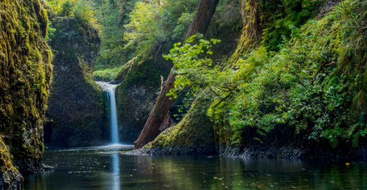
Punch Bowl Falls — Columbia River Gorge, Oregon

The name says it all: Punch Bowl Falls pours into a perfectly rounded bowl-shaped pool of striking turquoise water, creating one of the most visually satisfying waterfall scenes in the entire Columbia River Gorge. The pool looks almost artificially perfect, like someone carved it specifically for maximum photographic impact.
Spoiler: nature just showed off here.
Reaching the base of Punch Bowl Falls requires hiking the Eagle Creek Trail, one of the most beloved trails in the Gorge. The main viewpoint is about 2 miles from the trailhead, but continuing to the base of the falls adds another mile and involves some scrambling over rocks.
The extra effort is absolutely worth it for the up-close view of the turquoise pool.
Eagle Creek Trail was partially closed for years following the catastrophic 2017 Eagle Creek Fire, which burned through much of this section of the Gorge. Sections have since reopened and the forest is actively recovering, with young trees and wildflowers reclaiming the hillsides in a remarkable display of natural resilience.
Always check current trail conditions before heading out, as closures can still occur after storms or during fire danger periods. This trail rewards patient and prepared hikers generously.
Latourell Falls — Columbia River Gorge, Oregon

Latourell Falls makes a statement the second it comes into view. A single, uninterrupted 249-foot plunge alongside towering basalt columns covered in brilliant yellow lichen creates one of the most dramatic waterfall compositions in Oregon.
The color contrast between the dark rock, golden lichen, and white cascade is genuinely stunning in any season.
Unlike many Gorge waterfalls that require a long hike, Latourell delivers maximum impact with minimal effort. The main viewpoint is just a few steps from the parking area, making it one of the most accessible big waterfalls in the state.
A short loop trail of about 2.4 miles climbs above the falls for an aerial perspective that offers a completely different and equally impressive view.
Latourell Falls sits along the Historic Columbia River Highway, just west of Crown Point, making it a natural first or last stop on a Gorge waterfall road trip. The falls are named after Joseph Latourell, an early settler who operated a ferry nearby in the 1870s.
The surrounding Guy W. Talbot State Park provides picnic areas and well-maintained trails.
Winter visits are particularly dramatic, when ice formations sometimes cling to the basalt walls and frost dusts the surrounding forest in a quiet, otherworldly scene.


