There is a stretch of southern Indiana where the Ohio River bends, the trees grow thick, and an old amusement park quietly waits beneath the forest floor. Most people drive right past it on IN-62 without ever knowing what lies at the bottom of that steep, paved hill.
Rose Island Resort was once a buzzing summer destination that drew thousands of guests from across the region, but a catastrophic flood in 1937 changed everything. What remains today is a layered, outdoor history walk tucked inside Charlestown State Park, where trail markers, stone ruins, and flood level signs tell the story better than any museum could.
This is not a manicured tourist attraction with gift shops and crowds. It is quiet, a little wild, and genuinely worth every step of that uphill return trip.
A Resort That Time and Water Erased

Before the trees reclaimed it, Rose Island was a full-blown resort and amusement park that operated from the early 1900s until the great Ohio River flood of January 1937 swept most of it away in a matter of days.
At its peak, the resort featured a hotel, a dance hall, a swimming pool, a Ferris wheel, a roller coaster, and a carousel, drawing crowds from Louisville, Kentucky and towns across southern Indiana every summer weekend.
The 1937 flood was one of the worst in Ohio River history, and Rose Island sat directly in its path. The water rose so high that nearly every structure on the property was either destroyed or rendered unusable.
Rather than rebuild, the owners eventually walked away, and the land was later absorbed into what became Charlestown State Park. That history is what makes the hike feel like more than just a walk through the woods.
The Trail Down Is Deceptively Easy

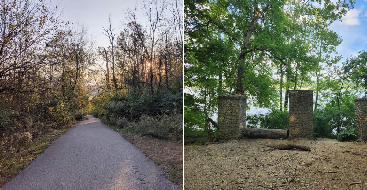
The main route to Rose Island follows a wide, paved path that descends steeply for roughly half a mile from the parking area down to the old resort grounds near the river.
Going down feels manageable, even pleasant, with tree cover keeping the trail shaded on warm days. The pavement is in good condition, and the grade is consistent enough that most people make it to the bottom without much trouble.
What catches people off guard is the return trip. That same half mile becomes a real cardiovascular workout on the way back up, and the incline is steep enough that rest stops are genuinely necessary for many hikers.
The trail includes a few benches along the paved section, and stopping to catch a breath is completely normal. Comfortable walking shoes with good grip are a smart choice, and bringing enough water for the full round trip is something worth planning ahead.
What Is Actually Left to See

Honest expectations make all the difference here. The physical remains of Rose Island are sparse, and anyone hoping to find a dramatic abandoned amusement park with standing structures will likely feel surprised by what greets them at the bottom of the hill.
What does exist is genuinely interesting. Informational signs are posted throughout the grounds, marking where specific attractions once stood and explaining their history in clear, readable language.
Stone foundations, partial walls, and flood level markers give a sense of scale for what the 1937 event actually looked like.
A wooden bridge crosses over to the island portion of the site, and that crossing alone offers a solid view of the surrounding river landscape. There is also what many believe to be an original picnic table still sitting on the grounds, which has become something of an unofficial landmark among regular visitors.
The site rewards curiosity more than it rewards passive observation, so reading every sign along the way adds real depth to the experience.
The Guided Tour Changes Everything

For anyone who wants more than a self-guided walk through weathered signs, the guided tour offered at Charlestown State Park is the version of Rose Island that sticks with people long after they leave.
Tours have been led by a knowledgeable park guide whose storytelling approach goes well beyond reciting dates and facts. The narrative covers the resort’s rise, its regular guests, its entertainment lineup, and the dramatic end brought by the 1937 flood, all delivered in a way that makes the timeline feel vivid and connected.
Tour groups travel to the site by van rather than on foot, which makes this option accessible for older adults, young children, and anyone who would find the steep trail physically difficult. Dogs are welcome on the walking trail but not on the van tour.
Tour availability has historically been offered on Fridays and Saturdays, though schedules can shift by season, so checking with the park directly before visiting is the best approach.
Trail 3 and the Alternate Route Back

There is an alternate return route from Rose Island that gets mentioned often as an easier option than climbing back up the main paved hill. Trail 3 is longer by about a quarter mile and runs through the woods rather than up the open asphalt path.
The entrance to Trail 3 is found to the right after crossing the bridge on the way back toward the parking lot. It is not always clearly marked, but most hikers who have been looking for it manage to find the opening without too much difficulty.
Here is the honest reality: Trail 3 is not easier in the way that most people interpret that word. The path is narrower, runs through a dry creek bed in places, and involves tree roots, rocks, mud after rain, and some steep sections that require careful footing.
For a group that is comfortable with uneven terrain and wants a more natural hiking experience, it works well. For anyone expecting a gentle stroll, the main paved hill is the safer and more predictable choice.
Photography Along the Grounds

Rose Island has built a quiet reputation among outdoor photographers, and it is easy to understand why once you are standing among the ruins with the river visible through the tree line.
The combination of old stonework, overgrown vegetation, weathered signage, and the natural river landscape creates a range of subjects that work well across seasons. Spring brings green growth pushing through the foundations.
Late summer keeps the canopy full and the light filtered. Fall turns the surrounding hillside into a patchwork of color that frames the ruins in a completely different way.
The bridge crossing to the island itself is one of the more popular spots for photos, offering a clear line of sight toward the water and the old resort grounds beyond. Flood level markers along the path also make for striking images that put the scale of the 1937 event into visual context.
No special equipment is needed, and the natural light along the shaded trail tends to be forgiving throughout most of the day.
What to Pack Before You Head Down

A little preparation goes a long way at Rose Island, and the most common piece of feedback from people who have made the trip is that they wished they had brought more water.
The round trip hike, including time spent walking the grounds, typically runs between one and two hours depending on pace and how long visitors spend reading the informational signs. That is enough time to work up a real thirst, especially on warm summer days when the humidity in southern Indiana is at its peak.
Good walking shoes with solid grip are strongly recommended. The paved hill is manageable in most footwear, but the alternate Trail 3 route involves mud, rocks, and roots that require more ankle support and traction.
Restrooms are available at the park office and gift shop area near the entrance, but there are no facilities near the Rose Island site itself, so planning accordingly before heading down the hill is a practical step that saves a lot of inconvenience later.
The Flood Markers Tell the Real Story

Among the details scattered across the Rose Island grounds, the flood level markers are the ones that tend to stop people mid-step and make the history feel genuinely real rather than abstract.
The 1937 Ohio River flood is recorded as one of the most destructive in the river’s history, and the markers placed along the trail show exactly how high the water reached during that event. Standing next to one of those markers and looking at the height indicator puts the destruction of the resort into an entirely new perspective.
The Ohio River runs along the southern edge of the property, and its presence is a constant backdrop to the entire site. Understanding that this same river rose high enough to erase a fully operational resort makes the quiet, overgrown landscape feel much more layered than it might appear on the surface.
These markers are one of the strongest arguments for reading every sign on the trail rather than walking through quickly and heading back to the parking lot.
The Broader Charlestown State Park Experience

Rose Island is the most historically distinctive feature of Charlestown State Park, but the park itself offers considerably more than one trail and one destination.
The park covers over 2,000 acres and includes multiple trail systems that range from relatively flat woodland paths to more demanding ridge routes with elevated views of the surrounding landscape. Hikers who arrive specifically for Rose Island often end up spending a full day in the park after discovering how much additional trail mileage is available.
The park sits in a part of Indiana where the terrain is noticeably more rugged than the flat agricultural land that defines much of the state. The combination of river access, forested ridges, and historic significance makes Charlestown State Park a destination that holds up across multiple visits rather than feeling exhausted after one.
Seasonal changes shift the character of the trails considerably, and the park draws a steady mix of local regulars and out-of-state visitors who make the drive specifically for the Rose Island history component.
Planning Your Visit the Right Way

Getting the most out of a trip to Rose Island comes down to a few practical decisions made before arriving at the park gate on IN-62.
Weekday visits tend to be quieter than weekend trips, which is worth considering for anyone who prefers a more solitary experience on the trail. The park is open daily from 7 AM to 11 PM, so early morning arrivals have the advantage of cooler temperatures and fewer other hikers on the path down to the resort grounds.
Checking the Indiana DNR website at in.gov/dnr before the visit is genuinely useful. Tour schedules, trail condition updates, and any seasonal programming information are posted there regularly and can shape how the day is organized.
State park entrance fees apply, so having payment ready at the gate keeps things moving. For first-time visitors who want the full historical context without doing independent research on the trail, booking a guided tour in advance is the single most effective way to make the experience count.
Where Exactly is It

The full address for this historic site is 12500 IN-62, Charlestown, IN 47111, and it sits within the boundaries of Charlestown State Park in Clark County, southern Indiana, right along the Ohio River.
The park itself is open daily from 7 AM to 11 PM, giving hikers and history enthusiasts a generous window to explore without feeling rushed.
Rose Island is not a standalone facility with its own entrance. It is accessed through the state park, which means visitors should plan to enter through the main park gate and follow the trail system down toward the river bottom where the old resort grounds are located.
The Indiana Department of Natural Resources manages the entire area, and their website at in.gov/dnr is the best place to check for updated trail conditions, guided tour schedules, and any seasonal closures before making the trip down.


